 Shown within Sudan | |
| Location | Northern, Sudan |
|---|---|
| Region | Old Kingdom |
| Coordinates | 22°05′N31°40′E / 22.083°N 31.667°E |
Debeira is an archaeological site in Sudan situated on the eastern bank of the Nile some 20 kilometres north of Wadi Halfa.
| Shown within Sudan | |
| Location | Northern, Sudan |
|---|---|
| Region | Old Kingdom |
| Coordinates | 22°05′N31°40′E / 22.083°N 31.667°E |
Debeira is an archaeological site in Sudan situated on the eastern bank of the Nile some 20 kilometres north of Wadi Halfa.
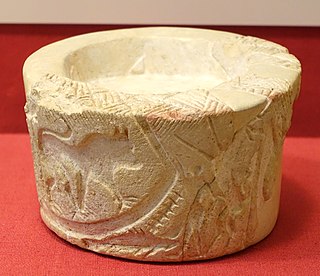
Excavations brought to light a necropolis of the C-Group culture. [1] The necropolis site dates to ca. 2400–1550 BCE.
At Debeira-East a wall-painted funerary chapel of the Nubian prince (chief of Teh-khet) Djehutyhotep from the time of Hatshepsut and Thutmosis III was found. [2] Other finds include a painted sarcophagus with iconography of the Twentieth Dynasty of Egypt. [1] The sarcophagus and the painted scenes of the burial chamber were taken to the Sudan National Museum in Khartoum prior to the flooding of Debeira by Lake Nasser.
The site was occupied by a small town or large village in the middle ages. Excavations between 1961 and 1964 by the University of Ghana showed the existence of a town with churches, a cemetery, and several large buildings. The site was inhabited between the 7th and 9th century, and abandoned after a decline that continued into the tenth century. The site was later redeveloped in the 11th century. The community consisted of several hundred people during this period. [3]

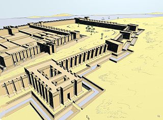
Memphis or Men-nefer was the ancient capital of Inebu-hedj, the first nome of Lower Egypt that was known as mḥw ("north"). Its ruins are located in the vicinity of the present-day village of Mit Rahina, in markaz (county) Badrashin, Giza, Egypt. This modern name is probably derived from the late Ancient Egyptian name for Memphis mjt-rhnt meaning "Road of the Ram-Headed Sphinxes".
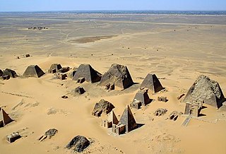
Meroë was an ancient city on the east bank of the Nile about 6 km north-east of the Kabushiya station near Shendi, Sudan, approximately 200 km north-east of Khartoum. Near the site is a group of villages called Bagrawiyah. This city was the capital of the Kingdom of Kush for several centuries from around 590 BC, until its collapse in the 4th century AD. The Kushitic Kingdom of Meroë gave its name to the "Island of Meroë", which was the modern region of Butana, a region bounded by the Nile, the Atbarah and the Blue Nile.
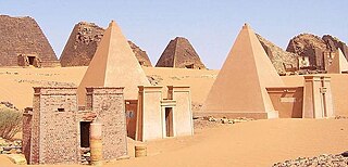
The Nubian pyramids were built by the rulers of the ancient Kushite kingdoms. The area of the Nile valley known as Nubia, which lies in northern present-day Sudan, was the site of three Kushite kingdoms during antiquity. The capital of the first was at Kerma. The second was centered on Napata. The third kingdom was centered on Meroë. The pyramids are built of granite and sandstone.
Makuria was a medieval Nubian kingdom in what is today northern Sudan and southern Egypt. Its capital was Dongola in the fertile Dongola Reach, and the kingdom is sometimes known by the name of its capital.

Kerma was the capital city of the Kerma culture, which was located in present-day Sudan at least 5,500 years ago. Kerma is one of the largest archaeological sites in ancient Nubia. It has produced decades of extensive excavations and research, including thousands of graves and tombs and the residential quarters of the main city surrounding the Western/Lower Deffufa.

Alodia, also known as Alwa, was a medieval kingdom in what is now central and southern Sudan. Its capital was the city of Soba, located near modern-day Khartoum at the confluence of the Blue and White Nile rivers.
Old Dongola is a deserted town in what is now Northern State, Sudan, located on the east bank of the Nile opposite the Wadi Howar. An important city in medieval Nubia, and the departure point for caravans west to Darfur and Kordofan, from the fourth to the fourteenth century Old Dongola was the capital of the Makurian state. A Polish archaeological team has been excavating the town since 1964.
The Kerma culture or Kerma kingdom was an early civilization centered in Kerma, Sudan. It flourished from around 2500 BC to 1500 BC in ancient Nubia. The Kerma culture was based in the southern part of Nubia, or "Upper Nubia", and later extended its reach northward into Lower Nubia and the border of Egypt. The polity seems to have been one of a number of Nile Valley states during the Middle Kingdom of Egypt. In the Kingdom of Kerma's latest phase, lasting from about 1700 to 1500 BC, it absorbed the Sudanese kingdom of Sai and became a sizable, populous empire rivaling Egypt. Around 1500 BC, it was absorbed into the New Kingdom of Egypt, but rebellions continued for centuries. By the eleventh century BC, the more-Egyptianized Kingdom of Kush emerged, possibly from Kerma, and regained the region's independence from Egypt.

Tomb WV23, also known as KV23, is located in the Western Valley of the Kings near modern-day Luxor, and was the final resting place of Pharaoh Ay of the Eighteenth Dynasty. The tomb was discovered by Giovanni Battista Belzoni in the winter of 1816. Its structure is similar to that of the tomb of Akhenaten, with a straight descending corridor, leading to a "well chamber" that has no shaft. This leads to the burial chamber, which now contains the reconstructed sarcophagus, which had been smashed in antiquity. The tomb had also been anciently desecrated, with many instances of Ay's image or name erased from the wall paintings. Its decoration is similar in content and colour to that of Tutankhamun (KV62), with a few differences. On the eastern wall there is a depiction of a fishing and fowling scene, which is not shown elsewhere in other royal tombs, normally appearing in burials of nobility.
Buhen was an ancient Egyptian settlement situated on the West bank of the Nile below the Second Cataract in what is now Northern State, Sudan. Buhen, as a settlement was established during the Old Kingdom, but the fortress which Buhen is famous for was not established until the Middle Kingdom. During the Old Kingdom, Buhen was primarily used to smelt copper, until the Middle Kingdom, when the site was used by Egyptians to maintain the new southern border of Egypt.

The Istanbul Archaeology Museums are a group of three archaeological museums located in the Eminönü quarter of Istanbul, Turkey, near Gülhane Park and Topkapı Palace.

The region of Semna is 15 miles south of Wadi Halfa and is situated where rocks cross the Nile narrowing its flow—the Semna Cataract.

Nubia is a region along the Nile river encompassing the area between the first cataract of the Nile and the confluence of the Blue and White Niles, or more strictly, Al Dabbah. It was the seat of one of the earliest civilizations of ancient Africa, the Kerma culture, which lasted from around 2500 BC until its conquest by the New Kingdom of Egypt under Pharaoh Thutmose I around 1500 BC, whose heirs ruled most of Nubia for the next 400 years. Nubia was home to several empires, most prominently the Kingdom of Kush, which conquered Egypt in the eighth century BC during the reign of Piye and ruled the country as its 25th Dynasty.

Siaspiqa was a ruler of the Kushite kingdom of Meroë reigning for close to twenty years in the first half of the 5th century BC. Very little is known of Siaspiqa's activities beyond the construction of his pyramid at Nuri, now known as Nuri 4. The pyramid and its chapel have yielded several inscribed stelas bearing his name as well as numerous artefacts suggesting a once rich burial. Nothing is known for certain on the relations between Siaspiqa and his predecessor Amaniastabarqa and successor Nasakhma. Equally uncertain is the identity of his consort, with queen Pi'ankhqewqa buried in the nearby Nuri 29 conjectured for that role.
Qustul is an archaeological cemetery located on the eastern bank of the Nile in Lower Nubia, just opposite of Ballana near the Sudan frontier. The site has archaeological records from the A-Group culture, the New Kingdom of Egypt and the X-Group culture.

Amenemhat was a Nubian official under Hatshepsut and Thutmosis III. He was chief of Teh-khet and was therefore a governor ruling a region in Lower Nubia for the Egyptian state. In the New Kingdom, Egyptian kings had conquered Lower Nubia. To secure control over the new region they appointed people of the local elite as governors. Teh-khet was a Nubian region that covered the area about Debeira and Serra. The local governors here formed a family, while the governor proper held the title chief of Teh-khet.
Djehutyhotep, also called Paitsy, was a Nubian official under Hatshepsut and Thutmosis III. He was chief of Teh-khet and was therefore a governor ruling a region in Lower Nubia of the Egyptian state. In the New Kingdom, Egyptian kings had conquered Lower Nubia. To secure control over the new region they appointed people of the local elite as governors. Teh-khet was a Nubian region that covered the area about Debeira and Serra. The local governors here formed a family, while the governor proper held the title chief of Teh-khet. Djehutyhotep's father Ruiu was also chief of Teh-khet. His mother was called Runia. His wife was called Tenetnub. His brother Amenemhat was also chief of Teh-khet and followed Djehutyhotep in office.
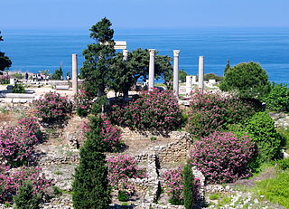
The royal necropolis of Byblos is a group of nine Bronze Age underground shaft and chamber tombs housing the sarcophagi of several kings of the city. Byblos is a coastal city in Lebanon, and one of the oldest continuously populated cities in the world. The city established major trade links with Egypt during the Bronze Age, resulting in a heavy Egyptian influence on local culture and funerary practices. The location of ancient Byblos was lost to history, but was rediscovered in the late 19th century by the French biblical scholar and Orientalist Ernest Renan. The remains of the ancient city sat on top of a hill in the immediate vicinity of the modern city of Jbeil. Exploratory trenches and minor digs were undertaken by the French mandate authorities, during which reliefs inscribed with Egyptian hieroglyphs were excavated. The discovery stirred the interest of western scholars, leading to systematic surveys of the site.

The International Campaign to Save the Monuments of Nubia was the relocation of 22 monuments in Lower Nubia, in Southern Egypt and northern Sudan, between 1960 and 1980. The success of the project, in particular the creation of a coalition of 50 countries behind the project, led to the creation of the World Heritage Convention in 1972, and thus to the modern system of World Heritage Sites.

Gebel Adda was a mountain and archaeological site on the right bank of the Nubian Nile in what is now southern Egypt. The settlement on its crest was continuously inhabited from the late Meroitic period to the Ottoman period, when it was abandoned by the late 18th century. It reached its greatest prominence in the 14th and 15th centuries, when it seemed to have been the capital of late kingdom of Makuria. The site was superficially excavated by the American Research Center in Egypt just before being flooded by Lake Nasser in the 1960s, with much of the remaining excavated material, now stored in the Royal Ontario Museum in Canada, remaining unpublished. Unearthed were Meroitic inscriptions, Old Nubian documents, a large amount of leatherwork, two palatial structures and several churches, some of them with their paintings still intact. The nearby ancient Egyptian rock temple of Horemheb, also known as temple of Abu Oda, was rescued and relocated.