Debsa Pass

Last updated

Debsa Pass
Map of Himachal Pradesh.png
Red pog.svg
Location India
Coordinates 31°54′15″N77°48′07″E / 31.90417°N 77.80194°E / 31.90417; 77.80194 Coordinates: 31°54′15″N77°48′07″E / 31.90417°N 77.80194°E / 31.90417; 77.80194

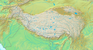
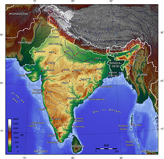
Debsa Pass is a 5,360-metre-high (17,590 ft) mountain pass in the Himalaya mountains between the Kullu and Spiti Districts of Himachal Pradesh, India.

Mountain pass Route through a mountain range or over a ridge

A mountain pass is a navigable route through a mountain range or over a ridge. Since many of the world's mountain ranges have presented formidable barriers to travel, passes have played a key role in trade, war, and both human and animal migration throughout Earth's history. At lower elevations it may be called a hill pass. The highest vehicle-accessible pass in the world appears to be Mana Pass, located in the Himalayas on the border between India and Tibet, China.

Kullu or Kulu is the capital town of the Kullu district in the Indian state of Himachal Pradesh. It is located on the banks of the Beas River in the Kullu Valley about 10 kilometres (6.2 mi) north of the airport at Bhuntar.

Himachal Pradesh State in Northern India

Himachal Pradesh is a state in the northern part of India. Situated in the Western Himalayas, it is bordered by states of Jammu and Kashmir on the north, Punjab on the west, Haryana on the southwest, Uttarakhand on the southeast, and Tibet on the east. At its southernmost point, it also touches the state of Uttar Pradesh. The state's name was coined by acharya Diwakar Datt Sharma, one of the state's eminent Sanskrit scholars.

Joydeep Sircar led the teams that explored the watershed ridge and discovered the pass after approaching through the Parbati River valley in Kullu. After an abortive attempt on an impassable col further north in 1992, the pass was located and reached in 1993, but the team refrained from crossing it into Spiti under the mistaken impression that they could be arrested because they did not have Inner Line Permits required for Spiti. Two years later, the 1995 team planned to approach from the Spiti side, which involves much less height gain, but tremendous autumn floods in the upper valley of the Beas River and other areas of Himachal which wrecked roads forced them to take the Parbati approach again. This time they crossed the pass on 21 September and completed the route from Manikaran to Kaja.

Joydeep Sircar is a mountaineer and mountain historian. In 1979, he published his Himalayan Handbook, an index of all the-then named peaks of 6096 meters (20000 feet) and above in Afghanistan and the Indian subcontinent, giving chronological entries of expeditions up to 1975 to each peak with a brief summary of results and references to expedition reports, after a decade of solitary research. He was inspired in this formidable undertaking by the pronouncement of the late Soli S. Mehta, Hony. Local Secretary of The Himalayan Club, that the task had never been attempted before and was well-nigh impossible. This book, introduced by the famous British mountaineer-explorer J. O. M. Roberts, one of Sircar's idols, was the first one of its kind. Printed in 500 copies only, it received excellent international notices and became a basic reference resource.

Beas River River in north India

The Beas River is a river in north India. The river rises in the Himalayas in central Himachal Pradesh, India, and flows for some 470 kilometres (290 mi) to the Sutlej River in the Indian state of Punjab. Its total length is 470 kilometres (290 mi) and its drainage basin is 20,303 square kilometres (7,839 sq mi) large.

Leomann's 1:200,000 map of Himachal Pradesh (Third Edition, 2005) shows a dotted track beginning at a point between the Kach (should read Kachh) and Bara Dwari Thach campsites, and crossing the Kullu-Spiti watershed divide into the West Debsa Glacier to follow the West Debsa and Debsa streams to Thidim (should be Thango) in the Parahio Valley. This is a fairly accurate representation of the 1995 route, though the pass is unmarked.

Related Research Articles

Rohtang Pass mountain pass

Rohtang Pass, is a high mountain pass on the eastern Pir Panjal Range of the Himalayas around 51 km (32 mi) from Manali. It connects the Kullu Valley with the Lahaul and Spiti Valleys of Himachal Pradesh, India.

Manali, Himachal Pradesh Town in Himachal Pradesh, India

Manali is a resort town nestled in the mountains of the Indian state of Himachal Pradesh near the northern end of the Kullu Valley in the Beas River Valley. It is located in the Kullu district, about 270 km (168 mi) north of the state capital, Shimla, 309 km north east of Chandigarh and 544 km northeast of Delhi, the federal capital. The small town, with a population of 8,096, is the beginning of an ancient trade route to Ladakh and from there over the Karakoram Pass on to Yarkand and Khotan in the Tarim Basin. It is a popular tourist destination and serves as the gateway to Lahaul and Spiti district as well as Leh.

Parvati Valley is situated in the northern Indian state of Himachal Pradesh. From the confluence of the Parvati River with the River Beas, the Parvati Valley runs eastwards, through a steep-sided valley from the town of Bhuntar, in the Kullu district of Himachal Pradesh in Northern India.

Parvati River (Himachal Pradesh) river in Asia

Parvati River is a river in the Parvati Valley in Himachal Pradesh, northern India that flows into the Beas River at Bhuntar, some 10 km south of Kullu. It rises from the Man Talai Glacier below the Pin Parbati pass and flows in a gradual curve from north-northwest to west-southwest past the important temple town of Manikaran.

Pir Panjal Range mountains in India

The Pir Panjal Range is a group of mountains in the Inner Himalayan region, running from east-southeast (ESE) to west-northwest (WNW) across the Indian states of Himachal Pradesh and Jammu and Kashmir where the average elevation varies from 1,400 m (4,600 ft) to 4,100 m (13,500 ft). The Himalayas show a gradual elevation towards the Dhauldhar and Pir Panjal ranges. Pir Panjal is the largest range of the lower Himalayas. Near the bank of the Sutlej river, it dissociates itself from the Himalayas and forms a divide between the rivers Beas and Ravi on one side and the Chenab on the other. The renowned Galyat mountains are also located in this range.

Great Himalayan National Park national park

The Great Himalayan National Park (GHNP), is one of India's national parks, is located in Kullu region in the state of Himachal Pradesh. The park was established in 1984 and is spread over an area of 1,171 km2 at an altitude of between 1500 and 6000 m. The Great Himalayan National Park is a habitat to numerous flora and more than 375 fauna species, including approximately 31 mammals, 181 birds, 3 reptiles, 9 amphibians, 11 annelids, 17 mollusks and 127 insects. They are protected under the strict guidelines of the Wildlife Protection Act of 1972; hence any sort of hunting is not permitted.

Spiti Valley

Spiti Valley is a cold desert mountain valley located high in the Himalayas in the north-eastern part of the northern Indian state of Himachal Pradesh. The name "Spiti" means "The Middle Land", i.e. the land between Tibet and India.

The Pin Parbati Pass is a mountain pass in Himachal Pradesh, India, at 5,319 meters. It was first crossed in August 1884 by Sir Louis Dane in search of an alternate route to the Spiti valley. This pass connects the fertile and lush Parbati valley on the Kullu side with the Pin valley on the Spiti side.

Manirang

Manirang is one of the highest mountains in the Indian state Himachal Pradesh. It lies on the border between Kinnaur district and Lahaul and Spiti district. Close to the peak is the high Manirang pass, which was one of the early trade routes between Spiti and Kinnaur, before the motorable road was built.

Ramabang is a 6,135-metre (20,128 ft) mountain in the Himalayas, in the Lahaul and Spiti district of Himachal Pradesh, India.

Indian Himalayan Region region in northern India

The Indian Himalayan Region (IHR) is the section of the Himalayas within India, spanning 6 Indian states namely, Jammu & Kashmir, Himachal Pradesh, Uttarakhand, Sikkim, Arunachal Pradesh and West Bengal of Indian Republic. The region is responsible for providing water to a large part of the Indian subcontinent and contains various flora and fauna.

Kunzum Pass

Kunzum Pass (Tibetan: Kunzum La,, is a high mountain pass on the eastern Kunzum Range of the Himalayas some 122 km from Manali. It connects the Kullu Valley and Lahaul Valley with the Spiti Valley of Himachal Pradesh, India. It is on the route to Kaza the subdivisional headquarters of Spiti. There is also a 15 km trek to the Moon Lake of the Chandratal from the Kunzum Pass. It consists of fifteen sharp hairpin turns, testing driving skills of even experienced drivers. The drivers, travelers and passerby seeks blessings of Kunzum mata before undertaking the dangerous journey.

Kaza, Himachal Pradesh town in Himachal Pradesh, India

The town of Kaza or Kaze is the subdivisional headquarters of the remote Spiti Valley in the western Himalayas in the Lahaul and Spiti district of the northern Indian state of Himachal Pradesh. Spiti is a high altitude or cold desert having close similarities to the neighbouring Tibet and Ladakh regions in terms of terrain, climate and the Buddhist culture. Kaza, situated along the Spiti River at an elevation of 3,650 metres (11,980 ft) above mean sea level, is the largest township and commercial center of the Spiti valley.

National Highway 3 (India) national highway in India

National Highway 3, or NH 3, is a national highway in India. It starts from Atari adjacent to India-Pakistan border and near Amritsar and terminates at Leh in Jammu and Kashmir, via Manali in Himachal Pradesh.

Shilla Col is a col in the remote Trans-Himalayan region of Spiti, Himachal Pradesh, India. It connects Shilla Nullah to Upper Lingti Valley. Coordinates are: 32°25'38"N 78°12'16"E

Reo Purgyil

Reo Purgyil, sometimes known as Leo Pargial and Leo Pargil, is a mountain peak at the southern end of the Zanskar Range in the Western Himalaya area of the Himalayas. It is located on the Himachal Pradesh/Tibetan border in the Kinnaur district of Himachal Pradesh, India.

Chau Chau Kang Nilda Mountain in Himachal Pradesh

Chau Chau Kang Nilda also known as 'Guan Nelda' or 'blue moon in the sky' is a mountain in the western Himalayas. It lies in the northern Indian state of Himachal Pradesh.

References

Royal Geographical Society British learned society

The Royal Geographical Society is the UK's learned society and professional body for geography, founded in 1830 for the advancement of geographical sciences. Today, it is the leading centre for geographers and geographical learning. The Society has over 16,500 members and its work reaches millions of people each year through publications, research groups and lectures.

London Capital of the United Kingdom

London is the capital and largest city of both England and the United Kingdom. Standing on the River Thames in the south-east of England, at the head of its 50-mile (80 km) estuary leading to the North Sea, London has been a major settlement for two millennia. Londinium was founded by the Romans. The City of London, London's ancient core − an area of just 1.12 square miles (2.9 km2) and colloquially known as the Square Mile − retains boundaries that follow closely its medieval limits. The City of Westminster is also an Inner London borough holding city status. Greater London is governed by the Mayor of London and the London Assembly.

Indian Mountaineering Foundation organization

Indian Mountaineering Foundation is an apex national body which organize and support, mountaineering and rock climbing expeditions at high altitudes in the Himalayas. The organization also promote and encourage schemes for related adventure activities and environmental protection work in the Indian Himalayas. IMF has organized many expeditions to the high peaks in the Himalayas including Mt.Everest.