
Kodagu district is an administrative district in the Karnataka state of India. Before 1956, it was an administratively separate Coorg State, at which point it was merged into an enlarged Mysore State.

Dakshina Kannada district is located in the state of Karnataka in India, with its headquarters in the coastal city of Mangalore. It is part of the larger Tulu Nadu region. The district covers an area nestled in between the Western Ghats to its east and the Arabian Sea to its west. Dakshina Kannada receives abundant rainfall during the Indian monsoon. It is bordered by Udupi district to the north, Chikmagalur district to the northeast, Hassan district to the east, Kodagu to the southeast and Kasaragod district of Kerala to the south. According to the 2011 census of India, Dakshina Kannada district had a population of 2,083,625. It is the only district in Karnataka state to have all modes of transport like road, rail, water and air due to the presence of a major hub, Mangalore. This financial district is also known as the Cradle of Indian banking.
The Biligirirangana Hills or Biligirirangan Hills is a hill range situated in south-western Karnataka, at its border with Tamil Nadu in South India. The area is called Biligiri Ranganatha Swamy Temple Wildlife Sanctuary or simply BRT Wildlife Sanctuary. It is a protected reserve under the Wildlife Protection Act of 1972. Being close to the Eastern Ghats as well as the Western Ghats, the sanctuary has floral and faunal associations with both regions. The site was declared a tiger reserve in January 2011 by the Government of Karnataka, a few months after approval from India's National Tiger Conservation Authority.

Hassan is one of the 31 districts of Karnataka, India. The district headquarter is Hassan. It was carved out from Mysore district in the year 1866, during the Commissioner's Rule of Mysore (1831-81).

Somwarpet is a panchayat town in Kodagu district in the Indian state of Karnataka. It is the main town of the Somwarpet taluk, in the north-east of the district. 2nd highest Administrative town in Karnataka in terms of elevation. The main crops grown in the area are coffee and spice crops such as cardamom, peppers, oranges, ginger and vegetables.

Sakleshpur, Sakleshpura or Sakleshapura is a hill station town and headquarters of Sakleshpur taluk in Hassan district in the Indian state of Karnataka.

Kukke Subramanya is a Hindu temple located in the village Subramanya, of Kadaba taluk in Dakshina Kannada district, Karnataka, India. In this temple Kartikeya is worshipped as Subramanya, lord of all serpents. The epics relate that the divine serpent Vasuki and other serpents found refuge under Subramanya when threatened by the Garuda. The priests in the temple are Madhva Brahmins. The poojas and other daily rituals in the temple are performed as per Madhvacharya's Tantra Sara Sangraha.
Subramanya is a village located in Kadaba Taluk in Dakshina Kannada, India. The Kukke Subrahmanya Temple is located here. It is about 105 kilometres (65 mi) from Mangalore, connected by train and road. It was originally named "Kukke Pattana".
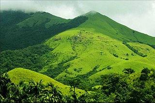
Pushpagiri, at 5,626 feet (1,715 m) ft, is the highest peak in Pushpagiri Wildlife Sanctuary, located along the Western Ghats of Karnataka. It is located in Somwarpete taluk, 20 kilometres (12 mi) from Somwarpet in the northern part of Kodagu district on the tri-junction between Dakshina Kannada, Kodagu and Hassan district. It is 4th highest peak of Karnataka.

Pushpagiri Wildlife Sanctuary is one of the 21 Wildlife Sanctuaries in Karnataka, India.

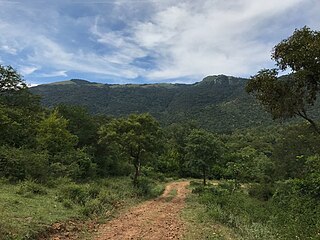
Ghat Roads are access routes into the mountainous Western and Eastern Ghats, mountain ranges of the Indian subcontinent. These roads are remarkable feats of engineering, and most were constructed during the British Raj. Ghat Roads were built to connect to the hill stations established in the mountains for residents to avoid summer heat. They generally served to connect coastal areas with the upper Deccan Plateau.
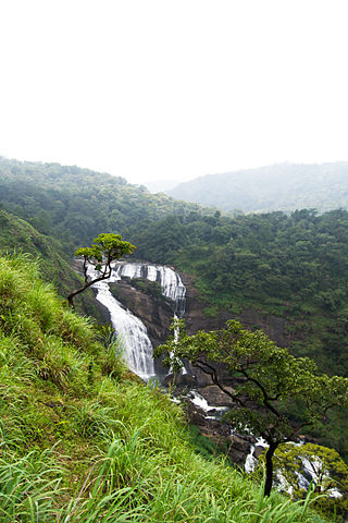
The Kumaradhara River is an Indian river, in the southwestern India state of Karnataka. One of the two major rivers of Sullia, it merges with the Netravati River at Uppinangadi before flowing to the Arabian Sea. The merging of the rivers is a major event for the local villagers, as they crowd the river banks to watch what they call the "Sangama", which is a Sanskrit word for confluence.
Kadaba is a taluk in Dakshina Kannada district of Karnataka, India. It is located 82 km towards East from District headquarters Mangalore, 31 km from Puttur, 38 km from Sullia and 272 km from State capital Bangalore.
Duggaladka is a place in Sullia taluk and village in the Dakshina Kannada district of the state of Karnataka, India. It is a small town, surrounded with evergreen wooded mountains in the Western Ghats range in South India. Duggaladka has plantations of rubber, areca nut, coconut, cashew nut, black pepper and banana. State highway that connects Sullia and Kukke Subramanya runs through Duggaladka. Duggaladka is situated 10 km from Sullia, 30 km from Kukke Subramanya and 90 km from Mangalore.
Cukkemane or Kukkemane or Cuckemane is surname or a family name belonging to members of the Havyaka Brahmin Community. They belong to the Gautama gotra; they originate from and are mainly based in Kodagu (Coorg), Karnataka, a state in South India. They are from Kukke which was part of Amara Sulya district, formerly in the old kingdom of Kodagu.
Gundia River is a second order tributary of the Netravathi river in the state of Karnataka in southern India. A proposal by the Government of Karnataka to build a hydroelectric project across the river and its tributary streams has generated controversy and opposition from environmentalists.
Bisle Reserve Forest is a reserve forest in westernmost Hassan district of Karnataka state, India. It is located in Hassan district's Sakleshpur taluk. Bisle village adjoins the forest to the east. It is contiguous with Kagneri Reserve Forest to the north, Bhagimalai Reserve Forest of Dakshina Kannada district to the west, and Kukke Subramanya forest range to the southwest. To the south it adjoins Pushpagiri Wildlife Sanctuary in Kodagu district. Bisle Reserve forest and the reserve forests extending north along the Bisle Ghat range form a natural corridor linking Pushpagiri Wildlife Sanctuary and Kudremukh National Park.
Somawarpete taluk is one of the five taluks of Kodagu district. Its administrative headquarters is in the town of Somwarpet.
State Highway 85 (SH-85) is a state highway connecting Bengaluru of Bangalore Urban district and Jalsoor village of Dakshina Kannada, in the South Indian state of Karnataka. It has a total length of 346.28 kilometres (215.17 mi).
