
The Western Ghats aka Sahyadri is a mountain range that covers an area of 160,000 km2 (62,000 sq mi) in a stretch of 1,600 km (990 mi) parallel to the western coast of the Indian peninsula, traversing the states of Tamil Nadu, Kerala, Karnataka, Goa, Maharashtra, and Gujarat. It is a UNESCO World Heritage Site and is one of the eight hotspots of biological diversity in the world. It is sometimes called the Great Escarpment of India. It contains a very large proportion of the country's flora and fauna, many of which are only found in India and nowhere else in the world. According to UNESCO, the Western Ghats are older than the Himalayas. They influence Indian monsoon weather patterns by intercepting the rain-laden monsoon winds that sweep in from the south-west during late summer. The range runs north to south along the western edge of the Deccan Plateau, and separates the plateau from a narrow coastal plain, called Konkan, along the Arabian Sea. A total of thirty-nine areas in the Western Ghats, including national parks, wildlife sanctuaries and reserve forests, were designated as world heritage sites in 2012 – twenty in Kerala, ten in Karnataka, six in Tamil Nadu and four in Maharashtra.
Kodagu is an administrative district in the Karnataka state of India. Before 1956, it was an administratively separate Coorg State, at which point it was merged into an enlarged Mysore State. It occupies an area of 4,102 square kilometres (1,584 sq mi) in the Western Ghats of southwestern Karnataka. In 2001 its population was 548,561, 13.74% of which resided in the district's urban centre, making it the least populous of the 30 districts in Karnataka.The nearest railway stations are Mysore Junction, located around 95 km away and Thalassery and Kannur in Kerala, at a distance of 79 km. The nearest airports are Kannur International Airport in Kerala and Mangalore International Airport.

The South Western Ghats montane rain forests are an ecoregion of southern India, covering the southern portion of the Western Ghats range in Karnataka, Kerala and Tamil Nadu, at elevations over 1000 meters. They are cooler and wetter than the lower-elevation South Western Ghats moist deciduous forests, which surround the montane rain forests.

The North Western Ghats montane rain forests is a tropical moist broadleaf forest ecoregion of southwestern India. It covers an area of 30,900 square kilometers (11,900 sq mi), extending down the spine of the Western Ghats range, from southernmost Gujarat through Maharashtra, Goa, and Karnataka. The montane rain forests are found above 1000 meters elevation, and are surrounded at lower elevations by the North Western Ghats moist deciduous forests.
The Biligirirangana Hills or Biligirirangan Hills is a hill range situated in south-western Karnataka, at its border with Tamil Nadu in South India. The area is called Biligiriranganatha Swamy Temple Wildlife Sanctuary or simply BRT Wildlife Sanctuary. It is a protected reserve under the Wildlife Protection Act of 1972. Being close to the Eastern Ghats as well as the Western Ghats, the sanctuary has floral and faunal associations with both regions. The site was declared a tiger reserve in January 2011 by the Karnataka government, a few months after approval from India's National Tiger Conservation Authority.

The Netravati River or Netravathi Nadi has its origins at Bangrabalige valley, Yelaneeru Ghat in Kudremukh in Chikkamagaluru district of Karnataka, India. This river flows through the famous pilgrimage place Dharmasthala and is considered as one of the Holy rivers of India. It merges with the Kumaradhara River at Uppinangadi before flowing to the Arabian Sea, south of Mangalore city. This river is the main source of water to Bantwal and Mangalore. The Netravati railway bridge is one of the known bridges which serve as the gateway to Mangalore.

The Nilgiri Biosphere Reserve is an International Biosphere Reserve in the Western Ghats and Nilgiri Hills ranges of South India. The Nilgiri Sub-Cluster is a part of the Western Ghats, which was declared a World Heritage Site by UNESCO in 2012. It is the largest protected forest area in India, spreading across Tamil Nadu, Karnataka and Kerala. It includes the Aralam, Mudumalai, Mukurthi, Nagarhole, Bandipur and Silent Valley national parks, as well as the Wayanad, Karimpuzha, and Sathyamangalam wildlife sanctuaries.

Kali Tiger Reserve is a protected area and tiger reserve. It is located in Uttara Kannada district, in Karnataka, India. The park is a habitat of Bengal tigers, black panthers and Indian elephants, amongst other distinctive fauna. The Kali River flows through the tiger reserve and is the lifeline of the ecosystem and hence the name. The tiger reserve is spread over an area of 1300 square kilometres.

Nagarhole National Park is a national park located in Kodagu district and Mysore district in Karnataka, India. It is one of India's premier Tiger Reserves along with the adjoining Bandipur Tiger Reserve and Wayanad Wildlife Sanctuary.

Hassan is one of the 31 districts of Karnataka, India. The district headquarter is Hassan.

Sakleshpur, Sakleshpura or Sakleshapura(ಸಕಲೇಶಪುರ) is a hill station town and headquarters of Sakleshpur taluk in Hassan district in the Indian state of Karnataka.
Subramanya is a village located in Sullia Taluk in Dakshina Kannada, India. The Kukke Subrahmanya Temple is located here. It is about 105 kilometres (65 mi) from Mangalore, connected by train and road. It was originally named "Kukke Pattana".
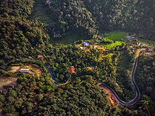
Bisle is a small village in the heart of south-western India's Western Ghats. The village is located in Hassan District's Sakleshpur (Sakaleshpura) Taluk.

Pushpagiri, at 1,712 metres (5,617 ft), is the highest peak in Pushpagiri Wildlife Sanctuary in the Western Ghats of Karnataka. It is located in the Somwarpet Taluk, 20 kilometres (12 mi) from Somwarpet in the northern part of Kodagu district on the border between Dakshina Kannada and Kodagu district and hassan districts. It is 4th highest peak of Karnataka. The Sanskrit name of the mountain is Puṣpagiri while its Prakrit form is Puphagiri, which is mentioned in the Nagarjunakond Second Apsidal Temple inscription, although this may refer to a different mountain to the north of Cuddapah, in Andhra Pradesh.

Pushpagiri Wildlife Sanctuary is one of 21 Wildlife Sanctuaries of India's Karnataka state.
Karnataka, the sixth largest state in India, has been ranked as the third most popular state in the country for tourism in 2014. It is home to 507 of the 3600 centrally protected monuments in India, the largest number after Uttar Pradesh. The State Directorate of Archaeology and Museums protects an additional 752 monuments and another 25,000 monuments are yet to receive protection. Tourism centres on the ancient sculptured temples, modern cities, the hill ranges, forests and beaches. Broadly, tourism in Karnataka can be divided into four geographical regions: North Karnataka, the Hill Stations, Coastal Karnataka and South Karnataka.

Ghat Roads are access routes into the mountainous Western and Eastern Ghats, mountain ranges of the Indian Subcontinent. These roads are remarkable feats of engineering and most were constructed during the British Raj. Ghat roads were built to connect to the famous Hill Stations established in the mountains for residents to avoid summer heat. They generally served to connect coastal areas with the upper region Deccan plateau of the Indian Subcontinent.

The state of Karnataka in South India has a rich diversity of flora and fauna. It has a recorded forest area of 38720 km2 which constitutes 12.3467719% of the total geographical area of the state. These forests support 25% of the elephant population and 20% of the tiger population of India. Many regions of Karnataka are still unexplored and new species of flora and fauna are still found. The Western Ghats mountains in the western region of Karnataka are a biodiversity hotspot. Two sub-clusters of the Western Ghats, Talacauvery and Kudremukh in Karnataka, are in a tentative list of sites that could be designated as World Heritage Sites by UNESCO. The Bandipur and Nagarahole national parks which fall outside these subclusters were included in the Nilgiri biosphere reserve in 1986, a UNESCO designation. Biligiriranga Hills in Karnataka is a place where Eastern Ghats meets Western Ghats. The state bird and state animal of Karnataka are Indian roller and the Indian elephant respectively. The state tree and state flower are sandalwood and lotus respectively. Karnataka is home to 406+ tigers.

The Geography of South India comprises the diverse topological and climatic patterns of South India. South India is a peninsula in the shape of a vast inverted triangle, bounded on the west by the Arabian Sea, on the east by the Bay of Bengal and on the north by the Vindhya and Satpura ranges. Technically all Indian territories below the 20th Parallel.

The Brahmagiri Wildlife Sanctuary is located in Kodagu District, Karnataka State, India, within the Western Ghats and about 250 km from Bangalore. The sanctuary covers an area of about 181 km and derives its name from the highest point of the mountain range, Brahmigiri Peak. It was declared a sanctuary on June 5, 1974.
