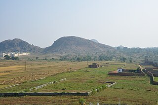
The Chota Nagpur Plateau is a plateau in eastern India, which covers much of Jharkhand state as well as adjacent parts of Chhattisgarh, Odisha, West Bengal and Bihar. The Indo-Gangetic plain lies to the north and east of the plateau, and the basin of the Mahanadi river lies to the south. The total area of the Chota Nagpur Plateau is approximately 65,000 square kilometres (25,000 sq mi).

Dakshina Kannada district is a district of Karnataka state in India, with its headquarters in the coastal city of Mangalore. It is part of the larger Tulu Nadu region. The district covers an area nestled in between the Western Ghats to its east and the Arabian Sea to its west. Dakshina Kannada receives abundant rainfall during the Indian monsoon. It is bordered by Udupi district to the north, Chikmagalur district to the northeast, Hassan district to the east, Kodagu to the southeast and Kasaragod district of Kerala to the south. According to the 2011 census of India, Dakshina Kannada district had a population of 2,083,625. It is the only district in Karnataka state to have all modes of transport like road, rail, water and air due to the presence of a major hub, Mangalore. This financial district is also known as the Cradle of Indian banking.
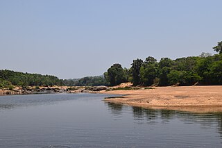
The Tunga River is a river in Karnataka state, southern India. The river is born in the Western Ghats on a hill known as Varaha Parvata at a place called Gangamoola. From here, the river flows through two districts in Karnataka - Chikmagalur District and Shimoga District. It is 147 km long and merges with the Bhadra River at Koodli, a small town near Shimoga City, Karnataka. The river is given the compound name Tungabhadra from this point on. The Tungabhadra flows eastwards and merges with the Krishna River in Andhra Pradesh.
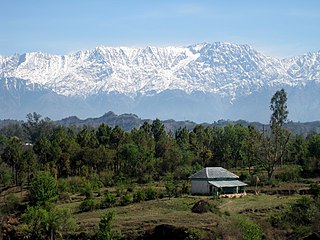
Dhauladhar is a mountain range which is part of a lesser Himalayan chain of mountains. It rises from the Shivalik hills, to the north of Kangra and Mandi. Dharamsala, the headquarters of Kangra district and the winter capital of Himachal Pradesh, lies on its southern spur in the Kangra Valley. Chamba lies to the North of this range.

The Netravati River or Netravathi Nadi has its origins at Bangrabalige valley, Yelaneeru Ghat in Kudremukh in Chikkamagaluru district of Karnataka, India. This river flows through the famous pilgrimage place Dharmasthala and is considered one of the holy rivers of India. It merges with the Kumaradhara River at Uppinangadi before flowing to the Arabian Sea, south of Mangalore city. This river is the main source of water to Bantwal and Mangalore. The Netravati railway bridge is one of the known bridges which serve as the gateway to Mangalore.

Somwarpet is a panchayat town in Coorg district in the Indian state of Karnataka. It is the main town of the Somwarpet taluk, in the north-east of the district. 2nd highest Administrative town in Karnataka in terms of elevation. The main crops grown in the area are coffee and spice crops such as cardamom, peppers, oranges, ginger and vegetables.

The Hemavati is a river in southern India near Karnataka and an important tributary of the Kaveri.

Hornadu, also known as Horanadu, is a Hindu holy locale and also a jain holy centerPanchayat village located in kalasa taluk of Chikkamagaluru district, Karnataka, India. The deity at the Annapoorneshwari Temple at Hornadu is Annapurneshwari. The main deity of the goddess was put in place by Adi Shankaracharya; the new deity of goddess Annapurneshwari was consecrated in the temple in 1973. Horanadu has an elevation of 831 m (2,726 ft)

Sakleshpur, Sakleshpura or Sakleshapura is a hill station town and headquarters of Sakleshpur taluk in Hassan district in the Indian state of Karnataka.
Tarikere is a taluk in the Chikkamagaluru district in the state of Karnataka of India. The headquarters of the taluk is a town of the same name. It is popularly known as gateway of Malnad because the Malnad area starts from here. The town's name is derived from the number of water tanks which surround it.
Varahi River originate and flows through Western Ghats in the Indian state of Karnataka. It is also known as Halady or Haladi river in downstream areas. It joins the Arabian sea after flowing through places like Halady, Basrur, Kundapura and Gangolli. It joins with the Souparnika River, Kedaka River, Chakra River, and Kubja River which are known by Panchagangavalli River and merges into the Arabian Sea. Pancha means five in Kannada and Samskrita and Ganga means river. According to mythology, Varaha is one of the incarnations of Lord Vishnu. Varahi is consort of Varaha.

Kukke Subramanya is a Hindu temple located in the village Subramanya, of Kadaba taluk in Dakshina Kannada district, Karnataka, India. In this temple Kartikeya is worshipped as Subramanya, lord of all serpents. The epics relate that the divine serpent Vasuki and other serpents found refuge under Subramanya when threatened by the Garuda. The priests in the temple are Shivalli Madhva Brahmins. The poojas and other daily rituals in the temple are performed as per Madhvacharya's Tantra Sara Sangraha.
Subramanya is a village located in Kadaba Taluk in Dakshina Kannada, India. The Kukke Subrahmanya Temple is located here. It is about 105 kilometres (65 mi) from Mangalore, connected by train and road. It was originally named "Kukke Pattana".

Pushpagiri, at 5,626 feet (1,715 m) ft, is the highest peak in Pushpagiri Wildlife Sanctuary in the Western Ghats of Karnataka. It is located in the Somwarpet Taluk, 20 kilometres (12 mi) from Somwarpet in the northern part of Kodagu district on the border between Dakshina Kannada and Kodagu district and hassan districts. It is 4th highest peak of Karnataka.
Domah or Doma is a mandal in Vikarabad district of Telangana, India.

Uppinangady or Ubar is a town in the Dakshina Kannada district in the state of Karnataka. It is surrounded by the Kumaradhara River on one side and Nethravathi River on the other. When the town's two surrounding rivers rise during the rainy season and meet, this is called the "Sangam" which is a Sanskrit word for confluence. The Sangam is a major event as people from the surrounding villages crowd the river banks to witness the merge. The population of Uppinangady is 7,172.
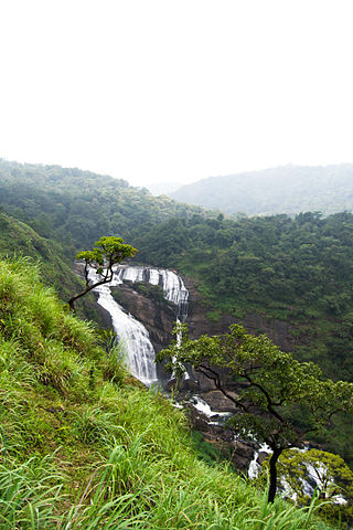
Mallalli Falls is situated in the northern region of Kodagu District, Karnataka. The Kumaradhara River is the main watercourse for this waterfall. The Kumaradhara later flows through Kukke Subrahmanya and merges with the Netravati River at Uppinangadi, which then empties into the Arabian Sea at Mangalore.
Downtown, popularly known as Shahar-e-Khaas, is the largest and the most densely populated area of the city of Srinagar in the union territory of Jammu and Kashmir, India. The area is mostly located on the banks of Jhelum river about five km (3.1 mi) from city center. The area is considered as the core point in the city as the first inhabitants of the Srinagar lived there. In general, the whole area to the north of city centre Lal Chowk is considered a part of downtown although some areas hold high significance. The Jamia Masjid, Srinagar and many other shrines are located here, which makes it the central spiritual, religious, political and moral center of whole Kashmir.
Somawarpete taluk is one of the five taluks of Coorg district. Its administrative headquarters is in the town of Somwarpet.
