Kaveri

Last updated

Kaveri
Cauvery
Kaveri at Shrirangapatnam.JPG
Kaveri River flowing in Srirangapatna
River Cauvery EN.png
Map of the Kaveri River basin
Location
Country India
States Karnataka, Tamil Nadu, Kerala, Puducherry
Region Southern India
Origin Kodagu, Karnataka
Physical characteristics
Source Talakaveri, Kodagu, Western Ghats, Karnataka
  location Karnataka, India
  coordinates 12°23′N75°29′E / 12.383°N 75.483°E / 12.383; 75.483
  elevation1,341 m (4,400 ft)
Mouth Bay of Bengal
  location
Poompuhar, Tamil Nadu, India
  coordinates
11°21′40″N79°49′46″E / 11.36111°N 79.82944°E / 11.36111; 79.82944
  elevation
0 m (0 ft)
Length805 km (500 mi) [1]
Basin size81,155 km2 (31,334 sq mi)
Discharge 
  location Lower Caleroon Anicut (58.5 km upstream of mouth; Basin size: 78,783 km2 (30,418 sq mi)
  average(Period: 1998-2022)927.65 m3/s (32,760 cu ft/s) [2] 677 m3/s (23,900 cu ft/s)
  minimum144 m3/s (5,100 cu ft/s) [2]
  maximum4,075 m3/s (143,900 cu ft/s) [2]
Discharge 
  location Grand Anicut (South; 140 km upstream of mouth; Basin size: 74,004 km2 (28,573 sq mi) [3] to 75,506 km2 (29,153 sq mi) [4]
  average(Period: 1976-1979)400.716 m3/s (14,151.2 cu ft/s) [3] (Period: 1998-2022)1,151.2 m3/s (40,650 cu ft/s) [4]
  minimum78 m3/s (2,800 cu ft/s) [4]
  maximum4,916 m3/s (173,600 cu ft/s) [4]
Basin features
Tributaries 
  left Harangi, Hemavati, Shimsha, Arkavati, Sarabanga, Thirumanimutharu
  right Lakshmana Tirtha, Kabini, Bhavani, Noyyal, Amaravati, Moyar
Kaveri basin Map.pdf

The Kaveri (also known as Cauvery, the anglicised name) is one of the major Indian rivers flowing through the states of Karnataka and Tamil Nadu. The Kaveri River rises at Talakaveri in the Brahmagiri range in the Western Ghats, Kodagu district of the state of Karnataka, at an elevation of 1,341 m above mean sea level and flows for about 800 km before its outfall into the Bay of Bengal. It reaches the sea in Poompuhar, in Mayiladuthurai district. It is the third largest river after Godavari and Krishna in southern India, and the largest in the state of Tamil Nadu, which, on its course, bisects the state into north and south. In ancient Tamil literature, the river was also called Ponni (the golden mother, in reference to the fine silt it deposits). [5] [6] [7]

Contents

The Kaveri is a sacred river to the people of Southern India and is worshipped as the Goddess Kaveriamma (Mother Cauvery). It is considered to be among the seven holy rivers of India. [8] It is extensively used for agriculture in both Karnataka and Tamil Nadu.

The catchment area of the Kaveri basin is estimated to be 81,155 square kilometres (31,334 sq mi) with many tributaries including Harangi, Hemavati, Kabini, Bhavani, Lakshmana Tirtha, Noyyal, and Arkavati. The river basin covers three states and a Union Territory as follows: Tamil Nadu, 43,868 square kilometres (16,938 sq mi); Karnataka, 34,273 square kilometres (13,233 sq mi); Kerala, 2,866 square kilometres (1,107 sq mi); and Puducherry, 148 square kilometres (57 sq mi). [9] In Chamarajanagar district it forms the island of Shivanasamudra, on either side of which are the scenic Shivanasamudra Falls that descend about 100 metres (330 ft). [10] The river is the source for an extensive irrigation system and for hydroelectric power. [11] The river has supported irrigated agriculture for centuries and served as the lifeblood of the ancient kingdoms and modern cities of southern India. Access to the river's waters has pitted Indian states against each other for decades. It was profusely described in the Tamil Sangam literature and is held in great reverence in Hinduism. The Kaveri River delta is a thickly populated delta, one which is frequently affected by tropical cyclones formed in the Bay of Bengal.

Etymology

Dravidian

Sanskrit

Marudvṛdhā is another hypothesised name for this river, meaning "the beloved of the Maruts". [13] However, this is unlikely as Marudvrdhā is also identified with a river in Punjab. [14]

Epithets

The Kaveri River is also known as Daksina Ganga, the "Ganges of the South" [15] and Kaveri Amman when worshipped as a river goddess. [16] In ancient Tamil literature, the river was also called Ponni (the golden maid, in reference to the fine silt it deposits). [5] [6] [7]

Course

The Kaveri River is a perennial, monsoon rain fed river. [17] It rises at Talakaveri, located in the Kodagu district in the Indian state of Karnataka. [18] After the river leaves the Kodagu hills it flows onto the Deccan plateau and forms two islands, Srirangapatna and Shivanasamudra. At Shivanasamudra, the river drops 91 m (299 ft) and forms the Shivanasamudra Falls, India's second largest waterfall. [18] The falls are made up of two rapids called Gagana Chukki and Bhara Chukki. [15] The river converges after the falls and passes through the Mekedatu gorge. [19]

The river enters Tamil Nadu through the Dharmapuri district and meanders until the Hogenakkal Falls. [16] From there, it flows towards the town of Salem and enters the Stanley Reservoir in Mettur, where the Mettur Dam was constructed in 1934. [15] After passing the reservoir, the Bhavani River, a main right bank tributary, joins with the Kaveri River. [19]

The river then enters the Tiruchirappalli district and eventually splits into two branches, the northern part is called the Kollidam River or Coleroon, and the southern part of the river retains the name "Kaveri". [17] After flowing for 16 km (9.9 mi) the two rivers converge and form the Srirangam Island, [19] and then further branches off into 36 different channels. [17] The river travels 765 km (475 mi) before emptying into the Bay of Bengal. [17]

Kaveri River flowing at Mekedatu

Discharge

Average, minimum and maximum discharge (m3/s) of the Kaveri River at Grand Anicut and Lower Caleroon Anicut (Lower Anicut). Period from 1998 to 2022. [4] [2]

Year Grand Anicut Lower Anicut
(m3/s)(m3/s)
MinMeanMaxMinMeanMax
19981701,0993,4541618852,540
19992891,1313,7782858642,845
20003431,2874,9032331,0113,335
20012581,0803,3483099483,115
20021397722,3921448672,423
2003786672,2972166462,100
20041038953,3032178393,160
20051791,0123,3542409913,873
20062681,0722,4954731,0913,187
20071189933,3083241,1264,075
20081321,0943,6773981,1033,167
20092271,0403,2382909653,301
20103731,0803,1414111,0223,626
20111711,1633,8152969283,014
20121908743,3421777112,149
2013821,0433,2812298563,127
20142791,1483,6634099802,533
20155591,4223,8164079132,177
20164901,1292,8902767281,733
20172169313,5861546711,832
20183411,5714,4392669343,427
20193311,4734,5591739663,070
20205911,5904,3732099832,944
20214781,5023,9352579883,136
20225481,7134,9164071,1723,385
781,1514,9161449284,075

Tributaries

The Kaveri River has 29 major tributaries and its main tributaries include Harangi, Hemavati, Lakshmana Tirtha, Kabini, Suvarnavathi, Shimsha, Arkavati, Sarabanga, Bhavani, Noyyal, Thirumanimutharu, and the Amaravati. [19]

Geology

The Kaveri basin was formed in the Late Jurassic to Early Cretaceous period during Gondwana breakup and opening of the Indian Ocean. [20] Most of the Kaveri basin is made up of Precambrian rocks. The two major rock types that are found are metamorphic and igneous rocks. [19] Closepet granite is found in the upper parts of the Kaveri basin and Charnockite rocks are only found in the central part. [18]

Kaveri Crater

The location of the supposed impact structure (red circle) surrounded by hills within the Deccan peninsula Kaveri Crater visualization.png
The location of the supposed impact structure (red circle) surrounded by hills within the Deccan peninsula

Kaveri impact structure

A 2017 paper proposed that an impact structure was present in the vicinity of the Kaveri river. [21]

Ecology

In Karnataka the riparian zone of the Kaveri basin is made up of two sub-zones, forest and agro-ecosystem. Over half of the basin is arable and the most cultivated crops are rice and sugarcane. [22] The Kaveri basin also has a variety of flora. Some of the major species that occur in the basin include Terminalia arjuna , Tamarindus indica, Pongamia pinnata, Salix tetrasperma , Ficus benghalensis , Ficus religiosa , Eucalyptus torticornis, and Diospyros montana . [22]

The Ranganthittu Bird Sanctuary is located on the Kaveri River. It is a designated Ramsar site that supports many bird species including the painted stork (Mycteria leucocephala), spot-billed pelican (Pelecanus philippensis), and black-headed ibis (Threskiornis melanocephalus). It is also home to the mugger crocodile (Crocodylus palustris), smooth-coated otter (Lutrogale perspicillata), and hump-backed mahseer (Tor remadevii). [23]

Religious significance

In Hinduism, the Kaveri River is considered one of seven holy rivers in India. [16] There are many stories narrated in the Puranas about the origin of Kaveri as a river and a goddess. The Skanda Purana narrates that during the Samudra Manthana, or churning of the Ocean of Milk, Mohini and Lopamudra retrieved the nectar of immortality for the gods. Afterwards, Mohini became a cave in the Brahmagiri hills and Brahma took care of Lopamudra as his daughter. Later, Brahma offered Lopamudra to king Kavera, who was childless, as he was pleased by king Kavera's devotion. Lopamudra was then renamed as Kaveri. When Kaveri grew up she prayed to Brahma to transform her into a purifying river. [16]

In another legend, Lopamudra becomes sage Agastya's wife and takes on a form of water during a severe drought in south India. Sage Agastya carries her in his small brass water pot on his journey to the south. Arriving on a hill, he places the water pot on the ground, but Ganesha, in the form of crow, knocks the water pot down. The spilled water runs down the hill and onto the drought-stricken land. [24]

Irrigation

The primary uses of the Kaveri is providing water for irrigation, water for household consumption and the generation of electricity.

An estimate at the time of the first Five Year Plan puts the total flow of the Kaveri at 15 cubic kilometres (12,000,000 acre⋅ft), of which 60% was used for irrigation. [25]

The Torekadanahalli pumpstation sends 540 million litres (19,000,000 cu ft) per day of water from the Kaveri 100 kilometres (62 mi) to Bangalore. [26]

Stanley Reservoir formed by Mettur Dam, the largest dam in Tamil Nadu Water Catchment Area of Stanley reservoir.jpg
Stanley Reservoir formed by Mettur Dam, the largest dam in Tamil Nadu

The hydroelectric plant built on the left of Sivanasamudra Falls on the Kaveri in 1902 was the first hydroelectric plant in Asia. [10]

The Krishna Raja Sagara Dam has a capacity of 49 tmc ft. [27] and the Mettur Dam which creates Stanley Reservoir has a capacity of 93.4 tmc ft. (thousand million cubic ft)

In August 2003, inflow into reservoirs in Karnataka was at a 29-year low, with a 58% shortfall. [28] Water stored in Krishna Raja Sagara amounted to only 4.6 tmc ft. [28]

In February 2020, Tamil Nadu assembly passed bill to declare Cauvery Delta as Protected Agricultural Zone, includes Thanjavur, Thirvarur, Nagapattinam and five blocks in Cuddalore and Pudukottai. The bill does not include Tiruchirappalli, Ariyalur and Karur which are geographically included in the Cauvery Delta. [29]

Water sharing

The dispute over the sharing of Kaveri River began in 1807 when the Madras Government objected to Mysore State's plans for the development of irrigation projects. [30] After initial discussions failed between the two Governments, Mysore asked the Government of India to intervene. Discussions were held again which led to a six rule agreement called General Agreement of 1892. [30] On 16 February 2018, the Indian Supreme Court [31] said that Karnataka will get 284.75 tmc ft, Tamil Nadu will get 404.25 tmc ft, Kerala will get 30 tmc ft and Puducherry will get 7 tmc ft. 10 tmc ft will be reserved for Environmental Protection and 4 tmc ft will be reserved for Inevitable Wastage into the Sea. [32]

Acting on the Supreme Court's direction, the Centre constituted a Cauvery Water Management Authority (CWMA) on 1 June 2018 to address the dispute over sharing of river water among Tamil Nadu, Karnataka, Kerala and Puducherry. [33] The central government failed to adhere with the top court's deadline of within six weeks of deliverance of judgement.

On 16 February 2018, the apex court had directed the government to form the CWMA within six weeks in a verdict that marginally increased Karnataka's share of Cauvery water, reduced the allocation for Tamil Nadu and sought to settle the protracted water dispute between the two states. [34]

On 22 June 2018, despite opposition from Karnataka, the Central government constituted the Cauvery Water Regulation Committee (CWRC) as per the provisions in the Kaveri Management Scheme laid down by the Supreme Court. [35]

See also

Related Research Articles

<span class="mw-page-title-main">Noyyal River</span> River in India

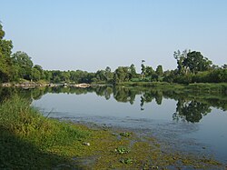
The Noyyal River is a small river in Western Tamil Nadu, and a tributary of Kaveri River. It rises from the Vellingiri hills in the Western Ghats in Tamil Nadu, very closer in proximity to Kerala border, and flows through many villages and the cities of Coimbatore, and Tirupur. Then finally, the river drains into the Kaveri River at Noyyal, a village in Karur district named after the river itself. The river's basin is 180 km (110 mi) long and 25 km (16 mi) wide and covers a total area of 3,500 km2 (1,400 sq mi). Cultivated land in the basin amounts to 1,800 km2 (690 sq mi) while the population density is 120 people per km2 (311/mi2) in the countryside, and 1000 people per km2 (2590/mi2) in the cities. The area is known for its scanty rainfall and the development of the Noyyal River Tanks System to hold any overflow from the rains plus the water of the Northeast and Southwest monsoon season was ecologically important. Kausika river, which originates along the northern side of Coimbatore district in the Western Ghats along with its consequent streams, lake and pond systems is an important tributary of the river. The 173 km (107 mi) long tributary of the Kaveri River filled 32 tanks. These interconnecting tanks held the water flowing from the Noyyal.

<span class="mw-page-title-main">Krishna Raja Sagara</span> Dam in Mandya, Karnataka

Krishna Raja Sagara, also popularly known as KRS, is a lake and the dam that creates it. They are close to the settlement of Krishna Raja Sagara in the Indian State of Karnataka. The gravity dam made of surki mortar is below the confluence of river Kaveri with its tributaries Hemavati and Lakshmana Tirtha, in the district of Mandya.

<span class="mw-page-title-main">Mettur</span> Town in Tamil Nadu, India

Mettur is an industrial and tourist town located in the Salem district in the state of Tamil Nadu, India. It is best known for the Mettur Dam which is the largest dam in south India.

<span class="mw-page-title-main">Palar River</span> River in southern India

Palar is a river of southern India. It rises in the Nandi Hills in Chikkaballapura district of Karnataka state, and flows 93 kilometres (58 mi) in Karnataka, 33 kilometres (21 mi) in Andhra Pradesh and 222 kilometres (138 mi) in Tamil Nadu before reaching its confluence into the Bay of Bengal at Vayalur about 75 kilometres (47 mi) south of Chennai. It flows as an underground river for a long distance only to emerge near Bethamangala town, from where, gathering water and speed, it flows eastward down the Deccan Plateau. The Towns of Bethamangala, Santhipuram, Kuppam,Mottur, Ramanaickenpet, Vaniyambadi, Ambur, Melpatti, Gudiyatham, Pallikonda, Anpoondi, Melmonavoor, Vellore, Katpadi, Melvisharam, Arcot, Ranipet, Walajapet, Kanchipuram, Walajabad, Chengalpattu, Kalpakkam, and Lattur are located on the banks of the Palar River. Of the seven tributaries, the chief tributary is the Cheyyar River.

<span class="mw-page-title-main">Bhavani River</span> River in India

Bhavani is an interstate Indian river which flows through Indian states of Kerala and Tamil Nadu, India. It originates from the Western Ghats and is one among the three rivers of Kerala which flows in eastward direction.

<span class="mw-page-title-main">Kallanai Dam</span> Dam in Tamil Nadu, India

Kallanai is an ancient dam built by Karikala of Chola dynasty in 150 CE. It is built across the Kaveri river flowing from Tiruchirapalli District to Thanjavur district, Tamil Nadu, India. The dam is located in Thanjavur district, 15 km from Tiruchirapalli and 45 km from Thanjavur. It is the fourth oldest water-diversion or water-regulator structure in the world and the oldest in India that is still in use. Because of its spectacular architecture, it is one of the prime tourist spots in Tamil Nadu.

<span class="mw-page-title-main">Stanley Reservoir</span> Reservoir in South India

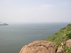
Stanley Reservoir located in Salem District of Tamil Nadu is one of largest fishing reservoirs in South India. It was completed in 1934 and was named after Lieutenant Colonel Sir George Frederick Stanley GCSI GCIE CMG, who served as the Governor of Madras from 1929 to 1934. Its main source of water is the River Kaveri (Cauvery). Three minor tributaries – Palar, Chennar and Thoppar – enter the Kaveri on its course above Stanley Reservoir. The water is retained by the Mettur Dam, Tamil Nadu.

<span class="mw-page-title-main">Kabini River</span> River in Kerala,South India, tributary of Kaveri and in Kerala

The Kabini River is one of the major tributaries of the river Cauvery in southern India. It originates near Kavilumpara in Kozhikode district of Kerala state by the confluence of the Panamaram River and the Mananthavady River. It flows eastward through Wayanad district, entering Mysore district of Karnataka, to join the Kaveri River in Mysore district of Karnataka.

<span class="mw-page-title-main">Mettur Dam</span> Dam in Tamil Nadu, India

The Mettur Dam is one of the largest dams in India and also the largest in Tamil Nadu, located across the river Kaveri where it enters the plains. Built in 1934, it took 9 years to complete. Maximum height and width of the dam are 214 and 171 feet, respectively. The dam receives inflows from its own catchment area, Kabini Dam and Krishna Raja Sagara Dams located in Karnataka. There is a park at the base of the dam called Ellis Park maintained by the Tamil Nadu Public Works Department. It provides irrigation and drinking water facilities for more than 12 districts of Tamil Nadu and hence is revered as the life and livelihood-giving asset of Tamil Nadu.

<span class="mw-page-title-main">Thamirabarani River</span> River in Tamil Nadu, India

The Thamirabarani or Tamraparni or Porunai is a perennial river that originates from the Agastyarkoodam peak of Pothigai hills of the Western Ghats, above Papanasam in the Ambasamudram taluk. It flows through Tirunelveli and Thoothukudi districts of the Tamil Nadu state of southern India into the Gulf of Mannar. It was called the Tamraparni River in the pre-classical period, a name it lent to the island of Sri Lanka. The old Tamil name of the river is Porunai. From the source to sea, the river is about 128 kilometres (80 mi) long and is the only perennial river in Tamil Nadu. This river flows towards north direction initially. However, it changes to east direction later.

<span class="mw-page-title-main">Nizam Sagar Dam</span> Dam in Telangana, India

Nizam Sagar Dam is an Indian dam named after the Nizam of Hyderabad. It is a reservoir constructed across the Manjira River, a tributary of the Godavari River, between Achampet and BanjePally villages of the Kamareddy district in Telangana, India. It is located at about 144 km (89 mi) north-west of Hyderabad. Nizam Sagar is the oldest dam in the state of Telangana.

<span class="mw-page-title-main">Hogenakkal Falls</span> Waterfall on Karnataka-Tamil Nadu border

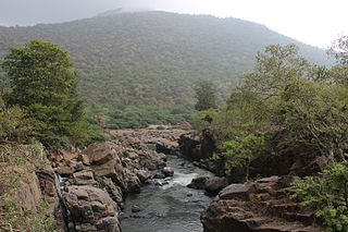
Hogenakkal Falls is a waterfall in South India on the Kaveri river on the border between Dharmapuri district of Tamil Nadu and Chamrajnagar district of Karnataka. It is located 46 km (29 mi) from Dharmapuri and 199 km (124 mi) from Chamrajnagar. Carbonatite rocks in this site are considered to be the oldest of its kind in South Asia and one of the oldest in the world. The Government of Tamil Nadu made a proposal to convert the falls into providing drinking water for the state.

<span class="mw-page-title-main">Shivanasamudra Falls</span> Waterfall in Karnataka, India

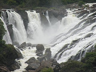
Shivanasamudra Falls is a cluster of waterfalls on the borders of Malavalli, Mandya and Kollegala, Chamarajanagara, in Karnataka, India, situated along the river Kaveri. The falls form the contour between the districts of Chamarajanagara and Mandya. The Bharachukki Falls in Kollegala, with a height of 69 metres, and the Gaganachukki Falls in Malavalli, with a height of 90 metres, collectively form the Shivanasamudra Falls.

<span class="mw-page-title-main">Hemavati River</span> River in India

The Hemavati is a river in southern India near Karnataka and an important tributary of the Kaveri.

<span class="mw-page-title-main">Kaveri River water dispute</span> Water conflict in India

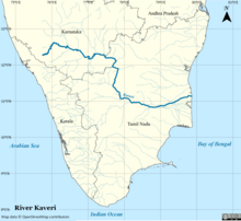
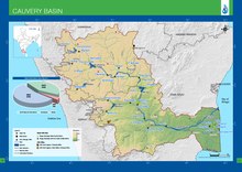
The sharing of waters of the Kaveri River has been the source of a serious conflict between the two Indian states of Tamil Nadu and Karnataka. The genesis of this conflict rests in two agreements in 1892 and 1924 between the Madras Presidency and Kingdom of Mysore. The 802 kilometres (498 mi) Kaveri river has 44,000 km2 basin area in Tamil Nadu and 32,000 km2 basin area in Karnataka. The annual inflow from Karnataka is 425 Tmcft (12 km3) whereas that from Tamil Nadu is 252 TMCft (7.1 km3).

<span class="mw-page-title-main">Veeranam Lake</span> Man-made lake in Tamil Nadu, India

Veeranarayanapuram Lake also Known as Veeranam Lake is located 14 km (8.7 mi) SSW in Cuddalore district in the state of Tamil Nadu in South India 1 km from Kattumannarkoil. It is located 235 km (146 mi) from Chennai, India. It is one of the water reservoirs from where water is supplied to Chennai city. The lake has a capacity to store about 1,465 mcft of water. Though the level in the Veeranam lake has dipped to 323 million cubic feet (mcft), the same amount of 180 mld was being drawn for supply to Chennai City.

<span class="mw-page-title-main">Hogenakkal Integrated Drinking Water Project</span> Fluorosis mitigation project in Tamil Nadu, India

Hogenakkal Integrated Drinking Water Project is a fluorosis mitigation drinking water project being undertaken at Hogenakkal, Dharmapuri district, state of Tamil Nadu, India. It is scheduled to be executed by Tamil Nadu Water Supply and Drainage Board (TWAD), with funding from Japan Bank for International Cooperation (JBIC) using Tamil Nadu's share of Cauvery river water. The project aims to supply safe drinking water to drought prone & fluorosis affected Dharmapuri and Krishnagiri districts of Tamil Nadu.

<span class="mw-page-title-main">Upper Anaicut</span> Dam in Tamil Nadu, India

The Upper Anaicut, also known as Mukkombu is a dam built on the Kaveri River in the state of Tamil Nadu in southern India. The regulator dam was constructed between 1836 and 1838 by Sir Arthur Cotton, a British irrigation engineer who was inspired by the architectural beauty of Grand Anaicut canal built by Karikala Chola in Kallanai of Thanjavur district in the second century.

<span class="mw-page-title-main">2018 Tamil Nadu protests for Kaveri water sharing</span> Dispute on Cauvery river water sharing

The 2018 Kaveri River water sharing protests are a series of ongoing protests on the issue of water sharing problems from the River Kaveri between Tamil Nadu and Karnataka which are two states in India. The Kaveri water dispute has been a major controversial issue between Tamil Nadu and Karnataka over the years and the issue has been raised further with protests have been conducted across the state of Tamil Nadu by several groups including from the large pile of actors and directors who have temporarily stopped working on their projects, films over the Karnataka's sharing the Kaveri water to Tamil Nadu. The delay in establishing a Cauvery Management Board in order to share equal river share award has sparked off protests in Tamil Nadu against the Karnataka state government.

<span class="mw-page-title-main">Palar River (Kaveri basin)</span> River

Palar is a river in the Indian states of Karnataka and Tamil Nadu. It originates near Guthiyalathur in Bhavani Taluk of Erode district in Tamil Nadu and forms border between Karnataka and Tamil Nadu. Later, it flows into the Kaveri River near Palar in Karnataka and Tamil Nadu.

References

  1. "INTEGRATED HYDROLOGICAL DATA BOOK" (PDF). Central Water Commission, India. p. 92. Archived from the original (PDF) on 2 April 2016. Retrieved 13 November 2017.
  2. 1 2 3 4 "River Discharge and Reservoir Storage Changes Using Satellite Microwave Radiometry - 2043".
  3. 1 2 "Gauging Station - Data Summary". RivDis. Archived from the original on 4 October 2013. Retrieved 1 October 2013.
  4. 1 2 3 4 5 "River Discharge and Reservoir Storage Changes Using Satellite Microwave Radiometry - 2042".
  5. 1 2 "Daughter of Ponni". indianexpress. 27 April 2014. Retrieved 27 April 2014.
  6. 1 2 "Cauvery Chronicles II: Ponni's Perish". newslaundry. Retrieved 8 February 2020.
  7. 1 2 "The death of a river". millenniumpost. 11 June 2019. Retrieved 11 June 2019.
  8. "Cauvery basin: its culture, places of historical significance, birth place, climate, precipitation, catchment, tributaries, state-wise spread, landuse". www.indiawaterportal.org. Retrieved 12 May 2020.
  9. "INTEGRATED HYDROLOGICAL DATA BOOK" (PDF). Archived from the original (PDF) on 24 September 2015. Retrieved 6 September 2012.
  10. 1 2 "World Waterfall Database". Archived from the original on 14 November 2006. Retrieved 9 November 2006.
  11. "Shivasamudram Falls". cauvery.com. Retrieved 11 November 2006.
  12. கணேசன், இரா (1974). அறிவியல் துறைச் சொல்லாக்க முறைகள் (in Tamil). புதுச்சேரி: இந்தியப் பல்கலைக்கழகத் தமிழாசிரியர் மன்ற ஆறாவது கருத்தரங்கு ஆய்வுக்கோவை, பாண்டிச்சேரி, தாகூர் அரசினர் கலைக்கல்லூரித் தமிழ்த்துறைச் சார்பு வெளியீடு. pp. 893, 895.
  13. "MW". www.sanskrit-lexicon.uni-koeln.de. Retrieved 18 July 2022.
  14. Blažek, Václav (2021). "Volha – řeka sedmi jmen". Linguistica Brunensia (1): 5–38. doi: 10.5817/lb2021-1-1 . ISSN   1803-7410. S2CID   239062051.
  15. 1 2 3 "Kaveri River | river, India | Britannica". www.britannica.com. Retrieved 15 February 2023.
  16. 1 2 3 4 Warrier, Shrikala (2014). Kamandalu: The Seven Sacred Rivers of Hinduism. Mayur University. pp. 20, 192–195. ISBN   9780953567973.
  17. 1 2 3 4 Ramkumar, Mu; Kumaraswamy, K.; Mohanraj, R. (2015). Environmental Management of River Basin Ecosystems. Springer. p. 286.
  18. 1 2 3 Jain, Sharad K.; Agarwal, Pushpendra K.; Singh, Vijay P. (2007). Hydrology and Water Resources of India. Springer Science. pp. 702–711. ISBN   9781402051807.
  19. 1 2 3 4 5 Singh, Dhruv Sen (2018). The Indian rivers : scientific and socio-economic aspects. Singapore: Springer Hydrogeology. pp. 354–356.
  20. Nagendra, R.; Nallapa Reddy, A. (1 January 2017). "Major geologic events of the Cauvery Basin, India and their correlation with global signatures – A review". Journal of Palaeogeography. 6 (1): 69–83. doi: 10.1016/j.jop.2016.09.002 .
  21. Subrahmanya, K. R.; Prakash Narasimha, K. N. (October 2017). "Kaveri crater – An impact structure in the Precambrian terrain of southern India". Journal of the Geological Society of India. 90 (4): 387–395. doi:10.1007/s12594-017-0733-5. ISSN   0016-7622. S2CID   134717819.
  22. 1 2 Sunil, C.; Somashekar, R. K.; Nagaraja, B. C. (1 November 2010). "Riparian vegetation assessment of Cauvery River Basin of South India". Environmental Monitoring and Assessment. 170 (1): 548. doi:10.1007/s10661-009-1256-3. PMID   20024615. S2CID   19865294.
  23. "Ranganathittu Bird Sanctuary | Ramsar Sites Information Service". rsis.ramsar.org. Retrieved 18 February 2023.
  24. Eck, Diana L. (2012). India: A Sacred Geography. United States: Harmony Books. p. 179. ISBN   9780385531917.
  25. "Chapter 26: Irrigation and power". 1st Five Year Plan. Planning Commission, Government of India. Archived from the original on 28 March 2019. Retrieved 1 July 2019.
  26. "Archived copy" (PDF). www.tce.co.in. Archived from the original (PDF) on 20 March 2007. Retrieved 13 January 2022.{{cite web}}: CS1 maint: archived copy as title (link)
  27. "Corporation urged to chalk out water policy for Mysore city". The Hindu . Chennai, India. 26 March 2006. Archived from the original on 29 October 2006.
  28. 1 2 "Cauvery reservoirs' inflow hits record low". Deccan Herald. Bangalore. 2 August 2003. Archived from the original on 6 April 2012. Retrieved 18 March 2011.
  29. "TN assembly passes bill to declare Cauvery Delta as Protected Agricultural Zone". The Week .
  30. 1 2 Rani, Midatala; Rani, Middatala (2002). "Historical Background Of The Cauvery Water Dispute". Proceedings of the Indian History Congress. 63: 1033–1042. JSTOR   44158173 via JSTOR.
  31. "Archived copy" (PDF). Archived from the original (PDF) on 17 April 2018. Retrieved 24 July 2018.{{cite web}}: CS1 maint: archived copy as title (link)
  32. "Judgement Copy- SC verdict on Cauvery water dispute". Scribd.
  33. "Cauvery Water Management Scheme, 2018". Department of Water Resources, RD & GR.
  34. Rajagopal, Krishnadas (16 February 2018). "Supreme Court curtails Tamil Nadu's share of Cauvery water". The Hindu. ISSN   0971-751X . Retrieved 2 December 2019.
  35. "Cauvery dispute". www.thenewsminute.com. 23 June 2018. Retrieved 2 December 2019.