Related Research Articles

The Mahanadi River is a major river in East Central India. It is the longest earthen dam in the world. It drains an area of around 132,100 square kilometres (51,000 sq mi) and has a total length of 900 kilometres (560 mi). Mahanadi is also known for the Hirakud Dam which was the first major multipurpose river valley project after India's independence in 1947. The river flows through the states of Chhattisgarh and Odisha and before finally ending in the Bay of Bengal.

The Brahmani is a major seasonal river in the Odisha state of eastern India. The Brahmani is formed by the confluence of the Sankh and South Koel rivers, and flows through the districts of Sundargarh, Deogarh, Angul, Dhenkanal, Cuttack, Jajapur and Kendrapara. Also South Koel can be considered as upper reaches of Brahmani. Together with the river Baitarani, Brahmani forms a large delta before emptying into the Bay of Bengal at Dhamra. It is the second widest river in Odisha after Mahanadi.
Indravati River is a tributary of the Godavari River, in central India.
Mahasamund is a city in Mahasamund District in the Indian state of Chhattisgarh.It is situated on the Mumbai-Kolkata and Raipur-Vishakhaptnam National Highways. It is one of the largest and most important cities in the State. The city is divided into 30 wards and 5 zones and is also the biggest city in the Trans-Mahanadi area. It is also the administrative headquarters of the Mahasamund District and part of the proposed new Mahasamund Municipal Corporation. The current mayor is Prakash Chandrakar. Reliance Trends, Vishal Megamart, Reliance Jio Smart Point, B mart and Zee Sale are prominent Shopping Centers of the City.

Bamra State or Bamanda State, covering an area of 5149 km2, was one of the princely states of India during the period of the British Raj, its capital was in Debagarh (Deogarh). Bamra State acceded to India in 1948.

Hirakud Dam is built across the Mahanadi River, about 15 kilometres (9 mi) from Sambalpur in the state of Odisha in India. It is the longest earthen dam in the world. Behind the dam extends a lake, Hirakud Reservoir, 55 km (34 mi) long. It is one of the first major multipurpose river valley projects started after India's independence. Hirakud Reservoir was declared a Ramsar site on 12 October 2021.
Brajrajnagar is a town and a municipality in Jharsuguda district in the state of Odisha, India. Popular legend says the town was named after Braj Mohan Birla after he setup Orient Paper Mills in 1936. It's a small sleepy town on rocky terrain, built on the banks of IB river, with temples mostly built by the Birlas. Later it became famous for MCL-owned coal mines after Orient Paper Mills of Birlas closed down in 1999.
Champua is a notified area council in Kendujhar district in the state of Odisha, India.As per SC & ST department of Odisha, the Champua sub-division is under scheduled areas of Odisha. Nicholson Forest training institute is present here. The suburb has its importance as it provides a major trade route for transport of iron ore and manganese from some of the major mines of the state to the nearest port & out-state depots. It is also known for its pre-independence truss bridge built by British rulers, the judicial buildings of the same period as well as a few educational institutes who have a good reputation in the state. The river Baitarani flows by Champua, which is one of the largest rivers of the state second only to Mahanadi.
Khariar Road is a city in India. It is located at Odisha-Chhattisgarh border. It is 120 km (75 mi) from Raipur, capital of Chhattisgarh and is one of the fastest growing economic centers of India. It is also one of the key railway stations of the East Coast Railway.
Shivrinarayan also known as Sheorinarayan is a town and a nagar panchayat located at the Triveni Dhara of Mahanadi, Shivnath and Jonk River in Janjgir-Champa district in the Indian state of Chhattisgarh.

Mahasamund district is a district in Chhattisgarh state in central India. The city of Mahasamund is the district headquarters. The district is particularly famous for the historical temple town of Sirpur besides the Mahanadi river.
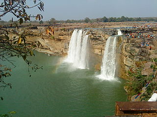
The Tel river flows in Nabarangpur, Kalahandi, Balangir, Boudh Sonepur District of Odisha, India. Tel is an important tributary of Mahanadi. It flows just eight kilometers away from the town of Titilagarh. This significant tributary of the Mahanadi river meets the main river at Sonepur or Subarnapur. The convergence of the two rivers offers a remarkable view against a colorful landscape. Baidyanath temple, which is famous for the Kosaleshwar Shiva temple, is located on the left bank of the Tel River.

Odisha is one of the 28 states in the Republic of India. Odisha is located in the eastern part of the Indian peninsula and the Bay of Bengal lies to its East while Chhattisgarh shares its border in the west and north-west. The state also shares geographic boundaries with West Bengal in the north-east, Jharkhand in the north and Andhra Pradesh in the south. The state is spread over an area of 1,55,707 km2 and extends for 700 km from north to south and 500 kilometres from east to west. Its coastline is 450 km long. The state is divided into 30 districts which are further subdivided into 314 blocks.

Hasdeo River is the largest tributary of Mahanadi River. The river flows in the state of Chhattisgarh. It joins Mahanadi River near Shiladehi (Birra). Hasdeo Bango Dam is constructed across this river. The river originates about 910.0 m above sea level, in a place about 10.0 km from Sonhat in Koriya district. The total length of the river is 333.0 km, and drainage area is 9856 km2. The major tributary of Hasdeo River is Gej River. The river flows through the Hasdeo Arand forest.

Shivnath River is the longest tributary of theMahanadi River, which joins Changori in the Janjgir-Champa district in Chhattisgarh, India. It has a total course of 290 kilometres (180 mi). The name comes from the god Shiva in Hinduism.
The Mand River is a tributary of the Mahanadi in India. It joins the Mahanadi in Chandarpur, in Chhattisgarh, 28 km from the Odisha border and before the river reaches the Hirakud Dam.

Ib river is tributary of Mahanadi river in North-Eastern Central India. It joins Mahanadi river flowing directly into the Hirakud Reservoir. The river originates in hills near Pandrapet at an elevation of 762 metres (2,500 ft). It passes through Raigarh district and Jashpur district of Chhattisgarh and Jharsuguda and Sundargarh District of Odisha and finally meets Mahanadi at Hirakud Dam in the state.

Sri Nilamadhava Temple is very old and famous Lord Vishnu temple which is near to the bank of Mahanadi, in Kantilo, Odisha, India. It is present near to the twin hills with a surrounding forest. A permanent flow of holy water from the feet of Lord Nilamadhava is another attraction of the spot. Lord Siddheswar is also present which is another highlight of the place.
Ib Valley Coalfield is located in Jharsuguda district in the Indian state of Odisha, in the valley of the Ib River, a tributary of the Mahanadi. ′

The Garhjat Hills is a mountain range formed by a series low-lying hills, plateaux, ridges and meadows that stretch into Odisha from the Utkal Plains in the Chotanagpur region of Jharkhand and the Chhattisgarh Plains. The range, also known as the Odisha Highlands, runs in a north east to south west direction for about 382 km along the Odisha coast, covering 76,800 km2 (29,700 sq mi).
References
- ↑ Padhan, Tosabanta (25 November 2014). "Stone Age Archaeology of Jonk River Basin in Western Odisha and Eastern Chhattisgarh". Postdoctoral thesis. Deccan College Post-Graduate and Research Institute . Retrieved 27 August 2015.
- ↑ Cultural profile of south Kōśala by Jitāmitra Prasāda Sim̄hadeba, J. Prasad Singh Deo