The Kaveri is one of the major Indian rivers flowing through the states of Karnataka and Tamil Nadu. The Kaveri River rises at Talakaveri in the Brahmagiri range in the Western Ghats, Kodagu district of the state of Karnataka, at an elevation of 1,341 m above mean sea level and flows for about 800 km before its outfall into the Bay of Bengal. It reaches the sea in Poompuhar, in Mayiladuthurai district. It is the third largest river – after Godavari and Krishna – in southern India, and the largest in the state of Tamil Nadu, which, on its course, bisects the state into north and south. In ancient Tamil literature, the river was also called Ponni.

Erode District is one of the 38 districts in the south Indian state of Tamil Nadu. It was the largest district by area in the state before the formation of Tirupur district in 2009 and is the third largest by area, as of 2024. The headquarters of the district is Erode. The district is divided into two revenue divisions, Erode and Gobichettipalayam, and is further subdivided into 10 taluks.

Palakkad is one of the 14 districts in the Indian state of Kerala. It was carved out of the southeastern region of the former Malabar District on 1 January 1957. It is located at the central region of Kerala and is the second largest district in the state after Idukki. The city of Palakkad is the district headquarters. Palakkad is bordered on the northwest by the Malappuram district, on the southwest by the Thrissur district, on the northeast by Nilgiris district, and on the east by Coimbatore district of Tamil Nadu. The district is nicknamed "The granary of Kerala". Palakkad is the gateway to Kerala due to the presence of the Palakkad Gap, in the Western Ghats. The 2,383 m high Anginda peak, which is situated in the border of Palakkad district, Nilgiris district, and Malappuram district, in Silent Valley National Park, is the highest point of elevation in Palakkad district. Palakkad city is about 347 kilometres (216 mi) northeast of the state capital, Thiruvananthapuram.

The Noyyal River is a small river in Western Tamil Nadu, and a tributary of Kaveri River. It rises from the Vellingiri hills in the Western Ghats in Tamil Nadu, very closer in proximity to Kerala border, and flows through many villages and the cities of Coimbatore, and Tirupur. Then finally, the river drains into the Kaveri River at Noyyal, a village in Karur district named after the river itself. The river's basin is 180 km (110 mi) long and 25 km (16 mi) wide and covers a total area of 3,500 km2 (1,400 sq mi). Cultivated land in the basin amounts to 1,800 km2 (690 sq mi) while the population density is 120 people per km2 (311/mi2) in the countryside, and 1000 people per km2 (2590/mi2) in the cities. The area is known for its scanty rainfall and the development of the Noyyal River Tanks System to hold any overflow from the rains plus the water of the Northeast and Southwest monsoon season was ecologically important. Kausika river, which originates along the northern side of Coimbatore district in the Western Ghats along with its consequent streams, lake and pond systems is an important tributary of the river. The 173 km (107 mi) long tributary of the Kaveri River filled 32 tanks. These interconnecting tanks held the water flowing from the Noyyal.

Sathyamangalam is a town and municipality in Erode district in the Indian state of Tamil Nadu. It lies on the banks of the Bhavani river, a tributary of the Cauvery in the foothills of the Western Ghats and is the headquarters of Sathyamangalam taluk. It is about 65 km from Erode, 58 km from Tiruppur and 65 km from Coimbatore. As of 2011, the town had a population of 37,816.

Erode, is a city in the Indian state of Tamil Nadu. It is located on the banks of the Kaveri river and is surrounded by the Western Ghats. Erode is the seventh largest urban agglomeration in Tamil Nadu. It is the administrative capital of Erode district and is administered by the Erode Municipal Corporation which was established in 2008.

Mettur is an industrial and tourist town located in the Salem district in the state of Tamil Nadu, India. It is best known for the Mettur Dam which is the largest dam in south India.

The Bhavani is an interstate Indian river which flows through Indian states of Kerala and Tamil Nadu, India. It originates from the Western Ghats and is one among the three rivers of Kerala which flows in eastward direction.

Bhavani is a Municipality in Erode District, Tamil Nadu, India. It is located at the northern periphery of Erode City Municipal Corporation and is around 105 km (65 mi) from Coimbatore and 60 km (37 mi) from Tiruppur and Salem. Bhavani is also known as "Carpet City" as it is known for its carpet industry; blankets and carpets manufactured in the town are known as Bhavani Jamakkalam. As of 2011, the town covers an area of 2.17 square kilometres (0.84 sq mi) and has a population of 39,225. It is a grade II municipality.

Palakkad Gap or Palghat Gap is a low mountain pass in the Western Ghats between Coimbatore in the Indian state of Tamil Nadu and Palakkad in the state of Kerala. It has an average elevation of 140 metres (460 ft) with a width of 24–30 kilometres (15–19 mi). The pass is located between the Nilgiri Hills to the north and Anaimalai Hills to the south.

The Anamala or Anaimalai, also known as the Elephant Mountains, are a range of mountains in the southern Western Ghats of central Kerala and span the border of western Tamil Nadu in Southern India. The name anamala is derived from the Malayalam word aana and the Tamil word yaanai, meaning elephant, or from tribal languages. Mala or Malai means 'mountain', and thus literally translatable as 'Elephant mountain'.

Coimbatore district is one of the 38 districts in the state of Tamil Nadu in India. Coimbatore is the administrative headquarters of the district. It is one of the most industrialized districts and a major textile, industrial, commercial, educational, information technology, healthcare and manufacturing hub of Tamil Nadu. The region is bounded by Tiruppur district in the east, Nilgiris district in the north, Erode district in the northeast, Palakkad district, Idukki district and small parts of Thrissur district and Ernakulam district of neighboring state of Kerala in the west and south respectively. As of 2011, Coimbatore district had a population of 3,458,045 with a sex ratio of 1,000 and literacy rate of 84%.

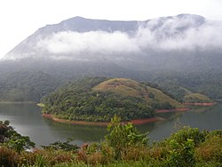
Parambikulam Dam is an embankment dam on the Parambikulam River, located in the Palakkad district in the Western Ghats of Kerala, India, ranks number one in India as well as in the top ten embankment dams in the world in volume in the year 2000.
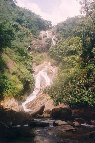
Siruvani Waterfalls is located 36 km (22 mi) west of Coimbatore in the Western Ghats in India. The reservoir at Siruvani was built by the Indian government for Tamil Nadu, and funded by the Tamil Nadu government, to meet the drinking water requirements of Coimbatore. The gateways on either side of the road across the dam showcase typical Kerala and Tamil architectural styles. Siruvani is also home to indigenous tribes like the Mudugar and Irulas.
Bhavani is a Hindu goddess, a ferocious aspect of Parvati.

Coimbatore is the second largest city in the Indian state of Tamil Nadu. It is situated in the western corner of Tamil Nadu, a short distance from the border with the neighbouring state of Kerala, and is surrounded by the Western Ghats on all sides.

Tamil Nadu-Kerala dam row is an ongoing row and the long legal battle between the Indian states of Tamil Nadu and Kerala about the Mullaperiyar Dam on the Periyar river. Although the 127-year-old Mullaperiyar dam is located in Kerala, it is operated by the government of Tamil Nadu which signed a 999-year lease agreement with the former British government to irrigate farmland on its side. The agreement was signed by the Secretary of Madras State under the British Raj and the King of Travancore. From several technical surveys conducted, Kerala states the old masonry dam built with lime surkhi mortar is structurally getting weaker and costly in leakage and massive cracks - shear maintenance in abutments above all poses a significant danger to an approximate 3 million people living in the region and that it needs to be rebuilt – a move opposed by Tamil Nadu. Tamil Nadu maintains that the endangered dam was repaired in 1979 and insists the dam's walls have been strengthened and that it can hold more water than the current level of 136 ft and also due to the fact it only takes around 25,000 INR per year payment for an estimated usage of water for 8000 acres per British oppression era lease, this does not include how many tmc feet could be shared which is also a blissful loophole in the Mullayar-"Periyar Lease Deed of 1886" that the government is unwilling to waive. In a 1998 affidavit, the Tamil Nadu government admitted that it drew around 21 tmc ft or 594636000000 L annually for around 230,000 acres. Although the Periyar River has a total catchment area of 5398 km2 with 114 km2 downstream from the dam in Tamil Nadu, the catchment area of Mullaperiyar Dam itself lies entirely in Kerala and thus its water source is not an inter-State river.
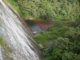
Siruvani dam is a dam in Palakkad District, Kerala located 46 km away from Palakkad town. This dam constructed across the Siruvani River, is for supplying drinking water to the city of Coimbatore in Tamil Nadu. The dam is surrounded by reserve forests. Muthikulam hill is situated on the eastern side of the dam. There is a natural waterfall in the hill. The waterfalls and the Dam are big tourist attractions. The famous 150-year-old Pattiyar Bungalow is on the banks of the Siruvani Reservoir. An agreement was executed in August 1973 between the state Governments for drinking water supply to Coimbatore town and neighbouring areas from the Siruvani Dam. The location being in the state of Kerala, the project was executed by the Kerala Public Works Department using the funds made available by the Tamil Nadu Government. The gross storage capacity of the dam is 9 tmc ft
Kalingarayan Anicut is a barrage on the Bhavani river in Erode district, Tamil Nadu. It is located before Kooduthurai where Bhavani meets with Kaveri in Bhavani, Erode.
Palar is a river in the Indian states of Karnataka and Tamil Nadu. It originates near Guthiyalathur in Bhavani Taluk of Erode district in Tamil Nadu and forms border between Karnataka and Tamil Nadu. Later, it flows into the Kaveri River near Palar in Karnataka and Tamil Nadu.