Dharmapuri

Last updated

Dharmapuri
Thagadur
Aerial view dharmapuri.jpg
Aerial view of mid city
Nickname(s): 
Thagadoor, Dharmapuri
India Tamil Nadu location map.svg
Red pog.svg
Dharmapuri
Dharmapuri (Tamil Nadu)
India location map 3.png
Red pog.svg
Dharmapuri
Dharmapuri (India)
Coordinates: 12°07′16″N78°09′30″E / 12.121100°N 78.158200°E / 12.121100; 78.158200
Country Flag of India.svg  India
State TamilNadu Logo.svg Tamil Nadu
District Dharmapuri
Established3rd Century BC
Founded by The King Adhiyaman
Government
  TypeSpecial Grade Municipality
  BodyDharmapuri Municipality
Area
  Total25.32 km2 (9.78 sq mi)
  Rank9
Elevation
482 m (1,581 ft)
Population
 (2017)
  Total113,218
  Density4,500/km2 (12,000/sq mi)
Languages
  Official Tamil
Time zone UTC+5:30 (IST)
PIN
636(7xx),636(8xx)
Telephone code4342
Vehicle registration TN-29
Website www.dharmapuri.nic.in

Dharmapuri is a city in the north western part of Tamil Nadu, India. It serves as the administrative headquarters of Dharmapuri district which is the first district created in Tamil Nadu after the independence of India by splitting it from then Salem district on 2 October 1965. The city is located 50 km from Krishnagiri, 69 km from Salem, 60 km from Tirupattur, 90 km from Hosur, 117 km from Thiruvannamalai, 126 km from Bangalore and Erode, 181 km from Tiruppur, 200 km from Coimbatore and Tiruchirappalli, 300 km from Madurai and the state capital Chennai. It is located between latitudes N 11 47’ and 12 33’ and longitudes E 77 02’ and 78 40’. It is one of the major leading cultivators and producers of mangoes in the state along with Krishnagiri, and is often referred as Mango Capital of India.

Contents

History

Dharmapuri was called Thagadoor where King Adhiyamaan ruled. Adhiyaman Kottai is situated near Dharmapuri-Salem highway. Many temples were built during Adhiyamaan's rule. There is a tunnel from Adhiyamaan kottai temple to Dharmapuri Kottai temple.

The region is believed to have been controlled by the Pallava dynasty in the 8th century. The Rashtrakutas took over in the 9th century. They were defeated by the Cholas in the 11th century, and subsequently the district came under the Chola sphere of governance.[2]

During 18th century present day Dharmapuri district was part of the Kingdom of Mysore and was called Baramahal. As part of the Treaty of Seringapatam (signed on 18 March 1792) after the Third Anglo-Mysore War, Tipu Sultan agreed to give part of his territories including present-day Dharmapuri district to the British East India Company which was then merged into the Madras Presidency an administrative subdivision of British India.

It was part of the salem District under British rule, until the founding of Dharmapuri district on 2 October 1965. The Dharmapuri district was split into Dharmapuri and Krishnagiri districts in 2004.[2] Many historical rock sculptures are found in this district. Modhur, a village near Dharmapuri has remains that date back to the Neolithic age. A government museum in Dharmapuri city displays some of these significant sculptures.

Geography

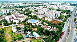
Dharmapuri is situated in the northwestern corner of Tamil Nadu and is bounded by the Eastern Ghats to the east, Nallampalli taluk to the South, Palacode taluk to the north, and the Pennagaram taluk to the west. It is located between latitudes N 11 47’ and 12 33’ and longitudes E 77 02’ and 78 40’. It is 300 km from Chennai city and 130 km from Bangalore. All the corporations in Tamil Nadu except Sivakasi, Nagercoil, Thoothukudi and Tirunelveli lies within 300 km from Dharmapuri. Cities from neighboring states like Bangalore, Mysore, Tumkur, Chittoor, Tirupathi, Thrissur, Palakkad, Salem, Puducherry also lie within a 300 km radius. Dharmapuri is located on a geographically important area in South India. [1]

Climate

Dharmapuri has a tropical wet and dry climate (Köppen Aw). The summer period of March, April, May, and June is sweltering and dry, reaching a maximum temperature of up to 38 °C or 100.4 °F. The temperatures drop in December and the low temperatures continue up to February, touching a minimum of 14 °C or 57.2 °F in January. The district has an average annual rainfall of 910 millimetres or 35.83 inches. The tropical forests here generally have short shrubs and thorned plants. [2]

Climate data for Dharmapuri (1981–2010, extremes 1975–2012)
MonthJanFebMarAprMayJunJulAugSepOctNovDecYear
Record high °C (°F)34.2
(93.6)
37.8
(100.0)
40.0
(104.0)
41.0
(105.8)
41.4
(106.5)
40.0
(104.0)
41.0
(105.8)
38.0
(100.4)
37.6
(99.7)
35.0
(95.0)
33.7
(92.7)
33.8
(92.8)
41.4
(106.5)
Mean daily maximum °C (°F)29.5
(85.1)
32.7
(90.9)
35.6
(96.1)
37.0
(98.6)
36.6
(97.9)
34.2
(93.6)
33.3
(91.9)
32.6
(90.7)
32.4
(90.3)
30.8
(87.4)
29.0
(84.2)
28.0
(82.4)
32.6
(90.7)
Mean daily minimum °C (°F)17.7
(63.9)
18.7
(65.7)
20.8
(69.4)
23.8
(74.8)
24.4
(75.9)
23.8
(74.8)
23.4
(74.1)
23.0
(73.4)
22.6
(72.7)
21.8
(71.2)
20.1
(68.2)
18.3
(64.9)
21.5
(70.7)
Record low °C (°F)10.6
(51.1)
11.0
(51.8)
14.2
(57.6)
17.0
(62.6)
18.2
(64.8)
20.0
(68.0)
18.9
(66.0)
15.5
(59.9)
17.7
(63.9)
12.9
(55.2)
13.0
(55.4)
10.9
(51.6)
10.6
(51.1)
Average rainfall mm (inches)5.0
(0.20)
3.8
(0.15)
22.5
(0.89)
44.2
(1.74)
96.7
(3.81)
70.0
(2.76)
75.6
(2.98)
105.5
(4.15)
170.5
(6.71)
181.5
(7.15)
93.8
(3.69)
41.5
(1.63)
910.6
(35.86)
Average rainy days0.50.31.32.56.03.84.86.08.09.35.92.851.2
Average relative humidity (%) (at 17:30 IST)50393238465154556068676052
Source: India Meteorological Department [3] [4]

Demographics

Religious census
ReligionPercent(%)
Hindu
88.99%
Muslim
9.65%
Christian
0.99%
Sikh
0.02%
Buddhist
0.01%
Jain
0.01%
Other
0.33%

According to the 2011 census, Dharmapuri had a population of 113,218 with a sex-ratio of 1,013 females for every 1,000 males, much above the national average of 929. [5] A total of 6,759 were under the age of six, constituting 3,470 males and 3,289 females. Scheduled Castes and Scheduled Tribes accounted for 6.92% and 0.14% of the population respectively. The average literacy of the town was 77.08%, compared to the national average of 72.99%. [5] The town had a total of 17,136 households. There were a total of 26,943 workers, comprising 606 cultivators, 427 main agricultural laborers, 1,052 in household industries, 22,566 other workers, 2,292 marginal workers, 54 marginal cultivators, 77 marginal agricultural laborers, 213 marginal workers in household industries and 1,948 other marginal workers. [6]

As per the religious census of 2011, Dharmapuri (M) had 88.99% Hindus, 9.65% Muslims, 0.99% Christians, 0.02% Sikhs, 0.01% Buddhists, 0.01% Jains and 0.33% following other religions. [7]

Politics

It is part of the Dharmapuri (state assembly constituency) and Dharmapuri (Lok Sabha constituency). The Member of Lok Sabha is S. Senthilkumar (Dharmapuri).

Transport

Roadways

Dharmapuri is well connected by major National highway NH-44. Commonly called north–south corridor which originates from Srinagar and terminates at Kanyakumari passes through the district. Another highway it encompasses is NH-844 which originates from Adhiyamankottai in Dharmapuri and terminates at Neraluru village near Chandrapura,Bengaluru. State highways like SH-60 (Hogenakkal-Pennagaram-Dharmapuri-Tirupattur), & SH-60A(Dharmapuri-Harur) via Morappur also passes through the city.The Dharmapuri-Harur section and Thanipadi-Thiruvannamalai section of SH-60A is currently being widened to four lane roads providing an alternative route to major cities like Puducherry and Villupuram via Thiruvannamalai from Dharmapuri.

Railways

Dharmapuri railway station (DPJ) is situated 1.6 kilometer from Dharmapuri bus stand. The station was fractured to South Western Railways when they reformed it. Now it is under the Bangalore railway division. The railway station currently has one functional line, the Bengaluru–Dharmapuri–Salem line. The other line, Dharmapuri–Morappur line, which was constructed in 1907 functioned for about 38 years and was removed by the Indian government. However again the line is under construction with electrification due to the necessity of the people in the district. This new line will connect the people of Dharmapuri district to Chennai directly. As well as this line is the alternative route for Bangalore–Chennai (via Dharmapuri). Dharmapuri has two more important railway stations viz. Morappur (MAP) and Bommidi (BQI) which comes under Southern Railway Salem Division. These stations connects Chennai and Coimbatore through Katpadi, Jolarpettai Junction railway station, Salem, Erode Junctions,

Airways

The nearest airport, Salem airport, is located in Salem at a distance of 45 kilometres (28 mi) and nearest International airport is Kempegowda International Airport, located in Devanahalli, near Bengaluru (Bangalore), at a distance of 155 kilometres (96 mi).

Related Research Articles

<span class="mw-page-title-main">Krishnagiri district</span> District in Tamil Nadu, India

Krishnagiri district is one of the 38 districts of the state of Tamil Nadu, in India. This district is carved out from Dharmapuri District by 2004. The municipal town of Krishnagiri is the district headquarters. In Tamil Nadu, e-Governance was first introduced at Krishnagiri district under the National e-Governance Project (NEGP) in revenue and social welfare departments on a pilot basis. The district is one of the largest producers of mangoes in India. As of 2011, the district had a population of 1,879,809 with a sex-ratio of 958 females for every 1,000 males. Hosur is the most populous town in the district.

<span class="mw-page-title-main">Ambur</span> Municipal Town in Tamil Nadu, India

Ambur is a town and municipality in newly announced Tirupathur district, Vellore region of Tamil Nadu, India. It is located on the banks of the Palar River between Chennai and Bangalore. Ambur has a sizeable leather industry, and is known for its spicy biryani and for the sweet, makkhenpeda. Ambur was the site of two major military actions in the 18th century. The first was the 1749 Battle of Ambur that opened the Second Carnatic War between the Arcot State and the Mughal Empire. In 1767, the siege of Ambur took place during the First Anglo-Mysore War, with local troops and a British force successfully resisting an attack by the Kingdom of Mysore and by the Hyderabad State.

<span class="mw-page-title-main">Dharmapuri district</span> Place in India

Dharmapuri is one of the 38 districts in the state of Tamil-Nadu, India. It is the first district created in Tamil Nadu after the independence of India by splitting it from then-Salem district on 2 October 1965. Dharmapuri District is one of the major producers of mango in the state, fine quality granite is found in the district. It is also one of the main sericulture belts in the state. Around 30 percent of the district's area is under forest cover. Kaveri enters Tamil Nadu through this district. Dharmapuri district had the lowest literacy rate of 74.23% in Tamilnadu during the 2011 census.

Chengam is an important market town and a taluk headquarter in the Foot hills of Eastern ghats in Tiruvannamalai district of Tamil Nadu, India. Chengam is the gateway to the Chengam pass in the Eastern ghats between Javvadhu hills to the north and Chennakesava hills to the south. The town is also the center for various industrial activities which includes Sathanur dam hydro-electric project, Aavin milk processing plant and Periya Kolappadi SIDCO estate.

Harur is a third grade municipality in the Dharmapuri district of Tamil Nadu, India. It is one of two revenue blocks in the district.

Kadathur is a panchayat town in Dharmapuri district in the Indian state of Tamil Nadu. Kadathur is situated 20 kilometres (12 mi) southeast of Dharmapuri. It is in the southern region of the district.

Kambainallur is a panchayat town in karimangalam taluk of Dharmapuri district in the Indian state of Tamil Nadu. It also serves as a main source of transport, food, health and education for many villages situated around the Kambainallur.

Pennagaram is a town in Dharmapuri district in the Indian state of Tamil Nadu. It is the headquarters of Pennagaram taluk (sub-district).

<span class="mw-page-title-main">Krishnagiri</span> City in Tamil Nadu, India

Krishnagiri is a city in the state of Tamil Nadu, India, and it serves as the administrative headquarters of Krishnagiri District formed in 2004. It is located at the bottom of Krishnadevaraya Hills, and the town is fully surrounded by hill rocks. It is located 250 km from Chennai, 45 km from Dharmapuri, and 90 km from Bengaluru. Krishnagiri is known as "Mango Capital of India" as mangoes are cultivated as the main crop, and the land here is extremely fertile with rich access to fresh water making it amenable to growing crops. Krishnagiri is the site of significant business and residential development. The Krishnagiri Dam was built in 1967.

<span class="mw-page-title-main">Periyar University</span> Public University in Salem district

Periyar University is a university in Salem, Tamil Nadu, India. It was established by the Government of Tamil Nadu in 1997. It is named after social reformer Thanthai Periyar E. V. Ramasamy. The University Grants Commissions, New Delhi bestowed 2f status in 1998 and 12(B) status in 2005 to the university. It is accredited by NAAC with 'A++' grade. It has been awarded a cumulative grade point average (CGPA) of 3.61 out of 4 points. University ranked Second in India only after to Mumbai University and First in Tamil Nadu among State Universities. Periyar University is the first State University to rank "A++" grade.

Singarapettai is a town in Krishnagiri district in Tamil Nadu. In the 2011 census it had a population of 2253 in 537 households.

<span class="mw-page-title-main">Hosur</span> Industrial city in Tamil Nadu, India

Hosur is an industrial city located in Krishnagiri district in the Tamil Nadu state of India. Hosur is one of the 21 municipal corporations in Tamil Nadu. It is located on the bank of the river River Ponnaiyar, 40 kilometres (25 mi) southeast of Bengaluru and 306 kilometres (190 mi) west of Chennai, the state capital. Hosur is home to major manufacturing industries including Stellantis, Ashok Leyland, Titan, TVS Motors, Caterpillar, Ather Energy, Schaeffler, and many others.

Bommidi is a panchayat town which is located in Pappireddipatti taluka of Dharmapuri district in Tamil Nadu, India. It is also known as B. Mallapuram. Bommidi's name is used for the railway station, the police station situated at Nadur, the post office, and bus transportation, while the name "B. Mallapuram" is used for schools, hospitals, and government officials.

Tirupathur taluk is a taluk in Tirupathur district of the Indian state of Tamil Nadu. The headquarters of the taluk is the town of Tirupathur. It is known as the "Sandalwood Town" due to the abundant availability of sandalwood trees in the surrounding hills. On 15 August 2019, Chief Minister of Tamil Nadu, Edapaadi K. Palanisami announced Tirupathur district, as a new district of Tamil Nadu.

Dharmapuri railway station is situated in the central part of Dharmapuri City, which is the headquarters of the Dharmapuri district of Tamil Nadu. It has been administered by the South Western Railway zone, included in the Bangalore railway division that was transferred over from the Southern Railway zone. It is one of the main halts in northwest Tamil Nadu. Every train passing through this route has a stop here.

Kammalampatty village is located in Harur Taluk of Dharmapuri district in Tamil Nadu, India. It is situated 5 km away from sub-district headquarter Harur and 46 km away from district headquarter Dharmapuri. As per 2009 stats, Ellapudayampatty is the gram panchayat of Kammalampatty village.

<span class="mw-page-title-main">Tirupattur</span> Town in Tamil Nadu, India

Tirupathur or Tirupattur is the headquarters of Tirupathur district in the state of Tamil Nadu in India and is one of the oldest inhabited places in the state, with a history of over 1,600 years. The town is known for an abundance of sandalwood in the surrounding hills. It is located about 89 km (55 mi) from Vellore, 85 km (53 mi) from Hosur, 60 km (37 mi) from Dharmapuri, 50 km (31 mi) from Krishnagiri, 50 km (31 mi) from Thiruvannamalai, 279 km (173 mi) from coimbatore, 210 km (130 mi) from Chennai, and 125 km (78 mi) from Bangalore.

Pochampalli is a small town in the Krishnagiri District of Tamil Nadu State, India. It also acts as the headquarters of Pochampalli taluk. Pochampalli is located 27 kilometers south from the district headquarters Krishnagiri, 30 kilometers from Dharmapuri, 30 kilometers from Tirupattur, and 256 kilometers from the state capital Chennai. It is located on SH-60.

Kethureddipatti is a Village Panchayat in Dharmapuri district of Tamil Nadu, India. It is located at 30 km (19 mi) from Dharmapuri town. It comes under Pappireddipatti taluk and Kadathur Block. It belongs to Pappireddipatti State Legislative Assembly Constituency and Dharmapuri Loksabha Constituency. It consists of nine panchayat wards. As per the 2011 Census, the total population of this village is 4,808.

References

  1. "Dharmapuri District, Government of Tamil Nadu | Land of Adhiyaman Fort | India" . Retrieved 25 August 2020.
  2. "RMC WELCOME TO THE WORLD OF METEOROLOGY". tamilnadutourism.org. Retrieved 25 August 2020.
  3. "Station: Dharmapuri Climatological Table 1981–2010" (PDF). Climatological Normals 1981–2010. India Meteorological Department. January 2015. pp. 241–242. Archived from the original (PDF) on 5 February 2020. Retrieved 15 March 2020.
  4. "Extremes of Temperature & Rainfall for Indian Stations (Up to 2012)" (PDF). India Meteorological Department. December 2016. p. M194. Archived from the original (PDF) on 5 February 2020. Retrieved 15 March 2020.
  5. 1 2 "Census Info 2011 Final population totals". Office of The Registrar General and Census Commissioner, Ministry of Home Affairs, Government of India. 2013. Retrieved 26 January 2014.
  6. "Census Info 2011 Final population totals - Dharmapuri". Office of The Registrar General and Census Commissioner, Ministry of Home Affairs, Government of India. 2013. Archived from the original on 24 September 2015. Retrieved 26 January 2014.
  7. "Population By Religious Community - Tamil Nadu" (XLS). Office of The Registrar General and Census Commissioner, Ministry of Home Affairs, Government of India. 2011. Retrieved 13 September 2015.

See also