Tindivanam

Last updated

Tindivanam
Town
India Tamil Nadu location map.svg
Red pog.svg
Tindivanam
Tindivanam, Tamil Nadu
Coordinates: 12°13′36″N79°39′01″E / 12.226700°N 79.650400°E / 12.226700; 79.650400
CountryFlag of India.svg  India
State Tamil Nadu
District Viluppuram
Government
  TypeSelection Grade Municipality
  Body Tindivanam Municipality
Area
  Town22.33 km2 (8.62 sq mi)
  Rank2nd
Elevation
70 m (230 ft)
Population
 (2011) [1]
  Town75,405
  Density3,400/km2 (8,700/sq mi)
   Metro
116,002
Languages
  Official Tamil
Time zone UTC+5:30 (IST)
PIN
604001, 604002
Telephone code91-4147
Vehicle registration TN-16
Website http://municipality.tn.gov.in/tindivanam/#

Tindivanam is a town and a municipality in Viluppuram district in the Indian state of Tamil Nadu. It is the second largest town in Villupuram District after the headquarters town Villupuram. Important roads from north to south (NH 45) Tamil Nadu pass through Tindivanam and similarly from west to east (NH 66).

Contents

History

Tindivanam was earlier known as (திந்திரிவனம்) due to the shivan (Eswaran) temple located at Tindivanam. The name of Shiva(Suyambu linga) located there is திந்திரிஈஸ்வர். (Thinthrineeswarar) with Maragadhambigai Amman is a Thevara Vaipu Sthalam. Tindivanam is a Selection grade Municipal Town. Tindivanam was constituted as a Municipality in 01.04.1949 then it was upgraded as 2nd grade Municipality from 03.04.1970, 1st grade Municipality in 22.05.98 and Selection Grade in 02.12.2008.

Ennairam, [2] located near Tindivanam, has inscriptions about the Hindu shastras that date back to the 11th century. The Chola temple of Narasimma swamy koil built by Rajaraja Chola 1 (985 –1010) and has reached 1,000 years. 8,000 samanaras lived in this village. As of 2011, the town had a population of 72,796.

Etymology

It was initially known as "Tinthrivanam"(Jungle of Tamarind-புளியங்காடு) where "Tinthiri" means 'tamarind' and "vanam" means 'Jungle' in Tamil.

Geography

Tindivanam is located at 12°15′N79°39′E / 12.25°N 79.65°E / 12.25; 79.65 . [3] It has an average elevation of 58 metres (190 feet). Tindivanam is 120 km (75 mi) southwest from Chennai and 35 km (22 mi) northwest from Pondicherry. Tindivanam is one among the three sub-divisions of Viluppuram District, Tamil Nadu. This small town lies about 65 km (40 mi) northwest of Cuddalore. Tindivanam is divided into 234 Revenue Villages under Tindivanam Taluk.

It lies in the stretch of NH-45, about 123 km (76 mi) from Chennai, capital city of Tamil Nadu. Tindivanam is at the junction of roads going to Tiruchirapalli, Pondicherry, Thiruvannamalai, Kanchipuram, Viluppuram, Thellar, Marakkanam and Chennai. Tindivanam is about 69 km (43 mi) from Chengalpet; it takes about 1.30 hours to reach by roadways.

Map Indicating 234 Village Panchayats under Tindivanam Taluk Tindivanam Taluk.gif
Map Indicating 234 Village Panchayats under Tindivanam Taluk

Demographics

Religious census
ReligionPercent(%)
Hindu
82.16%
Muslim
11.95%
Christian
4.39%
Jain
1.36%
Sikh
0.04%
Buddhist
0.02%
Other
0.08%

According to 2011 census, Tindivanam had a population of 72,796 with a sex-ratio of 1,003 females for every 1,000 males, much above the national average of 929. [4] A total of 7,664 were under the age of six, constituting 3,922 males and 3,742 females. Scheduled Castes and Scheduled Tribes accounted for 16.59% and 0.49% of the population respectively. The average literacy of the town was 78.19%, compared to the national average of 72.99%. [4] The town had a total of 17,088 households. There were a total of 24,415 workers, comprising 595 cultivators, 672 main agricultural labourers, 465 in house hold industries, 19,541 other workers, 3,142 marginal workers, 51 marginal cultivators, 431 marginal agricultural labourers, 207 marginal workers in household industries and 2,453 other marginal workers. [5] As per the religious census of 2011, Tindivanam had 82.16% Hindus, 11.95% Muslims, 4.39% Christians, 0.04% Sikhs, 0.02% Buddhists, 1.36% Jains, 0.08% following other religions and 0.0% following no religion or did not indicate any religious preference. [6]

Climate

Tindivanam's climate is classified as tropical. In winter, there is much less rainfall in Tindivanam than in summer. The Köppen-Geiger climate classification is Aw. The average annual temperature is 28.4 °C in Tindivanam. In a year, the average rainfall is 1,045 mm (41.1 in). Precipitation is the lowest in March, with an average of 5 mm (0.20 in). With an average of 220 mm (8.7 in), the most precipitation falls in October. At an average temperature of 32.3 °C, May is the hottest month of the year. January has the lowest average temperature of the year. It is 24.5 °C. Between the driest and wettest months, the difference in precipitation is 215 mm (8.5 in). During the year, the average temperatures vary by 7.8 °C.

Climate data for Tindivanam
MonthJanFebMarAprMayJunJulAugSepOctNovDecYear
Mean daily maximum °C (°F)28.8
(83.8)
30.5
(86.9)
32.7
(90.9)
34.7
(94.5)
37.4
(99.3)
37.2
(99.0)
35.4
(95.7)
34.8
(94.6)
34.2
(93.6)
32
(90)
29.4
(84.9)
28.3
(82.9)
32.9
(91.3)
Mean daily minimum °C (°F)20.2
(68.4)
20.5
(68.9)
22.5
(72.5)
25.6
(78.1)
27.2
(81.0)
27
(81)
26
(79)
25.4
(77.7)
25
(77)
24
(75)
22.3
(72.1)
20.8
(69.4)
23.9
(75.0)
Average rainfall mm (inches)19
(0.7)
10
(0.4)
5
(0.2)
18
(0.7)
42
(1.7)
43
(1.7)
87
(3.4)
160
(6.3)
131
(5.2)
220
(8.7)
216
(8.5)
94
(3.7)
1,045
(41.2)
Source: https://en.climate-data.org/asia/india/tamil-nadu/tindivanam-968051/#climate-table

Transport

Road

Tindivanam is connected by roads to major cities and to the rest of the state. The major National Highways in the town are

Rail

Tindivanam railway Station Tindivanam Railway Station.jpg
Tindivanam railway Station

Tindivanam railway station is a railway station serving Tindivanam, a city and taluk headquarters in Viluppuram district, Tamil Nadu. It is a station on the South line of the Chennai Suburban Railway and comes under the Chennai railway division of the Southern Railway Zone. The station code is TMV.

Air

The nearest airport is Pondicherry Airport at Pondicherry, in Puducherry, approximately 40 km (25 mi) from Tindivanam. Pondicherry Airport is connected to Bangalore and Hyderabad by commercial airlines.

The nearest major airport is Chennai International Airport (MAA), approximately 107 km (66 mi) from the town; the next closest major airport is Tiruchirapalli Airport, approximately 200 km (120 mi) from the town.

Politics

  1. Member of legislative assembly : Seethapathy P
  1. Chairman: nil [8]
  2. Vice chairman [9]
  3. Commissioner: S.Annadurai, B.A. [10]

Notable people

Oil Seed Research Station

Oilseeds Research Station is located in a distance of 3 km from Tindivanam town. Started as Agricultural Research Station in 1935, later inducted with Tamilnadu Agricultural University in the year 1981. Oilseeds Research Station has been established by Govt of Tamilnadu to evolve groundnut , sesame and castor varieties with desirable attributes viz., short duration, high yield, high oil content, drought tolerance, fresh seed dormancy, resistance to major insect pests and diseases etc. Groundnut (Has separate Kolmudal Nilayalam (Tamil)) & Oil seeds research station – affiliated to the Tamil Nadu Agricultural University [11]

Temples

  1. Mailam or Mayilam is located 15 kilometres from Tindivanam.
  2. Chandramouleeswar temple, Thiruvakkarai
  3. Shri Lakshmi Narasimmar temple, Tindivanam
  4. Shri Nerkuthi Vinayagar temple, Theevanur
  5. Shri Bheemeshwarar temple, Omandur
  6. Shri Agastheeshwarar temple, Kiliyanur
  7. Shri Maragathambigai Sametha Thindrinishvarar temple, Tindivanam

Tindivanam flyover

The Enga Ooru Tindivanam flyover is the state's second railways flyover, which was built under the former union Minister Tindivanam G.Venkatraman, who was the minister for surface transport government of India and Member of parliament of Tindivanam constituency. The foundation was laid by former union Minister Murasoli Maran on 02/02 1997, which uplifted the town on various departments and solved so many issues in and around Tindivanam town. It has roundana and four lanes. The flyover is located in the heart of the Tindivanam, between NH 66 (Bangalore – Pondicherry) and NH 45 (Chennai - Dindukkal). This flyover was inaugurated by Tamil Nadu Chief Minister M. Karunanithi in 2000. This flyover was constructed at a cost of Rs.22 crores.

National Fossil Wood Park

National Fossil Wood Park, Tiruvakkarai is a notified National Geo-heritage Monument located in the Villupuram District in the Indian state of Tamil Nadu and is maintained by the Geological Survey of India. [12] The park was established in 1940 [13] and is located 1 km east of Thiruvakkarai [14] [15] village on the road between Tindivanam and Pondicherry. The park contains petrified wood fossils approximately 20 million years old, scattered throughout the park, [16] which covers about 247 acres (100 ha). The park consists of nine enclaves, but only a small portion of the 247 acres (approx 1 square km) is open to the public. [17] Officials of the GSI believe the fossils were formed during massive flooding that occurred millions of years ago. [18] The park hosts about 200 fossilized trees.

Related Research Articles

<span class="mw-page-title-main">Arcot, Tamil Nadu</span> Town in Tamil Nadu, India

Arcot is a town and urban area of Ranipet district in the state of Tamil Nadu, India. Located on the southern banks of Palar River, the city straddles a trade route between Chennai and Bangalore or Salem, between the Mysore Ghat and the Javadi Hills. As of 2018, the city had a population 129,640. The sweet makkan peda is a local speciality while Arcot biryani, a rice-based traditional food, is also served here.

<span class="mw-page-title-main">Mayiladuthurai</span> Place in Tamil Nadu, India

Mayiladuthurai is a Municipality and district headquarter of Mayiladuthurai district in Tamil Nadu, India. The town is located at a distance of 256 km (159 mi) from the state capital, Chennai.

<span class="mw-page-title-main">Chidambaram</span> Town in Tamil Nadu

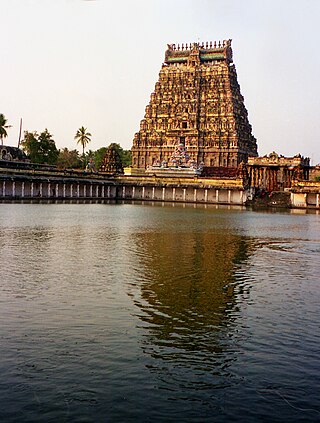
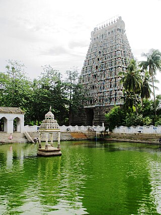
Chidambaram is a town and municipality in Cuddalore district in the Indian state of Tamil Nadu, on the banks of the Vellar River where it meets the Bay of Bengal. It is the headquarters of the Chidambaram taluk. The town is believed to be of significant antiquity and has been ruled, at different times, by the Pallavas until ninth century, Medieval Cholas, Later Cholas, Later Pandyas, Vijayanagara Empire, Thanjavur Nayakas, Marathas and the British. The town is known for the Thillai Nataraja Temple and Thillai Kali Temple, and the annual chariot festival held in the months of December–January and June to July. One of the Divya Desams Divya Sri Govindaraja Perumal Temple (Thiruchitrakoodam) is a part of Thillai Nataraja Temple complex. Thiruvetkalam Shiva Temple, Vadakiruppu, Thirunelvayil Shiva Temple, Sivapuri and Tirukkazhippalai Palvannanathar Temple are the other three ancient Shiva temples in the region.

<span class="mw-page-title-main">Dharmapuri</span> City in Tamil Nadu, India

Dharmapuri is a city in the north western part of Tamil Nadu, India. It serves as the administrative headquarters of Dharmapuri district which is the first district created in Tamil Nadu after the independence of India by splitting it from then Salem district on 2 October 1965. The city is located 50 km from Krishnagiri, 69 km from Salem, 60 km from Tirupattur, 90 km from Hosur, 117 km from Thiruvannamalai, 126 km from Bangalore and Erode, 181 km from Tiruppur, 200 km from Coimbatore and Tiruchirappalli, 300 km from Madurai and the state capital Chennai. It is located between latitudes N 11 47’ and 12 33’ and longitudes E 77 02’ and 78 40’. It is one of the major leading cultivators and producers of mangoes in the state along with Krishnagiri, and is often referred as Mango Capital of India.

<span class="mw-page-title-main">Vellore district</span> District of Tamil Nadu in India

Vellore district is one of the 38 districts in the Tamil Nadu state of India. It is one of the eleven districts that form the north region of Tamil Nadu. Vellore city is the headquarters of this district. As of 2011, the district had a population of 1,614,242 with a sex ratio of 1,007 females for every 1,000 males. In 2017 Vellore district ranked eleventh in list of districts in Tamil Nadu by Human Development Index.

<span class="mw-page-title-main">Gingee</span> Special Grade Town Panchayat in Tamil Nadu, India

Gingee, also known as Senji or Jinji and originally called Singapuri, is a panchayat town in Viluppuram district in the Indian state of Tamil Nadu. Gingee is located between three hills covering a perimeter of 3 km, and lies west of the Sankaraparani River.

<span class="mw-page-title-main">Thiruthuraipoondi</span> Town in Tamil Nadu, India

Thiruthuraipoondi is a municipality in Tiruvarur district in the Indian state of Tamil Nadu. Thiruthuraipoondi is an agricultural town located south of Thiruvarur district. The town is located at a distance of 28 km from the district headquarters Thiruvarur.

Valavanur is a panchayat town in Viluppuram district in the Indian state of Tamil Nadu. It is situated near to the Tamil Nadu–Puducherry border on NH 45A.

Vikravandi is a town in Viluppuram district in the Indian state of Tamil Nadu.

Aarani, officially spelled as Arni, and also known as Periya Aarani, is a major commercial, industrial and cultural hub and also a divisional headquarter in the Thiruvanamalai district of Tamil Nadu, India. The town is the second largest urban center next to the district headquarters, Thiruvannamalai, and is administered by a selection grade municipality. Aarani is home to silk weaving, spinning mills and agricultural industries. Famous Aarani silk and a paddy variety named Aarani Ponni, known for its rich aroma, originates from Aarani. The town is often nicknamed as The Silk City. Aarani also has a rich cultural heritage as it is a major center of Tamil Jainism.

<span class="mw-page-title-main">Viluppuram</span> Special Grade Municipality in Tamil Nadu, India

Viluppuram, Villupuram, or Vizhuppuram is a municipality and the administrative headquarters of Viluppuram district.

Brammadesam is an Indian Panchayat village located in Tindivanam taluk of Villupuram district in the state of Tamil Nadu. It is one of the 56 village panchayats coming under Marakkanam block of the Villupuram district. The village code for Brahmadesam is 10 and it falls under the Marakkanam Block.

Koonimedu is a panchayat village in Tamil Nadu, India. It is part of the Marakkanam block of the Viluppuram district and is located 16 kilometres from Pondicherry and 130 km (81 mi) from Chennai. It has a population of approximately 5000 people, of whom 50% are Muslims and the remaining 50% predominantly non Muslims.Koonimedu is also known as chinna Kuwait because of their occupational route. One after another, koonimedu people travelleing Kuwait to earn. Apart from Kuwait, some other countries where Koonimedu NRIs living is Singapore, Malaysia, UAE, Oman, Qatar, France and Saudi Arabia. Koonimedu village was one of the oldest villages in Villupuram. It is said that, Muslim population spread here during period King Arcod Nawab, for his soldiers passing way to Pondicherry old French colony. The latitude 12.11574 and longitude 79.907041 are the geocoordinate of the Koonimedu. Chennai is the state capital for Koonimedu village. It is located around 116.5 km (72.4 mi) away from Koonimedu.. The other nearest state capital from Koonimedu is Pondicherry and its distance is 21.3 km The other surrounding state capitals are Pondicherry 21.3 km, Bangalore 271.3 km, Thiruvananthapuram 506.5 km (314.7 mi)

Veedur is a village panchayat in the Viluppuram district of Tamil Nadu state, India. It is the largest village by area and population in the district. National Highway No. 45, from Chennai to Dindigul via Tiruchirapalli, goes through the hamlet.

<span class="mw-page-title-main">Viluppuram Junction railway station</span> Railway station in Tamil Nadu

Villupuram Junction is an NSG–3 category Indian railway station in Tiruchirappalli railway division of Southern Railway zone. It is a railway station in Viluppuram, Tamil Nadu. Being a prominent railway station, it serves as the distribution point of rail traffic from Chennai, the state capital of Tamil Nadu, towards the southern and central parts of the state. It is the third largest junction by number of branch lines in the state of Tamil Nadu after Salem junction,Tiruchchirapalli Junction.

The town of Viluppuram in the Indian state of Tamil Nadu is well connected by both rail and road to other major cities in the state including Chennai, Trichy, Madurai, Salem, Thanjavur, Coimbatore, Dindigul and Vellore. And also other state major cities such as Bengaluru, Tirupati, Pondicherry and Mangalore. Viluppuram serves as one of the important railway junction of Tamil Nadu and Southern Railway Zone. The nearest domestic airport is Pondicherry, which has a daily chartered flight to Bengaluru. The nearest international airports are Chennai and Tiruchirappalli.

Tiruvannamalai is predominantly connected by road to other major cities in the state including Chennai, Bengaluru, Vellore, Arani, Trichy, Tiruppur, Salem, Thanjavur, Coimbatore, Shimoga and Kanchipuram. And also other state major cities such as Hyderabad, Tirupati, Puducherry and Mangaluru. Tiruvannamalai serves as one of the important Road junction of Tamil Nadu and north roadways Zone. The nearest domestic airport is Vellore, which has a no daily chartered flights. The nearest international airports are Chennai and Tiruchirappalli.

Endiyur is a village panchayat located in Tindivanam, in the Villupuram district of Tamil-Nadu, India. The native language of the village is Tamil. The village is connected to nearby places through SH-134. The nearest railway station is Tindivanam which is 5 km from the village. Puducherry is 32.8 km from Endiyur. The village has a Draupadi Amman temple.

<span class="mw-page-title-main">Kandamangalam</span> Panchayat Union in Tamil Nadu, India

Kandamangalam (Tamil:கண்டமங்கலம்) is a town in Villupuram district, Vikravandi taluk of Tamil Nadu. The town is one of the 13 panchayat unions in Villupuram district. The city falls under Vanur Assembly constituency and Viluppuram Lok Sabha constituency.

<span class="mw-page-title-main">Periyababusamudram</span> Place in Tamil Nadu, India

Periyababusamudram or Periyababusamuthiram is a village located in Kandamangalam block in Villupuram district of Tamil Nadu. This village falls under Vanur Assembly constituency and Viluppuram Lok Sabha constituency. 

References

  1. "Census of India: Search Details".
  2. Villupuram District Govt Website. "Narasimma Swamy Koil - Ennairam" . Retrieved 5 July 2010.
  3. "Maps, Weather, and Airports for Tindivanam, India".
  4. 1 2 "Census Info 2011 Final population totals". Office of The Registrar General and Census Commissioner, Ministry of Home Affairs, Government of India. 2013. Retrieved 26 January 2014.
  5. "Census Info 2011 Final population totals - Tindivanam". Office of The Registrar General and Census Commissioner, Ministry of Home Affairs, Government of India. 2013. Retrieved 26 January 2014.
  6. "Population By Religious Community - Tamil Nadu" (XLS). Office of The Registrar General and Census Commissioner, Ministry of Home Affairs, Government of India. 2011. Retrieved 13 September 2015.
  7. "List of Parliamentary and Assembly Constituencies" (PDF). Tamil Nadu. Election Commission of India. Archived from the original (PDF) on 4 March 2009. Retrieved 8 October 2008.
  8. "Chairman - Tindivanam Municipal Council". Tindivanam Municipality, Municipal Web Portal, Govt of Tamil Nadu.
  9. "Vice Chairman - Tindivanam Municipal Council". Tindivanam Municipality, Municipal Web Portal, Govt of Tamil Nadu.
  10. "Commissioner - Tindivanam Municipal Council". Tindivanam Municipality, Municipal Web Portal, Govt of Tamil Nadu.
  11. "TNAU Portal".
  12. "Fossil Wood parks". Geological Survey of India. Archived from the original on 13 October 2013. Retrieved 4 June 2013.[ verification needed ]
  13. Kodinhi, Hussain. "Millions of years ago, there lived a tree". The Times of India. Archived from the original on 6 July 2009. Retrieved 4 June 2013.[ verification needed ]
  14. VCK candidate vows to put Vanur on tourism map, The Hindu newspaper, 12-May-2016 [ verification needed ]
  15. These trees speak, but not many hear, The Hindu ne village on the road between Tindivanam and Pondicherry.wspaper, 2-Nov-2014 [ verification needed ]
  16. "Lifeless air hovers over Fossil Wood Park". 16 February 2012. Archived from the original on 21 September 2013. Retrieved 4 June 2013.[ verification needed ]
  17. Prasanna, Srinivasan (17 January 2001). "Forest of Brown". The Hindu . Archived from the original on 21 September 2013. Retrieved 4 June 2013.[ verification needed ]
  18. Yamunan, Shruthisagar (25 September 2010). "A repository of spectacularly preserved fossilized trees". The Hindu. Archived from the original on 22 September 2013. Retrieved 4 June 2013.[ verification needed ]