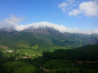
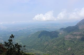
The Western Ghats or the Western Mountain range is a mountain range that covers an area of 160,000 km2 (62,000 sq mi) in a stretch of 1,600 km (990 mi) parallel to the western coast of the Indian peninsula, traversing the states of Gujarat, Maharashtra, Goa, Karnataka, Kerala and Tamil Nadu. It is a UNESCO World Heritage Site and is one of the 36 biodiversity hotspots in the world. It is sometimes called the Great Escarpment of India. It contains a very large proportion of the country's flora and fauna, many of which are endemic to this region. According to UNESCO, the Western Ghats are older than the Himalayas. They influence Indian monsoon weather patterns by intercepting the rain-laden monsoon winds that sweep in from the south-west during late summer. The range runs north to south along the western edge of the Deccan Plateau and separates the plateau from a narrow coastal plain called Konkan along the Arabian Sea. A total of 39 areas in the Western Ghats, including national parks, wildlife sanctuaries and reserve forests, were designated as world heritage sites in 2012 – twenty in Kerala, ten in Karnataka, six in Tamil Nadu and four in Maharashtra.
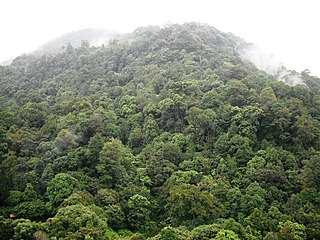
The South Western Ghats montane rain forests is an ecoregion in South India, covering the southern portion of the Western Ghats in Karnataka, Kerala and Tamil Nadu at elevations from 1,000 to 2,695 m. Annual rainfall in this ecoregion exceeds 2,800 mm (110 in).
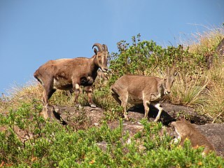
The Nilgiri tahr is an ungulate that is endemic to the Nilgiri Hills and the southern portion of the Western and Eastern Ghats in the states of Tamil Nadu and Kerala in southern India. It is the state animal of Tamil Nadu. Despite its local name, it is more closely related to the sheep of the genus Ovis than the ibex and wild goats of the genus Capra. It is the only species in the genus Nilgiritragus.
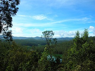
Sholas are the local name for patches of stunted tropical montane forest found in valleys amid rolling grassland in the higher montane regions of South India, largely in Kerala, Karnataka and Tamilnadu. These patches of shola forest are found mainly in the valleys and are usually separated from one another by undulating montane grassland. The shola and grassland together form the shola-grassland complex or mosaic. Not all such high-elevation grasslands have sholas in their valleys, especially if they are isolated from other such meadows, such as the meadows found in the Idamalayar Reserve Forest in Ernakulam district of Kerala. The word 'Shola' is probably derived from the Tamil language word cõlai (சோலை) meaning grove.

Anamudi is a mountain located in Ernakulam district and Idukki district of the Indian state of Kerala. It is the highest peak in the Western Ghats and in South India, at an elevation of 2,695 metres (8,842 ft) and a topographic prominence of 2,479 metres (8,133 ft). The name Anamudi literally translates to "elephant's head" a reference to the resemblance of the mountain to an elephant's head. Anamudi is the highest mountain in peninsular India as well as the largest mountain in Kerala.

The Palani Hills are a mountain range in the southern Indian states of Kerala and Tamil Nadu. The Palani Hills are an eastward extension of the Western Ghats ranges, which run parallel to the west coast of India. The Palani Hills adjoin the high Anamalai range (Kerala) on the west, and extend east into the plains of Tamil Nadu, covering an area of 2,068 square kilometres (798 sq mi). The highest part of the range is in the southwest, and reaches 1,800-2,500 metres elevation; the eastern extension of the range is made up of hills 1,000-1,500 m (3,281-4,921 ft) high.
The Nilgiri Biosphere Reserve is a biosphere reserve in the Nilgiri mountains of the Western Ghats in South India. It is the largest protected forest area in India, spreading across Tamil Nadu, Karnataka and Kerala. It includes the protected areas Mudumalai National Park, Mukurthi National Park, Sathyamangalam Wildlife Sanctuary in Tamil Nadu; Nagarhole National Park, Bandipur National Park, both in Karnataka; Silent Valley National Park, Aralam Wildlife Sanctuary, Wayanad Wildlife Sanctuary, and Karimpuzha Wildlife Sanctuary in Kerala.

The Anamala or Anaimalai, also known as the Elephant Mountains, are a range of mountains in the southern Western Ghats of central Kerala and span the border of western Tamil Nadu in Southern India. The name anamala is derived from the Malayalam word aana and the Tamil word aanai, meaning elephant, or from tribal languages. Mala or Malai means 'hill', and thus 'Elephant hill'.
The term Malabar rainforests refers to one or more distinct ecoregions recognized by biogeographers:
- the Malabar Coast moist forests formerly occupied the coastal zone to the 250 metre elevation
- the South Western Ghats moist deciduous forests grow at intermediate elevations
- the South Western Ghats montane rain forests cover the areas above 1000 metres elevation

Periyar National Park and Wildlife Sanctuary (PNP) is a protected area located in the districts of Idukki and Pathanamthitta in Kerala, India. It is notable as an elephant reserve and a tiger reserve. The protected area encompasses 925 km2 (357 sq mi), of which 305 km2 (118 sq mi) of the core zone was declared as the Periyar National Park in 1982. The park is a repository of rare, endemic, and endangered flora and fauna and forms the major watershed of two important rivers of Kerala: the Periyar and the Pamba.

Mukurthi National Park (MNP) is a 78.46 km2 (30.3 sq mi) protected area located in the western corner of the Nilgiris Plateau west of Ootacamund hill station in the northwest corner of Tamil Nadu state in the Western Ghats mountain range of South India. The park was created to protect its keystone species, the Nilgiri tahr.

Eravikulam National Park is a 97 km2 national park located along the Western Ghats in the Idukki and Ernakulam districts of Kerala in India. Situated between 10º05'N and 10º20' north, and 77º0' and 77º10' east, it is the first national park in Kerala.
The Nilgiri Mountains form part of the Western Ghats in northwestern Tamil Nadu, Southern Karnataka, and eastern Kerala in India. They are located at the trijunction of three states and connect the Western Ghats with the Eastern Ghats. At least 24 of the Nilgiri Mountains' peaks are above 2,000 metres (6,600 ft), the highest peak being Doddabetta, at 2,637 metres (8,652 ft).
The Palani Hills Wildlife Sanctuary and National Park is a proposed protected area in Dindigul District, Tamil Nadu India. The park will be an upgrade and expansion of the 736.87 km2(PRO) Palani (Kodaikanal) Wildlife Sanctuary which was to be established in 2008. The park includes about 36% of the 2,068 square kilometres (798 sq mi) in the Palani Hills. The park is located between latitude 10°7' - 10°28' N and longitude 77°16' - 77°46' E. Central location is 1.5 kilometres (0.93 mi) east northeast of Silver Cascade Waterfall and 4 kilometres (2.5 mi) E X NE of Kodaikanal Lake.

Chinnar Wildlife Sanctuary is located 18 km north of Marayoor on State Highway 17 in the Marayoor and Kanthalloor panchayats of Devikulam taluk in the Idukki district of Kerala state in South India. It is one of 18 wildlife sanctuaries among the protected areas of Kerala.

Anamudi Shola National Park is a protected area located along the Western Ghats of Idukki district in Kerala state, India. It is composed of Mannavan shola, Idivara shola and Pullardi shola, covering a total area of around 7.5 km². Draft notification of this new park was released on 21 November 2003.

Mukurthi Peak is one of the highest peaks in the Western Ghats, situated on the border of Udagamandalam taluk, Nilgiris, Tamil Nadu, Nilambur taluk, Malappuram, and Kerala in India. It reaches an altitude of 2,554 m (8,379ft), and is the fifth-highest peak in South India.
Karian Shola National Park is a protected area in the Western Ghats, India, nominated as a national park in 1989. The Western Ghats are a chain of mountains running down the west of India parallel with the coast some 30 to 50 km inland. They are not true mountains, but the edge of a fault that resulted about 150 million years ago as the subcontinent of India split from Gondwanaland. They are older than the Himalayan mountain range and are clothed in ancient forests. They influence the weather in India as they intercept the incoming monsoon storm systems. The greatest rainfall occurs between June and September during the southwest monsoon, with lesser amounts falling in the northeast monsoon between October and November. The Western Ghats are a UNESCO World Heritage Site and are considered to be one of the eight most important "hotspots" of biological diversity in the world.
Elivai Mala is a 2,088-metre-tall (6,850 ft) peak in the Western Ghats of South India. The mountain lies in Palakkad district of Kerala, close to the border with Tamil Nadu. With a topographic prominence of 1,540 metres it is one of the ultra prominent peaks of South Asia. It forms the highest point in the Western Ghats to the immediate north of the Palakkad Gap. It is the highest peak in between Anamalai Hills and Nilgiri Hills in Western Ghats.
Kumarikkal Mala is a peak situated in the Chinnar Wildlife Sanctuary in Kerala at an altitude of 2,522 m (8,274 ft) above sea level. It is the highest peak in the Chinnar Wildlife Sanctuary and one of the highest peaks in Anamalai Hills exceeding 2,000 m (6,600 ft).
