
The Kaveri is a major river flowing across Southern India. It is the third largest river in the region after Godavari and Krishna. The catchment area of the Kaveri basin is estimated to be 81,155 km2 (31,334 sq mi) and encompasses the states of Tamil Nadu, Karnataka, Kerala, and the union territory of Puducherry.

Palar is a river of southern India. It rises in the Nandi Hills in Chikkaballapura district of Karnataka state, and flows 93 kilometres (58 mi) in Karnataka, 33 kilometres (21 mi) in Andhra Pradesh and 222 kilometres (138 mi) in Tamil Nadu before reaching its confluence into the Bay of Bengal at Vayalur about 75 kilometres (47 mi) south of Chennai. It flows as an underground river for a long distance only to emerge near Bethamangala town, from where, gathering water and speed, it flows eastward down the Deccan Plateau. The Towns of Bethamangala, Santhipuram, Kuppam, Mottur, Ramanaickenpet, Vaniyambadi, Ambur, Melpatti, Gudiyatham, Pallikonda, Anpoondi, Melmonavoor, Vellore, Katpadi, Melvisharam, Arcot, Ranipet, Walajapet, Kanchipuram, Walajabad, Chengalpattu, Kalpakkam, and Lattur are located on the banks of the Palar River. Of the seven tributaries, the chief tributary is the Cheyyar River.

The Bhavani is an interstate Indian river which flows through Indian states of Kerala and Tamil Nadu, India. It originates from the Western Ghats and is one among the three rivers of Kerala which flows in eastward direction.

Kallanai is an ancient dam built by Karikala of Chola dynasty in 150 CE. It was built across the Kaveri river flowing from Tiruchirapalli District to Thanjavur district, Tamil Nadu, India. Even though it is nearer to Trichy,the dam is located in Thanjavur district, 15 km from Tiruchirapalli and 45 km from Thanjavur. It is the fourth oldest water-diversion or water-regulator structure in the world and the oldest in India that is still in use. Because of its spectacular architecture, it is one of the prime tourist spots in Tamil Nadu.
Courtallam is a panchayat town situated at a mean elevation of 160 m (520 ft) in the foothills of the Western Ghats in Tenkasi district of Tamil Nadu, India. The Coutrallam Falls on the Chittar River is a major tourist attraction.

Periyar, is the longest river and the river with the largest discharge potential in the Indian state of Kerala. It is one of the few perennial rivers in the region and provides drinking water for several major towns. The Periyar is of utmost significance to the economy of Kerala. It generates a significant proportion of Kerala's electrical power via the Idukki Dam and flows along a region of industrial and commercial activity. The river also provides water for irrigation and domestic use throughout its course besides supporting a rich fishery. Due to these reasons, the river has been named the "Lifeline of Kerala". Kochi city, in the vicinity of the river mouth, draws its water supply from Aluva, an upstream site sufficiently free of seawater intrusion. Twenty five percent of Kerala's industries are along the banks of the Periyar. These are mostly crowded within a stretch of 5 kilometres (3 mi) in the Eloor-Edayar region (Udhyogamandal), about 10 kilometres (6 mi) north of Kochi harbor.

The Mettur Dam is one of the largest dams in India and also the largest in Tamil Nadu, located across the river Kaveri where it enters the plains. Built in 1934, it took nine years to complete. Maximum height and width of the dam are 214 and 171 feet, respectively. The dam receives inflows from its own catchment area, Kabini Dam and Krishna Raja Sagara Dams located in Karnataka. There is a park at the base of the dam. It provides irrigation and drinking water facilities for more than 12 districts of Tamil Nadu and hence is revered as the life and livelihood-giving asset of Tamil Nadu.

The Thamirabarani or Tamraparni or Porunai is a perennial river that originates from the Agastyarkoodam peak of Pothigai hills of the Western Ghats, above Papanasam in the Ambasamudram taluk. It flows through Tirunelveli and Thoothukudi districts of the Tamil Nadu state of southern India into the Gulf of Mannar. It was called the Tamraparni River in the pre-classical period, a name it lent to the island of Sri Lanka. The old Tamil name of the river is Porunai. From the source to sea, the river is about 128 kilometres (80 mi) long and is the only perennial river in Tamil Nadu. This river flows towards north direction initially. However, it changes to east direction later.

Pechiparai Reservoir is the largest dam in Kanyakumari district. It is located in the foothills of the Western Ghats in the Kanyakumari district of Tamil Nadu at Pachiparai. It is located 43 kilometers (27 mi) from the district capital Nagercoil. This dam is built across the Kotai river. This dam was built during the period 1897-1906 by the European engineer Mr. Minchin by the then Maharaja of Travancore during the Thirunal period. This dam fulfills the agricultural and drinking water needs of Kanyakumari and Tirunelveli district. The height of this dam was originally 42 feet, then in 1964 it was decided to add 6 more feet and in 1969 the height of the dam was 48 feet. The Pachiparai Dam, which was 42 feet, was raised to 48 feet. An additional 3.75 TMC of water is added after the dam is raised. The 42 feet Pachipara dam was raised to 48 feet by Kamaraj.
Tirunelveli district is one of the 38 districts of Tamil Nadu state in India. It is the largest district in terms of area with Tirunelveli as its headquarters. The district was formed on 1 September 1790 by the British East India Company and comprised the present Tirunelveli and Thoothukudi, Tenkasi and parts of Virudhunagar and Ramanathapuram district. As of 2011, the undivided district had a population of 30,77,233.

Perunchani Dam is an irrigation dam at Perunchani, Kanyakumari District, in the state of Tamil Nadu, India. It is one of the dams of the Kodayar Irrigation System. As there was water deficiency in the Kodayar Irrigation System, Perunchani Dam was constructed in December 1952 to store flood water of the Paralayar River as an extension. It was built about 1 km (0.62 mi) upstream of the Puthen dam on the Paralayar River. The irrigation system became operational on 2 September 1953. It feeds the left bank irrigation canal system of the Puthen dam, which is the terminal structure of the system.
Kalingarayan Canal is a 56.2-mile (90.5 km) long irrigation canal in the Erode district, Tamil Nadu, India. It was constructed by Kongu chieftain Kalingarayan. The canal's source is the Kalingarayan Anicut near Bhavani. The canal irrigates approximately 15,743 acres (6,371 ha) of agricultural land. The project including construction of the dam and canal started in 1271 and was completed in 1283.
Thayar Thoppu is a village comes under Veerakeralampudur Panchayat, Veerakeralamputhur taluk, Tenkasi District Tamil Nadu, India. It locates between Alangulam and veerakeralampudur. Like any Indian rural village, this village too is steeped in tradition and rich in heritage, struggling to hold on to its past glories. Here the modern co-exist peacefully with the bullock-carts of yesterday years It's Panchayath union comes under Kilapavoor. It has one Government primary school. Due to its location near Courtallam, the climatic condition is just awful and drizzles during Courtallam season.
The Koraiyar River is a river in the Ambasamudram taluk of the Tirunelveli district of the Indian state of Tamil Nadu. It is a right-bank tributary of the Thamirabarani River, which flows through Tirunelveli and Thoothukudi districts. It is formed by the confluence of the minor Vadakkur Koraiyar and Therkku Koraiyar rivers, which are its headwater streams, on the eastern slopes of the Western Ghats. It flows for a total length of 13.2 kilometres (8.2 mi) before flowing into the Kannadian channel near the village of Vellankuli upstream of the Kannadian anicut. The channel bypasses the anicut before joining the Thamirabarani downstream and to the east of the dam. Along its course it is joined by three tributaries, the Vandal Odai, Elumichaiyar, and Koppuraiyar rivers. The Koraiyar's drainage basin covers an area of 75.75 square kilometres (29.25 sq mi) and has a recorded maximum flood discharge of 12000 cusecs.
Aluthakanniar is a river flowing in the Tirunelveli district of the Indian state of Tamil Nadu. It is one of the tributaries of Chittar River, which joins Tamiraparani near Tirunelveli. It arises in the eastern slopes of the Western Ghats, and forms the Old Kutralam falls as it descends down the mountain. It flows 10 kilometres (6 mi) towards northeast before joining its main river Chittar near Kadapagothi village.

Gadananathi (கடனாநதி)also can be called as Gadananadhi or Gatananadhi or Kadananathi or Kadananadhi is a river flowing in the Tirunelveli district of the Indian state of Tamil Nadu.
Ramanathi (ராமாநதி) is a river flowing in the Tenkasi of the Indian state of Tamil Nadu.Gadananathi originates from Agasthyamalai Biosphere Reserve.This river enters Gadananathi River in Kizha Ambur. The Ramanadhi has 7 anicuts, a reservoir of 4,300,000 cubic metres (3,500 acre⋅ft), and irrigates 20.23 square kilometres (7.81 sq mi) of wetlands. This river flows on many villages like Alwarkurichi, Ravanasamudram, Pottalpudur, Pillaukulam.The Gadananathi is fed by Thekkaru and Ramanathi Rivers.This was proposed and opened by Karunanithi.

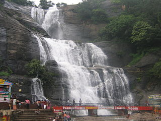
Coutrallam Falls is located in Tenkasi district in the South Indian state of Tamil Nadu bordering Kollam district, Kerala. The falls is located on the Western Ghats on the river Chittar and is considered a "medical spa" on account of the medical smell in the waters. It is located 5 km (3.1 mi) from the nearest city Tenkasi. There are a total of nine falls of which Peraruvi, Aintharuvi and Puli Aruvi being the most prominent.
Perumpallam Canal is an irrigation canal in the city of Erode in Tamil Nadu. The canal traverses from west to east across the city and flows into River Kaveri. It runs for a length of about 20 kilometres (12 mi).

The Manimuthar Dam is located in Manimutharu 50.8 kilometres (31.6 mi) away from Tirunelveli in Tamil Nadu, India. It is the biggest reservoir of the Tirunelveli district. This dam was built in 1958 near Singampatti and Kallidaikurichi, by the then Tamil Nadu Chief Minister K. Kamaraj, and K T Kosalram MP to prevent mixing of rainwater with the Bay of Bengal during the rainy season. It can hold water up to 118 feet. The dam is 5,511 million cubic feet. The total length of the dam is 3 km It irrigated around 65,000 acres of areas in the northern part of the Nanguneri Taluk and Thisayanvilai and southern Veeravanallur, Karispalpatti, which are not irrigated by Pachaiyaaru in Tirunelveli district. The downstream joins River Thamirabarani in Kallidaikurichi after 6 km of its journey.
