Tadiandamol

Last updated

Tadiandamol
Tadiandamol Trek 25Aug Pic 3 View From Top.jpg
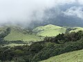
Sholas grassland viewed from Tadiandamol peak
Highest point
Elevation 1,748 m (5,735 ft)
Coordinates 12°13′3.2308″N75°36′31.7340″E / 12.217564111°N 75.608815000°E / 12.217564111; 75.608815000
Geography
Karnataka relief map.svg
Red triangle with thick white border.svg
Tadiandamol
Location of Tadiandamol, Karnataka
India relief location map.jpg
Red triangle with thick white border.svg
Tadiandamol
Tadiandamol (India)
Location Madikeri Taluk , Kodagu District, Karnataka, India
Parent range Western Ghats
Climbing
Easiest route Hike

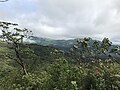
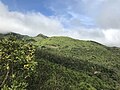
Tadiandamol or Thadiyandamol is the highest mountain of Madikeri taluk Kodagu district, Karnataka, India. It is the third highest peak in Karnataka, after Mullayyanagiri & Kudremukha. [1] It is located Western Ghats range, and reaches an elevation of 1,748 m. The mountain has patches of shola forests in the valleys.

Contents

The Nalaknad (also known as Nalnad - meaning 4 villages) palace at the foothills is an important historical landmark. This was one of the landmarks mapped during the Great Trigonometric Survey.

It is a place of interest for trekkers and naturalists. The climb to the top and back can be completed as a day hike(within 5hrs); camping is banned since December 2016.

Etymology

The name Tadiandamol literally means largest base (thadi = broad, large, huge; anda = belonging to (possessive) in Kodava; mol = hill, base, peak). It loosely means Tallest Mount, [2] and the name also could translate as Broad Hill. [3]

See also

Related Research Articles

<span class="mw-page-title-main">Kodagu district</span> District of Karnataka in India

Kodagu district is an administrative district in the Karnataka state of India. Before 1956, it was an administratively separate Coorg State, at which point it was merged into an enlarged Mysore State.

<span class="mw-page-title-main">Manaslu</span> Eight-thousander and 8th-highest mountain on Earth, located in Nepal

Manaslu is the eighth-highest mountain in the world at 8,163 metres (26,781 ft) above sea level. It is in the Mansiri Himal, part of the Nepalese Himalayas, in the west-central part of Nepal. The name Manaslu means "mountain of the spirit" and is derived from the Sanskrit word manasa, meaning "intellect" or "soul". Manaslu was first climbed on May 9, 1956, by Toshio Imanishi and Gyalzen Norbu, members of a Japanese expedition. It is said that, given the many unsuccessful attempts by the British to climb Everest before Nepali Tenzing Norgay and New Zealander Edmund Hillary, "just as the British consider Everest their mountain, Manaslu has always been a Japanese mountain".

<span class="mw-page-title-main">Kalsubai</span> Mountain in India

Kalsubai is a mountain in the Western Ghats, located in the Indian state of Maharashtra. Kalsubai is the highest peak in Maharashtra and is located in Ahmednagar district in Akole Taluka. Its summit, situated at an elevation of 1,646 metres (5,400 ft), is the highest point in Maharashtra. Hence, known as the Everest of Maharashtra.

<span class="mw-page-title-main">Ponmudi</span> Hill station in Kerala, India

Ponmudi also known as Ooty of South Kerala, Kashmir of Kerala is a hill station in the Peringamala gramapanchayath of Trivandrum District of Kerala in India. It is located 22km west of Vithura town, 53 km north-east of Trivandrum City, 78 km south-east of Varkala town and 69 km north-east of Kovalam Beach at an altitude of 1,100 m (3,600 ft). Ponmudi (Varayadumotta) peak is a part of the Western Ghats mountain range that runs parallel to the Arabian Sea. Ponmudi is a popular honeymoon destination in South India. The normal temperature of Ponmudi is between 18 and 25 °C.

<span class="mw-page-title-main">Kodachadri</span> Mountain peak in South India

Kodachadri is a mountain peak with dense forests in the Western Ghats in South India, 78 km from Shimoga. Kodachadri is the highest peak in Shivamogga district. It is declared as natural heritage site by the Karnataka Government. and it is 13th highest peak of Karnataka.

<span class="mw-page-title-main">Kemmangundi</span> Village in Karnataka, India

Kemmannugundi is a hill station in Tarikere taluk of Chikkamagaluru district in the state of Karnataka, India. It is at the elevation of 1434m above sea level, with its peak at 1863m. This was the summer retreat of Krishnaraja Wodeyar IV, and as a mark of respect to the king, it is also known as Sri Krishnarajendra Hill Station. The station is ringed by the Baba Budan Giri Range, with cascades, mountain streams, and lush vegetation. Kemmangundi has ornamental gardens and mountains and valleys views.

<span class="mw-page-title-main">Kudremukha</span> Mountain in Karnataka, India

Kudremukha is the name of a mountain range and an individual mountain peak located in Chikmagaluru district, in Karnataka, India. It is also the name of a small hill station and iron ore-mining town situated near the mountain, about 20 kilometres from Kalasa in Kalasa Taluk. The name Kuduremukha literally means "horse-faced" in Kannada and refers to a particular picturesque view of a side of the mountain that resembles a horse's face. It was also referred to as 'Samseparvata', historically since it was approached from Samse village. Kuduremukha is Karnataka's 2nd highest peak after Mullayanagiri and 26th highest peak in western ghats. The nearest International Airport is at Mangalore which is at a distance of 99 kilometres.

<span class="mw-page-title-main">Somwarpet</span> Town in Karnataka, India

Somwarpet is a panchayat town in Kodagu district in the Indian state of Karnataka. It is the main town of the Somwarpet taluk, in the north-east of the district. 2nd highest Administrative town in Karnataka in terms of elevation. The main crops grown in the area are coffee and spice crops such as cardamom, peppers, oranges, ginger and vegetables.

<span class="mw-page-title-main">Pushpagiri (mountain)</span>

Pushpagiri, at 5,626 feet (1,715 m) ft, is the highest peak in Pushpagiri Wildlife Sanctuary, Madikeri taluk district in the Western Ghats of Karnataka. It is located in the Somwarpet Taluk, 20 kilometres (12 mi) from Somwarpet in the northern part of Kodagu district on the border between Dakshina Kannada and Kodagu district and hassan districts. It is 4th highest peak of Karnataka.

<span class="mw-page-title-main">Pushpagiri Wildlife Sanctuary</span> Wildlife sanctuary in India

Pushpagiri Wildlife Sanctuary is one of the 21 Wildlife Sanctuaries in Karnataka, India.

<span class="mw-page-title-main">Tourism in Karnataka</span> Overview of tourism in Karnataka, India

Karnataka, the sixth largest state in India, has been ranked as the third most popular state in the country for tourism in 2014. It is home to 507 of the 3600 centrally protected monuments in India, second only to Uttar Pradesh. The State Directorate of Archaeology and Museums protects an additional 752 monuments and another 25,000 monuments are yet to receive protection.

<span class="mw-page-title-main">Bhagamandala</span> Village in Karnataka, India

Bhagamandala is a pilgrimage place in Kodagu district of the Indian state of Karnataka.

<span class="mw-page-title-main">Dras</span> Town in Ladakh, India

Dras, also known locally in Shina as Himababs, Hembabs, or Humas, is a town and hill station, near Kargil in the Kargil district of the union territory of Ladakh in India. It is on the NH 1 between Zoji La pass and Kargil. A tourist hub for its high-altitude trekking routes and tourist sites, it is often called "The Gateway to Ladakh". The government's official spelling of the town's name is "Drass".

<span class="mw-page-title-main">Kutta</span> Place in Karnataka, India

Kutta is a small village in Ponnampet taluk of Kodagu, in Karnataka state of India. As per census survey 2011, location code number of Kutta is 618078.

<span class="mw-page-title-main">Yelagiri</span> Hill Station in Tamil Nadu, India

Yelagiri is a hill station located in the newly formed Tirupattur district of Tamil Nadu, India, situated off the Vaniyambadi-Tirupattur road. Located at an altitude of 1,110.6 metres above Mean Sea Level and spread across 30 km2, the Yelagiri Hill is surrounded by orchards, rose-gardens, and green valleys. Yelagiri is a branch of Annamalai Hills.

<span class="mw-page-title-main">Madhyamaheshwar</span> Hindu temple in Gaundar village, Uttarakhand, India

Madhyamaheshwar or Madmaheshwar is a Hindu temple dedicated to Shiva, located in Gaundar, a village in the Garhwal Himalayas of Uttarakhand, India. Situated at an elevation of 3,497 m (11,473.1 ft), it is one of the Panch Kedar pilgrimage circuits, comprising five Shiva temples in the Garhwal region. The other temples in the circuit include: Kedarnath, Tungnath and Rudranath which are culturally visited before Madhyamaheshwar and, Kalpeshwar generally visited after Madhyamaheshwar. The middle (madhya) or belly part or navel (nabhi) of Shiva is worshipped here. The temple is believed to have been built by the Pandavas, the central figures of the Hindu epic Mahabharata.

Mullayyanagiri is the highest peak in Karnataka, India. Mullayyanagiri is located in the Chandra Dhrona Hill Ranges of the Western Ghats of Chikkamagaluru Taluk. With a height of 1,925 metres (6,316 ft), it is the highest peak in Karnataka and also the 23rd highest peak in Western Ghats. The summit of Mullayanagiri has a small temple and houses a police radio relay station. Seethalayyanagiri is a prominent peak which is adjacent to this place.

<span class="mw-page-title-main">Kala Pahar</span>

Kala Pahar, also known as Debbarma Haphong in Khasi, is the highest peak of northern Bangladesh. Located near Robir bazar of Kulaura Upazila in Moulvibazar District, it is only 3–4 hours trekking distance from Azgarabad Tea Estate. This peak is also accessible from Rajki tea estate near Fultola bazar of Juri Upazila. The hill range of Kala Pahar is locally known as Longla Range. 'Kala Pahar' is the local name of the highest peak. According to Bangladesh Geographic society this hill is also known as 'Hararganj pahar'. In Bengali language 'hill' word means 'Pahar'. Situated in the north-eastern part of the country 60% of the range is in Bangladesh and the rest is in the Northern Tripura state of India. In Tripura, part of this hill is known as Raghunandan pahar. The famous ancient religious archaeological site of India ‘Unakoti’ lies at the foot of this hill. Kala Pahar is about 1,100 feet high from the sea level. In November 2015, members of a local adventure group of Bangladesh BD Explorer explored this peak and measured the highest point as 1,098 feet with a Garmin handheld GPS. During autumn, if the sky is clear, one can observe the blue water of Hakaluki haor(Largest haor of Bangladesh) from the high point of Kala Pahar. There are some Khasi establishments adjacent to this hill, such as Nunchora punji, Panaichora punji, Putichora punji and Baigonchora punji.

<span class="mw-page-title-main">Somwarpet taluk</span> Taluk in Karnataka

Somawarpete taluk is one of the five taluks of Kodagu district. Its administrative headquarters is in the town of Somwarpet.

Shishila is a village located at the base of Western Ghats in Belthangady taluk of the Karnataka State, India. The main attraction of the village is a temple dedicated to Lord Shishileshwara.

References

  1. "Trekking These Highest Karnataka Peaks Will Make Your Friends Envy".
  2. "Codagu.org".
  3. Surendra Rao, B. (1998). "Google books".