Shivana River

Last updated

Shivana River
Shivana River (2).jpg
Shivana River
Native nameशिवना नदी (Marathi)
Location
Country India
State Maharashtra
Region Marathwada
District Shambhaji Nagar
City Kannad
Physical characteristics
SourceAjanta Range
  location Gautala Wildlife Sanctuary, Shambhali Nagar, Marathwada, Maharashtra, India
  coordinates 20°33′N75°19′E / 20.550°N 75.317°E / 20.550; 75.317
  elevation838 m (2,749 ft)
Mouth Godavari River
  location
NathSagar Reservoir, Shambhali Nagar, Marathwada, Maharashtra
  coordinates
19°10′N72°02′E / 19.167°N 72.033°E / 19.167; 72.033 Coordinates: 19°10′N72°02′E / 19.167°N 72.033°E / 19.167; 72.033
  elevation
351 m (1,152 ft)

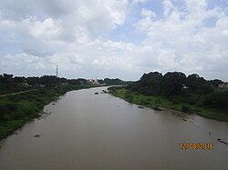
Shivana River is a minor but important tributary of Godavari lying entirely within Aurangabad district, [1] Maharashtra. It rises in the Kannad taluka, [2] from the south-western slope of the Ajanta Hills which also holds the origin to another major tributary Purna.

Contents

Origin

The river collects streams draining the Gautala Wildlife Sanctuary from the southern slopes of the Ajanta Hills.

Course

From the point of origin flows southeast for a short course till the town Kannad. Here the river is interrupted by presence of the Ambadi Dam. [3] The reservoir thus formed provides a water resource used for human consumption and is rich in fish diversity.[ citation needed ] From Kannad, the river flows in a south-eastern direction and is impounded by another dam known as the Shivana Takli Dam. [4] Upon reaching Jambarkheda, the river changes its course to flow south wards until Kate Pimpalgaon where it resumes the south-eastern course, ideal of most rivers of the Deccan Plateau. The river ends itself by merging seamlessly into the back waters of the NathSagar Reservoir formed by the Jayakwadi Dam on the river Godavari.It goes through Mandsaur district and touch the statue of Pashupatinath god in rainy season.

Dams

Related Research Articles

<span class="mw-page-title-main">Godavari River</span> River in India

The Godavari is India's second longest river after the Ganga river and drains into the third largest basin in India, covering about 10% of India's total geographical area. Its source is in Trimbakeshwar, Nashik, Maharashtra. It flows east for 1,465 kilometres (910 mi), draining the states of Maharashtra (48.6%), Telangana (18.8%), Andhra Pradesh (4.5%), Chhattisgarh (10.9%) and Odisha (5.7%). The river ultimately empties into the Bay of Bengal through an extensive network of tributaries. Measuring up to 312,812 km2 (120,777 sq mi), it forms one of the largest river basins in the Indian subcontinent, with only the Ganga and Indus rivers having a larger drainage basin. In terms of length, catchment area and discharge, the Godavari is the largest in peninsular India, and had been dubbed as the Dakshina Ganga.

<span class="mw-page-title-main">Jalna district</span> District of Maharashtra in India

Jalna district is an administrative district in the state of Maharashtra in western India. Jalna town is the district headquarters. The district is part of Aurangabad division.

<span class="mw-page-title-main">Wainganga River</span> River in Maharashtra, India

The Wainganga is a river in India originating in the Mahadeo Hills in Mundara in Gondwana region near the village Gopalganj in Seoni, Madhya Pradesh. It is a key tributary of the Godavari. The river flows south in a winding course through the states of Madhya Pradesh and Maharashtra, roughly 580 km (360 mi). After joining the Wardha River, the united stream, which is known as the Pranahita River, empties into the Godavari River at Kaleshwaram, Telangana.

<span class="mw-page-title-main">Indravati River</span> River in India

Indravati River is a tributary of the Godavari River, in central India.

<span class="mw-page-title-main">Aurangabad district, Maharashtra</span> District of Maharashtra in India

Aurangabad district is one of the 36 districts of the state of Maharashtra in western India. It borders the districts of Nashik to the west, Jalgaon to the north, Jalna to the east, and Ahmednagar to the south. The city of Aurangabad houses the district's administrative headquarters. The district has an area of 10,100 km2, of which 37.55% is urban and the rest is rural. Aurangabad District is a major tourism region in Marathwada.

Pusad is a city in the Yavatmal district located in Vidarbha region of Maharashtra state of India. It is named after the Pus river. Its ancient name was 'Pushpawanti'. Pusad is second largest city of yavatmal district. For last 20 years Pusad is being tried to be promoted to the stature of district but due to lack of administration of governing bodies it is only a dream of the people.

Kannad is a Taluka and a Municipal Council City in Aurangabad District in the Indian state of Maharashtra. Kannad has located 58 km from Aurangabad. It is located 24 km away from the Ellora Caves and Grishneshwar Temple. It is 45 Km from Daulatabad / Deogiri Fort.

Vaijapur is a city and a municipal council in Aurangabad district in the Indian state of Maharashtra. It is bordered by the Nashik districts to the west, Kannad tehsil to the north, Gangapur tehsil to the east, and Ahmednagar districts to the south. Vaijapur is the headquarters of Vaijapur tehsil and also known as the Gateway of Marathwada.

<span class="mw-page-title-main">Manjira River</span> Tributary of river Godavari

The Manjara, also spelled Manjara or Manjeera, is a tributary of the river Godavari. It passes through the states of Maharashtra, Karnataka and Telangana. It originates in the Balaghat range of hills near Ahmednagar district at an altitude of 823 metres (2,700 ft) and empties into the Godavari River. It has a total catchment area of 30,844 square kilometres (3,084,400 ha).

<span class="mw-page-title-main">Freshwater ecology of Maharashtra</span>

The state of Maharashtra in India has several major river systems including those of the Narmada, Tapti, Godavari and Krishna rivers. The ecology of these rivers and associated wetlands is covered in this article.

<span class="mw-page-title-main">Painganga River</span>

The Painganga River is the chief river of the Buldhana district, Hingoli district, Nanded district, Yavatmal district, Chandrapur district and Washim district in the Maharashtra state in India. It flows along the southeast boundaries of the district in a winding, meandering course. It is deeply entrenched and difficult to navigate. It rises in the Ajantha range and is a major tributary of the Wardha River, the other major river in the district. It is also divided Marathwada and Vidarbha near Umarkhed.

<span class="mw-page-title-main">Jayakwadi Dam</span> Dam in Maharashtra, India

Jayakwadi dam is an earthen dam located on Godavari river at the site of Jayakwadi village in Paithan taluka of Aurangabad district in Maharashtra, India. It is a multipurpose project. The water is mainly used to irrigate agricultural land in the drought-prone Marathwada region of the state. It also provides water for drinking and industrial usage to nearby towns and villages and to the municipalities and industrial areas of Aurangabad and Jalna districts. The surrounding area of the dam has a garden and a bird sanctuary.

Ambadi Dam, is an earthfill dam on Sivana river near Village Andhaner, Kannad, Aurangabad district in state of Maharashtra in India.

<span class="mw-page-title-main">Upper Wardha Dam</span> Dam in Maharashtra, India

The Upper Wardha Dam is an earthfill straight gravity dam across the Wardha River, a tributary of the Godavari River, near Simbhora village in Morshi taluk in Amravati district in the Indian state of Maharashtra. The dam provides multipurpose benefits of irrigation, drinking water supply, flood control and hydropower generation.

Shivana Takli Dam, is an earthfill dam on Shivna river near Kannad, Aurangabad district in the state of Maharashtra in India.

<span class="mw-page-title-main">Purna River (tributary of Godavari)</span> River in Maharashtra, India

The Purna River is a major left-bank tributary of Godavari River originating in the Ajanta Range of hills in Aurangabad District, Maharashtra.The river lies in the rain shadow region of Maharashtra, on the Deccan Plateau, flowing through the districts of Aurangabad, Buldana, Jalna, Hingoli and Parbhani with a large catchment area measuring about 15,579 km2. This enormous catchment area is often tagged as a sub-basin of Godavari River and along with its tributaries forms a dendritic drainage pattern. It is a prime river in the Marathwada region of Maharashtra running for about 373 km before it converges with Godavari River south of Purna city in the Parbhani district.

<span class="mw-page-title-main">Pravara River</span> River in Maharashtra, India

Pravara is the smallest of the major tributaries of Godavari river located in Maharashtra, India. Among the 7 major tributaries, it is the only tributary which originates in the Western Ghats akin to Godavari. Also, it is the only major tributary of Godavari to have both its source and confluence located within the same district - Ahmednagar.

<span class="mw-page-title-main">Sindphana River</span> River in Maharashtra, India

Sindphana is a minor tributary of Godavari river that originates around the Chincholi hill in Patoda Taluka, Beed District, Maharashtra, in India. Crossing west to east its drainage basin covers nearly 80% of Beed District, making it the most important river within the district. The Majalgaon Dam, constructed across the river, irrigates 93885 hectares of land in Beed, Parbhani & Nanded districts.

Darna is a minor left-bank tributary of Godavari in the Nashik District, Maharashtra. Rising north of the Kalsubai range, it drains Igatpuri, Nashik and Niphad Talukas of Nashik District. The conjunction with Godavari is situated at Darnasangvi.

Kadva river is a minor but important tributary of Godavari in Nashik district, Maharashtra. It originates and flows through the Dindori Taluka of Nashik District.

References

  1. "Aurangabad". National Informatics Centre. Archived from the original on 4 January 2014. Retrieved 23 June 2022.
  2. "Village Map, Taluka Kannad" (PDF). Maharashtra Remote Sensing Applications Centre. Retrieved 13 October 2015.
  3. "Ambadi Dam D01388". WRIS-Water Resources Information of India. Retrieved 13 October 2015.
  4. "Shivana Takli Dam D03058". WRIS-Water Resources Information of India. Retrieved 13 October 2015.