Mahabubabad district

Last updated

Mahabubabad district
Ephiphany Cathedral Dornakal.jpg
Epiphany Cathedral, Dornakal
Mahabubabad in Telangana (India).svg
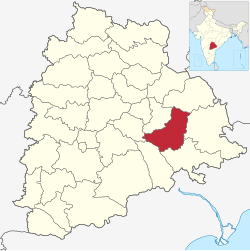
Location in Telangana
Mahabubabad district
Country India
State Telangana
Headquarters Mahabubabad
Mandalas 16
Government
   District collector Sri V.P.Goutham
   Parliament constituenciesMahabubabad
   Assembly constituenciesMahabubabad, Dornakal
Area
  Total2,876.70 km2 (1,110.70 sq mi)
Population
 (2011)
  Total774,549
  Density270/km2 (700/sq mi)
Time zone UTC+05:30 (IST)
Vehicle registration TS–26 [1]
Website mahabubabad.telangana.gov.in

Mahabubabad district is a district in the Indian state of Telangana. [2] The district was carved out from the erstwhile Warangal district following the re-organisation of districts in the state in October 2016. [3] The district shares boundaries with Suryapet, Khammam, Bhadradri, Warangal, Mulugu and Jangaon districts.

Contents

Geography

Pandavula Guttalu Pandavula Gutta 2.jpg
Pandavula Guttalu

The district is spread over an area of 2,876.70 square kilometres (1,110.70 sq mi). [4] The region is mostly plain with occasional hillocks. Most of the land is used for agriculture. The mandals Bayyaram and Garla have rich iron ore and coal deposits. It also has Bheemunipadam waterfall and Edubavula waterfall. There are several popular hillocks such as Pandavula Guttalu in Bayyaram Mandal (Pandavula Guhalu, Thirumalagiri is different one, located in Jayshankar Bhupalpally district, east of Warangal).

The district is also famous for Kuravi Veerabhadra Swamy temple

Demographics

Religion in Mahabubabad district (2011) [5]
Hinduism
95.89%
Islam
3.28%
Christianity
0.51%
Other or not stated
0.32%

As of 2011 Census of India, the district has a population of 774,549. Mahabubabad has a sex ratio of 996 females per 1000 males and a literacy rate of 57.13%. 81,082 (10.47%) were under 6 years of age. 76,376 (9.86%) lived in urban areas. Scheduled Castes and Scheduled Tribes made up 104,508 (13.49%) and 292,778 (37.80%) of the population respectively. [6]

Languages of Mahabubabad district (2011) [7]

   Telugu (66.42%)
   Lambadi (30.25%)
   Urdu (2.59%)
  Others (0.74%)

At the time of the 2011 census, 66.42% of the population spoke Telugu, 30.25% Lambadi and 2.59% Urdu as their first language. [7]

Administrative divisions

The district has two revenue divisions, Mahabubabad and Thorrur and is sub-divided into 16 mandals.

Mandals

Mahbubabad District Map Mahabubabad district map.png
Mahbubabad District Map

The district has sixteen mandals .

The following are the list of mandals.

See also

Pictures

Related Research Articles

<span class="mw-page-title-main">Khammam district</span> District of Telangana in India


Khammam district is a district in the eastern region of the Indian state of Telangana. The city of Khammam is the district headquarters. The district shares boundaries with Suryapet, Mahabubabad, Bhadradri districts and with Eluru and NTR districts.

<span class="mw-page-title-main">Medak district</span> District of Telangana in India

Medak district is in the Indian state of Telangana. Medak is the district headquarters. The district shares boundaries with Sangareddy, Kamareddy, Siddipet and Medchal districts.

<span class="mw-page-title-main">Nizamabad district</span> District of Telangana in India

Nizamabad district is a district located in the north-western region of the Indian state of Telangana. The city of Nizamabad is the district headquarters. The district share boundaries with Jagtial, Sircilla, Nirmal, Kamareddy districts and with Nanded district of the state boundary of Maharashtra.

<span class="mw-page-title-main">Ranga Reddy district</span> District of Telangana in India

Ranga Reddy district is a district in the Indian state of Telangana. The district headquarters is located at Lakdikapool, Hyderabad. The district was named after the former deputy chief minister of the United Andhra Pradesh, K. V. Ranga Reddy. The district shares boundaries with Nalgonda, Yadadri Bhuvanagiri, Hyderabad, Medchal–Malkajgiri, Nagarkurnool, Mahabubnagar, Sangareddy and Vikarabad districts.

<span class="mw-page-title-main">Hanamkonda district</span> District of Telangana in India

Hanumakonda district, is a district located in the northern region of the Indian state of Telangana. The district headquarters are located at Hanumakonda. The district borders the districts of Jangaon, Karimnagar, Warangal, Bhupalpally and Siddipet.

<span class="mw-page-title-main">Mahabubabad</span> City in Telangana, India

Mahabubabad is a town and the district headquarters of Mahabubabad district in the Indian state of Telangana. It is on the west bank of the Munneru, which is one of the tributaries of the River Krishna. Mahabubabad is known for the Bayyaram Mines.

<span class="mw-page-title-main">Mulugu district</span> District of Telangana in India

Mulugu district is a district in the Indian state of Telangana. Its headquarters is the town of Mulugu. Mulugu district is the least populated district with 2,94,671 in the state. Mulugu district has the fewest mandals in the state with nine mandals. It currently borders Warangal, Mahabubabad, Jayashankar Bhupalpally and Bhadradri districts and with the state of Chhattisgarh.

<span class="mw-page-title-main">Narsampet</span> Mandal in Telangana, India

Narsampet is a village in Warangal district of the Indian state of Telangana. Narsampet is a Mandal in Warangal Rural District of Telangana State, India. Headquarters of Narsampet Revenue Division is in Narsampet Village. As part of Telangana Districts re-organisation, Narsampet Mandal re-organised from Warangal District to Warangal Rural district. The town is 36 km east of District Headquarter Warangal.

Charminar Express

Bayyaram Mines are iron ore mine located in Bayyaram in Mahabubabad district, Telangana, India. The mines also include Gudur Mandal in Warangal district.

<span class="mw-page-title-main">Mancherial district</span> District in Telangana, India

Mancherial district is a district located in the northern region of the Indian state of Telangana. The district comprises 18 mandals and two revenue divisions – Mancherial and Bellampalli. The district headquarters is located at Mancherial town. It is surrounded by Komaram Bheem, Nirmal, Jagtial, Peddapalli and Bhupalpally districts of Telangana and with Maharashtra state.

<span class="mw-page-title-main">Sangareddy district</span> District of Telangana in India

Sangareddy district, is a district in the Indian state of Telangana. This district contains a part of the Hyderabad Metropolitan Region. The district shares boundaries with Medak, Medchal, Vikarabad, Kamareddy and Rangareddy districts and with the state boundary of Karnataka.

<span class="mw-page-title-main">Warangal district</span> District of Telangana in India

Warangal district, formerly Warangal Rural district, is a district in the Indian state of Telangana. The district shares boundaries with Mahabubabad, Jangaon, Hanamkonda, Mulugu and Bhupalpally districts.

<span class="mw-page-title-main">Bhadradri Kothagudem district</span> District in Telangana, India

Bhadradri Kothagudem district is a district in the eastern region of the Indian state of Telangana. The town of Kothagudem is the district headquarters. In terms of area, Bhadradri Kothagudem is the second largest district with an area of 7015.69 km2 in the state. The district shares boundaries with Khammam, Mahabubabad, Mulugu, Eluru and East godavari and with state boundaries of Chhattisgarh The district comprises 24 mandals and 2 revenue divisions, Kothagudem and Bhadrachalam. The district headquarters is located at Kothagudem town.

<span class="mw-page-title-main">Suryapet district</span> District of Telangana in India

Suryapet district is a district in the Indian state of Telangana. The city of Suryapet is the district headquarters. The district has three revenue divisions Suryapet, Kodad and Huzurnagar. It is sub-divided into 23 mandals. The district shares boundaries with Nalgonda, Khammam, Yadadri, Jangaon and Mahabubabad districts and with Andhra Pradesh state.

<span class="mw-page-title-main">Medchal-Malkajgiri district</span> District of Telangana in India

Medchal−Malkajgiri district is a district in the Indian state of Telangana. Shamirpet is the headquarter of the district. It is the second most populous district with a population of 25 lakh and also 91.40% urbanized district in the state of Telangana, standing next only to Hyderabad district which has a population of 40 lakhs. The district shares boundaries with Hyderabad, Medak, Sangareddy, Y. Bhuvanagiri, Siddipet and Rangareddy districts.The most part of the district consist of Hyderabad City (GHMC)

<span class="mw-page-title-main">Wanaparthy district</span> District of Telangana in India

Wanaparthy district is a district in the Indian state of Telangana. Its headquarters is Wanaparthy. The district shares boundaries with Gadwal, Mahabubnagar, Narayanpet, Nagarkurnool districts and with the state boundary of Andhra pradesh.

<span class="mw-page-title-main">Jayashankar Bhupalpally district</span> District of Telangana in India

Jayashankar Bhupalpally district is a district in the Indian state of Telangana. The district headquarters are located at Bhupalpally. It was a part of the erstwhile Warangal district and Karimnagar district prior to the re-organisation of districts in the state. The district share boundaries with Karimnagar, Mancherial, Peddapalli, Hanamkonda, Warangal, and Mulugu districts and with the state boundary of Maharashtra and Chhattisgarh.

<span class="mw-page-title-main">Jagtial district</span> District of Telangana in India

Jagtial district is a district located in the northern region of the Indian state of Telangana. Its headquarters is Jagtial. The district shares boundaries with Nirmal, Mancherial, Karimnagar, Peddapalli, Sircilla and Nizamabad districts.

<span class="mw-page-title-main">Jangaon district</span> District of Telangana in India

Jangaon district is a district in the Indian state of Telangana. It was a part of the erstwhile Warangal district prior to the re-organisation of districts in the state. The district shares boundaries with Suryapet, Yadadri, Warangal, Hanamkonda, Siddipet and Mahabubabad districts.

References

  1. "Telangana New Districts Names 2016 Pdf TS 31 Districts List". Timesalert.com. 11 October 2016. Retrieved 11 October 2016.
  2. "Mahabubabad district" (PDF). Chief Commissioner of Land Administration. Archived from the original (PDF) on 9 September 2016. Retrieved 22 August 2016.
  3. "Telangana: Telangana gets 21 new districts". The Times of India. 12 October 2016.
  4. "New districts". Andhra Jyothy.com. March 2017. Retrieved 8 March 2017.
  5. "Population by Religion - Andhra Pradesh". Census of India . Registrar General and Census Commissioner of India. 2011.
  6. "Know your district Plan your district - Mahabubabad" (PDF). trac.telangana.gov.in. Telangana State Remote Sensing Applications Centre.
  7. 1 2 "Table C-16 Population by Mother Tongue: Andhra Pradesh". Census of India . Registrar General and Census Commissioner of India.

17°36′N80°00′E / 17.6°N 80.0°E / 17.6; 80.0