Yadadri Bhuvanagiri district | |
|---|---|
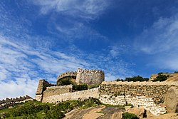 View of Bhongir Fort | |
 Location in Telangana | |
 Yadadri Bhuvanagiri district | |
| Coordinates(Bhongiri): 17°30'36"N, 78°53'24"E | |
| Country | |
| State | Telangana |
| Headquarters | Bhongir |
| Mandalas | 16 |
| Government | |
| • District collector | T, Vinay Krishna Reddy, IAS |
| • Add.District Collector | Sri D Srinivas Reddy |
| • Additional Collector Local Bodies | Sri Deepak Tiwari IAS |
| • Deputy Commissioner Of Police | Sri Narayana Reddy |
| • Administrative Officer | Sri M.Nageshwara Chary |
| Area | |
• Total | 3,091.48 km2 (1,193.63 sq mi) |
| Population (2011) | |
• Total | 770,833 |
| • Density | 249.341/km2 (645.790/sq mi) |
| Time zone | UTC+05:30 (IST) |
| Vehicle registration | TG–30 [1] |
| Nominal GDP (2022-23) | ₹24,611 crore (US$2.9 billion) [2] |
| Per capita Income ( 2022-23 ) | ₹267,605 (US$3,200) |
| Website | yadadri |
Yadadri Bhuvanagiri district [3] is a district in the Indian state of Telangana. [4] The administrative headquarters is located at Bhuvanagiri which is also known as Bhongiri. [5] [6] [7] The district shares boundaries with Suryapet, Nalgonda, Jangaon, Siddipet, Medchal-Malkajgiri and Rangareddy districts.