The Satpura Range is a range of hills in central India. The range rises in eastern Gujarat running east through the border of Maharashtra and Madhya Pradesh and ends in Chhattisgarh. The range parallels the Vindhya Range to the north, and these two east–west ranges divide Indian Subcontinent into the Indo-Gangetic plain of northern India and the Deccan Plateau of the south. The Narmada River originates from north-eastern end of Satpura in Amarkantak, and runs in the depression between the Satpura and Vindhya ranges, draining the northern slope of the Satpura range, running west towards the Arabian Sea. The Tapti River originates in the eastern-central part of Satpura, crossing the range in the center and running west at the range's southern slopes before meeting the Arabian Sea at Surat, draining the central and southern slopes of the range. Multai, the place of Tapi river origin is located about 465 kilometer far, south-westerly to Amarkantak, separated across by the hill range. The Godavari River and its tributaries drain the Deccan plateau, which lies south of the range, and the Mahanadi River drains the easternmost portion of the range. The Godavari and Mahanadi rivers flow into the Bay of Bengal. At its eastern end, the Satpura range meets the hills of the Chotanagpur Plateau. The Satpura Range is a horst mountain and is flanked by Narmada Graben in the north and much smaller but parallel Tapi Graben in the south.

Buldhana district is located in the Amravati division of Maharashtra, India. It is situated at the western border of Vidarbha region and is 500 km away from the state capital, Mumbai. The district has towns and cities like Shegaon, Malkapur, Khamgaon, Lonar and Chikhli. It is surrounded by Madhya Pradesh in the north, Akola, Washim, and Amravati districts on the east, Jalna district on the south, and Jalgaon and Aurangabad districts on the west. Khamgaon is the largest city in the district.

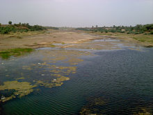
The Tapti River is a river in central India located to the south of the Narmada river that flows westwards before draining into the Arabian Sea. The river has a length of around 724 km (450 mi) and flows through the states of Maharashtra, Gujarat and Madhya Pradesh. It flows through Surat, and is crossed by the Magdalla, ONGC Bridge.

Amravati district is a district of Maharashtra state in central India. It is the administrative headquarter of Amravati division, which is one of the two divisions in Vidarbha, out of total 6 regions in state of Maharashtra.

The Wardha River, also known as the Varada River, is a major river in Vidarbha, Maharashtra, which originates in the Satpura Range and flows into the Wain ganga river to form the Pranhita river which finally joins the Godavari river.
The Vaan River is a river of central India. It is tributary of Purna River, which is major tributary of Tapti River. It is also spelled as Wan or Van. It is also known as Waanganga.
Jalgaon district is a district in Maharashtra, India. Its headquarters is the Jalgaon city.
Nashik Division is one of the six divisions of India's Maharashtra state and four of its five districts form Uttar Maharashtra. The three northernmost districts of Uttar Maharashtra form most of the historic Khandesh region which covers the northern part of the division in the valley of the Tapti River. Nashik Division is bound by Konkan Division and the state of Gujarat to the west, Madhya Pradesh state to the north, Amravati Division and Marathwada to the east, and Desh to the south.
Muktainagar is a town in Jalgaon district, Maharashtra, India. It is the administrative headquarter of its eponymous taluka. It is located in North Maharashtra region.
Bhainsdehi is a city and a Nagar Parishad in Betul district in the state of Madhya Pradesh, India. Kukru is the second highest point of Mahadeo hills. Bhainsdehi is the originating place of the river Purna. It is predominantly a tribal tehsil. Bhainsdehi is surrounded by the mountain ranges of Satpura.
Multai is a town and a Nagar Palika in Betul district in the Indian state of Madhya Pradesh. Multai is one of the southern cities of Madhya Pradesh, occupying almost half of the Satpura plateau. Considering the small villages around, it occupies a large area in width of the Satpura range between the valley of the Narmada on the north and the barer plains on the south. Forests lie to the west of the city between the districts of East Nimar and Amaraoti. It lies on the Northern bank of the Tapti and the place is also known for being the origin of the Tapti river.
Jalgaon Jamod is a town in Buldhana district of Indian state of Maharashtra.

The word Maharashtra, the land of the mainly Marathi-speaking people, appears to be derived from Maharashtri, an old form of Prakrit. Some believe that the word indicates that it was the land of the Mahars and the Rattas, while others consider it to be a corruption of the term 'Maha Kantara', a synonym for 'Dandakaranya'. Maharashtra is the third largest state in India after Rajasthan and Madhya Pradesh. It covers an area of 307,713 km2 and is bordered by the states of Madhya Pradesh to the north, Chhattisgarh to the east, Telangana to the southeast, Karnataka to the south and Goa to the southwest. The state of Gujarat lies to the northwest, with the Union territory of Dadra and Nagar Haveli sandwiched between the borders. Maharashtra moosd,omadomcopm kooc has coastline of 720 km.The Arabian Sea makes up Maharashtra's west coast. Maharashtra consists of two major relief divisions. The plateau is a part of the Deccan tableland and the Konkan coastal strip abutting on the Arabian Sea.
Shahanur is the river in Western Vidarbha region of Maharashtra state in India. It is a tributary of Purna river. It flows through the Anjangaon Surji 444705 Amravati district and Akola district.

Khandesh is a geographic region in Maharashtra, India. It was made up of present Jalgaon, Dhule and Nandurbar districts. It also said that Burhanpur District of Madhya Pradesh was also its part.
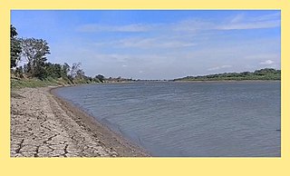
Ghodasgaon is a village in Muktainagar taluka of Jalgaon district in Maharashtra. It is located near the Purna River in Muktainagar.
North Maharashtra is a geographical region of Maharashtra State, India. The region is composed of Nashik, Dhule, Nandurbar, and Jalgaon districts. It borders the state of Gujarat to the northwest, Paschim Maharashtra to the south, Konkan to the west, and the Vidarbha and Marathwada regions of Maharashtra to the east.

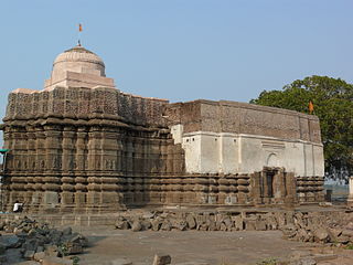
Changdeva temple is an ancient Hindu temple situated in Muktainagar taluka of Jalgaon district in the state of Maharashtra, India. It is located near its namesake, Changdeva village. The temple is on the shore of the Purna river. It is dedicated to the 12th century Yogi Saint Changdeva Maharaj.
Muktainagar taluka is a taluka in the Jalgaon district of Maharashtra, India. Its eponymous town is its administrative headquarters. The taluka is situated in the northern portion of the state.