
India is situated north of the equator between 8°4' north to 37°6' north latitude and 68°7' east to 97°25' east longitude. It is the seventh-largest country in the world, with a total area of 3,287,263 square kilometres (1,269,219 sq mi). India measures 3,214 km (1,997 mi) from north to south and 2,933 km (1,822 mi) from east to west. It has a land frontier of 15,200 km (9,445 mi) and a coastline of 7,516.6 km (4,671 mi).
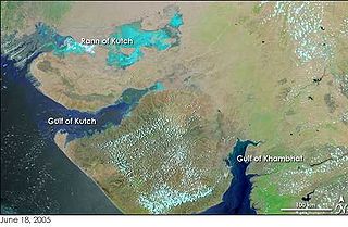
The Gulf of Kutch is located between the peninsula regions of Kutch and Saurashtra, bounded in the state of Gujarat that borders Pakistan. It opens towards the Arabian Sea facing the Gulf of Oman.

The Tapti River is a river in central India located to the south of the Narmada river that flows westwards before draining into the Arabian Sea. The river has a length of around 724 km (450 mi) and flows through the states of Maharashtra, Gujarat and Madhya Pradesh. It flows through the city of Surat, in Gujarat, and is crossed by the Magdalla, ONGC Bridge.

The Sabarmati river is one of the major west-flowing rivers in India. It originates in the Aravalli Range of the Udaipur District of Rajasthan and meets the Gulf of Khambhat of Arabian Sea after travelling 371 km (231 mi) in a south-westerly direction across Rajasthan and Gujarat. 48 km (30 mi) of the river length is in Rajasthan, while 323 km (201 mi) is in Gujarat.

Dang is a district in the southeastern part of the state of Gujarat in western India. The administrative headquarters of the district are located in Ahwa. Dang has an area of 1,764 km2 and a population of 228,291. As of 2011, it is the least populous of Gujarat's 33 districts. As per the Planning Commission, Dang is one of the most economically distressed district out of 640 districts in India. 94% of the population belongs to one of the scheduled tribes. The five Kings of Dangs are the only hereditary royals in India whose titles are currently recognized by the government owing to an agreement between the Government of India and the Dang kings in 1842.

Navsari is an administrative district in the state of Gujarat in India, with its headquarters at the city of Navsari. The district covers an area of 2,211 square kilometres and was formed in 1997 after Valsad district was split into Valsad and Navsari districts. It is the largest producer of chikoos in India.
Khambhat, also known as Cambay, is a city and the surrounding urban agglomeration in Anand district in the Indian state of Gujarat. It was once an important trading center, but its harbour gradually silted up, and the maritime trade moved to Surat. Khambat lies on an alluvial plain at the north end of the Gulf of Khambhat, noted for the extreme rise and fall of its tides, which can vary as much as thirty feet in the vicinity of Khambat. Khambat is known for its halvasan sweet, sutarfeni, akik stone and kites (patang), and for sources of oil and gas.

The Mahi is a river in western India. It rises in Madhya Pradesh and, after flowing through the Vagad region of Rajasthan, enters Gujarat and flows into the Arabian Sea. It is one of the relatively few west-flowing rivers in India, alongside the endorheic Luni River, the Sabarmati River, the Tapi River and the Narmada River. Most peninsular rivers in India flow eastward into the Bay of Bengal or northward into the Ganges River.
Navsari is the ninth biggest city in the state of Gujarat in India. It is the administrative headquarters of Navsari District. Navsari is situated between Surat & Mumbai. Navsari is a twin city of Surat. It is located 37 km south of Surat. As per 2011 Census of India, Navsari is 16th biggest city of Gujarat state. It ranked 10th most populous city of Gujarat in 1991 Census of India and 2001 Census of India. Navsari is the 25th cleanest city of India according to the Swachh Bharat Urban mission. Dandi village near Navsari was the focal point of the great Salt March led by Mahatma Gandhi during civil disobedience movement of India.

Vansda National Park, also known as Bansda National Park, is a protected area which represents the thick woodlands of the Dangs and southern Gujarat, and is situated in the Vansda tehsil, Navsari District of Gujarat state, India. Riding on the banks of Ambika River and measuring roughly 24 km2 in area, the park lies about 65 km east of the town of Chikhali on the National Highway 48, and about 80 km northeast of the city of Valsad. Vansda, the town from which the name of the park is derived, is an important trading place for the surrounding area where the majority of the population is represented by adivasis. Vansda-Waghai state highway runs through the park, so does the narrow gauge rail link connecting Waghai to Billimora.
Bilimora is a city situated on the banks of the river Ambika, in Gandevi taluka & Navsari district of Gujarat state, in India. The city comes under the purview of the Surat Metropolitan Region. The city is roughly 70 kilometres (43 mi) south of the city of Surat and is the southernmost point of the Surat Metropolitan Region and the Metropolis of Surat. It is linked to Surat by SH 6 and SH 88.

The tall-stilt mangrove belongs to the Plantae kingdom under the Rhizophoraceae family. R. apiculata is distributed throughout Australia, Guam, India, Indonesia, Malaysia, Micronesia, New Caledonia, Papua New Guinea, the Philippines, Singapore, the Solomon Islands, Sri Lanka, Taiwan, the Maldives, Thailand, Vanuatu, and Vietnam. Rhizophora apiculata is called ‘bakhaw lalaki,’ in the Philippines, "Thakafathi ތަކަފަތި" in the Maldives, 'Đước' in Vietnam, Garjan in India, as well as other vernacular names.

Odisha is one of the 28 states in the Republic of India. Odisha is located in the eastern part of the Indian peninsula and the Bay of Bengal lies to its East while Chhattisgarh shares its border in the west and north-west. The state also shares geographic boundaries with West Bengal in the north-east, Jharkhand in the north and Andhra Pradesh in the south. The state is spread over an area of 1,55,707 km2 and extends for 700 km from north to south and 500 kilometres from east to west. Its coastline is 450 km long. The state is divided into 30 districts which are further subdivided into 317 blocks called tahasil.

South Gujarat, also known as Dakshin Gujarat, is a region in the Indian state of Gujarat. The region has a wetter climate than other regions of Gujarat. The western part is almost coastal and is known as Kantha Vistar, and the eastern part is also known as Dungar Vistar, which ranges from 100 to 1000 metres, with the highest peak at Saputara in the Dang district.

Gujarat is a state in Western India. It has the India's Longest Coastline of 1214 km and It also has the one of the Largest Salt Desert in the World with the Area of 7500 Sq. km.
The Indus River Delta-Arabian Sea mangroves are a large mangrove ecoregion on the Arabian Sea coast of Sindh Province, Pakistan, and the Gulfs of Kutch and Khambhat in Gujarat, India. The mangroves are the seventh largest mangrove forest in the world.
The Gulf of Khambhat, also known as the Gulf of Cambay, is a bay on the Arabian Sea coast of India, bordering the state of Gujarat just north of Mumbai and Diu Island. The Gulf of Khambhat is about 200 km (120 mi) long, about 20 km (12 mi) wide in the north and up to 70 km (43 mi) wide in the south. Major rivers draining Gujarat are the Narmada, Tapti, Mahi and the Sabarmati, that form estuaries in the gulf.
Shetrunji River is an eastward-flowing river in Bhavnagar, Gujarat, in western India.

Purna Wildlife Sanctuary is a wildlife sanctuary in the Western Ghats mountain range, in the States of Gujarat and Maharashtra, India. In the South Gujarat, it is located between Vyara, Tapi District and Ahwa, Dang District, and in Maharashtra, it is located in Nandurbar District. Apart from the Dangs' District, it is a part of the Northern Division of the Dangs' Forest.
Dholera is a taluka in Ahmedabad district of Gujarat state in the western part of India. Situated within the Ahmedabad district, Dholera Taluka is characterized by its strategic positioning along the Gulf of Khambhat, approximately 30 kilometers south of the city of Ahmedabad. Dholera is the headquarters of this taluka.
