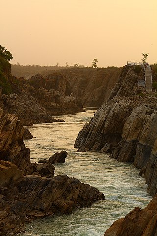
The Narmada River, previously also known as Narbada or anglicised as Nerbudda, is the 5th longest river in India and overall the longest west-flowing river in the country. It is also the largest flowing river in the state of Madhya Pradesh. This river flows through the states of Madhya Pradesh and Gujarat in India. It is also known as the "Lifeline of Madhya Pradesh and Gujarat" due to its huge contribution to the two states in many ways. The Narmada River rises from the Amarkantak Plateau in Anuppur district in Madhya Pradesh. It forms the traditional boundary between North and South India and flows westwards for 1,312 km (815.2 mi) before draining through the Gulf of Khambhat into the Arabian Sea, 30 km (18.6 mi) west of Bharuch city of Gujarat.

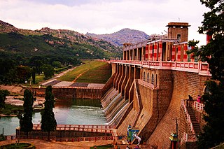
The Sardar Sarovar Dam is a concrete gravity dam built on the Narmada River near the town of Kevadiya, in Narmada District, in the Indian state of Gujarat. The dam was constructed to provide water and electricity to the Indian states of Gujarat, Madhya Pradesh, Maharashtra and Rajasthan.

Rajkot is the fourth-largest city in the Indian state of Gujarat after Ahmedabad, Vadodara, and Surat, and is in the centre of the Saurashtra region of Gujarat. Rajkot is the 35th-largest metropolitan area in India, with a population of more than 2 million as of 2021. Rajkot is the 6th cleanest city of India, and it is the 7th fastest-growing city in the world as of March 2021. The city contains the administrative headquarters of the Rajkot District, 245 km from the state capital Gandhinagar, and is located on the banks of the Aji and Nyari rivers. Rajkot was the capital of the Saurashtra State from 15 April 1948 to 31 October 1956, before its merger with Bombay State on 1 November 1956. Rajkot was reincorporated into Gujarat State on 1 May 1960.

The Indira Sagar Dam is the largest dam in India, in terms of volume of water stored in the reservoir. It is located on the Narmada River at the town of Narmada Nagar, Punasa in the Khandwa district of Madhya Pradesh in India. The foundation stone of the project was laid by the prime minister of India Indira Gandhi on 23 October 1984. The construction of the main dam started in 1992. The downstream projects of ISP are Omkareshwar, Maheshwar, and Sardar Sarovar Project. To build it, a town of 22,000 people and 100 villages was displaced.

Malampuzha Dam is the second largest dam and reservoirs in Kerala, located near Palakkad, in the state of Kerala in South India, built post independence by the then Madras state. Situated in the scenic hills of the Western Ghats in the background it is a combination of a masonry dam with a length of 1,849 metres and an earthen dam with a length of 220 metres making it the longest dam in the state. The dam is 355 feet high and crosses the Malampuzha River, a tributary of Bharathappuzha, Kerala's second longest river. There is a network of two canal systems that serve the dam's reservoir of 42,090 hectares.

The Lal Bahadur Shastri Dam is also known as Almatti Dam is a hydroelectric project on the Krishna River in North Karnataka, India which was completed in July 2005. The target annual electric output of the dam is 560 MU.

The Kalpasar Project or the Gulf of Khambhat Development Project envisages building a 30 km dam across the Gulf of Khambat in India for establishing a huge fresh water coastal reservoir for irrigation, drinking and industrial purposes. The project with 30 km sea dam will have the capacity to store 10 billion cubic meters fresh water, equating to 25% of Gujarat’s average annual rainwater flow, from the rivers like Narmada, Mahi, Dhadhar, Sabarmati, Limbdi-Bhagovo, and two other minor rivers. A 10 lane road link will also be set up over the dam, greatly reducing the distance between Saurashtra and South Gujarat. The project, which will create world's largest freshwater lake in marine environment, will cost INR90,000 crore or US$12.75 billion excluding the cost of tidal power plant. Project entails construction of the main "Kalpasar dam" across Gulf of Khambat and another Bhadbhut barrage on Narmada river, as well as a canal connecting the two.
The Krishnagiri Dam is a dam that spans the Thenpennai River by the village of Dhuduganahalli, located in Krishnagiri district, Tamil Nadu, India. The Krishnagiri Dam is also known as Krishnagiri ReservoirProject (KRP) Dam. The KRP Dam is located 7 km (4.3 mi) from Krishnagiri, between Dharmapuri and Krishnagiri which irrigates thousands of acres of land around Krishnagiri. The Dam is operational from 10 November 1957, inaugurated by the Chief Minister of Tamil Nadu K. Kamaraj.

Dholi Dhaja Dam across the Bhogavo River is located near Surendranagar city and in the urban area of Surendranagar Dudhrej Municipality in the state of Gujarat, India.
Nayka Dam is an earthen dam on the Bhogavo River located near Surendranagar in the Indian state of Gujarat. Nayka is a major source of water and helps with flood control.
Narmada Valley Development Authority (NVDA) concerns Narmada River, the river of Madhya Pradesh. With 87% of its catchment area lying in Madhya Pradesh, it becomes all the more important for the state to exploit this enormous water resource. It was with this motto in mind that the Narmada Valley Development Authority (NVDA) was formed by the government of MP on 9 August 1985. NVDA oversees all major development projects in the Narmada Basin. The body also ensures that proper rehabilitation is provided to the displaced, and the negative impacts on environment are minimized by taking appropriate measures.
Upparu River is a river flowing in the Tirupur district of the Indian state of Tamil Nadu.

The Narmada Canal is a contour canal in Western India that brings water from the Sardar Sarovar Dam to the state of Gujarat and then into Rajasthan state. The main canal has a length of 532 kilometres (331 mi). It is the second longest canal in India and the largest canal by water carrying capacity. The main canal is connected with 42 branch canals providing irrigation to 2,129,000 hectares farmland. The canal is designed to transfer 9.5 million acre-feet water annually from the Narmada Basin to areas under other river basins in Gujarat and Rajasthan..
Penna Ahobilam Balancing Reservoir(PABR) is an irrigation project located across Penna River in Anantapur district of Andhra Pradesh state in India. Anantapur city gets its drinking water from the PABR. The reservoir with live storage capacity of 305 million cubic metres is mainly fed by Tungabhadra high level canal originating from the Tungabhadra Dam to the extent of 10 Tmcft water. A 20 MW hydro electric power station is also constructed at the dam site.
Wyra Reservoir is a medium irrigation project constructed across the Wyra River, a tributary of Krishna River. The reservoir is located next to the Wyra town, Khammam District, Telangana. It is one of the tourist attractions in Khammam district. This Wyra reservoir was constructed in 1930, and was inaugurated by Dr.Sarvepalli Radhakrishnan former President of India. It provides drinking water to eight mandalas around Wyra. Hundreds of hectares of land is cultivated using water from Wyra reservoir. It is also well known for its good fishing and the green hills around it. The project provides water to 17,391 acres for irrigation. The reservoir also gets water from Nagarjunasagar left canal.

The Purna River is a major left-bank tributary of Godavari River originating in the Ajanta Range of hills in Aurangabad District, Maharashtra.The river lies in the rain shadow region of Maharashtra, on the Deccan Plateau, flowing through the districts of Aurangabad, Buldana, Jalna, Hingoli and Parbhani with a large catchment area measuring about 15,579 km2. This enormous catchment area is often tagged as a sub-basin of Godavari River and along with its tributaries forms a dendritic drainage pattern. It is a prime river in the Marathwada region of Maharashtra running for about 373 km before it converges with Godavari River south of Purna city in the Parbhani district.

Sardhar is a village located on the Rajkot to Bhavnagar highway and 30 km away from Rajkot in the state of Gujarat, India.

Saurashtra Narmada Avtaran Irrigation (SAUNI) is a project launched by Indian Prime Minister Narendra Modi with objective of filling 115 major dams by diverting floodwaters overflowing from the Sardar Sarovar Dam across the Narmada river to the drought areas in Saurashtra region of Gujarat state of India.

The Wyra River is one of the tributaries of Munneru River, which is itself a major tributary of Krishna river. It originates at Wyra Reservoir near Wyra village, which was named after the reservoir.

