Krishna River

Last updated

Krishna River
Back Water View.jpg
Krishna River gorge by Srisailam, Andhra Pradesh, India
Krishna.png
Path of the Krishna in the peninsular India ()
Location
CountryIndia
State Maharashtra, Karnataka, Telangana, Andhra Pradesh
Region South India
Physical characteristics
SourceNear Mahabaleshwar, Jor village, Dist- Satara
  location Satara district, Maharashtra, India
  coordinates 17°59′19″N73°38′17″E / 17.98861°N 73.63806°E / 17.98861; 73.63806
  elevation914 m (2,999 ft) Geographic headwaters
Mouth Bay Of Bengal
  location
Hamsaladeevi, Krishna district, Andhra Pradesh, India
  coordinates
15°44′06″N80°55′12″E / 15.73500°N 80.92000°E / 15.73500; 80.92000 [1]
  elevation
0 m (0 ft)
Length1,400 km (870 mi) or 1,290 km (800 mi)approx. [2]
Basin size258,948 km2 (99,980 sq mi)
Discharge 
  average2,213 m3/s (78,200 cu ft/s)
Discharge 
  location Vijayawada (1901–1979 average),
max (2009), min (1997)
  average1,641.74 m3/s (57,978 cu ft/s)
  minimum13.52 m3/s (477 cu ft/s)
  maximum31,148.53 m3/s (1,100,000 cu ft/s) [3]
Basin features
Tributaries 
  left Yerla, Bhima, Dindi, Musi, Paleru, Munneru
  rightKudali (Niranjna) Venna, Koyna, Panchganga, Dudhaganga, Ghataprabha, Malaprabha, Tungabhadra
Down stream view of Prakasam Barrage. Krishna River near Vijayawada Andhra Pradesh India.jpg
Down stream view of Prakasam Barrage.
Krishna River near Vijayawada Krishna River.jpg
Krishna River near Vijayawada

The Krishna River is a river in the Deccan plateau and is the third-longest river in India, after the Ganges and Godavari. It is also the fourth-largest in terms of water inflows and river basin area in India, after the Ganges, Indus and Godavari. [4] The river, also called Krishnaveni, is 1,400 kilometres (870 mi) long and its length in Maharashtra is 282 kilometres. [5] It is a major source of irrigation in the Indian states of Maharashtra, Karnataka, Telangana and Andhra Pradesh. [6]

Contents

Course

The Krishna River originates in the Western Ghats near Mahabaleshwar at an elevation of about 1,300 metres (4,300 ft), in the state of Maharashtra in central India. From Mahabaleshwar it flows to the town of Wai and continues east until it empties into the Bay of Bengal. [7] The Krishna River passes through the Indian states of Maharashtra, Karnataka, Andhra Pradesh, and Telangana. [8] It is around 1,400 kilometres (870 mi) in length, of which 305 km (190 mi) flows in Maharashtra, 483 km (300 mi) in Karnataka and 612 km (380 mi) in Andhra Pradesh. [9]

Tributaries

Panoramic view of Ujjani or Bhima Dam Full doownstream view of the Bhima or Ujjani Dam.jpg
Panoramic view of Ujjani or Bhima Dam
Tungabhadra Dam near Hosapete TungabhadraRiver Dam.jpg
Tungabhadra Dam near Hosapete

The Krishna River has 13 major tributaries. [9] Its principal tributaries include the Ghataprabha River, Malaprabha River, Bhima River, Tungabhadra River and Musi River. [9] The Tungabhadra River has a catchment area of 71,417 km2 (27,574 sq mi) and a length of 531 km (330 mi). [9] The Bhima River is the longest tributary of the Krishna River. [7] It has a total length of 861 km (535 mi) and catchment area of 70,614 km2 (27,264 sq mi). [9]

Three tributaries, Panchganga, Warna and Yerla, meet the Krishna River near Sangli. Hindus consider these places very holy. It is said that Lord Dattatreya spent some of his days at Audumber on the banks of river Krishna.

Kudalasangama, North Karnataka Kudalasangama 7.jpg
Kudalasangama, North Karnataka

Kudalasangama [10] (also written as Kudala Sangama) is located about 15 kilometres (9.3 mi) from the Almatti Dam in Bagalkot district of Karnataka state. The Krishna and Malaprabha rivers merge here. The Aikya Mantapa or the holy Samādhi of Basavanna, the founder of the Lingayat sect of Hindu religion along with Linga, which is believed to be self-born ( Swayambhu ), is here and river flow east towards Srisailam (another pilgrim center) Andhra Pradesh.

Sangameswaram of Kurnool district in Andhra Pradesh is a famous pilgrim center for Hindus where Tungabhadra and Bhavanasi rivers join the Krishna River. The Sangameswaram temple is now drowned in the Srisailam reservoir, and visible for devotees only during summer when the reservoir's water level comes down. [11] [12]

Krishna Basin

Drainage Basin of Krishna

  Bhima Upper (17.58%)
  Bhima Lower (9.29%)
  Krishna Upper (21.39%)
  Krishna Middle (8.73%)
  Krishna Lower (15.50%)
  Tungabhadra Upper (11.20%)
  Tungabhadra Lower (16.31%)

The Krishna Basin extends over an area of 258,948 km2 (99,980 sq mi) which is nearly 8% of the total geographical area of the country. This large basin lies in the states of Karnataka (113,271 km2), Telangana, Andhra Pradesh (76,252 km2) and Maharashtra (69,425 km2). [13] It is the fifth largest basin in India. [7]

Most of this basin comprises rolling and undulating country, except for the western border, which is formed by an unbroken line of the Western Ghats. The important soil types found in the basin are black soils, red soils, laterite and lateritic soils, alluvium, mixed soils, red and black soils and saline and alkaline soils.

An average annual surface water potential of 78.1 km3 has been assessed in this basin. Out of this, 58.0 km3 is utilizable water. [14] Culturable area in the basin is about 203,000 km2 (78,000 sq mi), which is 10.4% of the total cultivable area of the country. As the water availability in the Krishna River was becoming inadequate to meet the water demand, Godavari River is linked to the Krishna River by commissioning the Polavaram right bank canal with the help of Pattiseema lift scheme in the year 2015 to augment water availability to the Prakasam Barrage in Andhra Pradesh. [15] The irrigation canals of Prakasam Barrage form part of National Waterway 4. The Krishna-Godavari delta known as "Rice Granary of India." [16]

Mineral deposits

Krishna close to its origin at Menawali, near Wai, Satara district, Maharashtra.18th century, Maratha statesman, Nana Fadnavis built the Ghat and a palace here.This location has been used in many Hindi movies. Menavali pan.jpg
Krishna close to its origin at Menawali, near Wai, Satara district, Maharashtra.18th century, Maratha statesman, Nana Fadnavis built the Ghat and a palace here.This location has been used in many Hindi movies.

Krishna River basin is endowed with rich mineral deposits such as oil and gas, coal, iron, limestone, dolomite, gold, granite, laterite, uranium, diamonds, etc. The following are the few noted deposits:

Flora and fauna

Widespread area near to the Krishna River holds the rich flora and fauna. The last surviving Mangrove forests in the Krishna estuary have been declared as the Krishna Wildlife Sanctuary. The sanctuary is the home to the large number of resident and migratory birds. Fishing cats, otters, Estuarine crocodiles, spotted deer, sambar deer, blackbucks, snakes, lizards and jackals can also be spotted in the sanctuary. The sanctuary also supports rich vegetation with plants like Rhizophora, Avicennia, and Aegiceros. The following are few other wildlife sanctuaries located in the Krishna basin.

Waterfalls

Gokak Falls on Ghataprabha River Gokak Falls.jpg
Gokak Falls on Ghataprabha River

The following are few other waterfalls located in the river basin

Water outflows to the sea

The yearly water outflows to the sea in a water year from 1 June 2003 to 31 May 2022 (19 years) are given below

Waterflow to the sea [17]
Water year3-0404-0505-0606-077-088-0909-1010–1111–1212–1313–1414–1515–1616–1717–1818–1919–2020–2121–22
Water outflows (tmcft)51411396888529643740721556394739550397981252485

Interstate water sharing

At present, the award of Bachawat tribunal dated 31 May 1976 is applicable for sharing the water available in the river among the riparian states. The Brijesh Kumar tribunal award given on 29 November 2013 is challenged by Andhra Pradesh in the Supreme Court and the case is pending since then. [18] The newly created state of Telangana also approached the Supreme Court demanding a fresh tribunal hearing to secure its water needs on equitable basis. [19]

Even though the river does not flow through Tamil Nadu, the Telugu Ganga Project is a canal system that brings Krishna River water to that state's capital city of Chennai with the agreement of all basin states.

Places and temples

Pre Historic sites of Middle Krishna-Tungabhadra Valley in Telangana, Andhra Pradesh Pre Historic Mid Krishna-Tungabhadra Valley sites.jpg
Pre Historic sites of Middle Krishna-Tungabhadra Valley in Telangana, Andhra Pradesh

This river is revered by Hindus as sacred. The river is also believed to remove all sins of people by taking a bath in this river. The centre of attraction is the Krishna Pushkaram fair which is held once in twelve years on the banks of the Krishna River. There are many pilgrimage places in Maharashtra, Karnataka, Telangana and Andhra Pradesh on the course of the river.[ citation needed ] The first holy place on the river Krishna is at Wai, known for the Mahaganpati Mandir and Kashivishweshwar temple. It has seven ghats along the river. Temples like Dattadeva temple, which is revered by the people of Maharashtra, are located on the banks of Krishna at Narsobawadi , Bhilawdi Audumbar near Sangli. Yadur is one of the important holy places in Karnataka which is located on the bank of Krishna. Veerabhadra temple is a famous temple. Many devotees visit this place from Maharashtra and Andhra Pradesh. Also, located on the banks of the river Krishna is the Sangameshwar Shiva temple at Haripur. Some of the other temples are the Kanaka Durga Temple in Vijayawada, Ramling temple near Sangli, Mallikarjuna Jyotirlinga (Srisailam), Amareshwara Swamy Temple, Vedadri Narasimha Temple, Vadapalli temple in Nalgonda, Dattadeva temple, and Sangameshwara Shiva temples at Alampur and Gadwal in Telangana.[ citation needed ]

Bhilawadi town in Maharashtra has a large stone structure constructed across Krishna River bank, also known as Krishna Ghat. This structure also includes one large and one small temple constructed in the middle of the river. This structure is believed to be constructed in 1779. [20]

Bridges

Panorama of Prakasam Barrage and Railway bridges on Krishna near Vijayawada Panorama of Prakasam Barrage and Railway bridges.jpg
Panorama of Prakasam Barrage and Railway bridges on Krishna near Vijayawada

The Krishna River is spanned by several bridges along its course, some of which are listed below.

In October 2009, heavy floods occurred, isolating 350 villages and leaving millions homeless, [22] which is believed to be first occurrence in 1000 years. The flood resulted in heavy damage to Kurnool, Mahabubnagar, Guntur, Krishna and Nalagonda Districts. The entire city of Kurnool was immersed in approximately 10 ft (3 m) water for nearly 3 days. [23]

Water inflow of 1,110,000 cu ft/s (31,000 m3/s) was recorded at the Prakasam Barriage, which surpassed the previous record of 1,080,000 cu ft/s (31,000 m3/s) recorded in the year 1903. [24] Krishna River is the second largest east flowing river of the peninsula. The flood waters of Krishna and Godavari rivers can be fully utilized by exporting water to other east flowing peninsular rivers up to Vaigai River in Tamil Nadu by constructing a coastal reservoir on the Bay of Bengal sea area.

Dams

NSRS Srisailam Dam NSRS Srisailam Dam.jpg
NSRS Srisailam Dam
Nagarjuna Sagar Dam Gates view Nagarjuna Sagar Dam Gates view.jpg
Nagarjuna Sagar Dam Gates view

There are many dams constructed across the Krishna River. [25]

Hydroelectric power stations

The Krishna River is one of the rivers whose water energy is harnessed to a large extent by various hydro electric power stations in India. [26] The following is the list of hydro electric power stations excluding small and medium installations.

Almatti Dam with its right bank power house Alamatti dam.JPG
Almatti Dam with its right bank power house
Name of the projectRated Power (in MW)Comments
Koyna Hydroelectric Project 1,920
Mulshi Dam 300Power station with Pumped-storage hydroelectricity units
Thokarwadi Dam 72
Ujjani Dam 12Power station with Pumped-storage hydroelectricity units
Almatti Dam 290
Bhadra Dam 39
Tungabhadra Dam 127
Jurala Hydroelectric Project 240
Lower Jurala Hydro Electric Project 240
Srisailam Dam 1,670Power station with Pumped-storage hydroelectricity units
Nagarjuna Sagar Dam 960Power station with Pumped-storage hydroelectricity units
Nagarjuna Sagar tail pond 50
Pulichinthala Dam 120

Pollution

Most of the years, the river water is not joining the sea due to full utilisation of water mainly in agriculture. [27] [28] Closed river basin of Krishna means that the river ecosystem is on the verge of death. [29] [30] The river receives the waste from the large number of cities and the river basin population has increased to 80 million enhancing pollution load many folds into the river. Adequate average and minimum continuous environmental flows to the sea are not taking place in most of the years constricting salt export and leading to formation of saline and sodic alkaline soils in the lower reaches of the river basin. [31] [32] High alkalinity water is discharged from the ash dump areas of many coal fired power stations into the river which further increases the alkalinity of the river water whose water is naturally of high alkalinity since the river basin is draining vast area of basalt rock formations. [33] The following are the few coal fired power stations located in the river basin

Thermal power stations in Krishna River basin
Name of Power StationRated Power (in MW)
Vijayawada Thermal Power Station 1,760
Raichur Thermal Power Station 1,470
Bellary Thermal Power station 1,700
Yermarus Thermal Power Station 1,600
Solapur Super Thermal Power Station 1,320
Kudgi Super Thermal Power Project 2,400
Yadadri Thermal Power Plant 4000

See also

Related Research Articles

<span class="mw-page-title-main">Godavari River</span> River in south-central India

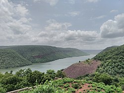
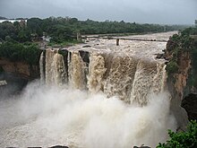
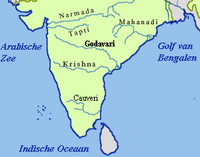
The Godavari is India's second longest river after the Ganga River and drains the third largest basin in India, covering about 10% of India's total geographical area. Its source is in Trimbakeshwar, Nashik, Maharashtra. It flows east for 1,465 kilometres (910 mi), draining the states of Maharashtra (48.6%), Telangana (18.8%), Andhra Pradesh (4.5%), Chhattisgarh (10.9%) and Odisha (5.7%). The river ultimately empties into the Bay of Bengal through an extensive network of distributaries. Measuring up to 312,812 km2 (120,777 sq mi), it forms one of the largest river basins in the Indian subcontinent, with only the Ganga and Indus rivers having a larger drainage basin. In terms of length, catchment area and discharge, the Godavari is the largest in peninsular India, and had been dubbed as the Dakshina Ganga.

<span class="mw-page-title-main">Telangana</span> State in southern India

Telangana is a state in India situated in the southern part of the Indian peninsula on the high Deccan Plateau. It is the eleventh-largest state and the twelfth-most populated state in India as per the 2011 census. On 2 June 2014, the area was separated from the northwestern part of United Andhra Pradesh as the newly formed state of Telangana, with Hyderabad as its capital.

<span class="mw-page-title-main">Tungabhadra River</span> River in southern India

The Tungabhadra River is a river in India that starts and flows through the state of Karnataka during most of its course, Andhra Pradesh and ultimately joining the Krishna River near Murvakonda in Andhra Pradesh

<span class="mw-page-title-main">Bhima River</span> Major river in southwest India

The Bhima River is a major river in Western India and South India. It flows southeast for 861 kilometres (535 mi) through Maharashtra, Karnataka, and Telangana states, before joining the Krishna River. After the first sixty-five kilometers in a narrow valley through rugged terrain, the banks open up and form a fertile agricultural area which is densely populated.

<span class="mw-page-title-main">Godavari River Basin Irrigation Projects</span>

The Godavari River has its catchment area in seven states of India: Maharashtra, Telangana, Chhattisgarh, Madhya Pradesh, Andhra Pradesh, Karnataka and Odisha. The number of dams constructed in Godavari basin is the highest among all the river basins in India. Nearly 350 major and medium dams and barrages had been constructed in the river basin by the year 2012.

<span class="mw-page-title-main">Nizam Sagar Dam</span> Dam in Telangana, India

Nizam Sagar Dam is an Indian dam named after the Nizam of Hyderabad. It is a reservoir constructed across the Manjira River, a tributary of the Godavari River, between Achampet and BanjePally villages of the Kamareddy district in Telangana, India. It is located at about 144 km (89 mi) north-west of Hyderabad. Nizam Sagar is the oldest dam in the state of Telangana.

<span class="mw-page-title-main">Sriram Sagar Project</span> Dam in Telangana, India

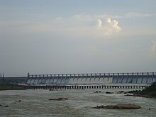
The Sriram Sagar Project is also known as the Pochampadu Project is an Indian flood-flow project on the Godavari. The Project is located in Nizamabad district, 3 km away from National Highway 44. It has been described by The Hindu as a "lifeline for a large part of Telangana".

<span class="mw-page-title-main">Nagarjuna Sagar Dam</span> Dam in Andhra Pradesh & Nalgonda district, Telangana

Nagarjuna Sagar Dam is a masonry dam across the Krishna River at Nagarjuna Sagar which straddles the border between Palnadu district in Andhra Pradesh and Nalgonda district in Telangana. The dam provides irrigation water to the districts of Palnadu, Guntur, Nalgonda, Prakasam, Khammam, Krishna, and parts of West Godavari. It is also a source of electricity generation for the national grid.

<span class="mw-page-title-main">Krishna Water Disputes Tribunal</span> Indian tribunal

Government of India constituted a common tribunal on 10 April 1969 to adjudicate the river water utilization disputes among the river basin states of Krishna and Godavari rivers under the provisions of Interstate River Water Disputes Act – 1956. The common tribunal was headed by Sri RS Bachawat as its chairman with Sri DM Bhandari and Sri DM Sen as its members. Krishna River basin states Maharashtra, Karnataka and old Andhra Pradesh insisted on the quicker verdict as it had become more expedient for the construction of irrigation projects in Krishna basin. So the proceedings of Krishna Water Disputes Tribunal (KWDT) were taken up first separately and its final verdict was submitted to GoI on 27 May 1976.

<span class="mw-page-title-main">Geography of Karnataka</span>

The Indian State of Karnataka is located between 11°30' North and 18°30' North latitudes and between 74° East and 78°30' East longitude.It is situated on a tableland where the Western Ghats and Eastern Ghats converge into the complex, in the western part of the Deccan Peninsular region of India. The State is bounded by Maharashtra and Goa States in the north and northwest; by the Lakshadweep Sea in the west; by Kerala in the south-west and Tamil Nadu in the south and south-east, Andhra Pradesh in the south-east and east and Telangana in the north-east. Karnataka extends to about 850 km (530 mi) from north to south and about 450 km (280 mi) from east to west.

<span class="mw-page-title-main">Central Deccan Plateau dry deciduous forests</span>

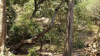
The Central Deccan Plateau dry deciduous forests in Western and Southern India, containing large protected areas of natural tiger habitat.

<span class="mw-page-title-main">Freshwater ecology of Maharashtra</span>

The state of Maharashtra in India has several major river systems including those of the Narmada, Tapti, Godavari and Krishna rivers. The ecology of these rivers and associated wetlands is covered in this article.

<span class="mw-page-title-main">Geography of South India</span> Overview of the geography of South India

The Geography of South India comprises the diverse topological and climatic patterns of South India. South India is a peninsula in the shape of a vast inverted triangle, bounded on the west by the Arabian Sea, on the east by the Bay of Bengal and on the north by the Vindhya and Satpura ranges.

<span class="mw-page-title-main">Polavaram Project</span> Dam in Eluru district, Andhra Pradesh

The Polavaram Project is an under construction multi-purpose irrigation project on the Godavari River in the Eluru District and East Godavari District in Andhra Pradesh. The project has been accorded National project status by the Central Government of India. Its reservoir back water spreads up to the Dummugudem Anicut and approx 115 km on Sabari River side. Thus back water spreads into parts of Chhattisgarh and Odisha States. It gives major boost to tourism sector in Godavari Districts as the reservoir covers the famous Papikonda National Park, Polavaram hydro electric project (HEP) and National Waterway 4 are under construction on left side of the river. It is located 40 km to the upstream of Sir Arthur Cotton Barrage in Rajamahendravaram City and 25 km from Rajahmundry Airport.

The Pranahita Chevella Lift Irrigation Project is a lift irrigation project to harness the water of Pranahita tributary of Godavari River for use in the Telangana state of India. The river water diversion barrage across the Pranahita River is located at Thammidihatti village in Komaram Bheem district of Telangana. This lift canal is an inter river basin transfer link by feeding Godavari River water to Krishna River basin. The chief ministers of Telangana and Maharashtra states reached an agreement in 2016 to limit the full reservoir level (FRL) of the barrage at 148 m msl with 1.85 tmcft storage capacity. In the year 2016, this project is divided into two parts. The scheme with diversion canal from the Thammmidihatti barrage to connect to existing Yellampalli reservoir across the Godavari River is presently called Pranahita barrage lift irrigation project. This scheme is confined to providing irrigation facility to nearly 2,00,000 acres in Adilabad district using 44 tmcft water.

<span class="mw-page-title-main">Rajiv Dummugudem Lift Irrigation Scheme</span>

Rajiv Dummugudem Lift Irrigation Scheme is a lift irrigation scheme under execution which are located near Dummugudem, Khammam district in Telangana, India. There are three lift irrigation schemes by names Rajiv Dummugudem lift irrigation scheme, Indirasagar Rudrammakota Dummugudem lift irrigation scheme and Dummugudem to Sagar tail pond canal project. Rajiv Dummugudem lift irrigation scheme starting at 17°54′05″N80°52′45″E is planned to supply irrigation water for 200,000 acres in Khammam and Warangal districts drawing Godavari River water from the Dummugudem pond. Indira Dummugudem lift irrigation scheme starting at 17°33′49″N81°14′49″E is planned to supply irrigation water for 200,000 acres in Khammam, Krishna and West Godavari districts drawing Godavari River water from the back waters of Polavaram reservoir.

<span class="mw-page-title-main">Godavari Water Disputes Tribunal</span> Tribunal created by the government of India

The Government of India (GoI) constituted a common tribunal on 10 April 1969 to solve the river water utilization disputes about the river basin states of Godavari and Krishna rivers under the provisions of Interstate River Water Disputes Act – 1956. The common tribunal was headed by Sri RS Bachawat as its chairman with Sri DM Bhandari and Sri DM Sen as its members. Godavari river basin spreads through the states of Telangana (TS), Maharashtra (MR), Orissa, old Madhya Pradesh {later bifurcated into present Madhya Pradesh (MP) and Chhattisgarh}, Karnataka (K) and Andhra Pradesh (AP). Krishna river basin states Maharashtra, Karnataka and Andhra Pradesh insisted on the quicker verdict as it had become more expedient for the construction of irrigation projects in Krishna basin. So the Godavari Water Disputes Tribunal (GWDT) could not proceed till the Krishna Water Disputes Tribunal final verdict was submitted to GoI on 27 May 1976.

<span class="mw-page-title-main">Nagarjuna Sagar tail pond</span> Reservoir in India

Nagarjuna Sagar tail pond is a multipurpose reservoir located 21 km downstream from the Nagarjuna Sagar Dam across the Krishna River near Satrasala in Nalgonda district, India. Its gross water storage capacity is 6 Tmcft. The reservoir water spread area extends up to the toe of the Nagarjuna Sagar dam. The project was completed by July 2014.

<span class="mw-page-title-main">Munneru River</span> River in India

Munneru is a left tributary of the Krishna River. It originates in Warangal District of Telangana, India and flows in the districts of Khammam District and Krishna District. The river is named after Rishi Maudgalya, who is said to have created this river with his spiritual power and performed a penance ritual in Khammam.

Jogulamba Barrage is a proposed barrage across Krishna River with full pond level (FPL) 274m. It would be located at Veltoor village, Peddamandadi mandal, Wanaparthy district, Telangana, India. This barrage is proposed to divert 3 TMC of water via lift to Yedula Reservoir being built as part of Palamuru-Rangareddy Lift Irrigation Scheme. This would also provide water for Dindi Lift Irrigation Project and Mahatma Gandhi Kalwakurthy Lift Irrigation Scheme.

References

  1. Krishna at GEOnet Names Server
  2. "Home | Know India: National Portal of India". Archived from the original on 19 August 2017.
  3. Jonathan, P. Samuel (15 August 2019). "For Krishna river, it's always October". The Hindu. Archived from the original on 7 November 2020. Retrieved 19 August 2019.
  4. "River Basins of India". Archived from the original on 27 June 2022. Retrieved 7 May 2022.
  5. Havale, Professor Baliram. Lakshyawedha Samany dnyan/ G.K part – 1 (in Marathi). Aurangabad, India: Sahyadri Publication. p. 72.
  6. "Map of Krishna River basin" (PDF). Archived (PDF) from the original on 6 August 2017. Retrieved 27 March 2015.The Krishna is the second largest east flowing peninsular river. It originates near Mahabaleshwar, Jor village (Sahayadri), Maharastra. It flows through Karnataka before entering Telangana.
  7. 1 2 3 Singh, Dhruv Sen (2018). The Indian rivers : scientific and socio-economic aspects. Singapore: Springer. p. 340.
  8. Harini, P.; Sahadevan, Dinesh Kumar; Das, I. C.; Manikyamba, C.; Durgaprasad, M.; Nandan, M. J. (2018). "Regional Groundwater Assessment of Krishna River Basin Using Integrated GIS Approach". Journal of the Indian Society of Remote Sensing. 46 (9): 1365–1377. Bibcode:2018JISRS..46.1365H. doi:10.1007/s12524-018-0780-4. S2CID   134500302.
  9. 1 2 3 4 5 Jain, S. K.; Agarwal, Pushpendra K.; Singh, V. P. (2007). Hydrology and water resources of India. Dordrecht: Springer. pp. 641–643. Bibcode:2007hwri.book.....J.
  10. "Kudala Sangama". Archived from the original on 23 March 2010. Retrieved 8 September 2008.
  11. Srisailam project manual
  12. Kumar, Narendra (1 August 2021). "Sangameshwara Swamy temple rarely visible". www.thehansindia.com. Archived from the original on 18 February 2023. Retrieved 18 February 2023.
  13. "Krishna basin status report, March 2014" (PDF). Archived (PDF) from the original on 17 November 2015. Retrieved 27 March 2015.
  14. IWMI Research Report 83. "Spatial variation in water supply and demand across river basins of India" (PDF). Archived (PDF) from the original on 4 March 2016. Retrieved 23 June 2015.{{cite web}}: CS1 maint: numeric names: authors list (link)
  15. "How the Krishna went dry?". The Hindu . Archived (PDF) from the original on 4 March 2016. Retrieved 13 January 2018.
  16. Nageswara Rao, Kakani; Rao, Kakani Nageswara; Saito, Yoshiki; Nagakumar, K. Ch V.; Demudu, G.; Basavaiah, N.; Rajawat, A. S.; Tokanai, Fuyuki; Kato, Kazuhiro; Nakashima, Rei (2012). "Holocene environmental changes of the Godavari Delta, east coast of India, inferred from sediment core analyses and AMS 14C dating". Geomorphology. 175–176: 163–175. Bibcode:2012Geomo.175..163N. doi:10.1016/j.geomorph.2012.07.007. Archived from the original on 7 December 2021. Retrieved 18 December 2020.
  17. "Reservoir Storage Monitoring System". Archived from the original on 21 April 2021. Retrieved 23 June 2022.
  18. Hindu daily dated (17 September 2011). "Court: do not publish KWDT-II decision". The Hindu. Archived from the original on 18 January 2021. Retrieved 5 November 2012.
  19. "T-State wants tribunal to adjudicate water disputes". The Hindu. 10 July 2014. Archived from the original on 6 April 2021. Retrieved 12 July 2014.
  20. "पलूस तालुका" (PDF). www.zpsangli.com. Archived from the original (PDF) on 19 July 2020. Retrieved 2 October 2023.
  21. Angadi, Jagadish (11 May 2019). "Exploring past marvels along the passage". Deccan Herald. Archived from the original on 18 February 2023. Retrieved 18 February 2023.
  22. "Flooding along the Krishna River: Natural Hazards". earthobservatory.nasa.gov. 5 October 2009. Archived from the original on 21 February 2017. Retrieved 11 October 2009.
  23. "Agony of Floods: Flood Induced Water Conflicts in lndia[sic]" (PDF). Archived from the original (PDF) on 3 July 2017. Retrieved 8 February 2016.
  24. "Managing historic flood in the Krishna river basin in the year 2009". Archived from the original on 26 October 2017. Retrieved 11 October 2015.
  25. "Headworks (Dam, Barrage, Weir, Anicut, Lift)". Archived from the original on 21 September 2017. Retrieved 27 September 2017.
  26. "Power Houses in Krishna Basin". Archived from the original on 18 August 2016. Retrieved 27 March 2015.
  27. J. Keller, A. Keller and G. Davids. "River basin development phases and implications of closure" (PDF). Archived from the original (PDF) on 19 October 2013. Retrieved 25 August 2012.
  28. "IWMI Research report nos # 1, 3, 14, 56, 72, 83, 107, 111, 121, 123, 125 etc". Archived from the original on 6 June 2017. Retrieved 25 August 2015.
  29. "Technology Breakthroughs for Global water security" (PDF). Archived (PDF) from the original on 30 October 2018. Retrieved 20 October 2018.
  30. "Do not kill a river". 14 April 2016. Archived from the original on 13 August 2017. Retrieved 20 April 2016.
  31. Oregon State University, USA. "Managing irrigation water quality" (PDF). Archived (PDF) from the original on 3 July 2017. Retrieved 28 August 2012.
  32. "Alkalinity and salinity bane of soil in T state". The Times of India . 7 August 2015. Archived from the original on 2 January 2017. Retrieved 23 October 2015.
  33. "Chemical weathering in the Krishna Basin and Western Ghats of the Deccan Traps, India" (PDF). Archived (PDF) from the original on 21 July 2011. Retrieved 30 October 2015.