Uttara Kannada is a district in the Indian state of Karnataka. It is a major coastal district of Karnataka, and is the third largest district in Karnataka. It is bordered by the state of Goa and Belagavi districts to the north, Dharwad District and Haveri District to the east, Shivamogga District, and Udupi District to the south, and the Laccadive Sea to the west.

Shimoga, officially known as Shivamogga, is a city and the district headquarters of Shimoga district in the central part of the state of Karnataka, India. The city lies on the banks of the Tunga River. Being the gateway for the hilly region of the Western Ghats, the city is popularly nicknamed the "Gateway of Malnad". The population of Shimoga city is 322,650 as per 2011 census. The city has been selected for the Smart Cities project, standing in the fourth position in the state and 25th in the country as of November 2020.

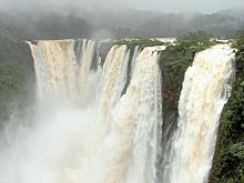
Sharavati is a river which originates and flows entirely within the state of Karnataka in India. It is one of the few westward flowing rivers of India and a major part of the river basin lies in the Western Ghats. The famous Jog Falls, located about 25 km from Siddapura, is formed by this river. The river itself and the regions around it are rich in biodiversity and are home to many rare species of flora and fauna.

Sirsi is a city and a taluk headquarter in Uttara Kannada district of Karnataka state in India. It was also known as Kalyana Pattana during the Sonda Dynasty. It is a tourist destination with evergreen forest and waterfalls and is also a commercial centre. The main businesses around the city are mostly subsistence and agriculture-based. Areca nut or betel nut, locally known as Adike, is the primary crop grown in the nearby villages, making it one of the major trading centres for areca nut. The region is also known for spices such as cardamom, pepper, betel leaves, and vanilla. The major food crop is paddy.

Shimoga district, officially known as Shivamogga district, is a district in the Karnataka state of India. A major part of Shimoga district lies in the Malnad region or the Sahyadri. Shimoga city is its administrative centre. Jog Falls view point is a major tourist attraction. As of 2011 Shimoga district has a population of 17,52,753. There are seven taluks: Soraba, Sagara, Hosanagar, Shimoga, Shikaripura, Thirthahalli, and Bhadravathi. Channagiri and Honnali were part of Shimoga district until 1997 when they became part of the newly formed Davanagere district.
Hosanagara is a panchayat town in Shimoga district in the Indian state of Karnataka. It is nested in western ghats of India. The World Cattle Conference with main emphasis on cow was held in month of April 2007 in Hosanagar. The different uses of cow were exhibited. Near Hosanagar there is a mutt named Sri Ramachandrapura Math, 6 km from the town.
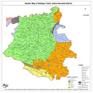
Siddapur Taluk is the destination of world famous Jog Falls. It is a part of Uttara Kannada district, Karnataka, India and is located in the midst of forest areas of Western Ghats and it is also a part of Malenadu. The taluk is full of greenery, hills and arecanut gardens developed in the valleys’. The taluk headquarters is Siddapur. Sirsi is the nearest city,
Varahi River originate and flows through Western Ghats in the Indian state of Karnataka. It is also known as Halady or Haladi river in downstream areas. It joins the Arabian sea after flowing through places like Halady, Basrur, Kundapura and Gangolli. It joins with the Souparnika River, Kedaka River, Chakra River, and Kubja River which are known by Panchagangavalli River and merges into the Arabian Sea. Pancha means five in Kannada and Samskrita and Ganga means river. According to mythology, Varaha is one of the incarnations of Lord Vishnu. Varahi is the sister of lord Varaha-vishnu

Karnataka, the sixth largest state in India, has been ranked as the third most popular state in the country for tourism in 2014. It is home to 507 of the 3600 centrally protected monuments in India, second only to Uttar Pradesh. The State Directorate of Archaeology and Museums protects an additional 752 monuments and another 25,000 monuments are yet to receive protection.

The Linganamakki Dam was constructed by the Karnataka State Government in 1964. Located in the Kargal village of Sagara taluk, the dam has a length of 2.74 kilometres (1.70 mi) stretching across the Sharavathi river. It is located about 9 km from Jog Falls. It has an effective storage capacity of 4.29 cubic km or 151.52 tmc ft of water. This dam too is basically used for generation of hydro electricity like Supa dam.
Honnemaradu is a tourist place situated on the back waters of River Sharavathi in India. Honnemardu derived its name from the Honne tree. However, the literal meaning of Honnemardu is Golden Lake. This is perhaps a reference to the fact that Honnemardu is located on the backwaters of the Sharavathi river.

Kunchikal Falls is a waterfall in India located in the Nidagodu village near Masthikatte in the Shimoga district of Karnataka state. Kunchikal Falls cascades down rocky boulders and the total height of the falls is 455 meters, according to the World Waterfall Database. Kunchikal Falls is formed by the Varahi river.
Siddapura is a town and the headquarters of Siddapur taluk, It is located at a distance of 39 km (24 mi) from Sirsi through SH 93. it is part Uttara Kannada district in Karnataka. It is nestled among the Malenadu region. The town is surrounded by forests and lush greenery, and the region is popular for its many waterfalls.it is known for its proximity to Jog Falls, Adike is the primary crop grown in the villages that surround the town.
Harana Halli is a village in the southern state of Karnataka, India. It is located in the Shimoga taluk of Shimoga district in Karnataka. Harana Halli is about 21 km from Shimoga town. The trains operating from Birur to Sagara go via Harana Halli railway station. The famous Shimoga-Talaguppa railway (RailBus) route which provides access to Jog Falls goes via Harana Halli. The Rail bus service is now stopped.
Charekone is a small village in Siddapura Taluk Uttara Kannada District, Karnataka State; Which is about 32 kilometres (20 mi) from Sirsi and 28 kilometres (17 mi) from Siddapur.
Hittalakoppa is one of the major villages of Siddapura taluk in Karwar District, India. It is 11km away from Siddapur and 25 km away from Sagar city and 77.68 km from the city of Shimoga, 216 km from port city Mangalore and 323 km from state capital Bangalore.
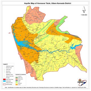
Honnavar Taluk is one of the five coastal taluks in the district of Uttara Kannada in Karnataka, India.

Sagara is a city located in the Indian state of Karnataka. It is also a sub divisional and a taluk headquarters. Located in the Sahyadri Mountain range on the banks of river Varada, it is known for its proximity to Jog Falls and to the historical places of Ikkeri, Keladi and Varadamoola. The river Varada originates near Varada-moola. Sagara subdivision consists of Sagara, Soraba, Hosanagara and Shikaripur taluks.
Talavata is a village in the southern state of Karnataka, India. It is located in the border of Shimoga district and Uttara Kannada District. Its taluk is Sagara, Karnataka.
Sharavathi Wildlife Sanctuary is a protected wildlife sanctuary in the Western Ghats of Karnataka state in India. It is named after the Sharavathi River flowing through the sanctuary. The sanctuary is spread across the forests of Uttara Kannada & Shivamogga districts of Karnataka, Sharavathi Reservoir is present within the sanctuary. The nearest town Sagara is 34 km away and is connected by bus service to Shivamogga, Hubballi, Mangaluru and Bengaluru on a daily basis. The nearest railway station Thalaguppa is 15 Km away, while the nearest airport viz. Mangalore is located about 200 Km from the sanctuary.