This article has multiple issues. Please help improve it or discuss these issues on the talk page . (Learn how and when to remove these template messages)
|
This is a list of waterfalls in India sorted by state. The Indian state of Karnataka has more waterfalls than any other state. Karnataka has 544 waterfalls which are at least 10 meters in height. With a height of 1493 feet, Kunchikal Falls in Shimoga District, Karnataka is the tallest waterfall in the country.
Name | District | Height | Photo | Details |
---|---|---|---|---|
Kailasakona Falls | Chittoor | This perennial waterfall located in the Nagari valley near Tirupati in Chittoor district originates from a fracture in a sheet rock. | ||
Nemaligundla Falls | Prakasam | Near Giddalur town in Nallamala Forest | ||
Ethipothala Falls | Guntur | Situated on Ethipothala river, a tributary of river Krishna, and is located in Thallapalle village of Macherla mandal, Guntur District, Andhra Pradesh | ||
Kapila Theertham | Chittoor | Near holy town Tirumala | ||
Talakona | Chittoor | Highest waterfall in Andhra Pradesh State | ||
Ubbalamdugu Falls | Chittoor | Also called Tada Falls or Kambakam Falls | ||
Katiki Waterfalls | Visakhapatnam | Near Araku, Visakhapatnam District | ||
Thatiguda Falls | ||||
Bhairava Kona | Prakasam | Near Pamur town in Nallamala Forest | ||
Champawati | Prakasam | |||
Shiav Kunda | Prakasam | |||
Basistha | ||||
Penchalakona Water Falls | Nellore | Located around 115 km (71 mi) from Tirupati | ||
Kalyan Revu Water Falls | Chittoor | Located around 10 km (6.2 mi) from Palamaner | ||
Kigal Water Falls | Chittoor | Located around 28 km (17 mi) from Palamaner | ||
Ganganna Sirrasu Water Falls | Chittoor | Located around 10 km (6.2 mi) from Palamaner |
Name | District | Height | Photo | Details |
---|---|---|---|---|
Nuranang Falls | Tawang | 100 m | Also called the Bong Bong Falls, located around 40 km from Tawang. | |
Bap Teng Kang Waterfall | Tawang | 30 m | Also called the BTK Fountain, located about 82 km from Tawang. | |
Chumi Gyatse Falls | Tawang | Located 250 metres from the Chinese controlled side of the Line of Actual Control. It is a collection of 108 waterfalls. | ||
Jung Fall | Tawang | Located 35 km from Tawang and 5 km from Jung. |
Name | District | Height | Photo | Details |
---|---|---|---|---|
Akashiganga Waterfalls | Hojai | 50 km south-east of Nagaon and 26 km from Hojai, near Doboka. | ||
Chapanala | Nagaon | Also known as Champawati Kunda. 28 km east of Nagaon. | ||
Kakochang | Karbi Anglong | Located at a distance of 13 km from Bokakhat, near Kaziranga. | ||
Sivakunda | Morigaon | Situated in the Amsoi hills. | ||
Dikrut (Paklongkam) | East Karbi Anglong | |||
Kangthilangso Waterfall | East Karbi Anglong | Located in Kanthi village, around 12 km from Denarong (Dengaon) along NH 36. | ||
Bheloghat (Paklangso) | East Karbi Anglong | |||
Panimur fall and Koka fall | Dima Hasao District and West Karbi Anglong district | |||
Bendao BaIglai | Dima Hasao | Sampardisa village near Haflong | ||
Tegheria | East Kamrup |
Name | District | Height | Photo | Details |
---|---|---|---|---|
Kakolat Falls | Nawada | 160 ft | ||
North Tank | Jamalpur | |||
Madhuvdhandam | ||||
Dhua Kund Falls | Rohtas | |||
Telhar Kund | Bhabhua | |||
Manjhar Kund | Rohtas | |||
Karkat Waterfall | Kaimur |
Name | District | Height | Photo | Details |
---|---|---|---|---|
Chitrakoot Falls | Jagdalpur | 100 ft (30 m) | ||
Amritdhara falls | Manedragarh | 50 ft (15 m) | ||
Teerathgarh Falls | 300 ft (91 m) | |||
Tree Falls | 300 ft (91 m) |
Name | District | Height | Photo | Details |
---|---|---|---|---|
Arvalem Falls | North Goa | |||
Dudhsagar Falls | South Goa | 310 m (1,020 ft) | ||
Kuske falls | South Goa | |||
Kesarval Falls | South Goa | |||
Tamdi Surla Falls | South Goa |
Name | District | Height | Photo | Details |
---|---|---|---|---|
Juna Ghata Falls | Narmada, Narmada district | |||
Gira falls | near Saputara | |||
Gira dhodh Falls | Dang | near Waghai | ||
Hathni waterfall | Panchmahal | 100 meter | near Jambughoda wildlife sanctuary | |
Jamjir Falls | Junagadh | 12 meter | near Gir Forest National Park | |
Machhu Falls | ||||
Ninai Falls | Narmada, Dediyapada Taluka, Narmada district | |||
Zanzari Falls | Sabarkantha, Dabha, Sabarkantha | |||
Zarwani Falls | Narmada | near Kevadiya, Narmada district | ||
Girmal Falls | Dang, Girmal, Dang District | |||
Jatashankar Falls | Junagadh, Girnar, Junagadh District | |||
Kokam Falls | Dediapada, Narmada District |
Name | District | Height | Photo | Details |
---|---|---|---|---|
Badri Falls | ||||
Bhagsu Falls | Mcleod Gunj area | |||
Jogini Falls | 4 km from Vashisht Temple and 7.5 km from Manali Bus Stand.Location in Manali. | |||
Bundla Falls | 328 ft (100 m) | |||
Chadwick Falls | Shimla region | |||
Machhrial Falls | ||||
Palani Falls | 492 ft (150 m) | |||
Rahla Falls | Leh Manali Highway | |||
Sissu Falls | Leh Manali Highway | |||
Jibhi Waterfall | Jibhi, Tandi |
Name | District | Height | Photo | Details |
---|---|---|---|---|
Chiller Arpid Falls | ||||
Dassam Falls | Ranchi | 144 ft (44 m) | on Kanchi river, a tributary of Subarnarekha river | |
Dharagiri Falls | ||||
Gua Falls | ||||
Halpad Falls | ||||
Hirni Falls | West Singhbhum | |||
Hundru Falls | Ranchi | 320 ft (98 m) | on Subarnarekha river | |
Jadni Falls | ||||
Jonha Falls | also called Gautamdhara | |||
Kelaghagh Falls | ||||
Keridah Falls | ||||
Lodh Falls | 468 ft (143 m) | also called Burhaghagh Falls | ||
Lower Ghaghri Falls | 320 ft (98 m) | |||
Maludah Falls | ||||
Mirchaiya Falls | ||||
Moti Jharna Falls | ||||
Panchghagh Falls | Khunti | |||
Perwa ghagh Falls | ||||
Rajrappa | Ramgarh | |||
Sadni Falls | 200 ft (61 m) | |||
Sita Falls | ||||
Sugabandh Falls | ||||
Upper Ghaghri Falls | ||||
Usri Falls |
Idukki district alone has about 50 small or big waterfalls, most of which are not included above because of not being well known and some being only active during monsoons. It is the same with Wayanad district, Pathanamthitta district and other hilly districts.
Name | District | Height | Photo | Details |
---|---|---|---|---|
Bahuti Falls | Rewa | 650 ft (200 m) | ||
Bhoora Khon Waterfall | ||||
Chachai Falls | Rewa | 427 ft (130 m) | ||
Dhuandhar Falls | Jabalpur | |||
Dugdhdhara Waterfalls | Anuppur | |||
Gangulpara Tank and Waterfall | ||||
Gatha Falls | 300 ft (91 m) | |||
Gorakhaal Fall | ||||
Kapildhara Waterfalls | Anuppur | |||
Keoti Falls | Rewa | 427 ft (130 m) | ||
Kukdi Khapa Waterfall | ||||
Lilahi Waterfall | ||||
Pandav Falls | ||||
Patalpani waterfall | Indore | 200 ft (61 m) | ||
Pawa Waterfalls | ||||
Purwa Falls | 230 ft (70 m) | |||
Rajat Prapat | 350 ft (110 m) | |||
Raneh Falls | ||||
Sanakua Waterfalls | ||||
Shambhudhara Waterfalls | ||||
Sultan Garh Waterfall | ||||
Tincha Falls |
Name | District | Height | Photo | Details |
---|---|---|---|---|
Ale's Waterfall | Satara | 8–9 km from Mahabaleshwar | ||
Amboli Ghat Falls | Sindhudurg | 400 ft (120 m) | 1 km from Amboli; well known for its fresh and pleasing environs | |
Barki Waterfalls | Kolhapur | 65 km (40 mi) from Kolhapur | ||
Berki Waterfalls | Kolhapur | 4 km (2.5 mi) from Gaganbawada or 75 km (47 mi) from Kolhapur, in Amboli Ghats | ||
Bhilar Waterfalls | Satara | Seen on the Mahabaleshwar Panchgani road is one of the beautiful falls on the Kudali river arising from the Bhilar village | ||
Bhildari Valley Waterfalls | Aurangabad | Near 3 km (1.9 mi) from Kannad or 12 km (7.5 mi) from Chalisgaon | ||
Bhivpuri Waterfalls | Thane | 8 km (5.0 mi) from Bhivpuri railway station, or 20 km (12 mi) from Karjat railway station | ||
Chinchghar Falls | Sindhudurg | 10 km (6.2 mi) from Kudal town | ||
Chinchoti Waterfalls | Thane | 100 ft (30 m) high & 20 ft (6.1 m) broad | 5 km (3.1 mi) from Mumbai-Palghar highway near Vasai | |
Chinmans waterfalls | Satara | It is 2.5 km (1.6 mi) away from Mahabaleshwar, towards the south into the Koyana Valley | ||
Chirkehind Waterfalls | Satara | In the lower portion of the Ambenali ghat about 6–7 km (3.7–4.3 mi) after the diversion to Ragtag | ||
Dabhosa Waterfalls | Thane | 300 ft (91 m) | 5 km (3.1 mi) from Javhar | |
Dhobi Falls | Satara | 450 ft (140 m) | 3 km (1.9 mi) from Mahableshwar town, formed on the banks of Koyna River | |
Dodhvne Tivre Falls | Ratnagiri | 200 ft (61 m) | 10 km (6.2 mi) from Sangameshwar | |
Dudhsagar Waterfalls | Nashik | 100 ft (30 m) | Located around 8 km (5.0 mi) to the west of Nasik near Someshwar Temple | |
Dugarwadi Waterfalls | Nashik | 450 ft (140 m) | Approx. 30 km from Nashik, Near Nashik | |
Garambi Waterfalls | Raigad | 100 ft (30 m) | Located near Murud, 5 km (3.1 mi) from Janjira | |
Gavlideo Hill Falls | Thane | 5 km (3.1 mi) from Thane, located near Thane - Belapur road | ||
Kandhar Waterfalls | Sangli | 25 km (16 mi) from Peth Naka on NH4, 65 km (40 mi) from Sangli, 70 km (43 mi) from Miraj railway junction | ||
Kataldhar Lonavla | Pune | 350 ft (107 m) | 11 km from Lonavala | |
Kelghar Waterfalls | Satara | on the Mahabaleshwar-Medha-Satara road almost 14 to 15 kilometers away from the main marketplace | ||
Kune Falls | Pune | 659 ft (201 m) | 10 km (6.2 mi) from old Mumbai-Pune Expressway in Lonvala-Khandala valley | |
Lingamala Waterfalls | Satara | 620 ft (190 m) | Located 6 km (3.7 mi) away from the famous hill station Mahabaleshwar and at top of the Venna Valley | |
Malsej Ghat Falls | Thane | 400 ft (120 m) | 45 km (28 mi) from Murbadtown, in the Malsej ghat falls or 115 km (71 mi) from Thane City | |
Mandakini Waterfalls | Satara | 25 km (16 mi) from Mahableshwar | ||
Marleshwar Waterfalls | Ratnagiri | 5 km (3.1 mi) from Devrukh, formed on the banks of Bav River | ||
Nagartas Falls | Sindhudurg | 320 ft (98 m) | 50 km (31 mi) from Kankavli town, in the Amboli Ghat or 100 km (62 mi) from Kolhapur | |
Napne Falls | Sindhudurg | 250 ft (76 m) | 15 km (9.3 mi) from Vaibhavwadi | |
Needle Point Waterfalls | Satara | 20 km (12 mi) from Panchgani, close to Mahabaleshwar-Panchgani route | ||
Nivali Falls | Ratnagiri | 50 km (31 mi) from Sangameshwar, located on Ratnagiri-Ganpatipule route | ||
Ozarde Waterfalls | Patan, Satar | 10 km (6.2 mi) from Koyna | ||
Palsambe Waterfalls | Kolhapur | 45 km (28 mi) from Kolhapur, on the way to Gaganbawada at Palsamba | ||
Pandavkada Falls | Raigad | 350 ft (110 m) | Situated in the hills near Kharghar, Navi Mumbai near Mumbai-Pune Expressway | |
Peb Waterfalls | Raigad | 10 km (6.2 mi) from Neral railway station, on the way to Matheran | ||
Ramatirth Waterfall | Kolhapur | On the banks of Hiranyakeshi river nearly 10 km (6.2 mi) from Ajara | ||
Ramdharneshwar Waterfalls | Raigad | 20 km (12 mi) from Alibaug, near Khim village | ||
Rajmachi Waterfalls | Pune | 5 km (3.1 mi) from Khandala, can be seen from Mumbai - Pune Expressway | ||
Randha Falls | Ahmednagar | 350 ft (110 m) | 50 km (31 mi) from Nashik, or 45 km (28 mi) from Kasara railway station | |
Sahastrakunda Waterfalls | Nanded | situated on Painganga river at sahastrakund | ||
SavDav Waterfalls | Sindhudurg | 10 km (6.2 mi) from Kankavli town | ||
Sawatkada Waterfalls | Raigad | On the way to Garambi, through the village Shighre, near Alibaug | ||
Sawatkada Waterfalls | Ratnagiri | 1 km from Chiplun city Chiplun city | ||
Tamhini Waterfalls | Pune | In the Tamihini ghats, near Pune | ||
Tapalwadi Falls | Thane | 350 ft (110 m) | 3 km (1.9 mi) from Neral railway station on the route to Matheran hill station | |
Thoseghar Waterfalls | Satara | 1,150 ft (350 m) | 36 km (22 mi) from Satara, a full front view of the falls can be obtained by going to Chalkewadi and then walking down the road for 5 km (3.1 mi) | |
Tiger Falls | Pune | near Lonavala in Khandala Ghat, 80 km (50 mi) from Mumbai, or 70 km (43 mi) from Pune | ||
Tigher Waterfalls | Thane | 300 ft (91 m) | 10 km (6.2 mi) from Karjat railway station | |
Umbrella Falls | Ahmednagar | 50 km (31 mi) from Nashik, or 45 km (28 mi) from Kasara railway station | ||
Usarvardhane Waterfalls | Thane | 300 ft (91 m) | Near the Kansai village, 5 km (3.1 mi) by vehicle and a 45-minute trek thereafter | |
Vajrai Waterfall | Satara | 853 ft (260 m) | 27 km (17 mi) from Satara District near Kas flower valley | |
Vihigaon Waterfalls | Mumbai | 125 km (78 mi) | 125 km (78 mi) from Mumbai city near Kasara, on Mumbai-Nashik Highway map [3] | |
Vyaghreshwar Waterfall | Sindhudurg | 300 ft (91 m) | near Mnche, 30 km (19 mi) from Tarale (which is on Mumbai-Goa highway) | |
Zenith Waterfalls | Thane | 450 ft (140 m) | 10 km (6.2 mi) from Khopoli railway station, 20 km (12 mi) from Karjat railway station |
Name | District | Height | Photo | Details |
---|---|---|---|---|
Barak Falls | Tamenglong | |||
Khayang Falls [4] | Ukhrul | |||
Sadu Chiru Waterfalls [5] | Kangpokpi | Popularly known as Leimaram Falls, Sadar Hills | ||
Taphou Falls | Kangpokpi | A series of three waterfalls located near Taphou Kuki Village in Manipur | ||
Khoupum Waterfalls [6] | Tamenglong | |||
Ngaloi Waterfalls | Churachandpur |
Name | District | Height | Photo | Details |
---|---|---|---|---|
Tuirihiau Falls | ||||
Vantawng Falls | 324 ft (99 m) | |||
Badaghagara | Kendujhar | |||
Kandhadhar Falls | ||||
Sanaghagara Falls | Kendujhar |
Name | District | Height | Photo | Details |
---|---|---|---|---|
Menal Falls | Chittorgarh | 153 ft | 22 km from Begun | |
Bhemlat Falls | Bundi | 50 ft | Bundi | |
Alewa Falls | Alwas | |||
Chuliya fall | chittorgarh | 9 m (30 ft) | Rawatbhata, Chittorgarh |
Name | District | Height | Photo | Details |
---|---|---|---|---|
Kuntala Waterfall | Adilabad | 45 m (148 ft) | This waterfall is the highest waterfall in Telangana State. | |
Pochera Falls | Adilabad | 20 m (66 ft) | Situated about 35 km (22 mi) from Nirmal, on National Highway no.7, and is on the way to Adilabad. [7] | |
Mallela Theertham Falls | Mahabubnagar | It is located around 58 km (36 mi) from Srisailam, Andhra Pradesh . | ||
Bogatha Waterfall | Jayashankar Bhupalpally | It is located in Koyaveerapuram G, Wazeedu Mandal, 120 km from Bhadrachalam. | ||
Gayatri Waterfalls | Adilabad | It is located near Nirmal | ||
Paarakaphi Waterfalls | Adilabad | It is located near Utnoor | ||
Savatula Gundam Waterfalls | Adilabad | 30 km from Asifabad | ||
Sirnapally Waterfalls | Nizamabad | 20 km from Nizamabad |
Name | District | Height | Photo | Details |
---|---|---|---|---|
Lakhaniya Dari Waterfall | Mirzapur | 150 metres (490 ft) | 30 km from Chunar [8] | |
Sirsi Waterfall | Mirzapur | It's located on the Sirsi River, about 45 km from Mirzapur and 60 km from Vindhyachal | ||
Tanda Waterfall | Mirzapur | 30 feet (9 meters) | A scenic waterfall and picnic spot located about 14 km south of Mirzapur. It's surrounded by a water reservoir and natural flora and fauna, and is easily accessible by road. [9] | |
Sidhnath Ki Dari Waterfall | Mirzapur | 100 feet | It's located in the Mirzapur district, about 14–20 kilometers from Chunar and 30 kilometers from Varanasi. | |
Vindham Waterfall | Mirzapur | 58 meters (190 feet) | It's located about 2 kilometers from the BHU South Campus | |
Devdari Waterfalls | Chandauli | 58 meters (190 feet) | located in the Chandraprabha Wildlife Sanctuary in Chandauli, Uttar Pradesh, India, about 65 kilometers from Varanasi | |
Rajdari Waterfall | Chandauli | 65 meters | located in the Chandraprabha Wildlife Sanctuary in Chandauli, Uttar Pradesh, India, about 65 kilometers from Varanasi | |
Mukha Waterfalls | Sonbhadra | 100 feet | situated on Robertsganj-Ghorawal-Mukha Dari road approximately 55 km in the west of Robertsganj [10] | |
Shabari Waterfalls | Chitrakoot | 100 feet | located at the beginning of the Mandakini River, near the town of Jamunihai, and about 8 kilometers south of Markundi town in Chitrakoot [11] | |
Chuna Dari Waterfall | Mirzapur | 50 meters(165 feet) | It's located in Jangal Mahal, Chunar, Mirzapur District, |
Name | District | Height | Photo | Details |
---|---|---|---|---|
Birthi Falls | 410 ft (120 m) | |||
Corbett Falls | 18 ft (5.5 m) | |||
Gauri Kund | ||||
Kempty Falls | Mussoorie | 40 ft (12 m) | ||
Pushpawati Falls | ||||
Surya Kund | ||||
Tapta Kund | ||||
Tiger Falls | 312 ft (95 m) | |||
Vasudhara Falls | 400 ft (120 m) | |||
Neer Garh Falls | Rishikesh |
Tourism in India is 4.6% of the country's gross domestic product (GDP). Unlike other sectors, tourism is not a priority sector for the Government of India. Forbes magazine ranked India as the 7th most beautiful country in 'The 50 Most Beautiful Countries In The World' rankings. The World Travel and Tourism Council calculated that tourism generated ₹13.2 lakh crore (US$170 billion) or 5.8% of India's GDP and supported 32.1 million jobs in 2021. Even though, these numbers were lower than the pre-pandemic figures; the country's economy witnessed a significant growth in 2021 after the massive downturn during 2020. The sector is predicted to grow at an annual rate of 7.8% to ₹33.8 lakh crore (US$420 billion) by 2031. India has established itself as the 5th largest global travel healthcare destination with an estimated market size of around $9 billion in 2019, out of the total global travel healthcare industry of $44.8 billion(2019). In 2014, 184,298 foreign patients travelled to India to seek medical treatment.
Kodagu district is an administrative district in the Karnataka state of India. Before 1956, it was an administratively separate Coorg State, at which point it was merged into an enlarged Mysore State.
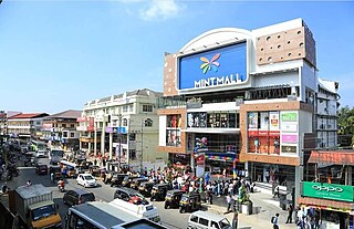
Sultan Bathery is a town and municipality in the Wayanad district of Kerala, India, near its borders with Tamil Nadu and Karnataka. Once known as a strategic location in the Malabar region, Sultan Bathery is the headquarters of the Sultan Bathery taluk.
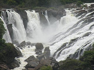
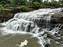
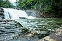
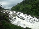
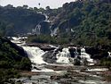
Shivanasamudra Falls is a cluster of waterfalls on the borders of Malavalli, Mandya and Kollegala, Chamarajanagara, in Karnataka, India, situated along the river Kaveri. The falls form the contour between the districts of Chamarajanagara and Mandya. The Bharachukki Falls in Kollegala, with a height of 69 metres, and the Gaganachukki Falls in Malavalli, with a height of 90 metres, collectively form the Shivanasamudra Falls.
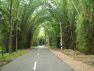
Ghat Roads are access routes into the mountainous Western and Eastern Ghats, mountain ranges of the Indian subcontinent. These roads are remarkable feats of engineering, and most were constructed during the British Raj. Ghat Roads were built to connect to the hill stations established in the mountains for residents to avoid summer heat. They generally served to connect coastal areas with the upper Deccan Plateau.
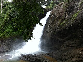
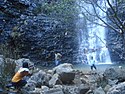
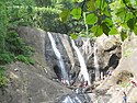
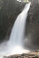
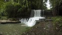
Soochipara Falls also known as Sentinel Rock Waterfalls is a three-tiered waterfall in Vellarimala, Wayanad, India. It is surrounded by deciduous, evergreen and montane forests. Locally referred to as Soochipara, the 15-20 minute drive from Meppadi to Sentinel Rock Waterfalls has views of a number of Wayanad's tea estates. The Sentinel Rock Waterfalls is 200 metres (656 feet) and offers a cliff face that is used for rock climbing. The water from Soochipara Falls later joins Chulika River or popularly known as Chaliyar River after Velarimala Hills near Cherambadi in Kerala.
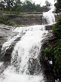
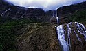
Meenmutty Falls is located 29 km from Kalpetta in Wayanad District in the state of Kerala, India. It is a three-tiered waterfall with a height of 300 metres. Meenmutty is a combination of Malayalam words Meen (fish) and Mutty (blocked). It can be accessed from Mananthavady - Kuttiady road . Meenmutty waterfalls are dangerous during rainy seasons due to high inflow and many people have drowned since 1991. Meenmutty falls is surrounded by Lush green tea plantations making the hike to the falls a memorable experience to the tourists.
Meenmutty Falls is a waterfall located 45 kilometres (28 mi) from Trivandrum city in Thiruvananthapuram District in the Indian state of Kerala, India. The falls are located near the Ponmudi hill station, Thiruvananthapuram district and Agastya Mala Biosphere reserves. This waterfalls is situated along the upper riparian course of Vamanapuram River.
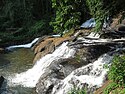
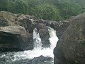
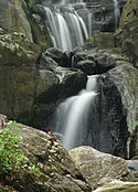
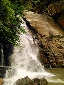
The Irupu Falls are located in the Brahmagiri Range in the Kodagu district of Karnataka, India, bordering the Wayanad district of Kerala. It is a fresh water cascade and is situated at a distance of 48 km from Virajpet on the highway to Nagarhole. The falls are also known as the Lakshmana Tirtha Falls, derived from the name of the tributary of Cauvery which starts from these falls, the Lakshmana Tirtha River.
The Geography of South India comprises the diverse topological and climatic patterns of South India. South India is a peninsula in the shape of a vast inverted triangle, bounded on the west by the Arabian Sea, on the east by the Bay of Bengal and on the north by the Vindhya and Satpura ranges.
The National Bravery Awards are a set of awards given annually to about 25 Indian children below 18 years of age for "meritorious acts of bravery against all odds." The awards are given by the Government of India and the Indian Council for Child Welfare (ICCW). The award was instituted in 1957.
Babu Varghese helped to make the South Indian state of Kerala, and in particular the image of houseboats on the Kerala backwaters, a notable tourist destination.
United Nurses Association (UNA) is a professional association of registered nurses in India. It was started in Kerala. The organisation discusses problems faced by nurses in their working environment.
Charpa Falls is a waterfall located in Athirappilly panchayath in Thrissur district of Kerala. Located on the west-flowing Chalakudy River, this waterfall lies in between the more famous Athirappilly Falls and Vazhachal Falls. It is a popular stopover for tourists who are visiting the Athirappilly and Vazhachal Falls. It is located close to the road, and during monsoon months, the water splashes onto the road. During the dry season, the water stops flowing.
This article gives a list of the territories of the dioceses of the Catholic Church in India.
Meppadi is a village in the Indian state of Kerala. It is an extremely scenic hill station on the State Highway between Kozhikode and Ooty. The nearest city is Kalpetta, which is the headquarters of the Wayanad revenue district.
Northeast India consists of eight states: Arunachal Pradesh, Assam, Manipur, Meghalaya, Mizoram, Nagaland, Sikkim and Tripura. Tourism in this area is based around the unique Himalayan landscape and culture distinct from the rest of India.
Mukkha Fall is situated on the Robertsganj to Ghorawal road, approximately 50 kilometres (31 mi) to the west of Robertsganj and 15 kilometres (9.3 mi) from Ghorawal, in the Sonbhadra district of Uttar Pradesh on the Belan River. It is a waterfall in Uttar Pradesh.
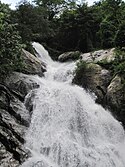
The Wayanad District of Kerala, India has a wide variety of tourist attractions ranging from religious sites to natural, and historical sites. This district is divided into three towns, Kalpetta, Sultan Bathery and Mananthavady. All Major Tourism destinations in the district are maintained by the District Tourism Promotion Council.
Tourism in India is economically important and ever-growing. The World Travel & Tourism Council calculated that tourism generated ₹14.02 lakh crore (US$180 billion) or 9.6% of the nation's GDP in 2016 and supported 40.343 million jobs, 9.3% of its total employment. The sector is predicted to grow at an annual rate of 6.8% to ₹28.49 lakh crore (US$360 billion) by 2027.