Nuapada district

Last updated

Nuapada district
Yogeswar Temple, Patora.JPG
Khariar street.jpg
Top: Yogeswar Temple, Patora
Bottom: Street in Khariar
India Odisha Nuapada district.svg
Location in Odisha
Coordinates: 20°39′00″N82°49′59″E / 20.65°N 82.833°E / 20.65; 82.833
CountryFlag of India.svg  India
State Orissa Flag(INDIA).png Odisha
Established27 March 1993
Headquarters Nuapada
Government
   Collector & District Magistrate Hemakanta Sahay, IAS
  Divisional Forest Officer Cum Wildlife WardenKhushwant Singh, IFS
   Superintendent of Police Gundala Reddy Raghavendra IPS
Area
  Total3,408 km2 (1,316 sq mi)
Population
 (2011) [1]
  Total610,382
  Density157/km2 (410/sq mi)
Languages
  Official Odia, English
Time zone UTC+5:30 (IST)
PIN
766105
Vehicle registration OD-26
Sex ratio 1020 /
Literacy58.20%
Lok Sabha constituency Kalahandi
Vidhan Sabha constituency2
 
Climate Aw (Köppen)
Precipitation 1,230 millimetres (48 in)
Website www.nuapada.nic.in

Nuapada district is an area of Odisha state in India. Nuapada town is the headquarters of the district. It has one subdivision: Nuapada, and five blocks: Khariar, Sinapali, Boden, Komna, and Nuapada. Nuapada District has three Notified Area Councils: Khariar, Khariar Road, and Nuapada, six tehsils and more villages such as Gandabahali, Tukla, Hatibandha, Duajher, Bargaon, Tarbod, Udyanbandh, and Larka.

Contents

Major cities, towns, and villages

Amar Khariar Amar Khariar.png
Amar Khariar
Shiv Temple, Gandabahali Shiv Temple Gandabahali Entry Gate.jpg
Shiv Temple, Gandabahali

History

The district of Nuapada was a part of Kalahandi district until early March 1993, but for administrative convenience, Kalahandi District was divided into two parts — Kalahandi and Nuapada vide State Government Notification No. DRC-44/93/14218/R dated 27 March 1993. Nuapada District now comprises one sub-division Nuapada, six tehsils (Nuapada, Komana, Khariar, Sinapalli, Boden and jonk) and five community development blocks (Khariar, Sinapalli, Boden, Nuapada and Komna).It is believed that the District of Kalahandi formed in ancient time a part of Mahakantara territory. During 4th century CE, when Samudra Gupta led his campaign through this region a king named Vyaghraraja was ruling over Mahakantara. After Vyaghraraja, the Nala kings like Bhavadatta Varman, Arthapati and Skanda Varman ruled over this region up to about 500 CE.

In the 6th century CE a new kingdom developed in the Kalahandi tract under King Tustikara, but very little is known about other kings of his family.The Nuapada area was by that time under the kings of Sarabhapuriya dynasty whose copper plate record and gold coins are available. This region came under the occupation of the Somavamsis of South Kosala during the 8th century CE when Mahaivagupta Balarjuna was ruling from his headquarters at Sripur.

In the 9th century CE when the Somavamsis were ousted from the Sripur region and organized a new kingdom in Sonepur-Sambalpur tract, the Kalahandi portion continued to be under their rule. In fact, Mahabhabagupta Janamejaya occupied the Trikalinga territory (Koraput area) through Kalahandi. In the middle of the 10th century CE the Somavamsi dominion embraced the whole of Orissa under Yayati II Mahasivagupta. His son Udyotakesari divided this dominion and placed the western part (Kosala) under the rule of a collateral branch. Kalahandi was included in the Kosala kingdom the capital of which was Jajatinagar near Sonepur.

The rule of the Somavamsis in Kosala collapsed by the invasion of Rajendra Chola in 1022 CE and after that the territory came under the rule of the Telugu Cholas. In 1038 CE Vajrahasta V of Eastern Ganga dynasty became powerful in Parlakhemundi region and after the death of Rajendra Chola in 1044 CE he assumed independence and occupied the hilly territory including Koraput and Kalahandi.

The Gangas ruled over Kalahandi for a long period. The stone inscription at Narla reveals that one Madanamahadeva was ruling over Kamalmandala in 1231 CE apparently as a feudatory of the Gangas. Tradition preserved by the Durbar of Kalahandi reveals that the Nagas commenced their rule in Kalahandi from Vikram sambat 1062 or CE 1005. If the tradition is to be believed it may be said that the Nagas ruled over Kamalmandala as feudatories of the Gangas till 14th century CE after which they owed allegiance to the Suryavamshi Gajapatis.

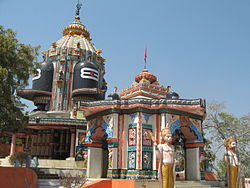
It is not known when Kamalmandala became known as Kalahandi. The earliest reference to the name Kalahandi is found in the Dadhivaman temple inscription dated in Yugabda 4819, i.e., CE 1718. In British records this territory was called Karond. This territory assumed independence after the downfall of the Gajapatis of Orissa in 1568 CE According to tradition the Kalahandi kingdom commanded sovereign power over eighteen garhs before it was occupied by the Bhonsles of Nagpur in the middle of the 18th century CE In 1803 when the Marathas were defeated by the British and the coastal regions of Orissa as well as the Patna-Sambalpur group of states came under the British, Kalahandi, very probably, continued under the Marathas. The Patna-Sambalpur group was subsequently restored to Raghujee Bhonsla II in 1806. The Marathas of Nagpur became subordinate to British power after the Third Anglo-Maratha War in 1818. But Kalahandi continued to be under Maratha rule till 1853, when the Nagpur state lapsed to the British Crown as Raghuji III died without an heir. The Chauhans were ruling over Khariar since about the time of Rama Deo, the first Chauhan king of Patna. In 1590 CE Gopal Ray, a scion of the Patna family became the king of Khariar and started a line of semi-independent kings in that territory. Khariar came under the Marathas in 1741 CE and the British occupied it in 1818. In 1905 when the District of Sambalpur and some feudatory states including Kalahandi were amalgamated with Orissa Division of Bengal, the Government of the Central Provinces opposed merger of Khariar with Sambalpur and in 1906 Khariar became a part of the Mahasamund tehsil. When the separate province of Orissa was formed in 1936, Khariar was added to Orissa and was made a sub-division (Nuapada sub-division) of Sambalpur District. On the 1st January 1948, Kalahandi along with other feudatory states of Orissa except Mayurbhanj, merged with Orissa and on that date the new District of Kalahandi was formed with the ex-states of Kalahandi, Patna and Sonepur. On the 1st November 1949, Patna and Sonepur together constituted a separate District and the Nuapada sub-division of Sambalpur was added to the District of Kalahandi.

Geography

Nuapada district is in the western part of Odisha, lying between latitude 20° 0' N and 21° 5' and between longitude 82° 20' E and 82° 40' E. Its boundaries extend in the north, west and south to Mahasamund district in Chhattisgarh and in the east to Bargarh, Balangir and Kalahandi districts. The district has an area of 3407.5 km² and the administrative headquarters is located at Nuapada.

The plains of Nuapada subdivision are fringed by rugged hill ranges stretching southward, which belong to the main line of the Eastern Ghats and contain extensive plateaus of about 4000 ft (1200 m) in elevation.

Economy

Due to the conspicuous absence of any industry, the economy revolves around agricultural activities. Three major irrigation projects — the Upper Jonk, the Sunder dam, and the upcoming Lower Indira Irrigation Project — provide support to 45,000 acres of land. Rice is the main crop in the entire district. Other crops like corn (maize), cotton, and onion make up a major share of crops under cultivation. More than 10,000 households migrate to other states in search of better employment opportunities every year after the harvesting season is over. Though the district is tops in MGNREGS implementation, the advance provided by labor contractors before Nuakhai festival lure ignorant laborers into the plot. Due to unregistered and uninformed migration, protection of migrant laborers has become a challenge to the government. In 2006, the Ministry of Panchayati Raj named Nuapada one of the country's 250 most backward districts (out of a total of 640). [2] it is one of the 19 districts in Odisha currently receiving funds from the Backward Regions Grant Fund Programme (BRGF). [2]

Demographics

Historical population
YearPop.±% p.a.
1901122,559    
1911147,489+1.87%
1921150,180+0.18%
1931178,787+1.76%
1941203,379+1.30%
1951219,850+0.78%
1961267,272+1.97%
1971338,894+2.40%
1981392,683+1.48%
1991469,482+1.80%
2001530,690+1.23%
2011610,382+1.41%
source: [3]
Religions in Nuapada district (2011) [4]
ReligionPercent
Hinduism
98.48%
Islam
0.81%
Other or not stated
0.71%

In the 2011 Indian census, Nuapada district had a population of 610,382. [1] roughly equal to the nation of Solomon Islands [5] or the US state of Wyoming. [6] This gives it a ranking of 524th in India (out of a total of 640). [1] The district has a population density of 157 inhabitants per square kilometre (410/sq mi). [1] Its population growth rate over the decade 2001–2011 was 14.28%. [1] Nuapada has a sex ratio of 1020 females for every 1000 males, [1] and a literacy rate of 58.2%. 4.99% of the population lives in urban areas. Scheduled Castes and Scheduled Tribes make up 13.46% and 33.80% of the population respectively. [1]

Languages of Nuapada district (2011) [7]

   Odia (58.02%)
   Sambalpuri (23.72%)
   Chhattisgarhi (15.04%)
   Hindi (1.68%)
  Others (1.54%)

At the time of the 2011 census, 58.02% of the population in the district spoke Odia, 23.72% Sambalpuri, 15.04% Chhattisgarhi and 1.68% Hindi as their first language. [7]

Politics

Vidhan Sabha constituencies

Nuapada district is part of Kalahandi Lok Sabha constituency. The MP of Kalahandi is Basanta Kumar Panda from the BJP.

The following are the two Vidhan Sabha constituencies [8] [9] of Nuapada district and the elected members [10] of that area.

No.ConstituencyReservationExtent of the Assembly Constituency (Blocks)Member of 14th Assembly Party
71 Nuapada NoneNuapada, Komna, Khariar Road (NAC)Rajendra Dholkia BJD
72 Khariar NoneBoden, Sinapalli, Khariar, Khariar (NAC)Adhiraj Panigrahi INC

Related Research Articles

<span class="mw-page-title-main">Sambalpur district</span> District of Odisha in India

Sambalpur District is a district in the western part of state of Odisha, India. The historic city of Sambalpur is the district headquarters.

<span class="mw-page-title-main">Balangir district</span> District of Odisha in India

Balangir District, also called Bolangir District, is a district situated in Odisha state of India. The district has an area of 6,575 km2 (2,539 sq mi), and a population of 1,648,997. The town of Balangir is the district headquarters. The composition of the land is predominantly rural. Other important big & small towns in Balangir district are Titlagarh, Patnagarh, Kantabanji, Loisingha, Saintala, Belpada, Tushra, Agalpur, Deogaon, Chudapali, Biripali, Bhalumunda, Bangomunda, Sindhekela, Turekela and Muribahal.

<span class="mw-page-title-main">Kalahandi district</span> District of Odisha in India

Kalahandi district is a district of Odisha in India. Archaeological evidence of Stone Age and Iron Age human settlement has been recovered from the region. Asurgarh offered an advanced, well civilised, cultured and urban human settlement about 2000 years ago in the region. In South Asia it is believed that the lands of Kalahandi district and Koraput district were the ancient places where people started cultivation of paddy. In ancient time it was known as Mahakantara and Karunda Mandal, which means treasure of precious stones like karandam (corundum/manik), garnet, beruz, neelam, and alexandrite, etc. Manikeswari is the clan deity of Kalahandi may also signify its historical name.

<span class="mw-page-title-main">Bargarh district</span> District of Odisha in India

Bargarh District is an administrative district of Odisha state in eastern India. The city of Bargarh is its district headquarters. The district was carved out of the erstwhile district of Sambalpur on 1 April 1993.

<span class="mw-page-title-main">Boudh district</span> District of Odisha in India

Boudh District is an administrative and a municipal district, one of the thirty in the Odisha, India. The district headquarters of the Boudh District is the city of Boudh.

Nuapada is a town in western region of Odisha state of eastern India. It is the headquarter of Nuapada district. Nuapada district was carved out of the undivided Kalahandi district on 27 March 1993. It is on the western border of Odisha with Chhattisgarh. The district is part of Odisha both linguistically and culturally. It is one of the most underdeveloped districts of Odisha and India as well.

Sambalpur is the fifth largest city in the Indian State of Odisha. It is located on the banks of river Mahanadi, with a population of 335,761. Prehistoric settlements have been recorded there. It is the home of the Sambalpuri sari.

<span class="mw-page-title-main">Orissa Tributary States</span> Group of princely states in Odisha, India

The Orissa Tributary States, also known as the Garhjats and as the Orissa Feudatory States, were a group of princely states of British India now part of the present-day Indian state of Odisha.

<span class="mw-page-title-main">Khariar</span> City in Odisha, India

Khariar is a city and a Notified Area Council in Nuapada District of the Indian state of Odisha.

<span class="mw-page-title-main">Eastern Ganga dynasty</span> Medieval era Indian royal Hindu dynasty

The Eastern Ganga dynasty were a large medieval era Indian royal Hindu dynasty that reigned from Kalinga from as early as the 5th century to the mid 20th century. Eastern Gangas ruled much of the modern region of Odisha in three different phases by the passage of time, known as Early Eastern Gangas (493–1077), Imperial Eastern Gangas (1077–1436) and Khemundi Gangas (1436–1947). They are known as "Eastern Gangas" to distinguish them from the Western Gangas who ruled over Karnataka. The territory ruled by the dynasty consisted of the whole of the modern-day Indian state of Odisha, as well as major parts of north Andhra Pradesh, parts of Chhattisgarh and some southern districts of West Bengal. Odia language got official status in their regime following the evolution of the language from Odra Prakrit. The early rulers of the dynasty ruled from Dantapuram; the capital was later moved to Kalinganagara, and ultimately to Kataka and then to Paralakhemundi.

<span class="mw-page-title-main">Patna State</span> Princely state of India

Patna State was a princely state in the Eastern States Agency of India during the British Raj. It had its capital at Balangir. Its area was 6,503 km2 (2,511 sq mi).

<span class="mw-page-title-main">Sambalpuri language</span> Indo-Aryan language spoken in western Odisha, India

Sambalpuri is an Indo-Aryan language variety spoken in western Odisha, India. It is alternatively known as Western Odia, and as Kosali, a recently popularised but controversial term, which draws on an association with the historical region of Dakshina Kosala, whose territories also included the present-day Sambalpur region.

The history of Kalahandi goes back to the primitive period where a well-civilized, urbanized, and cultured people inhabited this land mass around 2000 years ago. The world's largest celt of Stone Age and the largest cemetery of the megalithic age have been discovered in Kalahandi. This shows the region had a civilized culture since the pre-historic era. Asurgarh near Narla in Kalahandi was one of the oldest metropolises in Odisha whereas the other one was Sisupalgarh near Bhubaneswar. Some other historical forts in the region includes Budhigarh, Amthagarh, Belkhandi and Dadpur-Jajjaldeypur. This land was unconquered by the great Ashoka, who fought the great Kalinga War, as per Ashokan record. In medieval period the region had played a prominent role to link South India, Eastern India and Central India region and witnessed the battle ground for Somavamsi, Chola, Kalachuris of Kalyani and Eastern Ganga dynasty. Kalahandi region was the main route for Chola to attack Subarnapur.

Bhawanipatna is classified as one of the major tourist destinations by the tourism Department of Government of Odisha. All the tourist attraction in Kalahandi region comes under Bhawanipatna jurisdiction. Though tourist potential of Kalahandi has not been exploited optimally due to poor marketing, political negligence and infrastructure development, the land is very rich in terms of water fall, forest and wild life, natural and scenic beauty, tribal life, mountains, agriculture field, historical sites and handicrafts. The best time to visit Kalahandi region is from October to March. April–June is hard Summer and the mercury may rise to 45 degree C and June to August is the Monsoon Season. It occasionally rains in September, but do not miss the great festival like Nuakhai in September and Dassara in end of September or early October. Beginning of Dessara marks the pleasant weather condition till the celebration of Chaitra in February/March.

Sonepur, is the district headquarters of Subarnapur district of Odisha, has a special place on the political and cultural map of India since the pre-historic period. It is bounded on the north by Sambalpur district, on the south and the South-East by Boudh district, on the east by Rairakhol sub-division of Sambalpur district and on the west by the ex-state Patna.

Khariar is a Vidhan Sabha constituency of Nuapada district, Odisha.

Boden is one of the five blocks in the Nuapada District in the Indian state of Odisha. The five blocks are Khariar, Nuapada, Komna, Boden and Sinapali. The main town is Boden, 27 kilometres from Khariar, and 97 kilometres from Nuapada district headquarters. Fourteen Gram Panchayats and eighty-nine Revenue Villages make up in Boden block.

<span class="mw-page-title-main">Chindaka Naga</span>

The Chindaka Nagas were a dynasty that ruled over parts of modern-day Odisha and Chhattisgarh. Their kingdom was known as Chakrakota mandala and included the present-day districts of Bastar, Koraput and Kalahandi. They were constantly at war with their neighbours- the Somavamshi dynasty, the Kalachuris of Ratnapura, the Mana dynasty and the Western Chalukya Empire.

<span class="mw-page-title-main">Gandabahali</span> Village/Town in Odisha, India

Gandabahali is a village in Sinapali Block in the south of Nuapada District in Odisha, India.

References

  1. 1 2 3 4 5 6 7 "District Census Handbook 2011 - Nuapada" (PDF). Census of India . Registrar General and Census Commissioner of India.
  2. 1 2 Ministry of Panchayati Raj (8 September 2009). "A Note on the Backward Regions Grant Fund Programme" (PDF). National Institute of Rural Development. Archived from the original (PDF) on 5 April 2012. Retrieved 27 September 2011.
  3. Decadal Variation In Population Since 1901
  4. "Table C-01 Population by Religious Community: Odisha". Census of India, 2011. Registrar General and Census Commissioner of India.
  5. US Directorate of Intelligence. "Country Comparison:Population". Archived from the original on 13 June 2007. Retrieved 1 October 2011. Solomon Islands 571,890 July 2011 est.
  6. "2010 Resident Population Data". U. S. Census Bureau. Retrieved 30 September 2011. Wyoming 563,626
  7. 1 2 "Table C-16 Population by Mother Tongue: Odisha". Census of India 2011. Registrar General and Census Commissioner of India.
  8. Assembly Constituencies and their EXtent
  9. Seats of Odisha
  10. "List of Member in Fourteenth Assembly". ws.ori.nic.in. Archived from the original on 2 May 2007. Retrieved 19 February 2013. MEMBER NAME