The region of Khariar was under the rule of the Chauhan dynasty of Patna State which was established by Ramai Deva of the Chauhan dynasty in the 14th century CE who were vassals of the Eastern Ganga dynasty which was declining following invasions from the northern part of the Indian subcontinent.[1][2] The Chauhan reign from Patnagarh continued over the region and later expanded through the establishment of their cadet branches extending their rule over areas of Western Odisha and eastern Chhattisgarh.[3] In 1600 CE, Raja Gopal Rai who belonged to the Chauhan family of Balangir was crowned as the first king of Khariar. This led to the formation of the Khariar zamindari that remained until India's independence in 1947.[4]
Economy
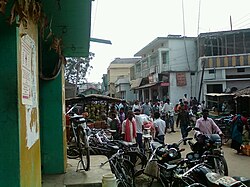
Khariar Old Daily Market
Nuapada district is located in western part of Western Odisha and Khariar is located in the middle of the Nuapada district. Khariar is one of the major towns in Nuapada district and the main business centre in the locality. It has a daily market and a weekly bazaar which takes place every Friday.
As of the 2011 Indian census, Khariar has a population of 15,087. Males constitute 51% of the population and females 49%. Khariar has an average literacy rate of 62%, higher than the national average of 59.5%. The male literacy is 72%, and female literacy is 52%. In Khariar, 13% of the population is under 6 years of age.
Odia is the official language of Khariar. Hindi is also spoken in Khariar. English is widely used for official purposes. And commonly spoken language among people is koshali (sambalpuri).
Khariar Mahotsav
Transportation
Khariar is a major transportation hub in Nuapada District as people from the three blocks, namely Boden, Sinapali and Khariar. Though Khariar is not connected by rail, it is well connected by roads. The major roads passing through Khariar are NH 353 (Khariar-Raipur), NH 59 (Khariar-Gopalpur), SH 16 (Khariar-Sambalpur), and SH 44 (Khariar-Bhawanipatna). The nearest rail head is Kantabanji, which is situated 35km from Khariar.[6] Another nearby railway station is Titlagarh (which is also the hottest place in India). The nearest airport is Raipur Airport, situated 195 kilometres (121mi) from Khariar.
Khariar is connected by bus via the NH 353 & NH 59. As of 2023[update], railway line survey work is in progress for the 220-kilometre (140mi) Kantabanji-Rajkhariar-Ammapani-Nawarangpur-Jeypore route.[citation needed]
There are several religious places of different religions in Khariar. Some of the temples located in Khariar are:
Maa Dukuribudhi Gudi, Duajhar
Maa Samaleswari Temple, near Azad Chowk
Raktambari Mandir, near Azad Chowk
Hanuman Mandir, near Azad Chowk
Hanuman Mandir, Puruna Bustand
Dadhibamana Mandir, Badgudipada
Sri Sri Radha Krishna Temple Chanabeda
Jagannath Temple
Ram Mandir
Hanuman Mandir, irrigation colony
Koshaleswar Temple, irrigation colony
Ganesh Mandir, irrigation colony
Bhubaneswari Mandir, irrigation colony
Shiva Temple, Duajhar
Maa Santoshi Mandir, Junen
Radha Krishna Mandir, Junen
Siva Mandir, Tirbandh
Siva Mandir, Muktasagar
Gayatri Mandir, Chalanpada
Radhakrushna Madir, Damapala
Shri Rameswara Siva Mandir, Bhaludungari
Shiv Temple, Dalpada
Some of the other religious places of other communities are:
Mukti Marg Church, Khariar
Sunni Hanfi Jama Masjid, Khariar
Sunni Jamat Eidgah, Khariar
Places of interest
Tourist destinations
There are several tourist spots around Khariar, including:
Mini Water Dam Project, Duajhar (Salepada) | this is a mini water dam or reservoir located approximately 9km from khariar
Patalganga: A spring located approximately 30km from Khariar which attracts pilgrims from different parts of Nuapada district as well as from neighbouring districts.[7]
Tikhali Dam: Officially known as the Lower Indra Irrigation Project, this dam is situated 17km from Khariar.
Rusi Pitha: Rusipitha (Risipiti) is located in Tukla.
Jogimatha-Tukla is an old site for the monks near these areas. There we can find the ancient inscriptions of religious monks.
Ramgarh Hill: A place of worship of Maa Gadiaan, Goddess of Gandabahali village. A large elephant stone is located at this place, and it is considered to be the oldest such stone in the undivided Kalahandi district. According to an ancient belief, Rama's brother Lakshman and wife Sita resided here in their period of exile.
Markets
Daily Market (fresh market)
Goru/Sukrabar Bazar (weekly)
New Daily Market (near old bus stand)
Machh Bazaar (old daily market)
New Machh/Mansh Bazaar (Boden Chowk-Gadramunda area)
Culture
Khariar's culture is a blend of traditional festivals, food, dance etc. Khariar has a cultural heritage that arose due to intermingling of different religions. The major language used is Sambalpuri/ Kosli, which is widely used in each and every part of Khariar region. Nuakhai is the major festival celebrated in this region. The other festivals like Rathayatra, Dusshera, Holi, Diwali, Eid, Christmas, Chindaguda Duajhar (Dhanujatra, Anchalika Sanskrutik Utsav) are also celebrated in Khariar. Khariar organises Khariar Mahotsav[8] every year, which attracts a large number of people from different places.[9]
The activities of this town include running of schools, shops or very small industries and bus communications. Other than these activities, political activities across the town are also common.
This page is based on this Wikipedia article Text is available under the CC BY-SA 4.0 license; additional terms may apply. Images, videos and audio are available under their respective licenses.