Kumta

Last updated

Kumta
ಕುಮಟಾ
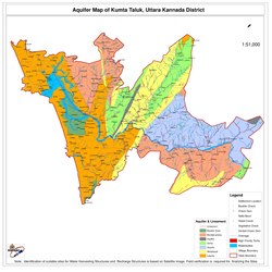
Aquifer Map of Kumta Taluk.pdf
Taluk Map of Kumta
India Karnataka location map.svg
Red pog.svg
Kumta
Location in Karnataka, India
Coordinates: 14°25′N74°24′E / 14.42°N 74.4°E / 14.42; 74.4
Country Flag of India.svg  India
State Karnataka
Region Karavali
District Uttara Kannada
Government
  TypeTown Municipal Council
   MLA Dinakar Keshav Shetty
Area
  Total15.34 km2 (5.92 sq mi)
  Rank9th
Elevation
2 m (7 ft)
Population
 (2011)
  Total29,266
  Rank3rd in UK
  Density1,957.2/km2 (5,069/sq mi)
Languages
  Official Kannada
Time zone UTC+5:30 (IST)
PIN
581 343
Telephone code +91-(0)8386
Vehicle registration KA-47
Lok Sabha Constituency Uttara Kannada (Lok Sabha constituency)
Climate Monsoon (Köppen)
Website kumatatown.mrc.gov.in

Kumta is a town and taluk in the Uttara Kannada district of Karnataka, India. [1] It is one of the important stations along the Konkan Railway line running between Mumbai and Mangalore. [2]

Contents

The 36th Kannada Sahithya Sammelana was held in Kumta in 1956, under the presidency of V. Seetharamaiah.

Geography

The city of Kumta is located on the Arabian Sea coast in the district of North Kannada in the state of Karnataka. Kumta is adjacent to the vast western ghats 14°25′N74°24′E / 14.42°N 74.4°E / 14.42; 74.4 . It has an average elevation of 3 metres (9 feet).

To the north of city, the major Aghanashini river joins the Arabian Sea on her way rendering stunning scenery. The town of Gokarna near Kumta is famous for beaches. A nearby Rock Climbing spot called Yana is also beautiful with its massive black rock formations and nature trails.[ citation needed ]

Mirjan Fort, originally built in the 15th century Front e view of Mirjan fort1.jpg
Mirjan Fort, originally built in the 15th century

Transportation

Road

Kumta is very well connected by road. One of the busiest highway National Highway 66 (NH 66-Panvel-Kochi-Kanyakumari) passes through Kumta. Kumta is also connected to State Highway-142 (SH 142 - Kumta-Sirsi) and also to Kumta-Siddapur Road It connects the NH 69 in Talaguppa. The halkar village situated in near NH66.

The North Western Karnataka Road Transport Corporation (NWKRTC) is the state run bus service in Kumta.[ citation needed ]

Rail

Kumta station is served by the Netravati Express train run by Konkan Railways. [3]

Kumta rail connects Mangalore and Goa which further connects to Bombay) Kumta station is also served by Matsyagandha Express, CSMT Manglore Express and many more

See also

Related Research Articles

<span class="mw-page-title-main">Uttara Kannada</span> District of Karnataka, India

Uttara Kannada is a district in the Indian state of Karnataka. It is a major coastal district of Karnataka, and is the third largest district in Karnataka. It is bordered by the state of Goa and Belagavi districts to the north, Dharwad District and Haveri District to the east, Shivamogga District, and Udupi District to the south, and the Laccadive Sea to the west.

<span class="mw-page-title-main">Netravati River</span> River in Karnataka, India

The Netravati River or Netravathi Nadi has its origins at Bangrabalige valley, Yelaneeru Ghat in Kudremukh in Chikkamagaluru district of Karnataka, India. This river flows through the famous pilgrimage place Dharmasthala and is considered one of the holy rivers of India. It merges with the Kumaradhara River at Uppinangadi before flowing to the Arabian Sea, south of Mangalore city. This river is the main source of water to Bantwal and Mangalore. The Netravati railway bridge is one of the known bridges which serve as the gateway to Mangalore.

<span class="mw-page-title-main">Shirali</span> Village in Karnataka, India

Shirali is a village in Bhatkal taluk of Uttara Kannada district in Karnataka. Shirali is home to two prominent temples: the Chitrapur Math and the Maha Ganapathi Mahammaya Temple. The Chitrapur Math is the holiest temple of the Chitrapur Saraswat Brahmin community, and the Maha Ganapathi Mahammaya temple is the Kuladev to the Kamaths, Bhats, Puraniks, Prabhus, Joishys, Mallyas, Kudvas and Nayak families from the Goud Saraswat Brahmin community.

<span class="mw-page-title-main">Surathkal</span> Neighbourhood/Suburb in Dakshina Kannada, Karnataka, India

Surathkal is one of the major localities in the northern part of Mangalore city located on National highway 66 in the Dakshina Kannada district, Karnataka state, India on the shore of Arabian sea. It is a municipality merged with Mangalore City Corporation. It lies between Gurupura (Phalguni) and Pavanje (Nandini) rivers. It is the northern suburb and can be considered as the northernmost area of Mangalore City until Mukka. Surathkal has a railway station on Konkan railway route which connects cities of Mumbai to Mangaluru. Surathkal is 8 km north of New Mangalore seaport, 4 km west of Mangalore Refinery and Petrochemicals Limited and 16 km west of Mangalore International Airport This region has developed educationally, industrially and commercially can be regarded as one of the crucial localities in Mangaluru and coastal Karnataka. The only NIT of Karnataka is situated here which is adjacent to the national highway NH 66. Mukka a popular name in Indian surfing is also situated close to Surathkal. Surathkal beach is well known for its cleanliness and well maintained like other beaches in Mangalore.

<span class="mw-page-title-main">Pernem taluka</span> Sub-District in Goa, India

Pernem is a northmost administrative region or sub-district in North Goa in India. It acts as the Gateway of Goa from Maharashtra side. It is also the name of the town of Pernem, which is its headquarters. It has a Municipal Council. Geographically, Pernem is surrounded by Sawantwadi sub-district on East, Arabian Sea on West, Bardez and Bicholim sub-district on south and Sawantwadi sub-district on north. The two rivers which decide the boundary of this sub-district are Terekhol River and Chapora River. Terekhol river acts as a border of Maharashtra and Goa while Chapora river acts as a border of Pernem sub-district and Bardez sub-district.

<span class="mw-page-title-main">Udupi district</span> District of Karnataka in India

Udupi district is an administrative subdivision in the Karnataka state of India, with the district headquarters in the city of Udupi. It is situated in the Canara old north malabar coastal region, there are seven taluks, 233 villages and 21 towns in Udupi district. The three northern tehsils of Udupi, Kundapur and Karkala, were partitioned from Dakshina Kannada district to form Udupi district on 25 August 1997. Moodabidri was officially declared as new tehsil (taluk), separated from Karkala with effect from 11 January 2018.

<span class="mw-page-title-main">Gokarna, Karnataka</span> Tourist destination in Karnataka

Gokarna is a small temple town located in the Uttara Kannada district of Karnataka state in southern India, It has a population of around 20,000. Shiva is the most worshipped deity in the town. Gokarna's main temple, Mahabaleshwara, is dedicated to Shiva. The temple houses what is believed by some to be the earliest Shiva lingam (Atmalinga).

Karnataka's coastline called Karavali stretches 300 km between Mangalore in Dakshina Kannada district and Karwar in Uttara Kannada district. The coastline of Karnataka has been along the eastern shore of Arabian Sea. Karnataka has one major and ten minor ports in this coastal belt. Kali, Belekeri, Gangavali, Aghanashini Sharavathi, Sharabi, Kollur, Gangolli, Sitanadi, Gurpur and Netravati are the important rivers in this belt which empty into the Arabian sea. Sea erosion, migration of river mouths, siltation of ports and harbours are some of the problems common to this belt.

<span class="mw-page-title-main">Uppala</span> Town in Kerala, India

Uppala is a town and Headquarters of Manjeshwaram Taluk in Kasaragod district, Kerala, India. It is geographically located midway from Kasaragod to Mangalore. Easy geographical access and lack of major towns nearby are the key reasons for the town to develop exponentially, especially in the past decade. The population of Manjeshwaram Taluk alone was over 268,642 as of 2011. Uppala is 22 km north of Kasaragod and one of the fastest growing urban settlements in Kasaragod district. It is well known as an important trade hub in the northernmost part of Kerala state.

<span class="mw-page-title-main">Netravati Express</span> Train in India

The Netravati Express (16345/46) is a daily Express train connecting capital cities of Kerala and Maharashtra. It operates between Thiruvananthapuram Central and Lokmanya Tilak Terminus. The train runs on the Konkan Railway.

Bankikodla and Hanehalli are the twin neighbouring villages in a valley in Uttara Kannada district in the Indian state of Karnataka.

Mangalore's location in the Indian state of Karnataka makes it accessible by all forms of transport: road, rail, air and sea. It is the largest city in the Coastal Karnataka region, and is the only city in Karnataka and one among the six cities in India to have an International Airport, a Major Seaport, railway & road connectivities. It is the second prominent city of Karnataka after the state capital Bangalore in all aspects. It is one of the fastest developing cities in India.

<span class="mw-page-title-main">Sadashivgad</span> Village located in Karwar District

Sadashivgad is a village located in Karwar, Uttara Kannada district, in the state of Karnataka in India. Significant and picturesque, it is now a popular tourist destination located by the Kali river bridge, which has been built at the confluence of the river and the Arabian Sea.

Kadekodi is a small village situated on the National Highway 17 (NH17) on the way from Honnavar to Kumta. Kadekodi is part of Kumta Taluk, Uttara Kannada district, Karnataka State

National Highway 66, commonly referred to as NH 66, is a mostly 4 lane 1640 km long busy National Highway that runs roughly north–south along the western coast of India, parallel to the Western Ghats. It connects Panvel, a city east of Mumbai to Cape Comorin (Kanyakumari), passing through the states of Maharashtra, Goa, Karnataka, Kerala and Tamil Nadu.

<span class="mw-page-title-main">Netravati Bridge</span> Bridge in Karnataka, India

Netravati Bridge is on NH 66 in Mangalore, Dakshina Kannada, Karnataka, India, built over Netravati River, which connects Mangalore city with its southern suburbs Thokottu, Ullal and Deralakatte. This bridge is also called Ullal Bridge as this bridge is located in the town called Ullal in Mangalore taluk.

<span class="mw-page-title-main">Panambur Beach</span> Beach in Mangalore, Panambur

Panambur Beach is a beach on the shores of the Arabian Sea in the city of Mangalore in the Indian state of Karnataka.

<span class="mw-page-title-main">Transport in Kannur district</span>

Kannur has a good road network connecting to Bangalore, Mangalore, Kodagu and Cochin. The railway station is also well connected to all parts of India. There is new International airport from Kannur opened on 9 December 2018, other nearest airports are at Calicut and Mangalore. Thalassery, Payyanur, Taliparamba and Iritty are the other transport hubs.

<span class="mw-page-title-main">Surathkal railway station</span> Railway station in Karnataka, India

Surathkal railway station is one of the main railway stations of Mangalore city along with Mangalore Central railway station and Mangalore Junction railway station and is located in north Mangaluru on Konkan Railway route. Twenty-two trains stop here.KRCL operates RO-RO services from Suratkal to Verna, Kolad, and Karembeli. As per the Konkan railway map, Surathkal railway station is at a distance of 733.825 kilometers from the northern starting point of the Konkan railway line at Roha and 4.615 kilometers from Thokur which is the southern endpoint of Konkan railway jurisdiction. The Surathkal railway station is at distance of 26.285 Kilometre from Mangaluru Central(MAQ) railway station.

<span class="mw-page-title-main">Mookambika Road Byndoor railway station</span> Railway station in Karnataka, India

Mookambika Road Byndoor is a railway station in coastal Karnataka in South India. Its four-letter code is BYNR. Mookambika Road Byndoor is the main railway station in the town of Byndoor in Udupi district. It serves Byndoor city which is 1 kilometre away from the station. It is the nearest railway station to the famous pilgrimage centre, Kollur Mookambika temple. The distance from Byndoor railway station to Kollur Mookambika temple is about 28 km which can be covered in 40 minutes to one hour by road. Trains from here connect the city to prominent state capitals of India like Bangalore (Karnataka), Thiruvananthapuram, Mumbai and so forth. It is also well connected to the major railway stations such as Goa (Madgoan), Udupi, Mangalore, Kasaragod and Ernakulam. Rail connectivity in Byndoor was established in 1997. A total of 34 express and passenger trains halt here; there was one originating and terminating trains at this station: Mookambika Road–Kannur Passenger train; however this service was terminated in 2017 within two years of service due to lack of revenue generation. Although the railway station caters to a lot of passengers and superfast trains on a daily basis, it does not have a siding line or passing loop. Any crossing of trains can only happen either on Bijoor or Shiroor railway stations 19 km apart.

References

  1. "Unauthorized Request Blocked". Archived from the original on 15 February 2017. Retrieved 15 February 2017.
  2. "Kumata TMC". Kumta Town Municipal Council.
  3. "(Train Schedule / 16345 Netravati Express)". Passenger Info. Konkan Railways . Retrieved 28 October 2018.