Uttara Kannada is a district in the Indian state of Karnataka. It is a major coastal district of Karnataka, and is the third largest district in Karnataka. It is bordered by the state of Goa and Belagavi districts to the north, Dharwad District and Haveri District to the east, Shivamogga District, and Udupi District to the south, and the Laccadive Sea to the west.

Manipal is a suburb and university town within Udupi, in coastal Karnataka, India. Manipal is located five kilometres away from the centre of Udupi City, in Udupi District, Karnataka (state) in south western India. It is administered by the Udupi City Municipality. The suburb is located in coastal Karnataka, 62 km north of Mangalore and 8 km east of the Arabian Sea. From its location on a plateau, at an altitude of about 75 metres above sea level, it commands a panoramic view of the Arabian Sea to the west and the Western Ghats to the east.

Shirali is a village in Bhatkal taluk of Uttara Kannada district in Karnataka. Shirali is home to two prominent temples: the Chitrapur Math and the Maha Ganapathi Mahammaya Temple. The Chitrapur Math is the holiest temple of the Chitrapur Saraswat Brahmin community, and the Maha Ganapathi Mahammaya temple is the Kuladev to the Kamaths, Bhats, Puraniks, Prabhus, Joishys, Mallyas, Kudvas and Nayak families from the Goud Saraswat Brahmin community.

Gokak is a taluka headquarters in the Belagavi district of Karnataka state, India. It is located around 70 km from Belagavi at the confluence of two rivers, the Ghataprabha and the Markandeya. The population of the city is according to 2011 census is 79,121. Gokak city has second highest GDP in the district of Belagavi after Belagavi city. The common language is Kannada.

Mattanur, also spelled Mattannur, is a town, municipality, and an aerotropolis in Kannur district, Kerala, India. Mattanur is about 27 km east of Kannur and Thalassery, two major towns of the district.

Chikmagalur is a city and the headquarters of Chikmagalur district in the Indian state of Karnataka. Located on the foothills of the Mullayanagiri peak of the Western Ghats, the city attracts tourists from around the world for its pleasant and favourable hill station climate, tropical rainforest and coffee estates. The pristine Baba Budangiri lies to the north of Chikmagalur where it's believed Baba Budan first introduced coffee to India.

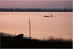
Kumta is a town and taluk in the Uttara Kannada district of Karnataka, India. It is one of the important stations along the Konkan Railway line running between Mumbai and Mangalore.
The town of Virajpet also spelled as Virajapete is town of the district of Kodagu, in India's southern State of Karnataka. It is the main town of the Virajpet taluka, south of the district, and borders Kerala State. The name of the town is derived from its founder, Dodda Vira Rajendra.
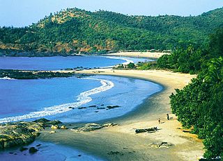
Gokarna is a small temple town located in the Uttara Kannada district of Karnataka state in southern India, It has a population of around 20,000. Shiva is the most worshipped deity in the town. Gokarna's main temple, Mahabaleshwara, is dedicated to Shiva. The temple houses what is believed by some to be the earliest Shiva lingam (Atmalinga).

Sirsi is a city and a taluk headquarter in Uttara Kannada district of Karnataka state in India. It was also known as Kalyana Pattana during the Sonda Dynasty. It is a tourist destination with evergreen forest and waterfalls and is also a commercial centre. The main businesses around the city are mostly subsistence and agriculture-based. Areca nut or betel nut, locally known as Adike, is the primary crop grown in the nearby villages, making it one of the major trading centres for areca nut. The region is also known for spices such as cardamom, pepper, betel leaves, and vanilla. The major food crop is paddy.
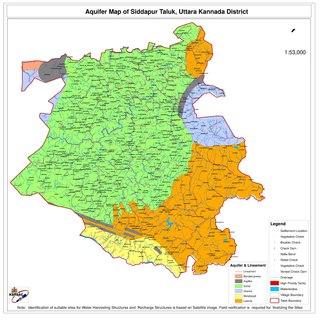
Siddapur Taluk is the destination of world famous Jog Falls. It is a part of Uttara Kannada district, Karnataka, India and is located in the midst of forest areas of Western Ghats and it is also a part of Malenadu. The taluk is full of greenery, hills and arecanut gardens developed in the valleys’. The taluk headquarters is Siddapur. Sirsi is the nearest city,
Chandgad is a Small city and tehsil headquarters of chandgad taluka, of Kolhapur district that is in the Indian state of Maharashtra.
Bankikodla and Hanehalli are the twin neighbouring villages in a valley in Uttara Kannada district in the Indian state of Karnataka.
Bijjur is a small village of gokarna in Uttar Kannada district are neighbouring villages in a valley in the south western section of Karnataka, India. Together they form a community of people from different castes and religions.
Kadekodi is a small village situated on the National Highway 17 (NH17) on the way from Honnavar to Kumta. Kadekodi is part of Kumta Taluk, Uttara Kannada district, Karnataka State
Charekone is a small village in Siddapura Taluk Uttara Kannada District, Karnataka State; Which is about 32 kilometres (20 mi) from Sirsi and 28 kilometres (17 mi) from Siddapur.
National Highway 66, commonly referred to as NH 66, is a mostly 4 lane 1640 km long busy National Highway that runs roughly north–south along the western coast of India, parallel to the Western Ghats. It connects Panvel, a city east of Mumbai to Cape Comorin (Kanyakumari), passing through the states of Maharashtra, Goa, Karnataka, Kerala and Tamil Nadu.
Karawadi is a village panchayat located in the Karad taluka of Satara district in the southern part of Indian state of Maharashtra. It belongs to Western Maharashtra region. It has a population of 3,588 according to 2011 census. The nearby villages include Ogalewadi, Viravade, Wagheri, Vadoli Nileshwar. Prominent family surnames include Pisal, Dubal, Patil, Chavan, Bhosale, More, Bansode. It is in the Pune Division. It is located 57 km towards South from District headquarters Satara and 278 km from State capital Mumbai.

Mookambika Road Byndoor is a railway station in coastal Karnataka in South India. Its four-letter code is BYNR. Mookambika Road Byndoor is the main railway station in the town of Byndoor in Udupi district. It serves Byndoor city which is 1 kilometre away from the station. It is the nearest railway station to the famous pilgrimage centre, Kollur Mookambika temple. The distance from Byndoor railway station to Kollur Mookambika temple is about 28 km which can be covered in 40 minutes to one hour by road. Trains from here connect the city to prominent state capitals of India like Bangalore (Karnataka), Thiruvananthapuram, Mumbai and so forth. It is also well connected to the major railway stations such as Goa (Madgoan), Udupi, Mangalore, Kasaragod and Ernakulam. Rail connectivity in Byndoor was established in 1997. A total of 34 express and passenger trains halt here; there was one originating and terminating trains at this station: Mookambika Road–Kannur Passenger train; however this service was terminated in 2017 within two years of service due to lack of revenue generation. Although the railway station caters to a lot of passengers and superfast trains on a daily basis, it does not have a siding line or passing loop. Any crossing of trains can only happen either on Bijoor or Shiroor railway stations 19 km apart.

Devimane is a hill station and high-altitude village in Sirsi taluk of Malenadu region in Karnataka, India. The road to reach the village is named Devimane Ghat, and lies in NH 766E ultimately connecting Malenadu city Sirsi and Karavali town Kumta. Being under the lush forest zone in Uttara Kannada District, it consists of 10 hairpin curves with a well-engineered road that reduces the risk of accidents. The road's elevation ranges from 25 to 567 metres. A temple of Goddess Durga Devi is at the beginning of the road at elevation 429m. The ghat section was named after the temple, "Devimane", meaning "the home of goddess Devi". There are 5 hairpins curves between Devimane Temple and Sampakhanda.