Narmada district

Last updated

Narmada District
Statue of Unity - View from the other bank of Narmada.jpg
Zarwani Waterfall, Narmada district, Gujarat, India.jpg
Top: Statue of Unity and Sardar Sarovar Dam
Bottom: Zarwani Waterfall
Narmada district
Interactive Map Outlining Narmada District
Narmada in Gujarat (India).svg
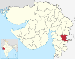
Location of district in Gujarat
Coordinates: 21°52′12″N73°30′0″E / 21.87000°N 73.50000°E / 21.87000; 73.50000
CountryFlag of India.svg  India
State Gujarat
Headquarters Rajpipla
Area
  Total2,755 km2 (1,064 sq mi)
Population
 (2011)
  Total590,297
  Density210/km2 (550/sq mi)
Languages
  Official Gujarati
Time zone UTC+5:30 (IST)
Vehicle registration GJ-22
Website narmada.nic.in

Narmada district is an administrative district in the state of Gujarat in India. The district headquarters are located at Rajpipla. The district is bounded by Vadodara and Chhota Udaipur districts in the north, by Nandurbar district of Maharashtra state in the east, by Surat and Tapi districts in the south and by Bharuch district in the west. The district occupies an area of 2,755 km² and has a population of 590,297 (as of 2011). It was 10.44% urban as of 2011. [1] As of 2011, it is the third least populous district of Gujarat (out of 33), after Dang and Porbandar. [2]

Contents

History

This district was carved out on October 2, 1997. The newly formed district consisted of Tilakwada taluka of erstwhile Vadodara district and 3 talukas of erstwhile Bharuch district: Nandod, Dediyapada and Sagbara. [3]

Administration

The district consists of 5 talukas: Tilakwada, Garudeshwar, Nandod (including Rajpipla), Dediyapada, and Sagbara.
It consists two Vidhan Sabha constituency: Nandod and Dediapada

Economy

In 2006 the Ministry of Panchayati Raj named Narmada one of the country's 250 most backward districts (out of a total of 640). [4] It is one of the six districts in Gujarat currently receiving funds from the Backward Regions Grant Fund Programme (BRGF). [4]

Demographics

Historical population
YearPop.±% p.a.
1901105,930    
1911121,901+1.41%
1921124,941+0.25%
1931142,172+1.30%
1941169,679+1.78%
1951188,765+1.07%
1961244,985+2.64%
1971312,095+2.45%
1981374,940+1.85%
1991449,376+1.83%
2001514,404+1.36%
2011590,297+1.39%
source: [5]

According to the 2011 census Narmada district has a population of 590,297, [2] roughly equal to the nation of Solomon Islands [6] or the US state of Wyoming. [7] This gives it a ranking of 528th in India (out of a total of 640). [2] The district has a population density of 214 inhabitants per square kilometre (550/sq mi) . [2] Its population growth rate over the decade 2001-2011 was 14.77%. [2] Narmada has a sex ratio of 960 females for every 1000 males, [2] and a literacy rate of 73.29%. 10.48% of the population lives in urban areas. Scheduled Castes and Scheduled Tribes make up 1.48% and 81.55% of the population respectively. [2]

Religions in Narmada district (2011) [8]
Hinduism
94.84%
Islam
3.83%
Christianity
0.75%
Other or not stated
0.58%

Languages in Narmada district (2011) [9]

   Gujarati (68.50%)
   Vasavi (26.37%)
   Hindi (1.73%)
   Bhili (0.93%)
  Others (2.47%)

At the time of the 2011 Census of India, 68.50% of the population in the district spoke Gujarati, 26.37% Vasavi, [lower-alpha 1] 1.73% Hindi and 0.93% Bhili as their first language. [9]

Places of interest

Politics

DistrictNo.ConstituencyNamePartyRemarks
Narmada 148 Nandod (ST)Dr. Darshana Deshmukh (Vasava) Bharatiya Janata Party
149 Dediapada (ST) Chaitar Vasava Aam Aadmi Party AAP LP Leader

See also

Related Research Articles

<span class="mw-page-title-main">Sabarkantha district</span> District of Gujarat in India

Sabarkantha district is one of the 33 districts of Gujarat state of India, located in the northeastern part of the state. The administrative headquarters of the district are located in Himatnagar.

<span class="mw-page-title-main">Panchmahal district</span> District of Gujarat in India

Panchmahal, also rendered as Panch Mahal, is a district in the eastern portion of Gujarat State western India. Panch-mahal means "five tehsils/talukas", and refers to the five sub-divisions that were transferred by the Maharaja Jivajirao Scindia of Gwalior State to the British: Godhra, Dahod, Halol, Kalol and Jhalod, Devgadh Baria. The district had a population of 2,390,776 of which 12.51% were urban as of 2001.

<span class="mw-page-title-main">Gondia district</span> District of Maharashtra in India

Gondia district is an administrative district in the state of Maharashtra in India. The district headquarter is located at Gondia. The district occupies an area of 5,234 km2 (2,021 sq mi) and has a population of 1,322,507 of which 11.95% were urban. The district is part of Nagpur Division. There are 8 Talukas in Gondia District. Gondia Airport is second airport in Vidharbha region and serves city of Gondia.

<span class="mw-page-title-main">Nandurbar district</span> District in Maharashtra, India

Nandurbar district is an administrative district in the northwest corner of Maharashtra state in India. On 1 July 1998 Dhule was bifurcated as two separate districts now known as Dhule and Nandurbar. Nandurbar is a tribal-dominated district, The district headquarters are located at Nandurbar city. The district occupies an area of 5955 km2 and has a population of 1,648,295 of which 16.71% were urban.

<span class="mw-page-title-main">Dang district, India</span> District of Gujarat in India

Dang is a district in the southeastern part of the state of Gujarat in western India. The administrative headquarters of the district are located in Ahwa. Dang has an area of 1,764 km2 and a population of 228,291. As of 2011, it is the least populous of Gujarat's 33 districts. As per the Planning Commission, Dang is one of the most economically distressed district out of 640 districts in India. 94% of the population belongs to one of the scheduled tribes. The five Kings of Dangs are the only hereditary royals in India whose titles are currently recognized by the government owing to an agreement between the Government of India and the Dang kings in 1842.

<span class="mw-page-title-main">Navsari district</span> District of Gujarat in India

Navsari is an administrative district in the state of Gujarat in India, with its headquarters at the city of Navsari. The district covers an area of 2,211 square kilometres and was formed in 1997 after Valsad district was split into Valsad and Navsari districts. It is the largest producer of chikoos in India.

<span class="mw-page-title-main">Rajpipla</span> Town in Gujarat, India

Rajpipla is a town and a municipality in the Narmada district in the Indian state of Gujarat.

<span class="mw-page-title-main">Lakhisarai district</span> District of Bihar in India

Lakhisarai district is one of the thirty-eight districts of Bihar state, India, and Lakhisarai town is the administrative headquarters of this district. Lakhisarai district is a part of Munger Division. The district occupies an area of 1,228 km2 (474 sq mi).

<span class="mw-page-title-main">Simdega district</span> District of Jharkhand in India

Simdega district is one of the 24 districts of Jharkhand state, India, and Simdega town is the administrative headquarters of this district. As of 2011, this district is the least densely populated district and the third least populous district of Jharkhand after Lohardaga and Khunti districts. Simdega District was carved out from erstwhile Gumla district on 30 April 2001. It is currently a part of the Red Corridor.

<span class="mw-page-title-main">Sahebganj district</span> District of Jharkhand in India

Sahibganj district is one of the twenty-four districts of Jharkhand state, India, and Sahibganj is the administrative headquarters of this district.

<span class="mw-page-title-main">Betul district</span> District of Madhya Pradesh in India

Betul district is a district of Madhya Pradesh state in central India. The city of Betul serves as its administrative headquarters. The district is a part of Narmadapuram Division.

<span class="mw-page-title-main">Mandla district</span> District of Madhya Pradesh in India

Mandla District is a district of Madhya Pradesh in central India. The town of Mandla is the administrative headquarters of the district. It is part of Jabalpur Division.

<span class="mw-page-title-main">Bhavnagar district</span> District in Gujarat, India

Bhavnagar District is a district of southeastern Gujarat, India, on the Saurashtra peninsula. The administrative headquarters is in the town of Bhavnagar.

<span class="mw-page-title-main">Bharuch district</span> District of Gujarat in India

Bharuch in India, is a district in the southern part of the Kathiawar peninsula on the west coast of state of Gujarat with a size and population comparable to that of Greater Boston. Bharuch derives its name from the famous Hindu sage Bhrigu. A historical name for Bharuch is 'Bhrigukachchha'. The mythological Bhrigu Rishi was said to be one of the ten sons of Brahma. There is also a story which indicates that Bhrigu along with his kin asked for temporary access to Bharuch which was said to belong to Lakshmi, since Bharuch is located on the banks of river Narmada also known as Rudra Deha. Chanra Mauli Mahadev is the Hindu Kul Devata of Bhargavs of Bharuch. Bhrigu never left the place and the Ashram of Brighu Rishi is located on the banks of Narmada. The Narmada River outlets into the Gulf of Khambat through its lands and that shipping artery gave inland access to the kingdoms and empires located in the central and northern parts of the sub-continent of India.

<span class="mw-page-title-main">Khandwa district</span> District of Madhya Pradesh in India

Khandwa district, formerly known as the East Nimar district, is a district of the Madhya Pradesh state in central India. The city of Khandwa is the administrative headquarters of the district. Other notable towns in the district include Mundi, Harsud, Pandhana and Omkareshwar.

Dediyapada is a Tehsil and town in Narmada District with a sizable population of Tribal communities in which Vasava and Tadvi form the majority. This taluka is bounded by Zaghadia taluka (Bharuch), Sagbara taluka, Nandod taluka, Maharashtra state and Mandavi taluka. Dediyapada is well connected with Bharuch, Ankleshwar, Rajpipla, Netrang, Sagbara, Akkalkuva and Shahada by National Highway & State Highway. Despite being remote in location, it is well connected by Gujarat and Maharashtra ST Buses.

'Sagbara is a Town in Sagbara Taluka in Narmada District of Gujarat State, India. It is located 55 KM towards South from District head quarters Rajpipla. It is a Taluka head quarter.. Its location is at NH-753B Ankleshwar-Valia-Netrang-Dediapada-Sagbara up to State Border to Akkalkuva in Maharashtra

<span class="mw-page-title-main">Chhota Udaipur district</span> District of Gujarat in India

Chhota Udaipur district is a district in the state of Gujarat in India. It was carved out of the Vadodara district on 26 January 2013 with its headquarters at Chhota Udaipur town and is the 28th district of Gujarat.

<span class="mw-page-title-main">Dediyapada taluka</span> Taluka in Gujarat, India

Dediyapada is a taluka in Narmada district, Gujarat, India. This taluka is bounded by Zaghadia taluka, Sagbara taluka, Nandod taluka, Maharashtra state and Mandavi taluka. Dediyapada is well connected with Ankleshwar, Rajpipla, Sagbara and Shahada by state highway.

References

  1. "Census GIS India". Archived from the original on 11 January 2010. Retrieved 20 November 2010.
  2. 1 2 3 4 5 6 7 "District Census Hand Book – Narmada" (PDF). Census of India . Registrar General and Census Commissioner of India.
  3. "About District". Narmada District Panchayat.
  4. 1 2 Ministry of Panchayati Raj (8 September 2009). "A Note on the Backward Regions Grant Fund Programme" (PDF). National Institute of Rural Development. Archived from the original (PDF) on 5 April 2012. Retrieved 27 September 2011.
  5. Decadal Variation In Population Since 1901
  6. US Directorate of Intelligence. "Country Comparison:Population". Archived from the original on 13 June 2007. Retrieved 1 October 2011. Solomon Islands 571,890 July 2011 est.
  7. "2010 Resident Population Data". U. S. Census Bureau. Retrieved 30 September 2011. Wyoming 563,626
  8. "Population by Religion - Gujarat". censusindia.gov.in. Registrar General and Census Commissioner of India. 2011.
  9. 1 2 "Table C-16 Population by Mother Tongue: Gujarat". censusindia.gov.in. Registrar General and Census Commissioner of India.

Notes

  1. Census records where people are erroneously recorded as speaking Haryanvi are places where Vasava tribals dominate