Dahod district

Last updated
Dahod district
Dohad
Bavaka,shiv mandir at dahod,gujarat india (4).jpg
Ratanmahal Waterfalls.jpg
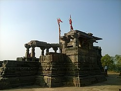
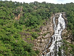
Top: Bavaka Shiva temple
Bottom: Falls in Ratanmahal Wildlife Sanctuary
Dahod district
Interactive Map Outlining Dahod District
Dahod in Gujarat (India).svg
Location of district in Gujarat
Coordinates: 22°50′2″N74°15′28″E / 22.83389°N 74.25778°E / 22.83389; 74.25778
CountryFlag of India.svg  India
State Gujarat
Collector & DMDr. Harshit Gosavi I.A.S.
Headquarters Dahod
Area
  Total3,642 km2 (1,406 sq mi)
Population
 (2011)
  Total2,127,086
  Density580/km2 (1,500/sq mi)
Languages
  Official Gujarati, Hindi, English
Time zone UTC+5:30 (IST)
Vehicle registration GJ 20
Website dahod.gujarat.gov.in

Dahod district is a district of Gujarat state in western India. This largely tribal district is mostly covered by forests and hills.

Contents

Geography

Dahod is located in eastern Gujarat. It is located at the tripoint between Gujarat, Rajasthan and Madhya Pradesh. It borders Rajasthan to the north, Madhya Pradesh to the east, Chhota Udaipur district to the south, Panchmahal district to the west and Mahisagar district to the north. The district has two areas: a region of scrubland in the western part of the district and hills in the east. All these areas are covered by forests. The district has several rivers flowing through it: the Panam, Khan, Kalutari, Machhan and Anas. These rivers are tributaries of the Mahi.

History

Aurangzeb was born in Dahod in 1648. [1]

Before Indian independence in 1948, Dahod district was part of the Sunth princely state. In October and November 1913 its villages were raided by the Bhils under Govindgiri who were encamped in the Mangarh Hills to the northeast. [2]

Demographics

Historical population
YearPop.±% p.a.
1901177,555    
1911229,553+2.60%
1921267,075+1.53%
1931317,838+1.76%
1941365,700+1.41%
1951437,189+1.80%
1961580,397+2.87%
1971742,363+2.49%
1981946,588+2.46%
19911,274,123+3.02%
20011,636,433+2.53%
20112,127,086+2.66%
source: [3]

It was 8.99% urban at the 2001 census. [4] The population of the district is mostly rural, and a majority of the district's residents are tribals, mostly Bhils. Dahod District also has the second largest population of the Dawoodi Bohra sect of Ismā'īlī Muslims in India.

Religions in Dahod district (2011) [5]
Hinduism
96.15%
Islam
3.12%
Christianity
0.47%
Other or not stated
0.26%

At the 2011 census Dahod District had a population of 2,127,086, [6] roughly equal to the nation of Namibia [7] or the US state of New Mexico. [8] It was the 215th most populous district in India (out of a total of 640). [6] The district had a population density of 582 inhabitants per square kilometre (1,510/sq mi). [6] Its population growth rate over the decade 2001–2011 was 29.95%. [6] It had a sex ratio of 986 females for every 1000 males, [6] and a literacy rate of 60.6%. 9.01% of the population lived in urban areas. Scheduled Castes and Scheduled Tribes made up 1.95% and 74.32% of the population respectively. [6]

Languages of Dahod district (2011) [9]

   Gujarati (96.29%)
   Bhili (2.14%)
   Hindi (1.18%)
  Others (0.39%)

At the time of the 2011 Census of India, 96.29% of the population in the district spoke Gujarati, 2.14% Bhili and 1.18% Hindi as their first language. [9]

Politics

DistrictNo.ConstituencyNamePartyRemarks
Dahod 129 Fatepura (ST)Rameshbhai Katara Bharatiya Janata Party
130 Jhalod (ST)Maheshbhai Bhuriya Bharatiya Janata Party
131 Limkheda (ST)Shaileshbhai Bahbhor Bharatiya Janata Party
132 Dahod (ST)Kanaiyalal Kishori Bharatiya Janata Party
133 Garbada (ST)Mahendrabhai Bhabhor Bharatiya Janata Party
134 Devgadhbariya Bachubhai Khabad Bharatiya Janata Party

Education

There is a government polytechnic college since 1963 and it was started by Indian prime minister Mr. Moraraji Desai and now government degree engineering college [10] is also there. The degree college is affiliated to Gujarat University.

Economy

Engineering

Dahod is a city in the Indian state of Gujarat, and it is home to a growing engineering sector. The city has a number of small and medium-sized engineering firms that specialize in areas such as metal fabrication, machining, and tool and die making. Additionally, there are several larger companies that have established manufacturing operations in Dahod, including Siemens India, which plans to manufacture and maintain freight locomotives at its facility in the city. [11] [12] [13] [14] [15] [16]

Ratan Mahal Sanctuary

Entrance gate of the sanctuary Ratanmahal Wildlife Sanctuary - Dahod district - Gujarat - DSC0001.jpg
Entrance gate of the sanctuary
Birds of Chougania chirping merrily as the Sun breaks out of overcast sky

Ratanmahal Wildlife Sanctuary is a mixed, deciduous forest, located near Devgadh Baria in Dohad district, [17] at Gujarat's border with Madhya Pradesh, within the Kathiawar-Gir dry deciduous forests' ecoregion. [18] The maximum area covered is in Gujarat. Ratanmahal Sanctuary is near by River Paanam (a major river of Central Gujarat), which helps to preserve the ecological balance in the forest, besides water conservation. The sanctuary is also known as "Ratanmahal Sloth Bear Sanctuary," due to its population of sloth bears. [19] As with Purna Wildlife Sanctuary, Ratanmahal has experienced extinctions in its population of birds. [20]

See also

Related Research Articles

<span class="mw-page-title-main">Dahod</span> City in Gujarat, India

Dahod is a city on the banks of the Dudhimati River in Dahod District in the State of Gujarat, India. It is said that it has taken its name from Saint Dadhichi, who had an Ashram on the bank of Dudhumati river. The city serves as District Headquarters for Dahod District. It is 214 kilometres (133 mi) from Ahmedabad and 159 kilometres (99 mi) from Vadodara. It is also known as Dohad.

<span class="mw-page-title-main">Gir National Park</span> Forest, national park, and wildlife sanctuary in Gujarat, India

Gir National Park and Wildlife Sanctuary, also known as Sasan Gir, is a forest, national park, and wildlife sanctuary near Talala Gir in Gujarat, India. It is located 43 km (27 mi) north-east of Somnath, 65 km (40 mi) south-east of Junagadh and 60 km (37 mi) south-west of Amreli. It was established in 1965 in the erstwhile Nawab of Junagarh's private hunting area, with a total area of 1,410.30 km2 (544.52 sq mi), of which 258.71 km2 (99.89 sq mi) is fully protected as a national park and 1,151.59 km2 (444.63 sq mi) as wildlife sanctuary. It is part of the Khathiar-Gir dry deciduous forests ecoregion.

<span class="mw-page-title-main">Dang district, India</span> District of Gujarat in India

Dang is a district in the southeastern part of the state of Gujarat in western India. The administrative headquarters of the district are located in Ahwa. Dang has an area of 1,764 km² and a population of 228,291. As of 2011, it is the least populous district of Gujarat. As per the Planning Commission, Dang is one of the most economically distressed district out of 640 districts in India. 94% of the population belongs to one of the scheduled tribes. The five Kings of Dangs are the only hereditary royals in India whose titles are currently recognized by the government owing to an agreement made during the British Raj in 1842.

<span class="mw-page-title-main">Navsari district</span> District of Gujarat in India

Navsari is an administrative district in the state of Gujarat in India, with its headquarters at the city of Navsari. The district covers an area of 2,211 square kilometres and was formed in 1997 after Valsad district was split into Valsad and Navsari districts. It is the largest producer of chikoos in India.

Banswara is a city in the Banswara district in southern Rajasthan, India. The name, Banswara, came from king ‘Bansiya Bhil’

<span class="mw-page-title-main">Mewar</span> Region in the Indian state of Rajasthan

Mewar or Mewad is a region in the south-central part of Rajasthan state of India. It includes the present-day districts of Bhilwara, Chittorgarh, Pratapgarh, Rajsamand, Udaipur, Pirawa Tehsil of Jhalawar District of Rajasthan, Neemuch and Mandsaur of Madhya Pradesh and some parts of Gujarat.

<span class="mw-page-title-main">Khathiar–Gir dry deciduous forests</span> Ecoregion in India

The Khathiar–Gir dry deciduous forests is a mostly arid ecoregion in northwestern India that stretches over 103,100 sq mi (267,000 km2) across Gujarat, Rajasthan and Madhya Pradesh. The dry deciduous forests in the region are dominated by teak, and thorny trees and scrub in drier areas.

<span class="mw-page-title-main">Vagad</span>

Vagad is a region in southeastern Rajasthan state of western India. Its boundaries are roughly defined by those of the districts of Dungarpur and Banswara. Major cities of the region are Dungarpur and Banswara.

<span class="mw-page-title-main">Kumbhalgarh Wildlife Sanctuary</span> Wildlife sanctuary in India

Kumbhalgarh Wildlife Sanctuary is located in the Rajsamand District of Rajasthan State in western India. It surrounds the Kumbhalgarh fortress and covers an area of 610.528 km2 (236 sq mi). The sanctuary extends across the Aravalli Range, covering parts of Rajsamand, Udaipur, and Pali districts, ranging from 500 to 1,300 metres in elevation. It is part of the Khathiar-Gir dry deciduous forests ecoregion.

<span class="mw-page-title-main">Banswara district</span> District of Rajasthan in India

Banswara District has an area of 5,037 km2 (1,945 sq mi), which is 1.47% of Rajasthan state, India. The city of Banswara is the district headquarters. It is bounded on the north by Udaipur District, on the northeast by Pratapgarh District, on the east and southeast by Madhya Pradesh state, on the southwest by Gujarat state, and on the west by Dungarpur District.

<span class="mw-page-title-main">Vansda National Park</span> National park in Gujarat, India

Vansda National Park, also known as Bansda National Park, is a protected area which represents the thick woodlands of the Dangs and southern Gujarat, and is situated in the Vansda tehsil, Navsari District of Gujarat state, India. Riding on the banks of Ambika River and measuring roughly 24 km2 in area, the park lies about 65 km east of the town of Chikhali on the National Highway 48, and about 80 km northeast of the city of Valsad. Vansda, the town from which the name of the park is derived, is an important trading place for the surrounding area where the majority of the population is represented by adivasis. Vansda-Waghai state highway runs through the park, so does the narrow gauge rail link connecting Waghai to Billimora.

<span class="mw-page-title-main">Narmada Valley dry deciduous forests</span> Ecoregion in India

The Narmada Valley dry deciduous forests are a tropical dry forest ecoregion of central India. The ecoregion lies mostly in Madhya Pradesh state, but extends into portions of Chhattisgarh, Maharashtra, Karnataka and Uttar Pradesh states.

Kuno National Park is a national park and Wildlife Sanctuary in Madhya Pradesh, India. It derives its name from Kuno River. It was established in 1981 as a wildlife sanctuary with an initial area of 344.686 km2 (133.084 sq mi) in the Sheopur and Morena districts. In 2018, it was given the status of a national park. It is part of the Khathiar-Gir dry deciduous forests ecoregion.

<span class="mw-page-title-main">Asiatic Lion Reintroduction Project</span>

The Asiatic Lion Reintroduction Project is an initiative of the Indian Government to provide safeguards to the Asiatic lion from extinction in the wild by means of reintroduction. The last wild population of the Asiatic lion is found in the region of Gir Forest National Park, in the state of Gujarat. The single population faces the threats of epidemics, natural disasters and other anthropogenic factors. The project aims to establish a second independent population of Asiatic lions at the Kuno National Park in the Indian state of Madhya Pradesh. However, the proposed translocation has been bitterly contested by the state government.

<span class="mw-page-title-main">Gandhi Sagar Sanctuary</span> Wildlife sanctuary in India

Gandhi Sagar Sanctuary is a wildlife sanctuary situated on the northern boundary of Mandsaur and Nimach districts in Madhya Pradesh, India. It is spread over an area of 368.62 km2 (142.32 sq mi) adjoining Rajasthan state in India. It was notified in 1974 and more area was added in 1983. The Chambal River passes through the sanctuary dividing it into two parts. The western part is in Nimach district and eastern part is in Mandsaur district. It is in the Khathiar-Gir dry deciduous forests ecoregion.

<span class="mw-page-title-main">Jambughoda Wildlife Sanctuary</span> Wildlife samctuary in India

Jambughoda is a Wildlife Sanctuary situated in Jambughoda Tehsil, in the South-Central part of Gujarat, and the Khathiar-Gir dry deciduous forests' ecoregion in India. It is located 70 km from Vadodara and 20 km from prominent tourist places such as Pawagadh and Champaner.

<span class="mw-page-title-main">Purna Wildlife Sanctuary</span> Wildlife Sanctuary in Gujarat, India

Purna Wildlife Sanctuary is a wildlife sanctuary in the Western Ghats mountain range, in the States of Gujarat and Maharashtra, India. In the South Gujarat, it is located between Vyara, Tapi District and Ahwa, Dang District, and in Maharashtra, it is located in Nandurbar District. Apart from the Dangs' District, it is a part of the Northern Division of the Dangs' Forest.

<span class="mw-page-title-main">Balaram Ambaji Wildlife Sanctuary</span> Wildlife sanctuary in India

Balaram Ambaji Wildlife Sanctuary is located at Banaskantha, Gujarat, India. It covers 542 km2, and falls in the catchment area of Banas and Sabarmati rivers, and is a part of the Khathiar-Gir dry deciduous forests' ecoregion. The sanctuary borders Rajasthan and close to mount abu. The period from October to May is considered to be the best time to visit.

References

  1. Sehgal, K. K. (1974). Rajasthan District Gazetteers: Banswara (PDF). Jaipur: Directorate, District Gazetteers. p.  34.
  2. Vashishtha, Vijay Kumar (1991). "The Bhil Revolt of 1913 Under Guru Govindgiri Among the Bhils of Southern Rajasthan and its Impact". Proceedings of the Indian History Congress. 52: 522–527. JSTOR   44142651.
  3. Decadal Variation In Population Since 1901
  4. "India Map". Archived from the original on 2007-07-03. Retrieved 2009-08-27.
  5. "Population by Religion - Gujarat". censusindia.gov.in. Registrar General and Census Commissioner of India. 2011.
  6. 1 2 3 4 5 6 "District Census Hand Book – Dohad" (PDF). Census of India . Registrar General and Census Commissioner of India.
  7. US Directorate of Intelligence. "Country Comparison:Population". Archived from the original on 2011-09-27. Retrieved 2011-10-01. Namibia – 2,147,585
  8. "2010 Resident Population Data". U.S. Census Bureau. Archived from the original on 2013-10-19. Retrieved 2011-09-30. New Mexico – 2,059,179
  9. 1 2 "Table C-16 Population by Mother Tongue: Gujarat". censusindia.gov.in. Registrar General and Census Commissioner of India.
  10. "Gecdahod.org". Archived from the original on 2012-05-02. Retrieved 2019-11-19.
  11. "Siemens sign contract worth ₹26,000 cr for Dahod Locomotive Project in Gujarat". DeshGujarat. 2023-01-19. Retrieved 2023-04-07.
  12. Jaiswar, Pooja Sitaram (2022-12-08). "Siemens shares extend rally after winning ₹20,000 cr Dahod locomotives project". www.livemint.com. Retrieved 2023-04-07.
  13. "Indian Railways issues Letter of Award for Manufacturing and Maintenance of 9000 HP Electric Freight Locomotives to Siemens, India". pib.gov.in. Retrieved 2023-04-07.
  14. "Siemens Mobility awarded a €3 billion project in India – large ..." press.siemens.com. Retrieved 2023-04-07.
  15. www.ETEnergyworld.com. "Siemens lowest bidder for manufacturing 1,200 electric locomotives worth Rs 20,000 cr - ET EnergyWorld". ETEnergyworld.com. Retrieved 2023-04-07.
  16. "Railways awards ₹26,000-cr contract to Siemens India in Dahod". www.fortuneindia.com. Retrieved 2023-04-07.
  17. "Ratanmahal Sloth Bear Sanctuary" . Retrieved 24 May 2012.
  18. "Kathiarbar-Gir Dry Deciduous Forests". Terrestrial Ecoregions. World Wildlife Fund. Retrieved 2017-02-14.
  19. Garshelis, David L.; Joshi, Anup R.; Smith, James L. D.; Rice, Clifford G. "Sloth Bear Conservation Action Plan" (PDF). Archived from the original (PDF) on 23 July 2011. Retrieved 18 April 2011.
  20. Trivedi, Pranav; Soni, V. C. "Significant bird records and local extinctions in Purna and Ratanmahal Wildlife Sanctuaries, Gujarat, India" (PDF). Forktail . 22: 39–48. Archived from the original (PDF) on 10 August 2017. Retrieved 4 January 2015.