Morbi district | |
|---|---|
 Mani Mandir in Morbi | |
 Interactive map outlining Morbi District | |
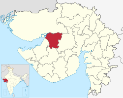 Location in Gujarat | |
| Coordinates: 22°49′28″N70°56′12″E / 22.82448846°N 70.93666165°E | |
| Country | |
| State | Gujarat |
| Region | Saurashtra |
| Established | 15 August 2013 |
| Headquarters | Morbi |
| Area | |
• Total | 4,872 km2 (1,881 sq mi) |
| Population (2011) | |
• Total | 960,329 |
| • Density | 197.1/km2 (510.5/sq mi) |
| Languages | |
| • Official | Gujarati, Hindi |
| Time zone | UTC+5:30 (IST) |
| Vehicle registration | GJ-36 |
| Website | morbi |
Morbi district is in the state of Gujarat, India. It was formed on 15 August 2013, along with several other districts, on the 67th Independence Day of India. [1] [2] Morbi city is the administrative headquarters of the district. The district has five talukas - Morbi, Maliya, Tankara, Wankaner (previously in Rajkot district) and Halvad (previously in Surendranagar district). Morbi city is the administrative headquarters of Morbi district. The town of Morbi is situated on the Machchhu River, 35 km from the sea and 60 km from Rajkot. As per 2011 census data, the city had a population of 2,10,451 and average literacy rate of 83.64%.
Contents
This district is surrounded by Kutch district to the north, Surendranagar district to the east, Rajkot district to the south and Jamnagar district to the west.
