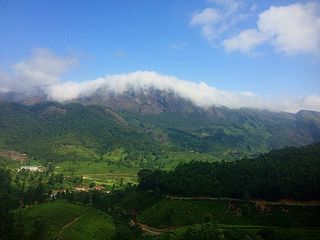
The Western Ghats or the Sahyadri Mountain range is a mountain range that covers an area of 160,000 km2 (62,000 sq mi) in a stretch of 1,600 km (990 mi) parallel to the western coast of the Indian peninsula, traversing the states of Gujarat, Maharashtra, Goa, Karnataka, Kerala and Tamil Nadu. It is a UNESCO World Heritage Site and is one of the eight biodiversity hotspots in the world. It is sometimes called the Great Escarpment of India. It contains a very large proportion of the country's flora and fauna, many of which are endemic to this region. According to UNESCO, the Western Ghats are older than the Himalayas. They influence Indian monsoon weather patterns by intercepting the rain-laden monsoon winds that sweep in from the south-west during late summer. The range runs north to south along the western edge of the Deccan Plateau and separates the plateau from a narrow coastal plain called Konkan along the Arabian Sea. A total of 39 areas in the Western Ghats, including national parks, wildlife sanctuaries and reserve forests, were designated as world heritage sites in 2012 – twenty in Kerala, ten in Karnataka, six in Tamil Nadu and four in Maharashtra.
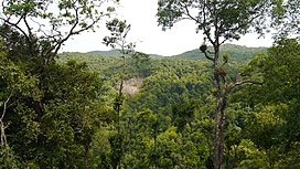
The South Western Ghats montane rain forests is an ecoregion in South India, covering the southern portion of the Western Ghats in Karnataka, Kerala and Tamil Nadu at elevations from 1,000 to 2,695 m. Annual rainfall in this ecoregion exceeds 2,800 mm (110 in).

The Malabar Coast moist forests are a tropical moist broadleaf forest ecoregion of southwestern India.

The South Western Ghats moist deciduous forests is an ecoregion in the Western Ghats of southern India with tropical and subtropical moist broadleaf forests. This biome covers the Nilgiri Hills between elevation of 250 and 1,000 m in Kerala, Karnataka and Tamil Nadu states.

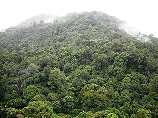
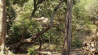
The North Western Ghats montane rain forests is a tropical moist broadleaf forest ecoregion of southwestern Indian peninsula. It covers an area of 30,900 square kilometers (11,900 sq mi), extending down the spine of the Western Ghauts range, from southernmost Gujarat through Damaon, Maharashtra, Goa& Karnataka. The montane rain forests are found above 1000 meters elevation, and are surrounded at lower elevations by the North Western Ghats moist deciduous forests.

The South Deccan Plateau dry deciduous forests is a tropical dry forest ecoregion in southern India. The ecoregion lies in the southernmost portion of the Deccan Plateau, and includes the southernmost portion of the Eastern Ghats.
The Khathiar–Gir dry deciduous forests is a mostly arid ecoregion in northwestern India that stretches over 103,100 sq mi (267,000 km2) across Gujarat, Rajasthan and Madhya Pradesh. The dry deciduous forests in the region are dominated by teak, and thorny trees and scrub in drier areas.
The term Malabar rainforests refers to one or more distinct ecoregions recognized by biogeographers:
- the Malabar Coast moist forests formerly occupied the coastal zone to the 250 metre elevation
- the South Western Ghats moist deciduous forests grow at intermediate elevations
- the South Western Ghats montane rain forests cover the areas above 1000 metres elevation

The Eastern Highlands moist deciduous forests, presently known as East Deccan moist deciduous forests, is a tropical and subtropical moist broadleaf forests ecoregion in east-central India. The ecoregion covers an area of 341,100 square kilometers (131,700 sq mi), extending across portions of Andhra Pradesh, Chhattisgarh, Jharkhand, Madhya Pradesh, Maharashtra, Odisha, and Telangana states.

The Northern dry deciduous forests, presently known as the North Deccan dry deciduous forests, is a tropical dry broadleaf forest ecoregion of east-central India.

The Narmada Valley dry deciduous forests are a tropical dry forest ecoregion of central India. The ecoregion lies mostly in Madhya Pradesh state, but extends into portions of Chhattisgarh, Maharashtra, Karnataka and Uttar Pradesh states.

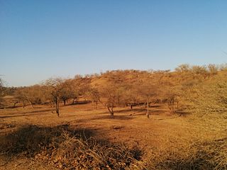
The Deccan thorn scrub forests are a xeric shrubland ecoregion of south India and northern Sri Lanka. Historically this area was covered by tropical dry deciduous forest, but this only remains in isolated fragments. The vegetation now consists of mainly of southern tropical thorn scrub type forests. These consist of open woodland with thorny trees with short trunks and low, branching crowns; spiny and xerophytic shrubs; and dry grassland. This is the habitat of the great Indian bustard and blackbuck, though these and other animals are declining in numbers; this area was at one time home to large numbers of elephants and tigers. Almost 350 species of bird have been recorded here. The remaining natural habitat is threatened by overgrazing and invasive weeds, but there are a number of small protected areas which provide a haven for the wildlife. Trees in these forests have adapted to not require much water.
The Central Deccan Plateau dry deciduous forests in Western and Southern India, containing large protected areas of natural tiger habitat.

The Geography of South India comprises the diverse topological and climatic patterns of South India. South India is a peninsula in the shape of a vast inverted triangle, bounded on the west by the Arabian Sea, on the east by the Bay of Bengal and on the north by the Vindhya and Satpura ranges.
Sahyadri Tiger Reserve is a reserve in the state of Maharashtra, created by the Indian government in 2008. Located in the Sahyadri Ranges of the Western Ghats of Maharashtra, it is part of the ecoregions of North Western Ghats moist deciduous forests and North Western Ghats montane rain forests. These ranges form a common boundary between Maharashtra, Karnataka and Goa, and constitute rich evergreen, semi-evergreen and moist deciduous forests. The area is spread over the four districts of Satara, Sangli, Kolhapur and Ratnagiri.
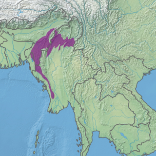
The Mizoram–Manipur–Kachin rain forests is a subtropical moist broadleaf forest ecoregion which occupies the lower hillsides of the mountainous border region joining India, Bangladesh, and Burma (Myanmar). The ecoregion covers an area of 135,600 square kilometres (52,400 sq mi). Located where the biotas of the Indian Subcontinent and Indochina meet, and in the transition between subtropical and tropical regions of Asia, the Mizoram–Manipur–Kachin rain forests are home to great biodiversity. The WWF rates the ecoregion as "Globally Outstanding" in biological distinctiveness.

The Tenasserim–South Thailand semi-evergreen rain forests are a tropical moist forest ecoregion in Southeast Asia. The ecoregion extends north–south along the Kra Isthmus. It includes lowland forests along the coasts, and montane forests in the Tenasserim Hills and Bilauktaung range, which form the mountainous spine of the isthmus.
Shoolpaneshwar Wildlife Sanctuary is a protected area in India's Gujarat state, located in the western Satpura Range south of the Narmada River and is 607.7 km2 (234.6 sq mi) large. It shares a common boundary with Madhya Pradesh and Maharashtra. It encompasses mixed dry deciduous forest, riverine forest, few pockets of moist teak forest, agricultural fields and two water reservoirs. It was established in 1982.

The Irrawaddy moist deciduous forests is a tropical moist broadleaf forest ecoregion in central Myanmar. The ecoregion occupies the central basin of the Irrawaddy River and the lower basin of the Salween River. The ecoregion is characterized by forests of tall trees which drop their leaves in the dry season. Most of the ecoregion's forests have been converted to agriculture.