Dewas district

Last updated

Dewas district
0102521 Siddhanath temple, Siddheshwar Mahadev temple, Nemawar, Madhya Pradesh 036.jpg
Siddheshwar Mahadev Temple, Nemawar
MP Dewas district map.svg
Location of Dewas district in Madhya Pradesh
Coordinates(Dewas): 22°57′36″N76°03′00″E / 22.96000°N 76.05000°E / 22.96000; 76.05000
CountryFlag of India.svg  India
State Madhya Pradesh
Division Ujjain
Headquarters Dewas
Tehsils 8 (Sonkatch, Dewas, Bagli, Kannod, Tonk Khurd, Khategaon, Hatpipliya and Satwas)
Area
  Total7,020 km2 (2,710 sq mi)
Population
 (2011) [1]
  Total1,563,715
  Density220/km2 (580/sq mi)
Demographics
[1]
  Literacy70.53%
  Sex ratio943:1000
Time zone UTC+05:30 (IST)
Vehicle registration MP 41 [2]
Lok Sabha constituency Dewas
Vidhan Sabha constituencies 5 (Dewas, Sonkatch, Hatpipliya, Bagli and Khategaon)
Website dewas.nic.in

Dewas District is a district in the Indian state of Madhya Pradesh. The town of Dewas is the district headquarters. It belongs to Ujjain Division.

Contents

Dewas District roughly corresponds to the territories of the twin Maratha princely states of Dewas - Junior & Senior. The district straddles the Vindhya Range; the northern portion of the district lies on the Malwa plateau, while the southern portion lies in the valley of the Narmada River. The Narmada forms the southern boundary of the district. The district is bounded to the east by Sehore District, to the south by the Harda and Khandwa districts, to the west by the Khargone and Indore districts, and to the north by the Ujjain and Shajapur districts. Dewas District is part of Ujjain Division. Devsaal Rawats of Uttarakhand are said to have their origins in Dewas at the time of legendary king Vikramāditya. [3] Dewas is about 152 kilometres (94 mi) from Bhopal and 40 kilometres (25 mi) from Indore by road.

Etymology

The district takes its name from the district headquarters town, Dewas, which is said to have been derived on the basis of two traditions. One is that Dewas lies at the base of a 300-foot (91 m) conical hill, known as Chamunda hill, on top of which the shrine of Chamunda is located. The image of the goddess is cut into the wall of a cave, known as Devi Vashini or the goddess's residence. From this, the name Dewas (dev-vas) seems to have been derived. The other view of the probable origin is from the name of the founder of the city, Dewasa Bania. [4]

History

Dewas was formerly two separate Maratha princely states of British India (Dewas Junior) and (Dewas Senior). The original state was founded in the first half of the 18th century by the brothers - Jivaji Rao (Junior) and Tukaji Rao (Senior), from the Puar clan of Marathas. They had advanced into Malwa with the Maratha Peshwa, Baji Rao, in 1728. The brothers divided the territory among themselves and their descendants ruled as the senior and junior branches of the family. After 1841, each branch ruled its own portion as a separate state, though the lands belonging to each were intimately entangled. Both Dewas States were in the Malwa Agency of the Central India Agency.

Dewas Junior & Senior Darbars (Courts) were composed of Sardars, Mankaris, Istamuradars, Thakurs and Jagirdars. [5] [6]

After India's independence in 1947, the Rajas of Dewas acceded to India, and their states were integrated into Madhya Bharat, which became a state of India in 1950. Later, in 1956, Madhya Bharat was merged into Madhya Pradesh state. [7]

Geography

Dewas district lies in west Madhya Pradesh on the level plains of the Malwa plateau. To the south, the land rises gently to the Vindhya Range, which is the source of the Chambal and Kali Sindh rivers that flow north through the district on their way to the Ganges.

Climate

Due of its high elevation and inland location, even during the hottest months of the year, the nights are relatively cool, which is known as Shab-e-Malwa . [8] Three distinct seasons are observed: summer, monsoon and winter. Dewas gets most of its rainfall during July–September due to the southwest monsoon.

MonthJanFebMarAprMayJunJulAugSepOctNovDecYear
Record high °C (°F)26.5
(79.7)
29.3
(84.7)
34
(93)
38.1
(100.6)
40.4
(104.7)
36.3
(97.3)
29.7
(85.5)
28.5
(83.3)
29.7
(85.5)
31.7
(89.1)
29.3
(84.7)
27.1
(80.8)
40.4
(104.7)
Daily mean °C (°F)18.3
(64.9)
20.5
(68.9)
25.1
(77.2)
29.7
(85.5)
33
(91)
30.6
(87.1)
26.3
(79.3)
25.4
(77.7)
25.6
(78.1)
24.7
(76.5)
21
(70)
18.7
(65.7)
24.9
(76.8)
Record low °C (°F)10.2
(50.4)
11.8
(53.2)
16.2
(61.2)
21.3
(70.3)
25.6
(78.1)
24.9
(76.8)
22.9
(73.2)
22.3
(72.1)
21.5
(70.7)
17.7
(63.9)
12.7
(54.9)
10.4
(50.7)
10.2
(50.4)
Average rainfall mm (inches)9
(0.4)
2
(0.1)
7
(0.3)
3
(0.1)
7
(0.3)
122
(4.8)
327
(12.9)
274
(10.8)
240
(9.4)
30
(1.2)
13
(0.5)
5
(0.2)
1,039
(41)
Source: climate-data.org [9]

Places of interest

Pushpgiri Tirth, Sonkatch, Dewas Pushpgiri Tirth, Sonkatch, Dewas.png
Pushpgiri Tirth, Sonkatch, Dewas
Pushpgiri Jain Tirth, Sonkatch, Dewas Pushpgiri Jain Tirth, Sonkatch, Dewas.png
Pushpgiri Jain Tirth, Sonkatch, Dewas

Pushpgiri Tirth, Sonkatch

Shri Digambar Jain Teerth Kshetra, Pushpagiri is located 4 km (2.5 mi) west of Sonkatch, in the area of the Songiri Hills. [10] [11] The temple here is dedicated to Lord Mahavir. This Jain kshetra is a sprawling 250-acre complex housing Jain Sthanaks, schools, hospital, museum, cottages, shopping center and a 108-foot-tall (33 m) idol of Bhagwan Paraswanath in a Yogic (Padmasan) posture, one of the tallest Jain idols.

Kheoni wildlife Sanctuary

Kheoni Wildlife Sanctuary Area, Dewas Kheoni Wildlife Sanctuary Area, Dewas.png
Kheoni Wildlife Sanctuary Area, Dewas

Kheoni Wildlife Sanctuary straddles Kannod tehsil of Dewas district and Sehore district [12] It is spread over an area of 132 square kilometres (51 sq mi). According to a bird survey done in April 2018, Kheoni has around 125 species of birds, including the state bird of Madhya Pradesh, the Indian paradise flycatcher. [13]

Kheoni Wildlife Sanctuary, Dewas Kheoni Wildlife Sanctuary, Dewas.png
Kheoni Wildlife Sanctuary, Dewas

Kavadia Hills

Basaltic columns at Kavadia hills Interlocked basaltic columns at of Kavadia mountain.jpg
Basaltic columns at Kavadia hills

These are a series of hills, situated next to Potla and Pipri villages in Bagli Taluk of Dewas district. [14] There are a total of seven mountain-like formations of shaped, interlocking, basalt columns that were probably created simultaneously as a result of volcanic eruption millions of years ago. These rock columns are arranged in a pattern that gives an appearance of a man-made structure. Most of the columns are hexagonal and interlocked with similar rocks on all the edges that emit a musical sound when struck. [15] Most visible columns are 8 to 10 feet long but there can be longer rocks further deep inside the mountain. Although basalt columns are not unique and are found at several places around the world (including St. Mary's Islands in Karnataka, India), the quality, quantity, geometrical arrangement and location (far from an ocean) of this place is unique. [16]

Gidya Khoh

Situated on the Indore-Nemawar road, Gidya Khoh or Gidiya Khoh lies in the Dewas District, and has a waterfall surrounded by a valley. The waterfall cascades from a height of 500–600 ft. Khudel devta temple is located here. Gidya Khoh is located about 48 kilometres (30 mi) south of Dewas and 42 km east of Indore. [17]

Other

Dewas' water management programs

The United Nations awarded Dewas district's community water management works the 3rd place under the category of "Best Water Management Practices" for 2011–2012. [18] The United Nations also praised Bhagirath Krishhak Abhiyan of Dewas district, started by district administrator Umakant Umrao. [18] A documentary film made by Public Service Broadcasting Trust about Dewas water revolution was featured on Lok Sabha TV. [19]

Divisions

Tehsils of Dewas district Dewas Tehsil Locator.png
Tehsils of Dewas district

Dewas District is divided into eight tehsils:

  1. Sonkatch,
  2. Dewas,
  3. Bagli,
  4. Kannod,
  5. Tonk Khurd,
  6. Khategaon,
  7. Hatpipliya
  8. Satwas.

Dewas tehsil is situated on the north-western part of the district, Sonkatch on the north-eastern part, Bagli on the south, Kannod on the south-central part and Khategaon on the South-east. Dewas, the headquarters of Dewas tehsil, and the district headquarters, is situated on National Highway and is also connected by broad-gauge railway line of western Railway. [20]

The district contributes 5 seats to the Madhya Pradesh Vidhan Sabha: Dewas, Sonkatch, Hatpipliya, Bagli and Khategaon.

Dewas is also spread across 3 Lok Sabha constituencies: Dewas (Sonkatch, Dewas, Tonk Khurd and Hatpipliya tehsils), Khandwa (Bagli and Satwas tehsils) and Vidisha (Khategoan and Kannod tehsils)

Transport

In terms of roadways, NH-47 passes through the southern parts of the district and NH-52 passes through Dewas city. In addition, there are State Highways and other district highways within the district. The district has 3 railway stations, of which Dewas Junction (DWX), gets the most passenger traffic. It is a part of Ratlam Division of the Western Railway Zone.

Demographics

Historical population
YearPop.±% p.a.
1901228,938    
1911274,986+1.85%
1921268,396−0.24%
1931306,975+1.35%
1941326,221+0.61%
1951345,306+0.57%
YearPop.±% p.a.
1961446,901+2.61%
1971594,336+2.89%
1981795,309+2.96%
19911,033,807+2.66%
20011,308,223+2.38%
20111,563,715+1.80%
source: [21]

According to the 2011 census Dewas District has a population of 1,563,715, [1] roughly equal to the nation of Gabon [22] or the US state of Hawaii. [23] This gives it a ranking of 319th in India (out of a total of 640). [1] The district has a population density of 223 inhabitants per square kilometre (580/sq mi). [1] Its population growth rate over the decade 2001-2011 was 19.48%. [1] Dewas has a sex ratio of 941 females for every 1000 males, [1] and a literacy rate of 70.53%. 28.89% of the population lives in urban areas. Scheduled Castes and Scheduled Tribes make up 18.67% and 17.44% of the population respectively. [1]

Languages

Languages of Dewas district (2011) [24]

   Hindi (55.51%)
   Malvi (32.73%)
   Nimadi (3.10%)
   Urdu (1.90%)
   Gondi (1.31%)
   Bareli (1.08%)
   Bhili (0.91%)
  Others (3.46%)

As of the 2011 census, 55.51% of the population in the district spoke Hindi, 32.73% Malvi, 3.10% Nimadi, 1.90% Urdu, 1.31% Gondi, 1.08% Bareli, and 0.91% Bhili as their first language. [24]

Related Research Articles

<span class="mw-page-title-main">Madhya Pradesh</span> State in central India

Madhya Pradesh is a state in central India. Its capital is Bhopal, and the largest city is Indore, with Gwalior, Jabalpur, Ujjain, Dewas, Sagar, Satna, and Rewa being the other major cities. Madhya Pradesh is the second largest Indian state by area and the fifth largest state by population with over 72 million residents. It borders the states of Uttar Pradesh to the northeast, Chhattisgarh to the east, Maharashtra to the south, Gujarat to the west, and Rajasthan to the northwest.

<span class="mw-page-title-main">Indore</span> Metropolitan Tier 2 city in Madhya Pradesh, India

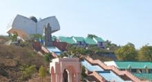
Indore is the largest and most populous city in the Indian state of Madhya Pradesh. It is consistently ranked as the cleanest city in India. It serves as the headquarters of both the Indore District and the Indore Division. It is also considered as the state education hub and houses campuses of both the Indian Institute of Technology and the Indian Institute of Management. Located on the southern edge of Malwa Plateau, at an average altitude of 553 meters (1,814 ft) above sea level, it has the highest elevation among major cities of Central India. The city is 190 km (120 mi) west of the state capital of Bhopal. It is 57 km (35 mi) from Ujjain and 35 km (20 mi) from Dewas. Indore had a census-estimated 2011 population of 1,994,397 and 3,570,295. The city is distributed over a land area of just 530 square kilometres (200 sq mi), making Indore the most densely populated major city in the central province.

<span class="mw-page-title-main">Malwa</span> Place in India

Malwa is a historical region of west-central India occupying a plateau of volcanic origin. Geologically, the Malwa Plateau generally refers to the volcanic upland north of the Vindhya Range. Politically and administratively, it is also synonymous with the former state of Madhya Bharat which was later merged with Madhya Pradesh. At present the historical Malwa region includes districts of western Madhya Pradesh and parts of south-eastern Rajasthan. Sometimes the definition of Malwa is extended to include the Nimar region south of the Vindhyas.

<span class="mw-page-title-main">Ujjain</span> City in Madhya Pradesh, India

Ujjain or Ujjayinī is a city in Ujjain district of the Indian state of Madhya Pradesh. It is the fifth-largest city in Madhya Pradesh by population and is the administrative centre of Ujjain district and Ujjain division. It is one of the Hindu pilgrimage centres of Sapta Puri famous for the Kumbh Mela (Simhastha) held there every 12 years. The famous temple of Mahakaleshwar Jyotirlinga is located in the center of the city. The city has been one of the most prominent trade and political centres of the Indian Subcontinent from the time of the ancient Mahājanapadas until the British colonisation of India.

<span class="mw-page-title-main">Dewas</span> City in Madhya Pradesh, India

Dewas is a city in the Malwa region of the Indian state of Madhya Pradesh. The municipality was formerly the seat of two 15-Gun Salute state princely states during the British Raj, Dewas Junior state and Dewas Senior state, ruled by the Pawar clan of the Marathas. The city is the administrative capital of Dewas district. Dewas is an industrialised city and houses a government bank note press.

<span class="mw-page-title-main">Jaora</span> City in Madhya Pradesh, India

Jaora is a city and a municipality in Ratlam district in the Indian state of Madhya Pradesh. Jaora is located in the Malwa region, between Ratlam and Mandsaur. It was the capital of the Jaora princely state of Jaora before Independence. During the Mourning of Muharram, thousands of people from all over the world visit the shrine of Hussain Tekri. Jains visit Jaora as a place that the Jain ascetic Rajendrasuri practiced tapasya.

<span class="mw-page-title-main">Kali Sindh River</span> River in India

The Kali Sindh (Krashna Sindhu), is a river in Madhya Pradesh and Rajasthan in northern India. It is a tributary of the Chambal River in the Ganges Basin. The main tributaries of the Kali Sindh are the Parwan, Niwaj and Ahu rivers. The Kali Sindh River drains a major portion of the Malwa region, and is the biggest river flowing in the Malwa region of Madhya Pradesh.

Kanad is a town and a nagar parishad in Agar Malwa district in the Indian state of Madhya Pradesh. It comes under Kanad Parishad. It belongs to Ujjain Division. It is situated along the Agar–Sarangpur SH-41 highway. It is located 18 km (11 mi) towards east from the district headquarters of Agar Malwa, 83 km (52 mi) from Ujjain, 186 km (116 mi) from the state capital of Bhopal.

<span class="mw-page-title-main">Rajgarh district</span> District of Madhya Pradesh in India

Rajgarh district is a district of Madhya Pradesh in central India. The city of Rajgarh is the administrative headquarters of the district. The old name of Rajgarh was Jhanjhanipur. Rajgarh in Madhya Pradesh is one of the aspirational districts selected by Government of India. The district has an area of 6,154 km² and the population is 1,545,814. The district lies on the northern edge of the Malwa plateau, and the Parbati River forms the eastern boundary of the district, while the Kali Sindh River forms the western boundary. The district has seven tehsils, Rajgarh, Khilchipur, Jirapur, Biaora, Narsinghgarh, Sarangpur and Pachore. The district is bounded by Rajasthan state to the north, and by the districts of Guna to the northeast, Bhopal to the east, Sehore to the southeast, and Shajapur to the south and west. It is part of Bhopal Division. There are 1728 villages in Rajgarh.

<span class="mw-page-title-main">Ujjain district</span> District of Madhya Pradesh in India

Ujjain district is a district of Madhya Pradesh state in central India. The historic city of Ujjain is the district headquarters. The district has an area of 6,091 km2, and a population of 19,86,864, a 16.12% increase from its 2001 population of 17,10,982.

<span class="mw-page-title-main">Indore district</span> District of Madhya Pradesh, India

The Indore District is a district of Madhya Pradesh state in central India. It is believed that the city is named after its Indreshwar Mahadev Temple, Where Indra is the presiding deity. The Gupta inscriptions name Indore as "Indrapura". It is also called the administrative capital. This district forms part of the Indore Division.

<span class="mw-page-title-main">Badnagar</span> Tehsil in Madhya Pradesh, India

Badnagar is a town, and a municipality in Ujjain district in the state of Madhya Pradesh, India. Badnagar Tehsil Headquarters is Badnagar town and it belongs to Ujjain Division. It is located 45 km towards west from District headquarters Ujjain. 244 km from the state capital, Bhopal, towards the east and 72 km from Indore.

Badnawar (or Badnavar) is a Town, former pargana and a Nagar Parishad of the Dhar district in the state of Madhya Pradesh, India. This is a tehsil place having 170 villages. Badnawar is around 95 km from Indore - the business capital of Madhya Pradesh.

Satwas is a town and a Nagar Panchayat in Dewas district in the Indian state of Madhya Pradesh. Satwas is around 136.8 km (85.0 mi) from Dewas.

Sonkatch is a town and a Nagar panchayat in Dewas district in the Indian state of Madhya Pradesh.

Bagli is a town and a nagar panchayat in the Malwa region of Dewas district in the state of Madhya Pradesh, India. Bagli is around 66 km (41 mi) from Dewas.

<span class="mw-page-title-main">Nemawar</span> Village in Madhya Pradesh, India

Nemawar is a small town in Dewas District, Madhya Pradesh, India. Nemawar is located on the left bank of the Narmada river opposite to Handia. However, it belongs to Khategaon block and tehsil of the Dewas district

<span class="mw-page-title-main">Rao Nandlal Chaudhary</span>

Rao Nandlal Chaudhary was the chief of the Zamindars of Kampel, near Indore. He was a Gaur Brahmin. Under the suzerainty of the Mughals, he controlled Kampel and some of its surrounding area including Indore. He accepted the suzerainty of the Marathas, after the Nizam acceded to the Peshwa's demands in 1724.

<span class="mw-page-title-main">Dewas State</span> 1728–1948 territory of two Maratha princely states in India

Dewas State was a territory within Central India, which was the seat of two Maratha princely states during the British Raj. After the Maratha conquest of Central India, Dewas was divided into two states - Dewas Junior ruled by Jivaji Rao Puar and Dewas Senior ruled by Tukoji Rao Puar. On 12 December 1818, the 2 Dewas States became British protectorates.

<span class="mw-page-title-main">Kheoni Wildlife Sanctuary</span> Wildlife sanctuary in Madhya Pradesh, India

Kheoni is a wildlife sanctuary located in Kannod Tehsil of Dewas district and parts of Sehore district of Madhya Pradesh. It is spread over an area of 132 square kilometers. It is connected to Ratapani Tiger Reserve through corridors. The dry deciduous forest consists of teak, tendu and bamboo.

References

  1. 1 2 3 4 5 6 7 8 "District Census Handbook: Dewas" (PDF). Census of India . Registrar General and Census Commissioner of India. 2011.
  2. "MP 41 Dewas city Regional Transport Office (RTO) in Madhya pradesh". rtocode.com. Retrieved 13 January 2021.
  3. "Home: Welcome to Official Website of Dewas District Collectorate". dic.mp.nic.in. Archived from the original on 16 June 2014.
  4. "Geography". dic.mp.nic.in. Retrieved 30 September 2016.
  5. Madan, T.N. (1988). Way of Life: King, Householder, Renouncer : Essays in Honour of Louis Dumont. Motilal Banarsidass. p. 129. ISBN   9788120805279 . Retrieved 4 July 2015.
  6. Russell, Robert Vane (1916). "Pt. II. Descriptive articles on the principal castes and tribes of the Central Provinces".
  7. "History Of Dewas". dic.mp.nic.in. Retrieved 30 September 2016.
  8. Omkareshwar and Maheshwar: Travel Guide. Goodearth Publications. 2011. p. 79. ISBN   9789380262246. Archived from the original on 8 October 2017. Retrieved 8 October 2017.
  9. "Dewas climate: Average Temperature, weather by month, Dewas weather averages - Climate-Data.org" . Retrieved 17 December 2020.
  10. "Pushpgiri Teerth, Sonkutch, Dist. Dewas (M.P.), India". Archived from the original on 21 August 2016. Retrieved 12 July 2016.
  11. "Shri Pushpgiri Ji, Sonkatch, Dewas" . Retrieved 13 July 2021.
  12. "Kheoni Wildlife Sanctuary". WildTrails Recent Sightings. 23 September 2017.
  13. "Four new species found in first Malwa bird count". The Times of India. 9 April 2018.
  14. "Kavadia Hills" . Retrieved 13 July 2021.
  15. "Dewas Tourism, Famous Tourist Spots in Dewas, Travel in Dewas". www.dewasonline.in.
  16. "Madhya Pradesh: Rare rock formation found in Dewas district". The Times of India. 24 December 2018. Retrieved 28 December 2020.
  17. "Gidiya Kho" . Retrieved 13 July 2021.
  18. 1 2 "'Water for Life' UN-Water Best Practices Award: 2012 edition: Finalists" . Retrieved 21 May 2015. 3rd ranked: Bhagirath Krishhak Abhiyan, Water Conservation for Food Security
  19. "Umakant Umrao "Dewas Ke Bhagirath"". YouTube . Archived from the original on 21 December 2021. Retrieved 21 May 2015.
  20. "Dewas - General Information" . Retrieved 13 July 2021.
  21. "Decadal Variation In Population Since 1901". www.censusindia.gov.in. Office of the Registrar General & Census Commissioner, India.
  22. US Directorate of Intelligence. "Country Comparison:Population". Archived from the original on 13 June 2007. Retrieved 1 October 2011. Gabon 1,576,665
  23. "2010 Resident Population Data". U. S. Census Bureau. Archived from the original on 19 October 2013. Retrieved 30 September 2011. Hawaii 1,360,301
  24. 1 2 "Table C-16 Population by Mother Tongue: Madhya Pradesh". censusindia.gov.in. Registrar General and Census Commissioner of India.