Umaria district

Last updated
Umaria district
Waterfall on Johilla river, Umaria dist, Madhya Pradesh, India.jpg
1 Bandhavgarh National Park Madhya Pradesh India.jpg
Top: Waterfall on the Johilla River
Bottom: Bandhavgarh National Park
MP Umaria district map.svg
Location of Umaria district in Madhya Pradesh
Coordinates(Umaria): 23°31′37″N80°50′17″E / 23.527°N 80.838°E / 23.527; 80.838
CountryIndia
State Madhya Pradesh
Division Shahdol
Headquarters Umaria
Area
  Total4,548 km2 (1,756 sq mi)
Population
 (2011)
  Total644,758
  Density140/km2 (370/sq mi)
Demographics
   Literacy 67.34 per cent
  Sex ratio953
Time zone UTC+05:30 (IST)
Website umaria.nic.in

Umaria district is a district of Madhya Pradesh. The town of Umaria is the district headquarters. The district is part of Shahdol Division.

Contents

The total geographical area of the district sums up to 4548 square kilometers and has a population of 644,758. Umaria is enriched with its vast resources of forests and minerals. The coal mines are a steady source of revenue for the district.

The most important mineral found in the district is coal and as a result 8 mines are being operated by South Eastern Coalfields Limited (Nowrozabad) in the district. The Bandhavgarh National Park (Tala) and Sanjay Gandhi Thermal Power Station at Mangthar (Pali) are located in the district. Umaria was formerly the headquarters of the South Rewa District and thereafter the headquarters town of the Bandhavgarh tehsil. It is situated at a distance of about 69 km. from Shahdol, the parent district. Metalled roads connect the town with Katni, Rewa, Shahdol, etc., on which regular buses ply. Umaria is also a railway station on the Katni-Bilaspur section of the South East Central Railway zone.

As of 2011 it is the second least populous district of Madhya Pradesh (out of 50), after Harda.

History

Umaria was ruled by Lodhi Rajputs. The Lodhi Rajput family built the temple of Lakshmi Narayan on southern bank of Narbada Barman ghat. They also built on the steps of the northern bank of Barman ghat Karkeli a great gateway called the Hathi Darwaza, to allow their elephants passage. The fort of Bandhavgarh was given as dowry with Padamkuwari, daughter of Somdutt Karchuli of Mandla to Karan Deo, son of Maharaja Vyaghradev. Bandhogarh was the early capital of the Baghel dynasty. Akbar spent his childhood days in Bandhogarh.

Later the Baghels of Rewa came with his force and won Umaria from Lodhis. Umaria was always a favourite town for many princes and kings because the dense forests and tigers. It was the southern capital of old Rewa District under the former Bandhogarh tehsil. The forests of Bandhavgarh were a game reserve of Maharaja of Rewa.

After independence, Umaria was a part of Shahdol district. In 1998, it was carved out of Shahdol as a separate district.

Climate

Average Rainfall : 1293 m.m.

Average Max. Temperature :46.2 °C

Average Min. Temperature : -0.1 °C

Economy

Women working on road, Umaria district Women working on road repairing, Umaria district, Madhya Pradesh, India.jpg
Women working on road, Umaria district

In 2006 the Ministry of Panchayati Raj named Umaria one of the country's 250 most backward districts (out of a total of 640). [1] It is one of the 24 districts in Madhya Pradesh currently receiving funds from the Backward Regions Grant Fund Programme (BRGF). [1]

Demographics

Historical population
YearPop.±% p.a.
190194,216    
1911107,749+1.35%
1921100,086−0.74%
1931120,599+1.88%
1941137,759+1.34%
1951150,720+0.90%
1961201,898+2.97%
1971242,341+1.84%
1981319,231+2.79%
1991420,815+2.80%
2001515,963+2.06%
2011644,758+2.25%
source: [2]

According to the 2011 census Umaria District has a population of 644,758, [3] roughly equal to the nation of Montenegro [4] or the US state of Vermont. [5] This gives it a ranking of 513th in India (out of a total of 640). The district has a population density of 158 inhabitants per square kilometre (410/sq mi). Its population growth rate over the decade 2001-2011 was 24.73%. Umaria has a sex ratio of 953 females for every 1000 males, and a literacy rate of 67.34%. 17.15% of the population lives in urban areas. Scheduled Castes and Scheduled Tribes made up 9.02% and 46.64% of the population respectively. The Gonds make up the largest tribal group, accounting for 40% of the total ST population. Other important tribes include the Baigas and Kols.[ citation needed ]

Religions in Umaria district (2011) [6]
ReligionPercent
Hinduism
96.33%
Islam
2.48%
Other (tribal religion)
0.93%
Other or not stated
0.26%

Hindus are the largest group in the district with 96.33%. Muslims are 2.48% and traditional tribal religions were 0.93%. [6]

Languages

Languages of Umaria district (2011) [7]

   Hindi (83.58%)
   Bagheli (14.43%)
   Gondi (0.94%)
  Others (1.05%)

At the time of the 2011 Census of India, 83.58% of the population in the district spoke Hindi, 14.43% Bagheli and 0.94% Gondi as their first language. [7]

Bandhavgarh National Park

Bandhavgarh (The ancient Name is Bandhogarh[ citation needed ]) is a relatively small park. In the last few years this former game reserve has become one of India's most prominent National Parks. The major reason for all the interest is Bandhavgarh high density of tigers, which roam the mixed forests of sal, bamboo and ambilica officinale in search of an easy kill. The tigers have not only bolstered the local population by breeding successfully, they have also brought international media attention to the park and to the plight of the Royal Bengal Tiger. The density of the tiger population at Bandhavgarh is the highest known in India. 60 Tigers at 450 km2 area in Bandhavgarh National Park. This is also white tiger country. The last known as captured by Maharaja Martand Singh in 1951. This white tiger, named "Mohan," is now stuffed and display in the place of Maharaja of Rewa.[ citation needed ]

Attractions

Bandhavgarh Fort

Bandhavgarh is the name of tehsil in Umaria District. Formerly it was the capital of the Bandhavgarh Kingdom of the Magha dynasty, then the headquarters of the tehsil. At present its headquarters is Umaria.

The fort of Bandhavgarh is a place of considerable archaeological and historical importance.

It is a natural impregnable fort and stands on a hill, at an attitude of about 2,430 m (7,970 ft) above sea-level. The Bamnia hill is also a part of the fort, because it is enclosed by a rampart. The fort is on the Rewa-Uma-Katni road at a distance of about 41 km (25 mi) from Umaria Town.


Nowrozabad

Naurozabad city (Johila area) is enriched by the coal deposits found in the area. Coal industrial sector has developed in this area due to the proximity of coal mines. The most prestigious government undertaking and the largest coal producing industry in India, South Eastern Coalfields Limited is located in this area. Nowrozabad is one of the 13 administrative regions of the coal industry. It is the head office of Johila region. The major employment source in the city is the coal mines of the South Eastern Coal Fields Limited. This is a city situated on the banks of the Johila river.

Chandia

Chandia is on the Umaria-Katni road, 21 km (13 mi) from Umaria. The railway station of Chandia Road, known as Chandia railway station.

The most important spot of Chandia is a small temple, enshrining Goddess Kalika. Her mouth is wide open, but her out-stretched tongue is broken. There is also an old temple of god Rama and his consort Janaki. It was a thikana (state or estate) of Thakur of Chandia. A small fair meets at Suraswahi Chandia for three days in February/March, on the occasion of Shivaratri. There is a Fort Chandia of Baghels.

Pali Birsinghpur

Pali Birsinghpur is situated on the Umaria-Shahdol road, at a distance of about 36 km (22 mi) from Umaria. Another road goes from Pali to Mandla via Dindori. This place is famous for Maa Birasini Devi Temple. Pali is also a railway station, and there is a rest house for the tourists to stay. The station is known as the Pali-Birsinghpur station. Near the railway station there is a temple, enshrining Maa Birasini Devi Temple. By popular belief she is Goddess Kali, represented here as skeleton Goddess, but with her mouth closed. Many remains of old Jain idols kept here in some Hindu temples. The annual fairs are held both in October and March, on the occasion of Navaratri, near the temple of Goddess.

Umaria town

The headquarters town of the Umaria district and Bandhavgarh tehsil, formerly Umaria was the headquarters of the South Rewa District. It is situated at a distance of about 69 km (43 mi) from Shahdol.

Near the railway station stands a Shiva temple, known as the Sagara temple. It was an old shrine, recently remodeled. Its main gates are still intact with stone statues, carved in Khajuraho models. Near about is Jwalamukhi temple. About 6.5 km (4.0 mi) from the town, there is another temple named Madhibag temple of Mahabharata era, with similar carvings of the Khajuraho pattern.

Umaria is known for its coal-mines, which were opened in 1881 by the Government of India and transferred to the Rewa Darbar in the same year, mainly to meet the requirement of railway at Katni.

Baderi

Baderi is a gram panchayat in Umaria district. It is situated about 5 km (3.1 mi) from Umaria in Bandhavgarh Road.

It was an estate under Rewah Riyasat. It was ruled by Baghela rajputs. There is Nand Mahal and Baderi Fort, dates back to 17th century. Nand Mahal was built by the Baghela chief, Lal Ahlad Singh in 1750s and Baderi Fort was half built by Lodhi rajputs, later on conquered and constructed by Lal Ramnat Singh in 1850s.

Manpur

Manpur is a block and the biggest tehsil in umaria district. It is situated about 45 km (28 mi) from district headquarter and about 12 km (7.5 mi) from Bandhavgarh National Park in Tala-Jaisinghnagar road. There are 84 Gram Panchayats in Manpur tehsil.

Mangthar Dam (Birsinghpur Reservoir)

Birsinghpur Reservoir is located 12–13 km (7.5–8.1 mi) from Birsinghpur Pali Railway Station. This reservoir is constructed for Sanjay Gandhi Thermal Power Station. This reservoir is constructed on Johila river, which originates near Amarkantak in Anuppur district of Madhya Pradesh. Johila River is a tributary of the Son River, which is the second largest tributary of the Ganga river from the southern banks.

Related Research Articles

<span class="mw-page-title-main">Satpura Range</span> Hill range in central India

The Satpura Range is a range of hills in central India. The range rises in eastern Gujarat running east through the border of Maharashtra and Madhya Pradesh and ends in Chhattisgarh. The range parallels the Vindhya Range to the north, and these two east–west ranges divide Indian Subcontinent into the Indo-Gangetic plain of northern India and the Deccan Plateau of the south. The Narmada River originates from north-eastern end of Satpura in Amarkantak, and runs in the depression between the Satpura and Vindhya ranges, draining the northern slope of the Satpura range, running west towards the Arabian Sea. The Tapti River originates in the eastern-central part of Satpura, crossing the range in the center and running west at the range's southern slopes before meeting the Arabian Sea at Surat, draining the central and southern slopes of the range. Multai, the place of Tapi river origin is located about 465 kilometer far, south-westerly to Amarkantak, separated across by the hill range. The Godavari River and its tributaries drain the Deccan plateau, which lies south of the range, and the Mahanadi River drains the easternmost portion of the range. The Godavari and Mahanadi rivers flow into the Bay of Bengal. At its eastern end, the Satpura range meets the hills of the Chotanagpur Plateau. The Satpura Range is a horst mountain and is flanked by Narmada Graben in the north and much smaller but parallel Tapi Graben in the south.

<span class="mw-page-title-main">Rewa, Madhya Pradesh</span> City in Madhya Pradesh, India

Rewa is a city in the north-eastern part of Madhya Pradesh state in India. It is the administrative center of Rewa District and Rewa Division. The city lies about 420 kilometres (261 mi) northeast of the state capital Bhopal and 230 kilometres (143 mi) north of the city of Jabalpur. The maximum length of Rewa district is 125 km from east to west and the length of Rewa from north to south is 96 km. This area is surrounded by Kaimur hills to the south Vindhyachal ranges pass through the middle of the district.

<span class="mw-page-title-main">Rewa district</span> City and district of Madhya Pradesh in India

Rewa district is a district of the Madhya Pradesh state in central India. The city of Rewa is the district headquarter. Rewa is sometimes called – 'Land of White Tigers' as the first White Tiger was discovered here in 1951 by Maharaja of the province, Martand Singh in the nearby jungle of Govindgarh. Rewa was the capital city of once a state – Vindhya Pradesh.

<span class="mw-page-title-main">Shahdol district</span> District of Madhya Pradesh in India

Shahdol District is a district of Madhya Pradesh state in east central India. It old name was Matsya raj or Virat kingdom in the name of great king Maharaja Virata. With a total area of 6,205 km2 (2,396 sq mi) and a population of 10,66,063. Shahdol is an important district of Madhya Pradesh. The town of Shahdol is the district headquarters. The district formerly comprised Shahdol division.

Satna is a city in the Indian state of Madhya Pradesh. It serves as the headquarters of Satna district. It is 7th largest city and 8th most populous city of the state. The city is 500 km east of the state capital Bhopal. The city is distributed over a land area of 111.9 square kilometres.

Bijuri is a town and a Municipality or Municipal Council or Nagar Palika Parishad in Anuppur district in the state of Madhya Pradesh, India.

Burhar is a town and nagar panchayat in Shahdol district in the state of Madhya Pradesh, India. Burhar was named after Budhi Mata, a local deity. It also has a temple belonging to her, in Purani Basti. Burhar is one of the fastest emerging commercial hubs of the division due to its geographical location.

Nowrozabad or Khodargama is a city and a Nagar Palika in Umaria district in the Indian state of Madhya Pradesh. Kendriya Vidyalaya Nowrozabad is situated in the G.M Complex Johilla area. Nowrozabad is the head office of Johilla area. The nearest Airport is at Jabalpur in Madhya pradesh. Nowrozabad Railway Station is on the Katni - Anuppur rail route. There are many coal mines around here. National Highway 43 has its route through Nowrozabad.

<span class="mw-page-title-main">Satna district</span> District of Madhya Pradesh in India

Satna District is a district of Madhya Pradesh state in central India. The city of Satna is the district headquarters. The district has an area of 7,502 km², and a population of 22,28,935(2011 census), 20.63% of which is urban. The district has a population density of 249 persons per km².

<span class="mw-page-title-main">Govindgarh, Madhya Pradesh</span> City in Madhya Pradesh, India

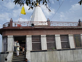
Govindgarh, the summer capital of Mahraja Rewa, is about 18 km from Rewa in Madhya Pradesh, India. The is Rewa, with an area of about 13,000 mi², was the largest princely state in the Bagelkhand Agency and the second largest in Central India Agency. The British political agent for Bagelkhand resided at Satna, on the East Indian railway. The Bagelkhand capital establish in Rewa under the Rewa Maharaja.Bagheli is the local language of the region.It's neighbouring towns are Manikawar, Gurh and Rewa.

Dindori, formerly known as Ramgarh, is a district head office and a nagar panchayat in Dindori district in the state of Madhya Pradesh, India. Dindori has many historical as well as spiritual places. Some of the spiritual places are Laxman Madva, Kukarramath, Kalchuri Kali Mandir etc. Kanha Tiger Reserve is 180 km & Bandhavgarh National Park is 140 Km away from the district headquarter.

Bahoriband is a Tehsil and a Gram panchayat in Katni district in the Indian state of Madhya Pradesh. Bahoriband Tehsil Headquarters is Bahoriband town. It belongs to Jabalpur Division. It is located 44 km towards west from District headquarters Katni. 320 km from State capital Bhopal towards west. Bahoriband Tehsil is bounded by Sihora Tehsil towards South, Majhouli Tehsil towards South, Rithi Tehsil towards North, Murwara Tehsil towards East. Jabalpur City, Umaria City, Katni City are the nearby cities to Bahoriband.

The Surguja Express is a daily express train of North Central Railway, in India, running between Gwalior City in Madhya Pradesh and Ambikapur town in Chhattisgarh.

Damoy village is located to the North East of Umaria district of Madhya Pradesh. The nearby villages are Indwar, Bharewa, Mugwani, Ashodh, Chandwar, Chinsura, Baturawah, Surtan, Bholgarh etc.

<span class="mw-page-title-main">Bhopal–Bilaspur Express</span> Train in India

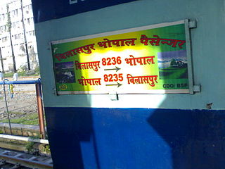
The Bhopal–Bilaspur Express/Passenger, is an express passenger train service running between Bhopal Junction railway station of Bhopal City, the capital city of Madhya Pradesh and Bilaspur in Chhattisgarh

Umaria Coalfield is located in Umaria district in the Indian state of Madhya Pradesh in the valley of the Umrer River, a tributary of the Son River.

Beohari is a major town and a nagar panchayat in Shahdol district in the state of Madhya Pradesh, India. It is 79.07 kilometres (49.13 mi) from the main district of Shahdol and 412 kilometres (256 mi) away from Bhopal, the state capital. Its geographical coordinates are 24° 3' 0" North, 81° 23' 0" East.

Nipaniya is a village in Beohari Tehsil in Shahdol District of Madhya Pradesh State, India. It belongs to Shahdol Division. It is located 95 km north of the district headquarters of Shahdol, 31 km from Beohari Tehsil and 454 km from the State capital, Bhopal.

Birsinghpur railway station is a railway station on Bilaspur–Katni line under Bilaspur railway division of South East Central Railway Zone of Indian Railways. The railway station is situated beside National Highway 43 at Pali Birsinghpur in Umaria district in the Indian state of Madhya Pradesh.

Sohagpur is a Town and Tehsil in Shahdol District of Madhya Pradesh. It is one of 4 Tehsils of Shahdol district. There are 318 villages in Sohagpur Tehsil. Rewa State Gazetteer refers to a tradition which connects Sohagpur with King Virata of the epic Mahabharata.

References

  1. 1 2 Ministry of Panchayati Raj (September 8, 2009). "A Note on the Backward Regions Grant Fund Programme" (PDF). National Institute of Rural Development. Archived from the original (PDF) on April 5, 2012. Retrieved September 27, 2011.
  2. "Table A-02 Decadal Variation in Population Since 1901: Madhya Pradesh" (PDF). census.gov.in. Registrar General and Census Commissioner of India.
  3. "District Census Handbook: Umaria" (PDF). Census of India . Registrar General and Census Commissioner of India. 2011.
  4. US Directorate of Intelligence. "Country Comparison:Population". Archived from the original on June 13, 2007. Retrieved 2011-10-01. Montenegro 661,807 July 2011 est.
  5. "2010 Resident Population Data". U. S. Census Bureau. Retrieved 2011-09-30. Vermont 625,741
  6. 1 2 "Table C-01 Population By Religion: Madhya Pradesh". census.gov.in. Registrar General and Census Commissioner of India.
  7. 1 2 "Table C-16 Population by Mother Tongue: Madhya Pradesh". censusindia.gov.in. Registrar General and Census Commissioner of India.