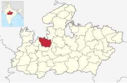
Rajgarh district is a district of Madhya Pradesh in central India. The city of Rajgarh is the administrative headquarters of the district. The old name of Rajgarh was Jhanjhanipur. Rajgarh in Madhya Pradesh is one of the aspirational districts selected by Government of India. The district has an area of 6,154km² and the population is 1,545,814 (2011 census).[1] The district lies on the northern edge of the Malwa plateau, and the Parbati River forms the eastern boundary of the district, while the Kali Sindh River forms the western boundary. The district has seven tehsils, Rajgarh, Khilchipur, Jirapur, Biaora, Narsinghgarh, Sarangpur and Pachore. The district is bounded by Rajasthan state to the north, and by the districts of Guna to the northeast, Bhopal to the east, Sehore to the southeast, and Shajapur to the south and west. It is part of Bhopal Division. There are 1728 villages in Rajgarh.
The district was created May 1948, and includes the territory of the former princely states of Rajgarh, Narsinghgarh, Khilchipur, and parts of the states of Dewas Junior and Senior (Sarangpur tehsil) and Indore (Jirapur tehsil, now part of Khilchipur tehsil).
The District lies on the northern edge of the Malwa plateau, and the Parvati River forms the eastern boundary of the district, while the Kalisindh River forms the western boundary. Black soil, light red and core sands are the main soil type available in the district.
Soil and cropping pattern:- The first and the most predominant black cotton soil known as kalmat (black soil) or chikat-kali (deep black) are highly fertile with great power of retaining moisture and bears excellent kharif and rabi crops with or without irrigation. Besides suitability, the black soil yields excellent wheat, gram, jowar and cotton crops high in quality and cotton crops high in quality and quantity.
Solar Power Plant
It is situated in Jaitpura and Ganeshpura villages. NTPC's 50MW Rajgarh solar power project in Madhya Pradesh is the biggest solar photovoltaic plant in the country using domestically manufactured modules. The 50 MW plant in Rajgarh, which was set up by Tata Power Solar.
History
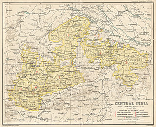
The district takes its name from the headquarters town Rajgarh. Rajgarh District was constituted after the formation of Madhya Bharat in May, 1948. Prior to this the area of the present District was parceled out among the States of Rajgarh, Narsinghgarh, Khilchipur, Dewas (Senior) Dewas (Junior) and Indore. Rajgarh was the headquarters of a mediatised State, ruled by the Umath Rajputs (a branch of the Paramaras), they enjoyed a Sanad Estate under the Sultans of Delhi and Mughal emperors in succession. The first capital was Duparia, now in Shajapur District. Later on it was shifted to Dungarpur (19km from Rajgarh) and then to Ratanpur (19km west of Narsinghgarh) and back. In order to avoid disturbance by the frequently passing Mughal armies, the Ruler of the Estate, Mohan Singh, acquired the present side, originally known as Jhanjhanipur from the Bhils in A.D. 1640. Finally he shifted the headquarters in the year 1645, giving the place its present name.
During the reign of Akbar (1556–1605) a Khilat and a Sanad were granted to Udaji of Tatanpur. At that time, Sarangpur was a Sarkar in the Subah of Malwa. Its jurisdiction extended from the western part of present Sehore District to the eastern part of Ujjain District. Among its twentyfour mahals many have retained their original names and are identified as Ashtah, Talain (Talen), Agra (Agar), Bajilpur (Bijilpur), Bhorsah, Khiljipur, Jirapur, Sarangpur, Sondarsi (Sundarsi), Sosner (Sunner) Sajapur, Kayath and Navgam (Tarana)1. In 1908, Rajgarh State was divided into seven Parganas, namely Newalganj, Biaora, Kalipith, Karanwas, Kotra, Seogarh and Talen. Narsinghgarh State was divided into four Parganas, namely Huzur (Narsinghgarh), Pachor, Khujner and Chhapera. The Parganas were placed in the charge of a Tahsildar each for revenue matters and magisterial work. 2 Khilchipur State was divided into three Paraganas. Sarangpur was as now, the tehsil headquarters of Dewas (Senior) and Dewas (Junior) States. Jarapur was a tehsil of Mahidpur District of former Indore State. It has now been abolished and merged in Khilchipur tahsil.
In 1645 with the permission of Rajmata, Deewan Ajab Singh defeated the Bhils in the hilly region of Rajgarh and he constructed a Palace in 1745 which was having five main gates namely, Itwaria, Bhudwaria, Surajpol, Panradia and Naya Darwaja. And it constitutes three very ancient temple namely Raj Rajeshwar Temple, Chatubhujnathji Temple and Narsingh Temple, and in which Rajmata and his 15-year-old son Rawat Mohan singh was living safely. In Jhanjherpur which was capital and it is having a palace due to which this place is known as Rajgarh and it had become famous.
Economy
In 2006 the Ministry of Panchayati Raj named Rajgarh one of the country's 250 most backward districts (out of a total of 640).[2] It is one of the 24 districts in Madhya Pradesh currently receiving funds from the Backward Regions Grant Fund Programme (BRGF).[2] Rajgarh is one of 84 district of NITI Ayog's Aspirational district Program.
According to the 2011 census Rajgarh District has a population of 1,545,814,[1] which is more than that of nations like Eswatini or Mauritius[4] This gives it a ranking of 322nd in India (out of a total of 640).[5] The district has a population density of 251 inhabitants per square kilometre (650/sqmi).[1] Its population growth rate over the decade 2001–2011 was 23.26%.[1] Rajgarh has a sex ratio of 956 females for every 1000 males and a literacy rate of 61.21%. Scheduled Castes and Scheduled Tribes make up 19.13% and 3.48% of the population respectively.[1]
ECGC, a premier Export Credit Agency (ECA) of Government of India (GOI) has earmarked Rs.2.50 crores during Financial Year 2018-19 for education projects including supporting secondary education of girls in Rajgarh, Madhya Pradesh.
Ajnar River
The Newaj is left bank tributary of the river Parwan which is a right bank principal tributary of the Kalisindh. The Newaj River rises at an elevation of 634 m in the Astha tehsil of the Sehore district in Madhya Pradesh and traverses a total length of 220km, out of which 205km is in Madhya Pradesh. The Mohanpura dam site is located in Mohanpura Village of Biaora tehsil of Rajgarh.
Climate
The district has dry climate except in the south-west monsoon season. The year may be divided into four seasons. The period from March to the second week of June is the summer season. The succeeding period up to the end of September is the south-west monsoon season. October and November constitute the postmonsoon or retreating monsoon season. The cold season is from December to February. The annual rainfall in the district is 813.6mm. About 93 percent of the annual rainfall in the district is received during the monsoon June to September. In Rajgarh and Khilchipur tahsils-bordering Rajasthan, the rainfall is generally below the district average.
Forest
The forests of the district belong to the dry deciduous mixed and scrub types. Mostly their timber value is small. The eastern forests are better than those in the western and central belts. The common species of the forests are dhow (Anogeissuslatifolia), khair (Accacia catechu), ber (ZizyphusJujuba), karondi (Carissa spinarum), kardhai (anogeissuspendula), babul (Acacia arabica), achar (Buchananilatifolia), chheola (Buteafrondosa), and tendu (Diospyrosmelanoxylon). In the village forests there was a good number of chandan (Satalum album) trees in Sarangpur tahsil. The common trees of the village areas araam (Mangiferaindica), babul (Accaciaarabica), ber (Zizyphusjujuba), gular (Ficusglomerata ), khakra or chheola (B. Frondosa), mahuta (Bassialatifolia), nim (Meliaindica) and papal (Ficusreligiosa), jamun (Eugenia jambolana) occurs along the nala banks as also the khajur (Phoenix dactylifera).
Rajgarh tourism
Shri tirupati balaji mandir zirapur
The glory of Tirupati Balajee is worldwide. Every year lakhs of people visit at Tirupati Dev, situated in south of India. One of the devotee from Zirapur, District Rajgarh of M.P. is Shri Om Prakash Mundra & his wife Shakuntala. When this couple reached to have darshan of Tirupati Balajee, a thought came in their mind, why not build the similar grand temple in Zirapur. It was a dream of Late Shri Kishanjee Mundra, resident of Baikunth and father of Shri O.P. Mundra to have such a grand temple at Zirapur also. Mundra couple then & their determined to construct the grand temple at Zirapur and returned to home town. Later they went with their other family members to Jhalariya Peeth situated at Didwana, (Rajasthan) and met Shree 1008 Shree Swami Shri Ghanshyamacharyajee Maharaj to detail about their dream. Swamijee immediately gave his consent for this great work. The starting was with the formation of Shree Shridhar Gyan Prasar Parmarthik Trust under the guidance of Swamijee Maharaj. Thereafter on 3 September 1998 at Zirapur, a town of Shri S.K. MLmdra with a small population of 25000 people, foundation of Balaji Temple was laid by Swami Shree Ghanshyamacharyajee Maharaj. The construction of temple took about 2 years. From 29 April to 4 May 2000 Pran Pratishtha Samaroh was conducted and Vyankatesh Lord Balajee temple was opened for public, and since then every day 2000–2500 devotees come here to have darshan and-get their wish fulfilled.[8]
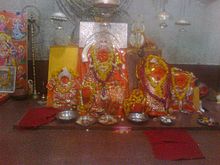
Jalpa Mata Temple
Jalpa Mata Temple
A famous temple of maa durga situated 6km from rajgarh city on the top of the hill. Raja Umath of Rajgarh had once worshiped the mother to protect people. due to which the mother herself appeared here. Here every year 1111 meters long Chunar is taken from rajmahal to the court of Mata Rani.[citation needed]
Sakha shyamji temple
The temple of Shyamji (lord Vishnu) was built in the memory of the king Sangram Singh (Shyam Singh) by his wife Bhagyawati near parvati river in a village Kotra. During the 16-17th century, the king died in an encounter with a mughal soldier of Haji Wali. Temple contain many wall arts. The temple is protected by the state govt.[9]
Kundaliya Dam
The major dam constructed in 2018 near Zirapur is called Kundaliya. The Dam is constructed with the purpose of supplying pressurized water for farmers of nearly 419 villages to facilitate micro irrigation in their fields in Rajgarh and Agar malwa districts. The dam also serves the purpose of drinking water in both the districts.
Mohanpura Dam
A dam has been built on the Newaj river, 8 kilometers away from Rajgarh. The catchment area of the dam is 3726 square km. Water will be provided in the dam for irrigation, domestic and industrial use. It is proposed to irrigate about 35500 hectares in Kharif and 62250 hectares in Rabi season from the dam.[10]
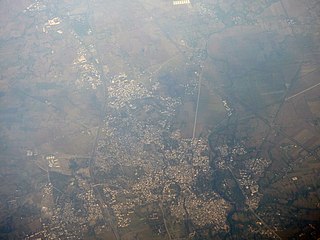
Rajgarh is a city and a municipality in the state of Madhya Pradesh in India. It is the administrative headquarters of Rajgarh District, and was a princely state under the British Raj, named Rajgarh State. The old city belongs to the Malwa region and is surrounded by a battlemented wall. Rajgarh is now known for NTPC solar power plant and dam projects running over here, as a result companies like Tata and Reliance power have shown interest.Rajgarh is also famous for Jalpama temple
Shajapur District is a district of Madhya Pradesh state of central India. The town of Shajapur is the district headquarters.
The Kali Sindh (Krashna Sindhu), is a river in Madhya Pradesh and Rajasthan in northern India. It is a tributary of the Chambal River in the Ganges Basin. The main tributaries of the Kali Sindh are the Parwan, Niwaj and Ahu rivers. The Kali Sindh River drains a major portion of the Malwa region, and is the biggest river flowing in the Malwa region of Madhya Pradesh.
Sehore is a city and a municipality in Sehore district in the Indian state of Madhya Pradesh. It is the district headquarters of Sehore District and is located on the Bhopal-Sehore-Indore highway, 38 km from Bhopal.
Dewas District is a district in the Indian state of Madhya Pradesh. The town of Dewas is the district headquarters.
The Bhopal Agency was a section of British India's colonial Central India Agency, a British political unit which managed the relations of the British with a number of autonomous princely states existing outside British India.
Bhopal District is a district of Madhya Pradesh state in central India. The city of Bhopal serves as its administrative headquarters. The district is part of Bhopal Division.
Sehore District is a district of Madhya Pradesh state in central India. The town of Sehore is the district headquarters. The district is part of Bhopal Division.
Biaora is a city and municipality in Rajgarh district in the state of Madhya Pradesh, India. biaora is one of the six tehsils of rajgarh district. The primary languages spoken in biaora are Malvi, English and Hindi. It is situated on National Highway NH-3 and Jaipur National Highway.
Jirapur is a town and a nagar panchayat in Rajgarh district in the Indian state of Madhya Pradesh. In 2022 Janpad Panchayat election held across Madhya Pradesh, Congress won the election and secure position as a Janpad Adhyaksh under the leadership of Khilchipur vidhayak Shri Priyavrat Singh Ji. He put all the efforts to win this election and doing great work for Khilchipur constituency. He won 2018 assembly election of Madhya Pradesh with huge margin of 30,000+ votes by defeating Kunwar Hajarilal Dangi of Bharatiya Janata Party (BJP) candidate.
Raghogarh-Ruthiyai or Raghogarh-Vijaypur is a town and municipality in Guna district in the Indian state of Madhya Pradesh.
Sarangpur is a city and tehsil in Rajgarh district in the Indian state of Madhya Pradesh. It is situated at the bank of the river Kali Sindh.
Satwas is a town and a Nagar Panchayat in Dewas district in the Indian state of Madhya Pradesh. Satwas is around 136.8 km (85.0 mi) from Dewas.
Narsinghgarh is a town and a municipality, near Rajgarh city in Rajgarh district in the Indian state of Madhya Pradesh.
Raghogarh Assembly constituency is one of the 230 Vidhan Sabha constituencies of Madhya Pradesh state in central India. This constituency came into existence in 1951, as one of the 79 Vidhan Sabha constituencies of the erstwhile Madhya Bharat state.
Chachoura Assembly constituency is one of the 230 Vidhan Sabha constituencies of Madhya Pradesh state in central India. This constituency came into existence in 1951, as one of the 79 Vidhan Sabha constituencies of the erstwhile Madhya Bharat state.
Rajgarh State was a princely state in India, named after its capital Rajgarh, Madhya Pradesh. It was part of the colonial Bhopal Agency of the Central India Agency during the British Raj. It lay in the region of Malwa known as Umatwara after the ruling Umat clan, a branch of the Parmar Rajputs. The neighbouring Narsinghgarh State was ruled by a cadet branch of this family, after being partitioned in 1681.
Harana is a village in Rajgarh district in the state of Madhya Pradesh in India. It belongs to Bhopal Division.
Gangahoni is a village in Biaora tehsil in Rajgarh district in the state of Madhya Pradesh, India.
Khilchipur Assembly constituency is one of the 230 Vidhan Sabha constituencies of Madhya Pradesh state in central India.
This page is based on this Wikipedia article Text is available under the CC BY-SA 4.0 license; additional terms may apply. Images, videos and audio are available under their respective licenses.