Narsinghgarh, Rajgarh

Last updated

Narsinghgarh
Nursinggurh
Narsinghgarh fort.jpeg
Narsinghgarh fort in Rajgarh District, Madhya Pradesh, India
Madhya Pradesh location map.svg
Red pog.svg
Narsinghgarh
India location map 3.png
Red pog.svg
Narsinghgarh
Coordinates: 23°42′N77°06′E / 23.7°N 77.1°E / 23.7; 77.1
Country Flag of India.svg  India
State Madhya Pradesh
Region Malwa
District Rajgarh
Government
  BodyNarsinghgarh Municipality
Area
  Total1,368 km2 (528 sq mi)
Elevation
483 m (1,585 ft)
Population
 (2011) [1]
32,329
Languages
  Official Hindi, Malvi
Time zone UTC+5:30 (IST)
PIN
465669
Telephone code07375
Vehicle registration MP-39
Website narsinghgarh.com

Narsinghgarh is a town and a municipality, near Rajgarh city in Rajgarh district in the Indian state of Madhya Pradesh.

Contents

History

The town is over 300 years old having been founded in 1681 by Dewan Parasram. After partition Rawat Paras Ramji named his state after Bhagwan Shri Narsingh (incarnation of God Vishnu), who was his deity and aradhya Dev. Thereafter, he founded the town of Narsinghgarh and transferred his capital there and constructed the temple of his aradhya Dev Shri Narsingh Bhagwan. He built a tank known as Paras Ram Sagar The town's lake still bears the name of the founder. The Royal family was well connected directly and indirectly in relationship with all the important Rajput Royal families of India. The State of Narsinghgarh was carved out of the State of Rajgarh by Paras Ramji, the younger brother of the then Ruler of Rajgarh, Rawat Mohan Singhji in 1681 A.D

Fort

Narsinghgarh Fort Narsinghgarh fort.jpeg
Narsinghgarh Fort

The fort and palace at Narsinghgarh was the official residence of the rulers of Narsinghgarh State till Maharaja Bhanu Prakash Singhji shifted to the Bhanu Niwas Palace in the town in 1962. In Madhya Pradesh and Rajasthan the rulers of Narsinghgarh were the only rulers who lived in the fort. The fort was built nearly 300 years ago in the Rajpur, Mughal and Malwa style. The entire complex covers an area of 45.323 acres and a built in area of more than 177000 sq. feet. It has 304 rooms, 4 halls, 12 chowks and 64 varandas. It is situated nearly 350 feet above the town on the hood of a snake-like hill and the approach to the Fort by vehicles is through its tail. This fort is the third biggest in the former State of Madhya Bharat, now part of Madhya Pradesh State, after the Forts of Mandu & Gwalior. The fort's pool was made in 19th century.

Geography

Narsinghgarh is located on Malwa Plateau at 23°42′N77°06′E / 23.7°N 77.1°E / 23.7; 77.1 . [2] It has an average elevation of 483  metres (1584  feet). The town is 72 km from the Raja Bhoj Airport and is reached by a good road. Town is surrounded by Vindhyanchal Mountain Range and has three lakes. It is situated between Kota & Bhopal on the Jaipur-Jabalpur National Highway No.12 and is 82 km. from Bhopal, 265 Kilometers from Kota and 200 Kilometers from Indore. The main railway stations are Bhopal Junction on the main Delhi-Chennai line and Biaora nearly 33 km on the Maksi-Gwalior branch line. The town of Vidisha is 84 km. east of Narsinghgarh. The town of Sundersi is 81 kilometers south west of Narsinghgarh. There is a new railway line proposed from Bhopal to Kota via Bairagarh, Shyampur, Narsinghgarh, Biaora, Rajgarh, Khilchipur, Jhalawar, Ramganj Mandi etc. Close to Narsinghgarh is a state wildlife sanctuary with a big lake and a good rest house. Area of Narsinghgarh - 1368 km2 >and total 306 villages. [3]


Demographics

Narsinghgarh state emblem Narsinghgarh state emblem.jpg
Narsinghgarh state emblem

As of 2001 India census, [4] Narsinghgarh had a population of 27,657. Males constitute 52% of the population and females 48%. Narsinghgarh has an average literacy rate of 66%, higher than the national average of 59.5%: male literacy is 73%, and female literacy is 57%. In Narsinghgarh, 15% of the population is under 6 years of age.

Art and music

The Rulers of Narsinghgarh were patrons of arts and music. The Malwa School of Arts as known today had its origin in the Narsinghgarh School of Arts in 18th and 19th Century. One of its artists was Madhav Das, whose collections of paintings were known as "Rag Ragini". The temples of Kunwarani ji and Chapawatji built by the Ranis of Narsinghgarh on the banks of Paras Ram Sagar depicted the paintings of Krishna Leela. From Narsinghgarh it was carried to Mandu and thus later on called the Malwa School of Arts.

The college of Narsinghgarh is affiliated with Khairagarh University.

Tourist attractions

Narsinghgarh's main tourist attractions are Bada Mahadev Mandir, Chota Mahadev Mandir, Gupteshwar Mahadev Mandir, Nadiya Pani, Kodu Pani, raghunathji mandir, Narsinghgarh Fort, Badi Hanuman Gadi, shri jagannath mandir, Choti Hanuman Gadi, Jamaat Mandir and the jal Mandir.There is also Swarn Jain temple, dedicated to Mallinath Swamy along with Jain Dadawadi, it is made up of marble with detailed mirror and gold work, a visual treat for the visitors. There is also one wildlife sanctuary near Narsinghgarh, which is called "Paradise of Peacock"(chiddi kho). Also within short distance there is Shyam Ji shakha mandir, famous for its history and beauty. [5] Narsinghgarh mahotsav is celebrated in winter every year. Nearby Narsinghgarh is Kotra village having wonderful Shamji temple along with Karotia - A narrow cave like structure on the Satpura ranges.

Related Research Articles

<span class="mw-page-title-main">Central India Agency</span> Agency of princely states in India

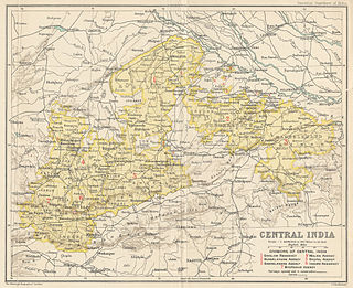
The Central India Agency was created in 1854, by amalgamating the Western Malwa Agency with other smaller political offices which formerly reported to the Governor-General of India. The agency was overseen by a political agent who maintained relations of the Government of India with the princely states and influence over them on behalf of the Governor-General. The headquarters of the agent were at Indore.

<span class="mw-page-title-main">Rajgarh, Madhya Pradesh</span> City in Madhya Pradesh, India

Rajgarh is a city and a municipality in the state of Madhya Pradesh in India. It is the administrative headquarters of Rajgarh District, and was a princely state under the British Raj, named Rajgarh State. The old city belongs to the Malwa region and is surrounded by a battlemented wall. Rajgarh is now known for NTPC solar power plant and dam projects running over here, as a result companies like Tata and Reliance power have shown interest.Rajgarh is also famous for Jalpama temple

<span class="mw-page-title-main">Maheshwar</span> Town in Madhya Pradesh, India

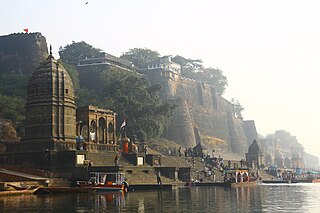
Maheshwar is a town, near Khargone city in Khargone district of Madhya Pradesh state, in central India. It is located on State Highway-38 ,13.5 km east of National Highway 3 and 91 km from Indore, the commercial capital of the state. The Town lies on the north bank of the Narmada River. It was the kingdom of Chaktavartin Samrat Sahastraarjun, Kartavirya Arjuna a Heheya king. Lately, after many years, it was the capital of the Malwa during the Maratha Holkar reign till 6 January 1818, when the capital was shifted to Indore by Malhar Rao Holkar III.

<span class="mw-page-title-main">Jaora</span> City in Madhya Pradesh, India

Jaora is a city and a municipality in Ratlam district in the Indian state of Madhya Pradesh. Jaora is located in the Malwa region, between Ratlam and Mandsaur. It was the capital of the Jaora princely state of Jaora before Independence. During the Mourning of Muharram, thousands of people from all over the world visit the shrine of Hussain Tekri. Jains visit Jaora as a place that the Jain ascetic Rajendrasuri practiced tapasya.

<span class="mw-page-title-main">Hadoti</span> Region of Rajasthan, India

Hadoti is a region of Rajasthan state in western India, which was once called the Bundi Kingdom. The biggest cities are Jhalawar and Kota. It includes the districts of Bundi, Baran, Jhalawar and Kota and is bounded on the west by the Mewar, on the northwest by Ajmer regions of Rajasthan, and on the south by the Malwa, on the east by the Gird regions of Madhya Pradesh state.

Kanad is a town and a nagar parishad in Agar Malwa district in the Indian state of Madhya Pradesh. It comes under Kanad Parishad. It belongs to Ujjain Division. It is situated along the Agar–Sarangpur SH-41 highway. It is located 18 km (11 mi) towards east from the district headquarters of Agar Malwa, 83 km (52 mi) from Ujjain, 186 km (116 mi) from the state capital of Bhopal.

<span class="mw-page-title-main">Guna district</span> District in Madhya Pradesh, India

Guna district is one of the 52 districts of Madhya Pradesh in central India. Its administrative headquarters is Guna. The district has a population of 1,241,519. It has an area of 6390 km², and is bounded on the northeast by Shivpuri District, on the east by Ashoknagar District, on the southeast by Vidisha District, on the southwest by Rajgarh District, on the west and northwest by Jhalawar and Baran districts of Rajasthan state. The Sindh River flows northward along the eastern edge of the district, forming part of the boundary with Ashoknagar District, and the Parvati River flows northwestward through the southern portion of the district, forming part of the boundary with Baran District before flowing into Rajasthan.

<span class="mw-page-title-main">Bhopal Agency</span>

The Bhopal Agency was a section of British India's colonial Central India Agency, a British political unit which managed the relations of the British with a number of autonomous princely states existing outside British India.

<span class="mw-page-title-main">Rajgarh district</span> District of Madhya Pradesh in India

Rajgarh district is a district of Madhya Pradesh in central India. The city of Rajgarh is the administrative headquarters of the district. The old name of Rajgarh was Jhanjhanipur. Rajgarh in Madhya Pradesh is one of the aspirational districts selected by Government of India. The district has an area of 6,154 km² and the population is 1,545,814. The district lies on the northern edge of the Malwa plateau, and the Parbati River forms the eastern boundary of the district, while the Kali Sindh River forms the western boundary. The district has seven tehsils, Rajgarh, Khilchipur, Jirapur, Biaora, Narsinghgarh, Sarangpur and Pachore. The district is bounded by Rajasthan state to the north, and by the districts of Guna to the northeast, Bhopal to the east, Sehore to the southeast, and Shajapur to the south and west. It is part of Bhopal Division. There are 1728 villages in Rajgarh.

Aklera is a town and an Indian municipality in Jhalawar district in the state of Rajasthan. It is in the south-eastern region of Rajasthan at the edge of the Malwa plateau and has a rocky, scrub-covered terrain.

Badnawar (or Badnavar) is a Town, former pargana and a Nagar Parishad of the Dhar district in the state of Madhya Pradesh, India. This is a tehsil place having 170 villages. Badnawar is around 95 km from Indore - the business capital of Madhya Pradesh.

Raghogarh-Ruthiyai or Raghogarh-Vijaypur is a town and municipality in Guna district in the Indian state of Madhya Pradesh.

Sarangpur is a city and tehsil in Rajgarh district in the Indian state of Madhya Pradesh. It is situated at the bank of the river Kali Sindh.

Soyat Kalan or Soyat is a town and a Nagar Parishad in Agar Malwa district in the Indian state of Madhya Pradesh.

<span class="mw-page-title-main">Tourism in Madhya Pradesh</span>

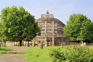
Tourism in Madhya Pradesh has been an attraction of India because of its location in the centre of the country. Madhya Pradesh has won Best Tourism State National award for 3 consecutive years i.e. 2017, 2016 and 2015.

<span class="mw-page-title-main">Bhim Singh II</span> Last ruling Maharaja of Kotah from 1940–1947

HH Maharajadhiraj Maharaja Mahim Mahendra Maharao Raja Shri Sir Bhim Singhji II Bahadur, KCSI was the last ruling Maharaja of the princely state of Kotah from 1940 to 1947.

<span class="mw-page-title-main">Narsinghgarh State</span> Princely state of India

Narsinghgarh State is a former princely state of the British Raj in India. It formed an enclave within Rajgarh State and was placed administratively under the Bhopal Agency subdivision of the Central India Agency. The state covered an area of 1,920 square kilometres (740 sq mi) and had a population of 92,093 and an average revenue of Rs.5,00,000 in 1901.

<span class="mw-page-title-main">Rajgarh State</span> Princely state of India

Rajgarh State was a princely state in India, named after its capital Rajgarh, Madhya Pradesh. It was part of the colonial Bhopal Agency of the Central India Agency during the British Raj. It lay in the region of Malwa known as Umatwara after the ruling Umat clan, a branch of the Parmar Rajputs. The neighbouring Narsinghgarh State was ruled by a cadet branch of this family, after being partitioned in 1681.

<span class="mw-page-title-main">Raghogarh State</span>

Raghogarh State, also known as Raghugarh and as Khichiwara, was a princely state of the Gwalior Residency, under the Central India Agency of the British Raj. It was a Thikana state of about 109 km2 with a population of 19,446 inhabitants in 1901. The Parbati River marked the western border of the state. The capital was at Raghogarh in present-day Guna district of Madhya Pradesh.

Harana is a village in Rajgarh district in the state of Madhya Pradesh in India. It belongs to Bhopal Division.

References

  1. "population". Provisional Population Totals, Census of India 2011.
  2. "Maps, Weather, and Airports for Narsinghgarh, India". www.fallingrain.com. Retrieved 15 April 2023.
  3. District profile. Rajgarh cgwb.gov.in
  4. "Census of India 2001: Data from the 2001 Census, including cities, villages and towns (Provisional)". Census Commission of India. Archived from the original on 16 June 2004. Retrieved 1 November 2008.
  5. "श्यामजी साँका मंदिर, नरसिंहगढ़ NARSINGHGARH". Kalpanaye. 6 October 2021. Retrieved 9 November 2021.