Indore district

Last updated

Indore district
Krishnapura Chhatri.jpg
Bhim Janmabhoomi Memorial in Dr. Ambedkar Nagar (Mhow).jpg
Busy Indore night traffic (5104223286).jpg
Rajwada Palace, Indore.jpg
Patalpani Waterfall.jpg
Clockwise from top-left: Krishnapura Chhatri, Bhim Janmabhoomi in Mhow, Rajwada Palace, Patalpani waterfall, street in Indore
MP Indore district map.svg
Location of Indore district in Madhya Pradesh
CountryFlag of India.svg  India
State Madhya Pradesh
Division Indore
Headquarters Indore
Government
   Lok Sabha constituencies Indore, Dhar
   Vidhan Sabha constituencies 9
Area
  Total3,898 km2 (1,505 sq mi)
Population
 (2011)
  Total3,276,697 (provisional) [1]
Demographics
   Literacy 82.3% [2]
  Sex ratio924 [1]
Time zone UTC+05:30 (IST)
Average annual precipitation1062 mm
Website imcindore.mp.gov.in , indore.nic.in

The Indore District is a district of Madhya Pradesh state in central India. It is believed that the city is named after its Indreshwar Mahadev Temple, Where Indra is the presiding deity. The Gupta inscriptions name Indore as "Indrapura". It is also called the administrative capital. This district forms part of the Indore Division.

Contents

As of 2011, it was the most populous of the 50 districts in Madhya Pradesh. [3]

Location

The Indore District has an area of 3,898 km² [4] and borders the districts of Ujjain to the north, Dewas to the east, Khargone (West Nimar) to the south, and Dhar to the west.

Rivers

The two main rivers of the Indore district are the Chambal, in the west, (originating in the Vindhya range south of Mhow) and the Kshipra, a tributary of the Chambal river, in the east. Other small rivers include the Gambhir and the Kanh, both tributaries of the Kshipra river.

Cities and towns

Indore is the administrative centre and main city in the district. Dr. Ambedkar Nagar (Mhow) is an important cantonment town in the Indore District that contains three of the Indian Army's premier training institutes, as well as the Border Security Force's Central School of Weapons and Tactics (CSWT). Other towns in Indore include Depalpur, Sanwer and Hatod.

The municipalities of Indore district are listed as follows:

Villages

Divisions

Tehsils

The Indore district has 10 administrative divisions [5] (tehsils) :

Blocks

There are also four blocks [6] in the district, with 51 police stations. [7]

There are a total of 335 Panchayats and 649 villages in the four blocks.

Politics

In May 2019, Shankar Lalwani of Bharatiya Janata Party had been elected as the Member of Parliament from Indore constituency. [8]

The previous member of the Lok Sabha from the Indore constituency was Sumitra Mahajan of the Bharatiya Janata Party (BJP). She was a Member of Parliament from 1989 to May 2019.

Since parliamentary and legislative assembly constituency boundaries were redrawn in 2008, there have been nine Vidhan Sabha constituencies in this district: Depalpur, Indore-1, Indore-2, Indore-3, Indore-4, Indore-5, Dr. Ambedkar Nagar-Mhow, Rau and Sanwer. [9] Dr. Ambedkar Nagar-Mhow is part of the Dhar Lok Sabha constituency and the others are part of the Indore Lok Sabha constituency.

Electricity

The electricity in Indore district is distributed by Madhya Pradesh Paschim Kshetra Vidyut Vitaran Company Limited. [10]

Demographics

Historical population
YearPop.±% p.a.
1901302,057    
1911272,396−1.03%
1921338,992+2.21%
1931380,889+1.17%
1941454,541+1.78%
1951601,035+2.83%
1961753,594+2.29%
19711,025,150+3.13%
19811,409,473+3.23%
19911,835,915+2.68%
20012,465,827+2.99%
20113,276,697+2.88%
source: [11]
Religions in Indore district (2011) [12]
ReligionPercent
Hinduism
83.26%
Islam
12.67%
Jainism
2.19%
Sikhism
0.78%
Christianity
0.56%
Other or not stated
0.54%

According to the 2011 census, the Indore District has a population of 3,276,697, [3] which roughly equals the nation of Mauritania [13] or the US state of Iowa. [14] This makes it the 105th most populous in India (out of a total of 640) districts. [3] The district has a population density of 841 inhabitants per square kilometre (2,180/sq mi). [3] Its population growth rate over the decade 2001-2011 was 32.88%. [3] Indore has a sex ratio of 928 females for every 1,000 males, [3] and a literacy rate of 80.87% (male 87.25% and female 74.02%). 74.09% of the population lives in urban areas. Scheduled Castes and Scheduled Tribes make up 16.64% and 6.64% of the population respectively. [3]

Languages of Indore district (2011) [15]

   Hindi (71.39%)
   Malvi (15.05%)
   Marathi (3.54%)
   Urdu (2.81%)
   Sindhi (1.74%)
   Nimadi (1.39%)
   Gujarati (0.98%)
  Others (3.10%)

At the time of the 2011 Census of India, 71.39% of the population in the district spoke Hindi, 15.05% Malvi, 3.54% Marathi, 2.81% Urdu, 1.74% Sindhi, 1.39% Nimadi, 0.98% Gujarati, 0.81% Punjabi and 0.49% Bhili as their first language. [15]

Climate

Climate data for Indore district
MonthJanFebMarAprMayJunJulAugSepOctNovDecYear
Mean daily maximum °C (°F)27.5
(81.5)
28.8
(83.8)
38.3
(100.9)
42.7
(108.9)
46.4
(115.5)
36.2
(97.2)
30.3
(86.5)
28.2
(82.8)
30.9
(87.6)
32.4
(90.3)
22.7
(72.9)
16.9
(62.4)
31.8
(89.2)
Mean daily minimum °C (°F)5.8
(42.4)
9.4
(48.9)
16.2
(61.2)
21.2
(70.2)
24.4
(75.9)
24.1
(75.4)
22.6
(72.7)
21.9
(71.4)
21.1
(70.0)
18.1
(64.6)
11.9
(53.4)
6.6
(43.9)
16.9
(62.5)
Average precipitation mm (inches)4
(0.2)
3
(0.1)
1
(0.0)
3
(0.1)
11
(0.4)
136
(5.4)
279
(11.0)
360
(14.2)
185
(7.3)
52
(2.0)
21
(0.8)
7
(0.3)
1,062
(41.8)
Average precipitation days0.80.80.30.31.88.615.918.38.63.11.40.660.5
Mean monthly sunshine hours 288.3274.4288.3306.0325.5210.0105.480.6180.0269.7273.0282.12,883.3
Source: HKO

Tourism

Indore district has the variety of tourist spots, historical spots and natural spots for the purpose of tourism. Indore city has palaces of the erstwhile Holkar rulers.

Tourist places

Historical places

Natural wonders

Related Research Articles

<span class="mw-page-title-main">Indore</span> Metropolitan city in Madhya Pradesh, India

Indore is the largest and most populous city in the Indian state of Madhya Pradesh. It is consistently ranked as the cleanest city in India. It serves as the headquarters of both the Indore District and the Indore Division. It is also considered as the state education hub and houses campuses of both the Indian Institute of Technology and the Indian Institute of Management. Located on the southern edge of Malwa Plateau, at an average altitude of 553 meters (1,814 ft) above sea level, it has the highest elevation among major cities of Central India. The city is 190 km (120 mi) west of the state capital of Bhopal. It is 57 km (35 mi) from Ujjain and 35 km (20 mi) from Dewas. Indore had a census-estimated 2011 population of 1,994,397 and 3,570,295. The city is distributed over a land area of just 530 square kilometres (200 sq mi), making Indore the most densely populated major city in the central province.

<span class="mw-page-title-main">Mhow</span> Cantonment Town in Madhya Pradesh, India

Mhow, officially Dr. Ambedkar Nagar, is a town in the Indore district in Madhya Pradesh state of India. It is located 23 kilometres (14 mi) south-west of Indore city, towards Mumbai on the old Mumbai-Agra Road. In 2003, the Government of Madhya Pradesh renamed the town Dr. Ambedkar Nagar, after political reformer and town native B. R. Ambedkar.

<span class="mw-page-title-main">Ujjain</span> City in Madhya Pradesh, India

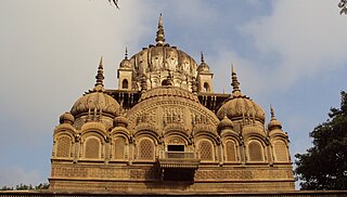
Ujjain or Ujjayinī is a city in Ujjain district of the Indian state of Madhya Pradesh. It is the fifth-largest city in Madhya Pradesh by population and is the administrative centre of Ujjain district and Ujjain division. It is one of the Hindu pilgrimage centres of Sapta Puri famous for the Kumbh Mela held there every 12 years. The famous temple of Mahakaleshwar Jyotirlinga is located in the center of the city. The city has been one of the most prominent trade and political centres of the Indian Subcontinent from the time of the ancient Mahājanapadas until the British colonisation of India.

<span class="mw-page-title-main">Bhind district</span> District of Madhya Pradesh in India

Bhind district is a district in the Chambal division of the Indian state of Madhya Pradesh. The town of Bhind is the district headquarters. Bhind District is situated in Chambal region in the northwest of the state. It is bounded by Agra, Etawah, Jalaun and Jhansi districts of Uttar Pradesh state to the north and the east, and the Madhya Pradesh districts of Datia to the south, Gwalior to the southwest, and Morena to the west. The geography of the district is characterised by uneven ravines, plain fertile fields and scanty forests. The total area of the district is 4,459 km2 (1,722 sq mi).

<span class="mw-page-title-main">Dewas district</span> District of Madhya Pradesh in India

Dewas District is a district in the Indian state of Madhya Pradesh. The town of Dewas is the district headquarters.

<span class="mw-page-title-main">Khargone district</span> District of Madhya Pradesh in India

Khargone district, formerly known as West Nimar district, is a district of Madhya Pradesh state in central India. The district lies in the Nimar region and is part of the Indore Division. The district headquarters is the city of Khargone, which lies south of the Indore metropolis, the headquarters of Indore district.

<span class="mw-page-title-main">Dhar district, India</span> District of Madhya Pradesh in India

Dhar district is a district of Madhya Pradesh state in central India. The historic town of Dhar is administrative headquarters of the district.

<span class="mw-page-title-main">Ujjain district</span> District of Madhya Pradesh in India

Ujjain district is a district of Madhya Pradesh state in central India. The historic city of Ujjain is the district headquarters. The district has an area of 6,091 km², and a population of 19,86,864, a 16.12% increase from its 2001 population of 17,10,982.

Barwaha is a municipality and sub district in Khargone district in the state of Madhya Pradesh, India situated on the banks of Narmada river. Barwaha is second biggest city of District after Khargone city. The Barwaha city is divided into 28 wards for which elections are held every 5 years. The Barwaha Municipality has population of 61,973 of which 32,940 are males while 29,033 are females as per report released by Census India 2011. Literacy rate of Barwaha is 87.27% higher than state average of 69.32%. In Barwaha, Male literacy is around 92.73% while female literacy rate is 81.23%.

<span class="mw-page-title-main">Dongargaon, Indore</span> Village in Madhyapradesh, India

Dongargaon is a village located in Indore District, Madhya Pradesh, India.

Mhowgaon is a Nagar Panchayat under Sub Division Dr. Ambedkar Nagar (Mhow) in Indore district in the Indian state of Madhya Pradesh. The total geographical area of Mhowgaon nagar panchayat is 13.5 km2 and it is the smallest city by area in the sub district. The population density of the city is 2309 persons per km2. Mhowgaon is divided into 15 wards for which elections are held every 5 years. Among them, Mhowgaon Ward No. 2 is the most populous ward with a population of 3440 and Mhowgaon Ward No. 15 is the least populous ward with a population of 957. Mhowgaon Nagar Panchayat has total administration over 6,373 houses to which it supplies basic amenities like water and sewerage. It is also authorized to build roads within Nagar Panchayat limits and impose taxes on properties coming under its jurisdiction.

Rau is a suburb of Indore city and a nagar panchayat in Indore district in the Indian state of Madhya Pradesh. It is a part of the Indore Metropolitan Region.

<span class="mw-page-title-main">Alirajpur district</span> District of Madhya Pradesh in India

Alirajpur is one of the 52 districts of Madhya Pradesh state in India. It was created from Alirajpur, Jobat and Bhabra tehsils of the former Jhabua district on 17 May 2008. It is the least literate district in India as per Census 2011. Alirajpur is the administrative headquarters of the district. The district occupies an area of 2,165.24 square kilometres (836.00 sq mi), and at the 2011 census had a population of 728,999. It includes the city of Alirajpur.

The Patalpani railway station is one of the local railway stations of Indore district near Dr. Ambedkar Nagar (Mhow) town in the state of Madhya Pradesh. The station consists of two platforms. The platforms are not well sheltered.

<span class="mw-page-title-main">Kukshi Assembly constituency</span> Constituency of the Madhya Pradesh legislative assembly in India

Kukshi is one of the 230 Vidhan Sabha constituencies of Madhya Pradesh state in central India. It was founded in 1951 as one of the 79 Vidhan Sabha constituencies of the erstwhile Madhya Bharat state. It is reserved for candidates of the Scheduled tribes.

Mothala is a village in western Madhya Pradesh, India. Administratively it is under Jhalariya Gram Panchayat, Depalpur, Indore District, Madhya Pradesh. Mothala is 1.5 km by road west of the town of Betma, and 23 km by road south of the town of Depalpur.

<span class="mw-page-title-main">Patalpani waterfall</span> Waterfall in India

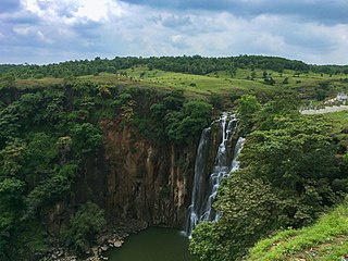
The Patalpani Waterfall is a waterfall on the Choral River, a tributary of the Narmada, located in the Mhow Tehsil of Indore district in the state of Madhya Pradesh, India.

<span class="mw-page-title-main">Dr. Ambedkar Nagar-Mhow Assembly constituency</span> Constituency of the Madhya Pradesh legislative assembly in India

Dr. Ambedkar Nagar-Mhow Assembly constituency is one of the 230 Vidhan Sabha constituencies of Madhya Pradesh state in central India.

<span class="mw-page-title-main">Ratlam railway division</span> Railway division of India

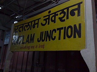
Ratlam railway division is one of the six railway divisions under Western Railway zone of Indian Railways. This railway division was formed on 1 April 1952 and its headquarter is located at Ratlam in the state of Madhya Pradesh of India.

References

  1. 1 2 "Distribution of population, sex ratio, density and decadal growth rate of population - State and District : 2011". Office of The Registrar General & Census Commissioner, India. Retrieved 18 July 2011.
  2. "Total Population, child population in the age group 0-6,literates and literacy rates by sex: 2011". Office of The Registrar General & Census Commissioner, Government of India. Retrieved 18 July 2011.
  3. 1 2 3 4 5 6 7 "District Census Handbook: Indore" (PDF). Census of India . Registrar General and Census Commissioner of India. 2011.
  4. "Indore District - Statistics". Collectorate, Indore, Madhya Pradesh. Archived from the original on 21 July 2011. Retrieved 20 July 2011.
  5. "Tehsil". indore.nic.in. Retrieved 21 January 2022.
  6. "Subdivision & Blocks". indore.nic.in. Retrieved 21 January 2022.
  7. "Police". indore.nic.in. Retrieved 21 January 2022.
  8. "Indore Election Results 2019 Live Updates: Shankar Lalvani of BJP wins". News18. 23 May 2019. Retrieved 24 May 2019.
  9. "District Assembly list". Chief Electoral Officer, Madhya Pradesh website. Archived from the original on 1 December 2015. Retrieved 18 April 2010.
  10. "Electricity". indore.nic.in. Retrieved 21 January 2022.
  11. "Table A-02 Decadal Variation in Population Since 1901: Madhya Pradesh" (PDF). census.gov.in. Registrar General and Census Commissioner of India.
  12. "Table C-01 Population By Religion: Madhya Pradesh". census.gov.in. Registrar General and Census Commissioner of India.
  13. US Directorate of Intelligence. "Country Comparison:Population". Archived from the original on 13 June 2007. Retrieved 1 October 2011. Mauritania 3,281,634 July 2011 est.
  14. "2010 Resident Population Data". U. S. Census Bureau. Archived from the original on 19 October 2013. Retrieved 30 September 2011. Iowa 3,046,355
  15. 1 2 "Table C-16 Population by Mother Tongue: Madhya Pradesh". censusindia.gov.in. Registrar General and Census Commissioner of India.
  16. "Annapurna Temple | District Indore,Government Of Madhya Pradesh | India" . Retrieved 7 March 2023.
  17. "Tourist Places | District Indore,Government Of Madhya Pradesh | India" . Retrieved 7 March 2023.

22°40′N75°45′E / 22.667°N 75.750°E / 22.667; 75.750