Bhopal is the capital city of the Indian state of Madhya Pradesh and the administrative headquarters of both Bhopal district and Bhopal division. It is known as the City of Lakes, due to presence of various natural and artificial lakes near the city boundary. It is also one of the greenest cities in India. It is the 16th largest city in India and 131st in the world. After the formation of Madhya Pradesh, Bhopal was part of the Sehore district. It was bifurcated in 1972 and a new district, Bhopal, was formed. Flourishing around 1707, the city was the capital of the former Bhopal State, a princely state of the British ruled by the Nawabs of Bhopal until India's independence in 1947. India achieved independence on 15 August 1947. Bhopal was one of the last states to sign the ‘Instrument of Accession’. The ruler of Bhopal acceded to the Indian government, and Bhopal became an Indian state on 1 May 1949. Sindhi refugees from Pakistan were accommodated in Bairagarh, a western suburb of Bhopal.

Ahmednagar is a city in, and the headquarters of, the Ahmednagar district, Maharashtra, India. Ahmednagar has several dozen buildings and sites from the Nizam Shahi period. Ahmednagar Fort, once considered almost impregnable, was used by the British to house Jawaharlal Nehru and other Indian Nationalists before Indian independence. A few rooms there have been converted to a museum. During his confinement by the British at Ahmednagar Fort in 1944, Nehru wrote the book The Discovery of India. Ahmednagar is home to the Indian Armoured Corps Centre & School (ACC&S), the Mechanised Infantry Regimental Centre (MIRC), the Vehicle Research and Development Establishment (VRDE) and the Controllerate of Quality Assurance Vehicles (CQAV). Training and recruitment for the Indian Army Armoured Corps takes place at the ACC&S.

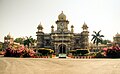
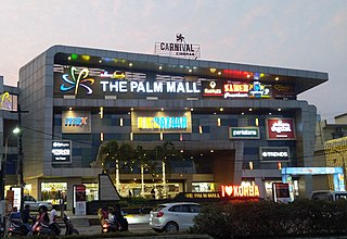
Indore is the largest and most populous city in the Indian state of Madhya Pradesh. It is the commercial hub of Madhya Pradesh. It is consistently ranked as the cleanest city in India. It serves as the headquarters of both the Indore District and the Indore Division. It is also considered the state education hub and houses campuses of both the Indian Institute of Technology and the Indian Institute of Management. Located on the southern edge of Malwa Plateau, at an average altitude of 553 metres (1,814 ft) above sea level, it has the highest elevation among major cities of Central India. The city is 190 km (120 mi) west of the state capital of Bhopal. It is 57 km (35 mi) from Ujjain and 35 km (20 mi) from Dewas. Indore had a census-estimated 2011 population of 1,994,397 and 3,570,295. The city is distributed over a land area of just 530 square kilometres (200 sq mi), making Indore the most densely populated major city in the central province.

Aurangabad, officially known as Chhatrapati Sambhajinagar, is a city in the Indian state of Maharashtra. It is the administrative headquarters of Aurangabad district, Maharashtra and is the largest city in the Marathwada region. Located on a hilly upland terrain in the Deccan Traps, Aurangabad is the fifth-most populous urban area in Maharashtra after Mumbai, Pune, Nagpur and Nashik with a population of 1,175,116. The city is known as a major production center of cotton textile and artistic silk fabrics. Several prominent educational institutions, including Dr. Babasaheb Ambedkar Marathwada University, are located in the city. The city is also a popular tourism hub, with tourist destinations like the Ajanta and Ellora caves lying on its outskirts, both of which have been designated as UNESCO World Heritage Sites since 1983. Other tourist attractions include the Aurangabad Caves, Devagiri Fort, Grishneshwar Temple, Jama Mosque, Bibi Ka Maqbara, Himayat Bagh, Panchakki and Salim Ali Lake. Historically, there were 52 Gates in Aurangabad, some of them extant, because of which Aurangabad is nicknamed as the "City of Gates". In 2019, the Aurangabad Industrial City (AURIC) became the first greenfield industrial smart city of India under the country's flagship Smart Cities Mission.

Kamala Nehru was an Indian independence activist and the wife of Jawaharlal Nehru, the first prime minister of India. Their daughter Indira Gandhi would go on to become the first and to date, the only female Prime Minister of India.
Korba is a city and an industrial area in Korba District in the Indian state of Chhattisgarh. Korba was part of Bilaspur District before 25 May 1998. It was later designated as a separate district for ease of administration, but is still under Bilaspur Division.

Kamla Nagar is a residential and commercial neighbourhood in North Delhi, India. It is one of Delhi's major shopping centres.
Faizpur is a town in Tahasil of Yawal in Jalgaon district of Maharashtra, India.
Maudaha is a city and a Municipal Board in Hamirpur district, Uttar Pradesh, India.
Rau is a suburb of Indore city and a nagar panchayat in Indore district in the Indian state of Madhya Pradesh. It is a part of the Indore Metropolitan Region.
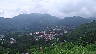
Sundar Nagar is a town and a municipal council in Mandi district in the Indian state of Himachal Pradesh. It was formerly a princely state, known as Suket.

Nava Raipur, officially known as Atal Nagar-Nava Raipur, is a planned city and fully Greenfield city in Indian state of Chhattisgarh. It is planned to replace Raipur as the capital city of Chhattisgarh. The Government of Chhattisgarh, the state's administrative body is situated here. The city is located between National Highway 53 and National Highway 30, about 17 km south-east of the capital city Raipur. Swami Vivekananda Airport separates Raipur and Nava Raipur.
Neredmet, formally known as Neredu Mettu, is a residential neighbourhood in Hyderabad, Telangana, India. It falls under Malkajgiri mandal & Circle in Medchal-Malkajgiri district. Neredmet currently serves as the headquarters of Rachakonda Police commissionerate, one of the three police commissionerates of Hyderabad City. It was earlier a part of Malkajgiri Municipality, but now it is administered under Malkajgiri Circle of GHMC-Secunderabad Zone. It forms Ward No. 136- Neredmet (Fully), Ward No. 137- Vinayak Nagar(Fully), Ward No. 138- Moula-Ali(Half), Ward No. 139- East Anandbagh(Partially), Ward No. 140- Malkajgiri (Half), of Greater Hyderabad Municipal Corporation.
Bijalpur is in the south-west region of Indore city in India. It has population of 40,000.
Bhanwarkuan is a sub-urban locality of Indore, India.
Chandan Nagar is a sub-urban locality of Indore in the state of Madhya Pradesh, India.

Dyal Singh College is a co-educational institute of University of Delhi. It was established in 1959 in Delhi, India. It is a constituent college of Delhi University. It comes under South Campus of Delhi University and is a top ranked college of South Campus. It offers undergraduate as well as postgraduate courses in science, the humanities and commerce.
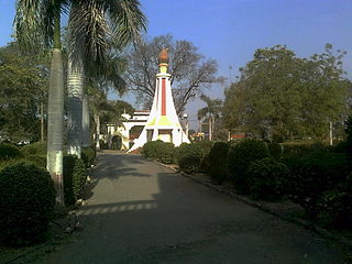
Kamla Nehru Prani Sangrahalaya or Indore Zoo is a zoological garden located in Navlakha, Indore is managed by Indore Municipal Corporation. Indore zoo is the only zoo to deploy online booking, animal-health app, and touchless entry system that is tightly integrated with e-Nagarpalika, making it the most advanced zoo of India.
Khandwa Naka is a sub-urb in the largest city and commercial hub Indore in the state of Madhya Pradesh, India.
Kamla Nagar is a locality in Agra City in Uttar Pradesh, India. It has PIN Code 282004, and is an approved colony. . Kamla Nagar is named after Kamala Nehru, a freedom fighter and wife of Jawaharlal Nehru, India's first prime minister. Kamla Nagar is a residential and commercial neighborhood in North Agra, India. It is one of Agra's major Posh Colony, good for shopping and eating.