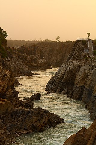
The Narmada River, previously also known as Narbada or anglicised as Nerbudda, is the 5th longest river in India and overall the longest west-flowing river in the country. It is also the largest flowing river in the state of Madhya Pradesh. This river flows through the states of Madhya Pradesh and Gujarat in India. It is also known as the "Lifeline of Madhya Pradesh and Gujarat" due to its huge contribution to the two states in many ways. The Narmada River rises from the Amarkantak Plateau in Anuppur district in Madhya Pradesh. It forms the traditional boundary between North and South India and flows westwards for 1,312 km (815.2 mi) before draining through the Gulf of Khambhat into the Arabian Sea, 30 km (18.6 mi) west of Bharuch city of Gujarat.

Pachmarhi is a hill station in the Hoshangabad district of Madhya Pradesh state of central India. It has been the location of a cantonment since the British Raj. The municipality is located in a valley of the Satpura Range and is widely known as Satpura ki Rani.

The Satpura Range is a range of hills in central India. The range rises in eastern Gujarat running east through the border of Maharashtra and Madhya Pradesh and ends in Chhattisgarh. The range parallels the Vindhya Range to the north, and these two east–west ranges divide Indian Subcontinent into the Indo-Gangetic plain of northern India and the Deccan Plateau of the south. The Narmada River originates from north-eastern end of Satpura in Amarkantak, and runs in the depression between the Satpura and Vindhya ranges, draining the northern slope of the Satpura range, running west towards the Arabian Sea. The Tapti River originates in the eastern-central part of Satpura, crossing the range in the center and running west at the range's southern slopes before meeting the Arabian Sea at Surat, draining the central and southern slopes of the range. Multai, the place of Tapi river origin is located about 465 kilometer far, south-westerly to Amarkantak, separated across by the hill range. The Godavari River and its tributaries drain the Deccan plateau, which lies south of the range, and the Mahanadi River drains the easternmost portion of the range. The Godavari and Mahanadi rivers flow into the Bay of Bengal. At its eastern end, the Satpura range meets the hills of the Chotanagpur Plateau. The Satpura Range is a horst mountain and is flanked by Narmada Graben in the north and much smaller but parallel Tapi Graben in the south.

Hoshangabad, officially Narmadapuram, is a city in the Indian state of Madhya Pradesh. It serves as the headquarters of both Hoshangabad district and Narmadapuram division. It is located in central India, on the south bank of the Narmada River. Hoshangabad is 76.7 km (47.7 mi) from the capital of Madhya Pradesh and the nearest airport Bhopal.
The Pachmarhi Biosphere Reserve is a non-use conservation area and biosphere reserve in the Satpura Range of Madhya Pradesh state in Central India.

The Tawa River is a tributary of the Narmada River of Central India.
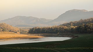
Satpura Tiger Reserve (STR) also known as Satpura National Park is located in the Narmadapuram district of Madhya Pradesh in India. Its name is derived from the Satpura range. It covers an area of 524 km2 (202 sq mi). Satpura National Park, along with the adjoining Bori and Pachmarhi wildlife sanctuaries, provides 2,200 km2 (850 sq mi) of unique central Indian highland ecosystem. It was set up in 1981.

The Upper Gangetic Plains moist deciduous forests is a tropical and subtropical moist broadleaf forests ecoregion of northern India.

The Eastern Highlands moist deciduous forests, presently known as East Deccan moist deciduous forests, is a tropical and subtropical moist broadleaf forests ecoregion in east-central India. The ecoregion covers an area of 341,100 square kilometers (131,700 sq mi), extending across portions of Andhra Pradesh, Chhattisgarh, Jharkhand, Madhya Pradesh, Maharashtra, Odisha, and Telangana states.
Sanjay National Park is a national park in Manendragarh-Chirmiri-Bharatpur district of Chhattisgarh and Singrauli district of Madhya Pradesh, India. It covers an area of 2,300 km2 (890 sq mi) and is a part of the Sanjay-Dubri Tiger Reserve. It is located in the Narmada Valley dry deciduous forests ecoregion.

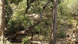
The Narmada Valley dry deciduous forests are a tropical dry forest ecoregion of central India. The ecoregion lies mostly in Madhya Pradesh state, but extends into portions of Chhattisgarh, Maharashtra, Karnataka and Uttar Pradesh states.
The Central Deccan Plateau dry deciduous forests in Western and Southern India, containing large protected areas of natural tiger habitat.
Tourism in Madhya Pradesh has been an attraction of India because of its location in the centre of the country. Madhya Pradesh has won Best Tourism State National award for 3 consecutive years i.e. 2017, 2016 and 2015.

Pench Tiger Reserve or Pench National Park is one of the premier tiger reserves of India and the first one to straddle across two states - Madhya Pradesh and Maharashtra. The reference to Pench is mostly to the tiger reserve in Madhya Pradesh.

Madhya Pradesh, often called the Heart of India, is a state in central India. Its capital is Bhopal. Madhya Pradesh was originally the largest state in India until November 1, 2000 when the state of Chhattisgarh was carved out. It borders the states Uttar Pradesh, Chhattisgarh, Maharashtra, Gujarat and Rajasthan.

Satkosia Tiger Reserve is a tiger reserve located in the border of Angul and Nayagarh district of Odisha, India covering an area of 988.30 km².
Shoolpaneshwar Wildlife Sanctuary is a protected area in India's Gujarat state, located in the western Satpura Range south of the Narmada River and is 607.7 km2 (234.6 sq mi) large. It shares a common boundary with Madhya Pradesh and Maharashtra. It encompasses mixed dry deciduous forest, riverine forest, few pockets of moist teak forest, agricultural fields and two water reservoirs. It was established in 1982.
The Achanakmar-Amarkantak Biosphere Reserve is a biosphere reserve in India that extends across the states of Madhya Pradesh and Chhattisgarh, covering a total area of 383,551 hectares (3835.51 km2).
Pench National Park is a national park in India's Madhya Pradesh state, established in 1975 with an area of 257.26 km2 (99.33 sq mi). It includes Pench Tiger Reserve and derives its name from the Pench River that flows through the park from north to south dividing the park into almost equal western and eastern halves, the well-forested areas of Seoni and Chhindwara districts respectively. It was declared a sanctuary in 1965, raised to the status of national park in 1975 and enlisted as a tiger reserve in 1992. In 1983 it was declared as National Park.
Tawa Nagar is a town in Madhya Pradesh state of India. It is located in near Itarsi Junction in Narmadapuram district. Itarsi is a key hub for agricultural goods and is the biggest, oldest & the busiest railway junctions in Madhya Pradesh. Rail services from all 4 major metropolitan cities of India namely Mumbai to Calcutta and Delhi to Chennai pass through Itarsi. It has Ordnance Factory Itarsi of the Ordnance Factories Board which manufactures products for the Indian Armed Forces. The Bori Wildlife Sanctuary and Tawa Dam are nearby.
