
Himachal Pradesh is a state in the northern part of India. Situated in the Western Himalayas, it is one of the thirteen mountain states and is characterised by an extreme landscape featuring several peaks and extensive river systems. Himachal Pradesh is the northernmost state of India and shares borders with the union territories of Jammu and Kashmir and Ladakh to the north, and the states of Punjab to the west, Haryana to the southwest, Uttarakhand to the southeast and a very narrow border with Uttar Pradesh to the south. The state also shares an international border to the east with the Tibet Autonomous Region in China. Himachal Pradesh is also known as Dev Bhoomi or Dev Bhumi, meaning 'Land of Gods' and Veer Bhoomi which means 'Land of the Brave'.

Kullu is a district in Himachal Pradesh, India. It borders Shimla district to the south, Mandi and Kangra districts to the west, Kinnaur to the east and the Lahaul and Spiti district to the north and east. The largest valley in this mountainous district is the Kullu Valley. The Kullu valley follows the course of the Beas River, and ranges from an elevation of 833 m above sea level at Aut to 3330 m above sea level at the Atal Tunnel South Portal, below the Rohtang Pass. The town of Kullu, located on the right side of the Beas River, serves as the administrative headquarters of the Kullu district. The Kullu district also incorporates several riverine tributary valleys of the Beas, including those of the Parvati, Sainj, and Tirthan rivers, and thus some regions somewhat distant from the Kullu valley. The economy of the district relies mainly on horticulture, agriculture, tourism, and traditional handicrafts.

The Lahaul and Spiti district in the Indian state of Himachal Pradesh consists of the two formerly separate districts of Lahaul and Spiti. The present administrative center is Kyelang in Lahaul. Before the two districts were merged, Kardang was the capital of Lahaul, and Dhankar the capital of Spiti. The district was formed in 1960 and is the fourth least populous district in India. It is the least densely populated district of India, according to the Census of India 2011.

Manali is a town, near Kullu town in Kullu district in the Indian state of Himachal Pradesh. It is situated in the northern end of the Kullu Valley, formed by the Beas River. The town is located in the Kullu district, approximately 270 kilometres (170 mi) north of the state capital of Shimla and 544 kilometres (338 mi) northeast of the national capital of New Delhi. With a population of 8,096 people recorded in the 2011 Indian census Manali is the beginning of an ancient trade route through Lahaul (H.P.) and Ladakh, over the Karakoram Pass and onto Yarkand and Hotan in the Tarim Basin of China. Manali is a popular tourist destination in India and serves as the gateway to the Lahaul and Spiti district as well as the city of Leh in Ladakh.

Kinnaur district is one of the twelve administrative districts of the state of Himachal Pradesh in northern India. The district is divided into three administrative areas and has six tehsils. The administrative headquarters of the district is at Reckong Peo. The revered Kinnaur Kailash mountain, one of the Panch Kailash sites, is situated in Kinnaur. As of 2011, it is the second least populous district of Himachal Pradesh, after Lahaul and Spiti.
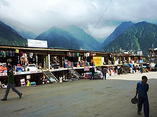
Reckong Peo, also spelled Rekong Peo or simply known as Peo by the local inhabitants, is headquarters of Kinnaur district, one of the twelve administrative districts of the Indian state of Himachal Pradesh.

Kullu is a municipal council town that serves as the administrative headquarters of the Kullu district of the Indian state of Himachal Pradesh. It is located on the banks of the Beas River in the Kullu Valley about 10 kilometres (6.2 mi) north of the airport at Bhuntar, Kullu.

The Pir Panjal Range is a range of mountains in the Lower Himalayan region located in the Western Himalayas of northern Indian subcontinent. It runs southeast to northwest between the Beas and Neelam/Kishanganga rivers, in the Indian state of Himachal Pradesh and Indian-administered union territory of Jammu and Kashmir, with its northwestern end extending into territory administered by Pakistan. The Himalayas show a gradual elevation towards the Dhauladhar and Pir Panjal ranges. Pir Panjal is the largest and westernmost range of the Lesser Himalayas. Near the bank of the Sutlej River, it dissociates itself from the main Himalayan range and forms a divide between the Beas and Ravi rivers on one side and the Chenab on the other. Further west, the Pir Panjal range forms the southwestern boundary of the Kashmir Valley, separating it from the hills of Jammu region, forming a divide between the Jhelum and Chenab rivers.

Shimla district is one of the twelve districts of the state of Himachal Pradesh in northern India. Its headquarters is the state capital of Shimla. Neighbouring districts are Mandi and Kullu in the north, Kinnaur in the east, Uttarakhand in the southeast, Solan to the southwest and Sirmaur in the south. The elevation of the district ranges from 987 metres (3,238 ft) to 4,500 metres (14,764 ft).

The state of Himachal Pradesh is spread over an area 55,673 km2 (21,495 sq mi) and is bordered by Jammu and Kashmir and Ladakh on the north, Punjab on the southwest, Haryana on the south, Uttarakhand on the southeast, a small border with Uttar Pradesh in the south, and Tibet on the east. Entire Himachal Pradesh lies in the mountainous Himalaya region, rich in natural resources

Baspa Valley is a river valley that is said to be named after the Baspa River. It lies in the Kinnaur District of Himachal Pradesh, India. Sangla is a major town in the Baspa Valley, and the valley is also known as the Sangla Valley or Tukpa Valley. The villages inside the valley is Chitkul, Rakchham, Batseri, Sangla, Kamru; the old capital of Bushahr State and Chansu.

Spiti is a high-altitude region of the Himalayas, located in the north-eastern part of the northern Indian state of Himachal Pradesh. The name "Spiti" means "The middle land", i.e. the land between Tibet and India. Spiti incorporates mainly the valley of the Spiti River, and the valleys of several rivers that feed into the Spiti River. Some of the prominent side-valleys in Spiti are the Pin valley and the Lingti valley. Spiti is bordered on the east by Tibet, on the north by Ladakh, on the west and southwest by Lahaul, on the south by Kullu, and on the southeast by Kinnaur. Spiti has a cold desert environment. The valley and its surrounding regions are among the least populated regions of India. The Bhoti-speaking local population follows Tibetan Buddhism.
Himachal Pradesh, although railways and airways serve very limited transport needs, the road network of the state serves the transport needs of the people. Although, the geography of Himachal presents considerable challenge to the development of transport infrastructure, it has the highest road density among all the Hill States of India. Himachal also has 3 airports, 2 narrow gauge rail tracks and couple of other under-construction broad gauge railway tracks, but roads remain the main mode of transport.

Bhrigu Lake or Brighu Lake is a lake located at an elevation of around 4,300 metres (14,100 ft) in Kullu district, Himachal Pradesh, India. It is located to the east of Rohtang Pass and is around 6 kilometres (3.7 mi) from Gulaba village. It can be reached by trekking either from Vashisht temple, which is famous for its hot water springs, close to the town of Manali. It is named after Maharishi Bhrigu.

Kasol is a hamlet in the Kullu district of the Indian state of Himachal Pradesh. It is situated in Parvati Valley, on the banks of the Parvati River between Bhuntar and Manikaran. It is located 30 km (19 mi) from Bhuntar, 3.5 km from Manikaran and 36 km (22 mi) from Kullu town, the district headquarters. Kasol is the Himalayan hotspot for backpackers and acts as a base for nearby treks to Malana and Kheerganga. It is called Mini Israel of India due to a high percentage of Israeli tourists here.

Karsog is a town and municipal area in the state of Himachal Pradesh in northern India.

Himachal Road Transport Corporation, also referred to as HRTC, is the state-owned road transport corporation of the state of Himachal Pradesh, India. HRTC provides bus services to towns and cities within Himachal Pradesh and the adjoining and nearby states of Uttarakhand, Punjab, Haryana, Delhi, Uttar Pradesh, Jammu and Kashmir and Rajasthan. HRTC is one of the first RTC's in India to offer a facility for online booking of tickets for all types of buses.
The Western Himalayas refers to the western half of the Himalayas, in northwestern India and northern Pakistan. Four of the five tributaries of the Indus River in Punjab rise in the Western Himalayas; while the fifth, the Sutlej cuts through the range after rising in Tibet.

Bhaba Pass, also known as Bhawa Pass, is a high mountain pass situated in the northern Indian state of Himachal Pradesh in the Indian Himalayas. It is located on the border of Kinnaur district and Lahaul and Spiti District, and borders Pin Valley National Park and the Rupi-Bhaba Wildlife Sanctuary.


