Erode District is one of the 38 districts in the state of Tamil Nadu in India. It was the largest district by area in the state before the formation of Tirupur District in 2009. The headquarters of the district is Erode. It is divided into two revenue divisions, Erode and Gobichettipalayam, and is further subdivided into 10 taluks. Erode District was a part of Coimbatore District before its division into two on 17 September 1979. It covers an area of 5,722 square kilometres (2,209 sq mi), and as of 2011, had a population of 2,251,744.

Namakkal is a city and the headquarters of Namakkal district, Tamil Nadu. It is the first ISO 14001-2004 certified municipality in Asia for environmental management, specifically the provision and maintenance of water supply, solid waste and sewage management, town planning, lighting and other social services. Namakkal is known as the Egg City due to its large egg production and Transport city.

Tenkasi is a town and headquarters of the Tenkasi district in Indian state of Tamil Nadu.

Thindukkalalso spelt, Dindigul, is a city in the Indian state of Tamil Nadu. It is the administrative headquarters of the Dindigul district. Dindigul is located 420 km (260 mi) southwest from the state capital, Chennai, 100 km (62 mi) away from Tiruchirappalli, 105 km (65 mi) away from Karaikudi, 66 km (41 mi) away from Madurai and 72 km away from the Tex City of Karur. The city is known for its locks and biryani. Parts of Dindigul Districts like Palani, Oddanchatram, Vedasandur, Nilakottai, Kodaikanal, Natham, Athoor.

Madurai district is one of the 38 districts of the state of Tamil Nadu in southeastern India. The city of Madurai serves as the district headquarters. It houses the famous Sri Meenakshi Sundareshwarar temple and is situated on the banks of the river Vaigai. Thiruparankundram is one of the major tourist place in the district. As of 2011, the district had a population of 3,038,252 with a sex-ratio of 990 females for every 1,000 males. Aside from the city of Madurai, the larger towns are Melur, Vadipatti, Thirumangalam, Thirupparankundram, Peraiyur, and Usilampatti. It is an important hub for various film shootings. Alanganallur is a popular spot in the district for Jallikattu, as are Palamedu and Avaniyapuram.
Palani (Tamil:[paɻani], is a town and a taluk headquarters in Dindigul district of the western part of Tamil Nadu state in India. It is located about 106 kilometres south-east of Coimbatore and 122 kilometres north-west of Madurai, 67 kilometres from Kodaikanal. The Palani Murugan Temple or Arulmigu Dhandayuthapani Swamy Temple, dedicated to Murugan is situated on a hill overlooking the town. The temple is visited by more than 7 million pilgrims each year. As of 2011, the town had a population of 70,467 and the Taluk had a population of 292,301 which makes it the second largest town in the district after Dindigul.
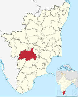
Karur District is one of the 38 districts in the Indian state of Tamil Nadu. The main town in Karur District is the city of Karur, which is also the district headquarters. The district has a population of 1,064,493 with a sex-ratio of 1,015 females for every 1,000 males, according to 2011 census.
Pollachi is a town and municipality in Coimbatore district of the Indian state of Tamil Nadu. It is the administrative headquarters of Pollachi taluk. It is situated near the center of the South Indian Peninsula, surrounded by Western Ghats. Agriculture and textile industries contribute majorly to the economy of the town and the town is a popular marketplace for jaggery, vegetables and cattle.
Rasipuram is a Municipality in the Indian state of Tamil Nadu. It is the headquarters for the Rasipuram taluk. As of 2015, the town had a population of 88,584 and an area of 24 km2 (9.3 sq mi). It has 27 wards and steps have been taken to increase the wards to 33. Rasipuram is known for ghee and tapioca sago.

Dharapuram is a town situated along the banks of Amaravati River in Tiruppur district in the Indian state of Tamil Nadu. Dharapuram is one of the oldest towns in South India and was the capital of Kongu Nadu under the Cheras, Western Ganga Dynasty and later Kongu Cholas, at which time it was known as Viradapuram. Amaravathi River flows through the town. As of 2011, the town had a population of 67,007. The city houses famous temples including Agatheeswarar Temple, Kaadu Hanumanthasamy temple and many others.

Oddanchatram is town in the Dindigul district of Tamil Nadu. The town was carved out of Madurai District in 1985. Oddanchatram has the second largest Vegetable market in Tamil Nadu and a large Cattle market. As of 2011, the town had a population of 30,064. It is known as the vegetable city of Tamil Nadu. Almost 70% of the vegetables from this market is sent to Kerala and remaining is sent to other states. Agriculture is the major economy for the town. The town was once a small village under the Aanda Nadu(one of the 24 counties of kongu Nadu). This constituency along with palani is historically a part of the kongu region distinguishes itself from the rest of the district interms of culture and food.
Kangeyam is a historical town and municipality in Kangeyam Taluk of Tiruppur district in the Indian state of Tamil Nadu. It is situated on National Highway 81. Kangeyam is an economic center in Tamil Nadu. The main commercial interests of the municipality are rice hulling, coconut oil extraction, ghee production, and groundnut cultivation. The town is located 28 km from the district headquarters at Tiruppur, 45 km from the city of Erode, 70 km from the industrial town of Coimbatore,30 km from the town of Dharapuram, 55 km from the city of Karur, 140 km from the Ancient city of Trichy and 441 km from the state capital Chennai.

Manapparai is a municipality in Tiruchirappalli district in the Indian state of Tamil Nadu. Manapparai Town is located 38 km from Trichy. Manapparai is the headquarters of the Manapparai Taluk. Manapparai is famous for murukku and cattle market. As of 2011, the town had a population of 40,510.

Udumalai, also known as Udumalaipettai and Udumalpet, is a town in Tiruppur district in the Indian state of Tamil Nadu. It is located 535 km south west from the state capital, Chennai and 72 km from Coimbatore. It is the headquarters of Udumalaipettai taluk and had a population of 61,133 as per 2011 Census of India. The town comes under the Udumalaipettai Assembly constituency.

Valparai is a Taluk and hill station in the Coimbatore district of Tamil Nadu, India. It consists of Anamalai Tiger Reserve. It is located 3,474 feet (1,059 m) above sea level on the Anaimalai Hills range of the Western Ghats. There are a total of 56 estates here. The game of football is very popular here. State level competitions are held every year. The foothill starts exactly from Monkey Falls which is at a distance of 38 kilometres (24 mi) to Valparai. The route to Valparai from the foothills consists of 40 hairpin bends. The Kerala state border town of Malakkappara is at a distance of 27 kilometres from Valparai. While major portions of the land are owned by private tea companies, large forest areas continue to be out of bounds.
Vellakovil is a municipal town in Kangeyam taluk of Tirupur District, in the Indian state of Tamil Nadu. It is located on National Highway 81 between Trichy and Coimbatore. The town is spread in an area of 64.75 km2. As of 2011, the town had a population of 40,359. Kannapuram village located near to this town is famous for Kangeyam breed cattle market that happens on every year during Mariyamman temple festival in the month of April. It is an industrialized town with traditional agriculture being the occupation for most of the people. It holds lot of Power looms weaving bedsheets, floor mats and cotton materials being exported to foreign countries via exporters present in Karur.

Sengottai is a town in the Tenkasi district, of Tamil Nadu, India. It is the gateway to southern Tamil Nadu and Kerala. Spread over an area of 2.68 km2 with a population of over 26,823, the economy of the town and Sengottai Taluk revolves around the cultivation of rice,coconut,Mango,clove and pepper. Sengottai is well known in Tamil Nadu as a major market of Dosa kal. This town has lot of Black smith shops.
Tiruppur District is one of the 38 districts of the Indian state of Tamil Nadu, formed in 22 February 2009. Dharapuram was the largest taluk by area in the district. The district is well-developed and industrialized. The Tiruppur banian industry, the cotton market, Kangeyam bull and Uthukkuli butter, among other things, provide for a vibrant economy. The city of Tiruppur is the administrative headquarters for the district. As of 2011, the district had a population of 2,479,052 with a sex-ratio of 989 females for every 1,000 males.
Tamil Nadu is one of the 28 states of India. Its capital and largest city is Chennai. Tamil Nadu lies in the southernmost part of the Indian Peninsula and is bordered by the States of Puducherry, Kerala, Karnataka and Andhra Pradesh. It is the tenth-largest state in India and the seventh most populous state.

Tiruvannamalai district is the second largest district in Tamil Nadu by area after Dindigul District and one of the 38 districts in the state of Tamil Nadu, in South India. It was formed in the year 1989 through the bifurcation of North Arcot into the Tiruvannamalai Sambuvarayar and Vellore Ambedkar districts. The city of Tiruvannamalai is the district headquarters.