Ariyalur district

Last updated


Ariyalur District
Gangaikondacholapuram Temple 4.jpg
Busy Noon Day in Bus Stand Road, Jayankondam.jpg
coolllkngkm eeri.jpg
Ariyalur perumal temple.jpg
Tirumalapadi17.jpg
Brihadiswara Temple at Gangaikonda Cholapuram, bus stand road in Jayankondam, Cholagangam Lake, Kodandaramaswamy Temple, Ariyalur, Thirumazhapadi Siva Temple
Nickname: 
Cement city
Ariyalur in Tamil Nadu (India).svg
Location in Tamil Nadu
Ariyalur district
Ariyalur district
Coordinates: 11°08′13″N79°04′33″E / 11.13704°N 79.075821°E / 11.13704; 79.075821
Country Flag of India.svg  India
State TamilNadu Logo.svg Tamil Nadu
Headquarters Ariyalur
Taluks Ariyalur,
Sendurai,
Udayarpalayam,
Andimadam
Government
   District Collector P. Ramana Saraswathi, IAS [1]
   Superintendent of Police K. Feroze Khan Abdullah [2]
Area
  Total1,949.31 km2 (752.63 sq mi)
Population
 (2011) [3]
  Total754,894
  Density390/km2 (1,000/sq mi)
Languages
  Official Tamil
Time zone UTC+5:30 (IST)
Vehicle registration TN 61
Website ariyalur.nic.in

Ariyalur district is an administrative district, one of the 38 districts in the state of Tamil Nadu in India. The district headquarters is located at Ariyalur. The district encompasses an area of 1,949.31 km2.

Contents

Gangaikonda Cholapuram, built by King Rajendra Cholan of Chola Empire, is a UNESCO World Heritage Site situated in this district. The district is also known for its rich prehistoric fossils. Many fossils of gigantic molluscs and jawed fishes, at least one fossilized dinosaur egg, and several fragmentary fossils of sauropod and theropod dinosaurs have been discovered here. [4] [5] [6] An on-site museum is being set up at Keelapazhur to preserve and conserve fossils. [7] Ariyalur is noted for its cement industries and Jayankondam has huge reserves of lignite. [8]

History

In 1995, Tiruchirappalli was trifurcated and the Perambalur and Karur districts were formed. Ariyalur district was carved out of Perambalur district on 1 January 2001. But, it was merged with Perambalur district on 31 March 2002. Ariyalur district was re-carved on 23 November 2007. The district is bordered by the districts of Cuddalore to the north and north-east, Mayiladuthurai to the east, Thanjavur to the south and south-east, Tiruchirapalli to the south-west and Perambalur to the west.[ citation needed ]

Brihadeeswarar Temple, Gangaikondacholapuram

Brihadisvara Temple at Gangaikonda Cholapuram is a Hindu temple dedicated to Shiva in Gangaikonda Cholapuram, Jayankondam, in the South Indian state of Tamil Nadu. Completed in 1035 CE by Rajendra Chola I as a part of his new capital, this Chola dynasty era temple is similar in design, and has a similar name, as the older 11th century, Brihadeeswarar Temple about 70 km (43 mi) to the southwest in Thanjavur. The Gangaikonda Cholapuram Temple is smaller yet more refined than the Thanjavur Temple. Both are among the largest Shiva temples in South India and examples of Dravidian style temples.

Demographics

Religions in Ariyalur district (2011) [9]
ReligionPercent
Hinduism
93.84%
Christianity
4.95%
Islam
1.05%
Other or not stated
0.16%

According to the 2011 census, Ariyalur district has a population of 754,894, [10] roughly equal to the nation of Guyana [11] or the US state of Alaska. [12] This gives it a ranking of 491 in India (out of a total of 640). [10] The district has a population density of 387 inhabitants per square kilometre (1,000/sq mi) . [10] Its population growth rate over the decade 2001–2011 was 8.19%. [10] Ariyalur has a sex ratio of 1016 females for every 1000 males, [10] and a literacy rate of 71.99%. 11.01% of the population lives in urban areas. [10] Scheduled Castes and Scheduled Tribes make up 23.34% and 1.42% of the population, respectively. As of 2011 it is the third least populous district of Tamil Nadu (out of 32), after Perambalur and Nilgiris. [10] Jayankondam is the most populated town in Ariyalur district. Tamil is the predominant language, spoken by 99.27% of the population. [13]

Historical population
YearPop.±% p.a.
1901271,501    
1911294,621+0.82%
1921306,764+0.40%
1931308,837+0.07%
1941348,381+1.21%
1951398,231+1.35%
1961437,692+0.95%
1971513,704+1.61%
1981572,498+1.09%
1991636,381+1.06%
2001695,524+0.89%
2011754,894+0.82%
source: [14]

Politics

Source: [15] [16]
DistrictNo.ConstituencyNamePartyAllianceRemarks
Ariyalur 149 Ariyalur K. Chinnappa Dravida Munnetra Kazhagam (MDMK) SPA
150 Jayankondam Ka. So. Ka. Kannan Dravida Munnetra Kazhagam SPA

Notable locations

Transportation

Ariyalur is well connected to the neighborhood districts of Thanjavur, Thiruchirappalli, Perambalur and Cuddalore via road. Tamil Nadu State Transport Corporation operates buses regularly to neighborhood cities.

The Ariyalur railway station is one of the prominent station which is located on the Chord Line. Ariyalur is connected to Chennai Egmore railway station.

See also

Related Research Articles

<span class="mw-page-title-main">Thanjavur</span> Historical city in Tamil Nadu, India - சோழனின் சொர்க்க பூமி

Thanjavur, also known as Thanjai, previously known as Tanjore, is a city in the Indian state of Tamil Nadu. It is the 11th biggest city in Tamil Nadu. Thanjavur is an important center of southern Indian religion, art, and architecture. Most of the Great Living Chola Temples, which are UNESCO World Heritage Monuments, are located in and around Thanjavur. The foremost among these, the Brihadeeswara Temple, built by the Chola emperor Rajaraja I, is located in the centre of the city. This temple has one of the largest bull statue in India carved out of a single granite rock called Nandi. Thanjavur is also home to Tanjore painting, a painting style unique to the region. Thanjavur is the headquarters of the Thanjavur District. The city is an important agricultural centre located in the Kaveri Delta and is known as the Rice bowl of Tamil Nadu. Thanjavur is administered by a municipal corporation covering an area of 36.31 km2 (14.02 sq mi) and had a population of 222,943. Roadways are the major means of transportation, while the city also has rail connectivity. The nearest airport is Tiruchirapalli International Airport, located 59.6 km (37.0 mi) away from the city. The nearest seaport is Karaikal, which is 94 km (58 mi) away from Thanjavur. The city first rose to prominence during the reign of the Cholas when it served as the capital of the empire. After the fall of the Cholas, the city was ruled by various dynasties such as the Mutharaiyar dynasty, the Pandyas, the Vijayanagar Empire, the Madurai Nayaks, the Thanjavur Nayaks, the Thanjavur Marathas and the British Empire. It has been a part of independent India since 1947.

<span class="mw-page-title-main">Gangaikonda Cholapuram</span> Town in Tamil Nadu, India

Gaṅgaikoṇḍa Chōḻapuram is a village located near to Jayankondam, Ariyalur district, Tamil Nadu, India. It became the capital of the Chola dynasty in c. 1025 by Chola emperor Rajendra I, and served as the capital for around 250 years.

<span class="mw-page-title-main">Bharathidasan University</span> Public university in Trichy, India

Bharathidasan University (BDU) is a university in the city of Tiruchirappalli, Tamil Nadu, India. It is located on Tiruchirappalli-Pudukkottai National Highway 336. It has affiliated colleges in the districts of Ariyalur district, Karur, Nagapattinam, Perambalur, Pudukkottai, Thanjavur, Tiruvarur and Tiruchirapalli. It is a recognised university, supported by the University Grants Commission of India. All major faculties of science and arts are represented. The university has totally 4 Faculties, 16 Schools, 37 Departments and 29 Specialized Research Centres.

<span class="mw-page-title-main">Rajendra I</span> Chola emperor from 1014–1044

Rajendra I, often referred to as Rajendra the Great, Gangaikonda Cholan, and Kadaram Kondan, was a Chola Emperor who reigned from 1014 and 1044 CE. He was born in Thanjavur to Rajaraja I and his queen Vanavan Mahadevi and assumed royal power as co-regent with his father in 1012 until his father died in 1014, when Rajendra ascended to the Chola throne. During his reign, the Chola Empire reached its zenith in the Indian subcontinent; it extended its reach via trade and conquest across the Indian Ocean, making Rajendra one of only a few Indian monarchs who conquered territory beyond South Asia.

<span class="mw-page-title-main">Chola Nadu</span> Region of Tamil Nadu

Chola Nadu is a cultural region of the Tamil Nadu state in southern India. It encompasses the lower reaches of the Kaveri River and its delta, and formed the cultural homeland and political base of the Chola Dynasty which ruled large parts of South India and parts of Sri Lanka between the 9th and 13th centuries CE. Uraiyur served as the early Chola capital, then medieval Cholas shifted to Thanjavur and later cholas king Rajendra Chola I moved the capital to Gangaikonda Cholapuram in Ariyalur in the 11th century CE.

<span class="mw-page-title-main">Great Living Chola Temples</span> UNESCO World Heritage Site in Tamil Nadu, India

The Great Living Chola Temples is a UNESCO World Heritage Site designation for a group of Chola dynasty era Hindu temples in the Indian state of Tamil Nadu. The temple at Thanjavur was added in the list in 1987, while the other two temples were added in 2004.

<span class="mw-page-title-main">Tiruchirappalli district</span> District of Tamil Nadu in India

Tiruchirappalli District is one of the 38 districts, located along the Kaveri River, in Tamil Nadu, India. The headquarters of the district is the city of Tiruchirappalli.

<span class="mw-page-title-main">Jayankondam</span> First Grade Municipality in Tamil Nadu, India

Jayankondam is a First Grade Municipality in Ariyalur district of Tamil Nadu in India. As of 2023, the town had a population of 46,000.

<span class="mw-page-title-main">Lalgudi</span> Town in India

Lalgudi is a Municipality in Tiruchirapalli district in the Indian state of Tamil Nadu. The town of Lalgudi heads the Lalgudi taluk, Lalgudi division, Lalgudi Educational District, Lalgudi DSP and Lalgudi Constituency.

<span class="mw-page-title-main">Thuraiyur</span> Municipality in Tamil Nadu, India

Thuraiyur is a municipality in the Tiruchirappalli district in the Indian state of Tamil Nadu. It was upgraded to a III Grade Municipality from Town Panchayat on 17 January 1970, and to a II Grade Municipality in May 1998. It was upgraded to Selection Grade Municipality in the year 2008. It is also a taluka. It is located 310 km away from Chennai.

<span class="mw-page-title-main">Udayarpalayam</span> Town Panchayat in Tamil Nadu, India

Udayarpalayam is a panchayat town in the Ariyalur district of the Indian state of Tamil Nadu, near Jayankondam.

<span class="mw-page-title-main">Ariyalur</span> Town in Tamil Nadu, India

Ariyalur is a town and district headquarters of Ariyalur district in the South Indian state of Tamil Nadu and is rich in limestone, surrounded with seven cement factories and two sugar factories. The town is located at a distance of 310 km (190 mi) from the state capital Chennai.

<span class="mw-page-title-main">Pazhayarai</span> Ancient Chola capital city

Pazhayarai or Pazhaiyarai or Palayarai was an ancient capital of the medieval Chola dynasty in Tamil Nadu. The place is located around 7 km (4.3 mi) from Kumbakonam, a city in Thanjavur district, in the South Indian state of Tamil Nadu. It is located on the banks of T.Patnam river, one of the distributaries of the river Kaveri. There are a number of villages within the area of historic Pazhaiyarai. The place was called Ayiratalli, meaning a land of thousand temples. The place is referred under various names like Ayiratalli, Pazhayar, Ahavamallakulakalapuram and Minavanaivenkadasolapuram.

Udayarpalayam taluk is a taluk of Ariyalur district of the Indian state of Tamil Nadu. The headquarters of the taluk is the town of Jayankondam.

Veeramudaiyanatham is a village in Cuddalore district in the Indian state of Tamil Nadu.It is located in near the vallaru(white river),25 km from chidambaram; 23 km from virudhachalam; 80 km from Pondicherry.

The Trichinopoly district was a district of the erstwhile Madras Presidency of British India. It covered the present-day districts of Tiruchirappalli, Karur, Ariyalur and Perambalur in the Indian state of Tamil Nadu. The administrative headquarters was the town of Trichinopoly, Trichy or Tiruchi, now known as Tiruchirappalli. The district covered an area of 2,632 square miles (6,820 km2) in 1907. It was bound by the districts of South Arcot to the north, Salem to the west, Coimbatore to the west and north-west, Tanjore to the east and Madurai to the south. The princely state of Pudukkottai remained within the jurisdiction of Trichinopoly district from 1865 to 1947.

<span class="mw-page-title-main">Architecture of Tamil Nadu</span> Overview of the architecture of Tamil Nadu

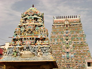
Tamil Nadu is known for its ancient temple architecture. Nearly 33,000 ancient temples, many at least 800 to 2000 years old, are found scattered all over Tamil Nadu. As per Tamil Nadu Hindu Endowments Board, there are 38,615 temples. Most of the largest Hindu Temples reside here. Studded with complex architecture, a variety of sculptures, and rich inscriptions, the temples remain the very essence of the culture and heritage of Tamil land, with historical records dating back to at least 3,000 years.

Kaiperambalur is a panchayat village of the Kizhamathdur district in Perambalur, Tamil Nadu, India. It was formally part of the Tiruchirappalli district.

<span class="mw-page-title-main">Brihadisvara Temple, Gangaikonda Cholapuram</span> Brohadisvara temple is known as Gangaikonda cholapuram

The Brihadisvara Temple is a Hindu temple dedicated to Shiva in Gangaikonda Cholapuram, Jayankondam, in the South Indian state of Tamil Nadu. Completed in 1035 AD by Rajendra Chola I as a part of his new capital, this Chola dynasty era temple is similar in design, and has a similar name, as the older 11th century, Brihadeeswarar Temple about 70 kilometres (43 mi) to the southwest in Thanjavur. The Gangaikonda Cholapuram Temple is smaller yet more refined than the Thanjavur Temple. Both are among the largest Shiva temples in South India and examples of Dravidian style temples. The temple is also referred to in texts as Gangaikonda Cholapuram Temple or Gangaikondacholeeswaram Temple

References

  1. "New Collector takes charge in Ariyalur". The Hindu. 13 July 2017 via www.thehindu.com.
  2. "I-Day celebrations held in Ariyalur and Karur". www.thehindu.com. The Hindu. 15 August 2022. Retrieved 20 November 2022.
  3. "2011 Census of India" (Excel). Indian government. 16 April 2011.
  4. Nainar, Nahla (29 March 2019). "A trip through the fossil-rich grounds of Ariyalur in Tamil Nadu". The Hindu. ISSN   0971-751X . Retrieved 8 April 2019.
  5. Goswami, A.; Prasad, G. V. R.; Verma, O.; Flynn, J. J.; Benson, R. B. J. (16 April 2013). "A troodontid dinosaur from the latest Cretaceous of India". Nature Communications. 4 (1): 1703. Bibcode:2013NatCo...4.1703G. doi: 10.1038/ncomms2716 . ISSN   2041-1723. PMID   23591870.
  6. "From the lost world". The Hindu. 24 February 2016. ISSN   0971-751X . Retrieved 6 March 2016.
  7. "With rare collection of fossils, Ariyalur museum in Tamil Nadu nearing completion". 5 February 2018.[ dead link ]
  8. "Ariyalur district". ariyalur.nic.in.
  9. "Table C-01 Population by Religion: Tamil Nadu". censusindia.gov.in. Registrar General and Census Commissioner of India. 2011.
  10. 1 2 3 4 5 6 7 "District Census 2011". Census2011.co.in. 2011. Retrieved 30 September 2011.
  11. US Directorate of Intelligence. "Country Comparison:Population". Archived from the original on 13 June 2007. Retrieved 1 October 2011. Guyana 744,768
  12. "2010 Resident Population Data". U. S. Census Bureau. Archived from the original on 19 October 2013. Retrieved 30 September 2011. Alaska 710,231
  13. "Table C-16 Population by Mother Tongue: Tamil Nadu". Census of India . Registrar General and Census Commissioner of India.
  14. Decadal Variation In Population Since 1901
  15. "Tamil Nadu Election Results 2021: Here's full list of winners". CNBCTV18. 3 May 2021. Retrieved 22 December 2023.
  16. "Tamil Nadu Election Results 2021: Full list of winners". www.indiatvnews.com. 2 May 2021. Retrieved 22 December 2023.
  17. "Places of Interest | Ariyalur District, Government of Tamil Nadu | Land of Cements" . Retrieved 8 April 2019.