A caldera is a large cauldron-like hollow that forms shortly after the emptying of a magma chamber in a volcano eruption. When large volumes of magma are erupted over a short time, structural support for the rock above the magma chamber is gone. The ground surface then collapses into the emptied or partially emptied magma chamber, leaving a large depression at the surface. Although sometimes described as a crater, the feature is actually a type of sinkhole, as it is formed through subsidence and collapse rather than an explosion or impact. Compared to the thousands of volcanic eruptions that occur each century, the formation of a caldera is a rare event, occurring only a few times per century. Only seven caldera-forming collapses are known to have occurred between 1911 and 2016. More recently, a caldera collapse occurred at Kīlauea, Hawaii in 2018.
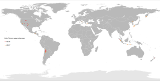
A supervolcano is a volcano that has had an eruption with a Volcanic Explosivity Index (VEI) of 8, the largest recorded value on the index. This means the volume of deposits for such an eruption is greater than 1,000 cubic kilometers.

A volcano is a rupture in the crust of a planetary-mass object, such as Earth, that allows hot lava, volcanic ash, and gases to escape from a magma chamber below the surface.

Mount St. Helens is an active stratovolcano located in Skamania County, Washington, in the Pacific Northwest region of the United States. It lies 52 miles (83 km) northeast of Portland, Oregon, and 98 miles (158 km) south of Seattle. Mount St. Helens takes its English name from that of the British diplomat Lord St Helens, a friend of explorer George Vancouver who surveyed the area in the late 18th century. The volcano is part of the Cascade Volcanic Arc, a segment of the Pacific Ring of Fire.

Mayon, also known as Mount Mayon and Mayon Volcano, is an active stratovolcano in the province of Albay in Bicol, Philippines. A popular tourist spot, it is renowned for its "perfect cone" because of its symmetric conical shape, and is regarded as sacred in Philippine mythology.
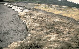
A lahar is a violent type of mudflow or debris flow composed of a slurry of pyroclastic material, rocky debris and water. The material flows down from a volcano, typically along a river valley.

A shield volcano is a type of volcano named for its low profile, resembling a warrior's shield lying on the ground. It is formed by the eruption of highly fluid lava, which travels farther and forms thinner flows than the more viscous lava erupted from a stratovolcano. Repeated eruptions result in the steady accumulation of broad sheets of lava, building up the shield volcano's distinctive form.

A magma chamber is a large pool of liquid rock beneath the surface of the Earth. The molten rock, or magma, in such a chamber is less dense than the surrounding country rock, which produces buoyant forces on the magma that tend to drive it upwards. If the magma finds a path to the surface, then the result will be a volcanic eruption; consequently, many volcanoes are situated over magma chambers. These chambers are hard to detect deep within the Earth, and therefore most of those known are close to the surface, commonly between 1 km and 10 km down.

Iceland experiences frequent volcanic activity, due to its location both on the Mid-Atlantic Ridge, a divergent tectonic plate boundary, and over a hot spot. Nearly thirty volcanoes are known to have erupted in the Holocene epoch; these include Eldgjá, source of the largest lava eruption in human history.

In volcanology, a lava dome is a circular, mound-shaped protrusion resulting from the slow extrusion of viscous lava from a volcano. Dome-building eruptions are common, particularly in convergent plate boundary settings. Around 6% of eruptions on Earth are lava dome forming. The geochemistry of lava domes can vary from basalt to rhyolite although the majority are of intermediate composition The characteristic dome shape is attributed to high viscosity that prevents the lava from flowing very far. This high viscosity can be obtained in two ways: by high levels of silica in the magma, or by degassing of fluid magma. Since viscous basaltic and andesitic domes weather fast and easily break apart by further input of fluid lava, most of the preserved domes have high silica content and consist of rhyolite or dacite.

Mount Takahe is a 3,460-metre-high (11,350 ft) snow-covered shield volcano in Marie Byrd Land, Antarctica, 200 kilometres (120 mi) from the Amundsen Sea. It is a c. 30-kilometre-wide (19 mi) mountain with parasitic vents and a caldera up to 8 kilometres (5 mi) wide. Most of the volcano is formed by trachytic lava flows, but hyaloclastite is also found. Snow, ice, and glaciers cover most of Mount Takahe. With a volume of 780 km3 (200 cu mi), it is a massive volcano; the parts of the edifice that are buried underneath the West Antarctic Ice Sheet are probably even larger. It is part of the West Antarctic Rift System along with eighteen other known volcanoes.
Pavlof Volcano is a stratovolcano of the Aleutian Range on the Alaska Peninsula. It has been one of the most active volcanoes in the United States since 1980, with eruptions recorded in 1980, 1981, 1983, 1986–1988, 1996–1997, 2007, 2013, twice in 2014, 2016, and is currently erupting as of August 2021. Basaltic andesite with SiO2 around 53% is the most common lava type. The volcano is monitored by the Alaska Volcano Observatory- a joint program of the United States Geological Survey (USGS), the Geophysical Institute of the University of Alaska Fairbanks (UAFGI), and the State of Alaska Division of Geological and Geophysical Surveys (ADGGS). With a threat score of 95, the threat from future eruptions is considered to be high; much of this threat comes from the possibility of disruption of nearby air routes by large releases of ash. The mountain currently has basic real-time monitoring, but the USGS would like to improve instrumentation at the site. The mountain shares a name with the nearby Pavlof Sister, which last erupted in 1786.

Bazman is a dormant stratovolcano in a remote desert region of Sistan and Baluchestan Province in south-eastern Iran. A 500-m-wide crater caps the summit of the dominantly andesitic-dacitic volcano, the flanks of which are covered by monogenetic centres especially to the northwest. Bazman is a geologically young volcano which formed mainly in the Quaternary, with the oldest dated rocks being 11.7 million years old and the youngest 0.6 million years. Although no historic eruptions have been reported from Bazman, it does contain fumaroles. Thus Bazman may be regarded as dormant, rather than extinct. Its satellite cones have been the source of basaltic lava flows.

Submarine volcanoes are underwater vents or fissures in the Earth's surface from which magma can erupt. Many submarine volcanoes are located near areas of tectonic plate formation, known as mid-ocean ridges. The volcanoes at mid-ocean ridges alone are estimated to account for 75% of the magma output on Earth. Although most submarine volcanoes are located in the depths of seas and oceans, some also exist in shallow water, and these can discharge material into the atmosphere during an eruption. The total number of submarine volcanoes is estimated to be over one million of which some 75,000 rise more than 1 kilometre (0.62 mi) above the seabed. Only 119 submarine volcanoes in Earth's oceans and seas are known to have erupted during the last 11,700 years.

Lava lakes are large volumes of molten lava, usually basaltic, contained in a volcanic vent, crater, or broad depression. The term is used to describe both lava lakes that are wholly or partly molten and those that are solidified.

Corcovado Volcano is a stratovolcano located about 25 kilometres (16 mi) south of the mouth of the Yelcho River, in the Palena Province, Los Lagos Region, Chile. The glacially eroded volcano is flanked by Holocene cinder cones. The volcano's base has likely prehistoric lava flows that are densely vegetated. The most distinctive feature of this volcano is its stepped top, similar to that of Puntiagudo Volcano. At its foot lies a series of lakes. Corcovado dominates the landscape of the Gulf of Corcovado area and is visible from Chiloé Island, weather permitting.

Several types of volcanic eruptions—during which lava, tephra, and assorted gases are expelled from a volcanic vent or fissure—have been distinguished by volcanologists. These are often named after famous volcanoes where that type of behavior has been observed. Some volcanoes may exhibit only one characteristic type of eruption during a period of activity, while others may display an entire sequence of types all in one eruptive series.

A cinder cone is a steep conical hill of loose pyroclastic fragments, such as volcanic clinkers, volcanic ash, or scoria that has been built around a volcanic vent. The pyroclastic fragments are formed by explosive eruptions or lava fountains from a single, typically cylindrical, vent. As the gas-charged lava is blown violently into the air, it breaks into small fragments that solidify and fall as either cinders, clinkers, or scoria around the vent to form a cone that often is symmetrical; with slopes between 30 and 40°; and a nearly circular ground plan. Most cinder cones have a bowl-shaped crater at the summit.