Shimoga

Last updated

Shimoga
Shivamogga
Indian Lion at Tyavarekoppa Tiger and Lion Reserve, Karnataka, India.jpg
Shivappanayaka (cropped).jpg
Sculpture of Mahishasura Mardhini dated to the 12th century.JPG
Shivappa Nayaka Palace and garden.JPG
Images, from top down, left right
Indian lion in the Tyavarekoppa Tiger and Lion Reserve
Statue of Keladi Shivappa Nayaka
Sculpture of Mahishasura Mardhini
Shivappa Nayaka palace
India Karnataka location map.svg
Red pog.svg
Shimoga
India location map.svg
Red pog.svg
Shimoga
Coordinates: 13°56′N75°34′E / 13.933°N 75.567°E / 13.933; 75.567
Country India
State Karnataka
District Shimoga
Region Malenadu
Government
  TypeCity Corporation
  BodyShivamogga Mahanagara Palike
Area
   City 70.01 km2 (27.03 sq mi)
  Rural
1,037.29 km2 (400.50 sq mi)
Elevation
569 m (1,867 ft)
Population
 (2011) [2]
   City 322,650
  Rank10th (Karnataka)
  Density4,600/km2 (12,000/sq mi)
   Rural
184,674
Languages
  Official Kannada
Time zone UTC+5:30 (IST)
PIN
577201 - 577205
Telephone code 91-(0)8182-XXXXXX
ISO 3166 code IN-KA
Vehicle registration KA-14
Climate Aw
Website shivamoggacitycorp.org/WebsiteSHMG/Citizen/index.aspx

Shimoga, officially Shivamogga, [3] is a city and the district headquarters of Shimoga district in the central part of the state of Karnataka, India. The city lies on the banks of the Tunga River. Being the gateway for the hilly region of the Western Ghats, the city is popularly nicknamed the "Gateway of Malnad". [4] The population of Shimoga city is 322,650 as per 2011 census. [2] The city has been selected for the Smart Cities project, standing in the fourth position in the state and 25th in the country as of November 2020. [5]

Contents

The city is 569 m above sea level and is surrounded by lush green paddy fields, arecanut and coconut groves. It is located 267 km from the state capital Bangalore and 195 km from the port city Mangalore. [6]

History

The name of the city is derived from the term shivmoga. A version of the etymology is the story that Shiva drank the Tunga River hence the name "Shiva-Mukha" which means the "face of Shiva". Another version of the etymology is that the name is derived from the term Sihi-Mogge, meaning "sweet pot". [7]

The district formed the southern tip of the Emperor Ashoka's Mauryan Empire in the third century BC.[ citation needed ] It was ruled during later centuries by the Kadambas (4th century), Chalukyas (6th century), Western Ganga, Rashtrakutas (8th century), Hoysalas (11th century), and the Vijayanagara rulers (15th century). Nayakas of Keladi , also known as Nayakas of Bednore and Ikkeri Nayakas, were an Indian dynasty based in Keladi in present-day Shimoga district of Karnataka, India. They were an important ruling dynasty in late medieval and early modern Karnataka. They initially ruled as a vassal of the famous Vijayanagar Empire. After the fall of the empire in 1565, they gained independence and ruled significant parts of Malnad region of the Western Ghats in present-day Karnataka, most areas in the coastal regions of Karnataka, and parts of northern Kerala, Malabar and the central plains along the Tungabhadra river. In 1763 AD, with their defeat to Hyder Ali, they were absorbed into the Kingdom of Mysore. [8]

During the Satyagraha movement, Mahatma Gandhi also visited the place to instigate the fight for national freedom. [6] After the independence of India in 1947, the Mysore state merged into the Republic of India.

On 1 November 2006, the government of Karnataka announced the renaming of Shimoga to "Shivamogga", along with nine other cities in the state. The central government approved (12 cities) the request in the October 2014 and the city was renamed on 1 November 2014. [9] [10] [11] [12]

Geography

According to the Shimoga City Municipal Corporation, [13] the city has a total area of about 50 square kilometres (19 sq mi). As per the Smart City Proposal, of the total city area (around 70.01 km2), 11.28% area is under OS & green belts while 7% is under water cover. [14] Most/all these hills are part of the Western Ghats, a region known for plentiful rainfall and lush greenery and declared during 2012 as a World Heritage site. Tunga River flows through Shimoga. The river is the major source of drinking water in the city and the city gets its drinking water through the Tunga dam (also known as Gajanuru dam). [15]

Climate

The climate is tropical wet and dry (Köppen climate classification) summer average temperature 20–35 °C (68–95 °F). This means that the winter and the early part of summer are typically dry periods. The majority of the rainfall occurs between June and early October. Shimoga is a part of a region known as Malnad (land of hills) in Karnataka. The average annual rainfall of the city is 731.1mm. [16] January and February are the driest months, July the wettest, and April is the warmest month with an average high temperature of 35.5 degrees Celsius (95.9 degrees F). Coldest months of Shimoga are July, August, November and December with average high temperature of 27 degrees Celsius (80.6 degrees F). [16] In summer (April–May), temperature crosses 36 °C at Shimoga. [17]

Climate data for Shimoga (1981–2010, extremes 1950–2005)
MonthJanFebMarAprMayJunJulAugSepOctNovDecYear
Record high °C (°F)35.0
(95.0)
38.8
(101.8)
41.4
(106.5)
39.7
(103.5)
44.0
(111.2)
40.0
(104.0)
34.7
(94.5)
35.0
(95.0)
38.0
(100.4)
35.0
(95.0)
34.4
(93.9)
34.0
(93.2)
44.0
(111.2)
Mean daily maximum °C (°F)31.5
(88.7)
33.6
(92.5)
36.0
(96.8)
36.4
(97.5)
34.9
(94.8)
30.1
(86.2)
28.2
(82.8)
27.8
(82.0)
29.6
(85.3)
30.4
(86.7)
30.1
(86.2)
30.0
(86.0)
31.6
(88.9)
Mean daily minimum °C (°F)15.3
(59.5)
16.5
(61.7)
19.5
(67.1)
21.5
(70.7)
22.2
(72.0)
21.5
(70.7)
20.9
(69.6)
20.5
(68.9)
20.3
(68.5)
20.2
(68.4)
18.2
(64.8)
15.8
(60.4)
19.3
(66.7)
Record low °C (°F)6.5
(43.7)
9.0
(48.2)
11.7
(53.1)
11.5
(52.7)
15.0
(59.0)
16.0
(60.8)
15.7
(60.3)
13.0
(55.4)
11.5
(52.7)
11.7
(53.1)
8.0
(46.4)
6.0
(42.8)
6.0
(42.8)
Average rainfall mm (inches)0.2
(0.01)
0.3
(0.01)
5.9
(0.23)
34.8
(1.37)
41.1
(1.62)
109.0
(4.29)
158.2
(6.23)
129.0
(5.08)
70.8
(2.79)
140.4
(5.53)
30.4
(1.20)
11.2
(0.44)
731.1
(28.78)
Average rainy days0.00.10.42.43.28.411.912.75.36.31.90.753.3
Average relative humidity (%) (at 17:30 IST)42403643537478797369594858
Source: India Meteorological Department [18] [19]

Demographics

As of 2011 Indian Census, Shimoga had a total population of 322,650, of which 162,018 were males and 160,632 were females. Population within the age group of 0 to 6 years was 32,691. The total number of literates in Shimoga was 254,531, which constituted 78.9% of the population with male literacy of 81.4% and female literacy of 76.3%. The effective literacy rate of 7+ population of Shimoga was 87.8%, of which male literacy rate was 90.8% and female literacy rate was 84.8%. The Scheduled Castes and Scheduled Tribes population was 40,737 and 9,192 respectively. Shimoga had 76,009 households in 2011. [2]

Religions in Shimoga City (2011) [20]
ReligionPercent
Hinduism
72.76%
Islam
23.93%
Christianity
2.17%
Jainism
0.82%
Other or not stated
0.32%
Distribution of religions

Kannada is the most widely spoken language in Shimoga. 72.76% of people are Hindus and 23.93% are Muslims, with rest being Buddhists, Christians and others. [20]

Languages of Shimoga City (2011 census) [21]

   Kannada (53.47%)
   Urdu (23.47%)
   Tamil (6.75%)
   Telugu (5.91%)
   Hindi (3.14%)
   Marathi (2.93%)
   Konkani (2.28%)
   Malayalam (0.93%)
  Others (1.12%)

Kannada is the majority language, spoken by 53.47% of the population. Urdu is the second-largest language, while Tamil, Telugu, Hindi, Marathi and Konkani are also spoken. [21]

Government and politics

Civic administration

Shimoga is governed by a Municipal Corporation called the Shivamogga City Corporation. The total area under it is 70.01 km2 (27.03 sq mi), with a population of 322,650 (Census 2011). [22] Shimoga has been selected under the Smart Cities Mission of the Indian Government under Round 2 of selections. [23] Shimoga was upgraded to a Municipal Corporation from a Municipal Council in 2013. [24]

Economy

RMC Yard, Shimoga R M C Yard, Shimoga.JPG
RMC Yard, Shimoga

APMC of Shimoga is main marketing point of arecanut, the major commercial crop grown in the district and well as in neighbouring districts like Uttara Kannada. Shimoga has the biggest areca nut market, and known for procuring high quality areca nuts. Other agricultural produces like rice, Maize, chili, coconut etc. are also marketed in APMC.

Shimoga IT Park is an information technology hub built just outside Shimoga near the upcoming Shimoga Airport. The IT Park consists of a 100000 sq ft office building with 24/7 electrical capacity, diesel backup generators, and high speed T1 data connections for use by IT industries such as data centres, call centres, aerospace, robotics, etc. [25]

spar mall Spar mall.jpg
spar mall
city centre mall shimoga City centre mall shimoga.jpg
city centre mall shimoga

Transportation

KSRTC Bus Stand Ksrtcshimoga.jpg
KSRTC Bus Stand

Road

Shimoga is well connected by road to major cities like Bangalore, Mysore,Mangalore, Hubli, Davangere, bellary. Two major National Highways pass through the city. NH69 and NH169

Rail

The city has two railway stations, main one being Shivamogga Town Railway Station, and there are trains that run to and from Bangalore, Mysore, Tirupati and Chennai.

Air

Shimoga Airport is situated near Sogane, 13 km south of Shimoga. This is the first airport which is being operated by Karnataka State Industrial & Infrastructure Development Corporation Limited as a wholly owned and undertaking of Government of Karnataka and not handed over to Airport Authority of India. [26] [27] The nearest international airports are Kempegowda International Airport and Mangalore International Airport.

Education

Shimoga is one of the important centers for the high school and the pre-university education in Karnataka. Notable institutes in Shimoga for high school is Jnanadeepa school and for pre-university (PU) education include: Sri Aurobindo PU College and PACE PU College and PES college in outskirts of city.

The village of Gajanur hosts a Jawahar Navodaya Vidyalaya (central school) which is a boarding school. Kuvempu University is located in Shankarghatta, at a distance of 20 km from Shimoga.

Shimoga Institute of Medical Sciences is the medical sciences college at Shimoga and managed by Government Departments. Subbaiah Institute of Medical Sciences is located at Purale. [28] It also has two engineering colleges, Jawaharlal Nehru National College of Engineering and PES Institute of Technology and Management.Also Rastriya Raksha University, Shivamogga Campus is opened in Ragigudda near Navule

Notable people

See also

Related Research Articles

<span class="mw-page-title-main">Karnataka</span> State in southern India

Karnataka, also known colloquially as Karunāḍu, is a state in the southwestern region of India. It was formed as Mysore State on 1 November 1956, with the passage of the States Reorganisation Act, and renamed Karnataka in 1973. The state is bordered by the Lakshadweep Sea to the west, Goa to the northwest, Maharashtra to the north, Telangana to the northeast, Andhra Pradesh to the east, Tamil Nadu to the southeast, and Kerala to the southwest. With 61,130,704 inhabitants at the 2011 census, Karnataka is the eighth-largest state by population, comprising 31 districts. The state was part of the Carnatic region in British terminology. With 15,257,000 residents, the state capital Bangalore is the fourth-most populated city in India.

<span class="mw-page-title-main">Uttara Kannada</span> District of Karnataka, India

Uttara Kannada is a district in the Indian state of Karnataka. It is a major coastal district of Karnataka, and is the third largest district in Karnataka. It is bordered by the state of Goa and Belagavi districts to the north, Dharwad District and Haveri District to the east, Shivamogga District, and Udupi District to the south, and the Laccadive Sea to the west.

<span class="mw-page-title-main">Dakshina Kannada</span> District of Karnataka in India

Dakshina Kannada district is located in the state of Karnataka in India, with its headquarters in the coastal city of Mangalore. It is part of the larger Tulu Nadu region. The district covers an area nestled in between the Western Ghats to its east and the Arabian Sea to its west. Dakshina Kannada receives abundant rainfall during the Indian monsoon. It is bordered by Udupi district to the north, Chikmagalur district to the northeast, Hassan district to the east, Kodagu to the southeast and Kasaragod district of Kerala to the south. According to the 2011 census of India, Dakshina Kannada district had a population of 2,083,625. It is the only district in Karnataka state to have all modes of transport like road, rail, water and air due to the presence of a major hub, Mangalore. This financial district is also known as the Cradle of Indian banking.

<span class="mw-page-title-main">Malenadu</span> Region in Karnataka, India

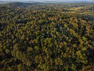
Malnad is a region in the state of Karnataka, India. Malenadu covers the western and eastern slopes of the Western Ghats mountain range and is roughly 100 kilometers in width. The region experiences heavy annual rainfall of 1,000–3,800 millimetres ; it includes the village of Agumbe, which receives the highest annual rainfall in Karnataka.

<span class="mw-page-title-main">Davanagere</span> City in Karnataka, India

Davanagere is a city in the centre of the southern Indian state of Karnataka. It is the seventh largest city in the state, and the administrative headquarters of eponymous Davangere district. Hitherto being a cotton hub and hence popularly known before as the Manchester of Karnataka, the commercial ventures of the city is now dominated by education and agro-processing industries. Davanagere became a separate district in 1997, when it was separated from the erstwhile undivided district of Chitradurga for administration conveniences. Davanagere is known for rich culinary traditions which encompass the diversity of entire Karnataka's dishes due to its geographical position in the state as its centre. Notable among them is its aromatic benne dose.

<span class="mw-page-title-main">Mysore division</span> Administrative division in Karnataka, India

Mysore division, officially Mysuru division, is an administrative division in the southern Indian state of Karnataka. It is one of four administrative divisions in Karnataka, the others being Bangalore division, Belagavi division, and Kalaburagi division. Mysore division comprises eight districts of Karnataka, namely, Chamarajanagar, Chikmagalur, Dakshina Kannada, Hassan, Kodagu, Mandya, Mysore and Udupi district. The city of Mysore is the administrative headquarters of the division. Mysore division covers parts of historical Old Mysore region and southern part of Coastal Karnataka.The total area of the division is 43,503 sq.km. The total population as of 2011 census is 12,563,598.

<span class="mw-page-title-main">Bhadravati, Karnataka</span> City in Karnataka, India

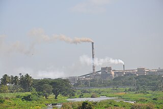
Bhadravati or Bhadravathi is an industrial city or Steel Town and taluk in the Shivamogga District of the Indian state of Karnataka. It is situated at a distance of about 255 kilometres (158 mi) from the state capital Bengaluru and at about 20 kilometres (12 mi) from the district headquarters, Shivamogga. The town is spread over an area of 67.0536 square kilometres (25.8895 sq mi) and has a population of 151,102 as per the census held in 2011.

<span class="mw-page-title-main">Chikmagalur</span> City in Karnataka, India

Chikmagalur is a city and the headquarters of Chikmagalur district in the Indian state of Karnataka. Located on the foothills of the Mullayanagiri peak of the Western Ghats, the city attracts tourists from around the world for its pleasant and favourable hill station climate, tropical rainforest and coffee estates. The pristine Baba Budangiri lies to the north of Chikmagalur where it's believed Baba Budan first introduced coffee to India.

<span class="mw-page-title-main">Hassan district</span> District of Karnataka in India

Hassan is one of the 31 districts of Karnataka, India. The district headquarter is Hassan. It was carved out from Mysore district in the year 1866, during the Commissioner's Rule of Mysore (1831-81).

<span class="mw-page-title-main">Kaduru</span> Town in Karnataka, India

Kaduru, also known as Kadur, is second largest town in the district and a Taluk in Chikmagalur district, in Karnataka. It is located at 13.553345°N 76.011260°E in the rain shadow region of western ghats. Most of the taluk is dry, unlike much of the district. Kadur is known for Areca nut and also Coconut production.

<span class="mw-page-title-main">Sirsi, Karnataka</span> City in Karnataka, India

Sirsi is a city and a taluk headquarter in Uttara Kannada district of Karnataka state in India. It was also known as Kalyana Pattana during the Sonda Dynasty. It is a tourist destination with evergreen forest and waterfalls and is also a commercial centre. The main businesses around the city are mostly subsistence and agriculture-based. Areca nut or betel nut, locally known as Adike, is the primary crop grown in the nearby villages, making it one of the major trading centres for areca nut. The region is also known for spices such as cardamom, pepper, betel leaves, and vanilla. The major food crop is paddy.

<span class="mw-page-title-main">Dharwad district</span> District of Karnataka in India

Dharwad or Dharawada is an administrative district of the state of Karnataka in southern India. The administrative headquarters of the district is the city of Dharwad, also known as Dharwar. Dharwad is located 425 km northwest of Bangalore and 421 km southeast of Pune, on the main highway between Chennai and Pune, the National Highway 4 (NH4).

<span class="mw-page-title-main">Shimoga district</span> District of Karnataka in India

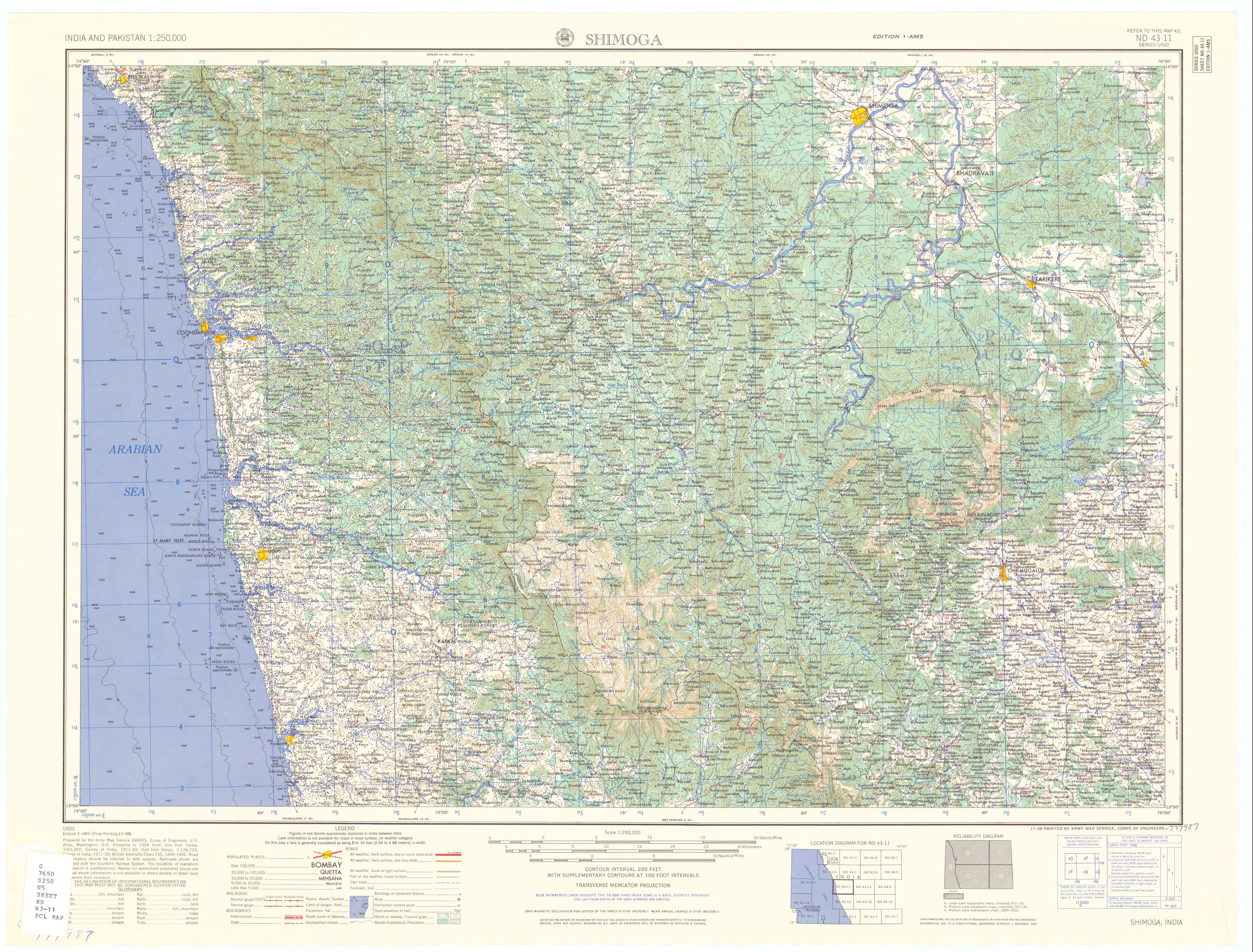
Shimoga district, officially known as Shivamogga district, is a district in the Karnataka state of India. A major part of Shimoga district lies in the Malnad region or the Sahyadri. Shimoga city is its administrative centre. Jog Falls view point is a major tourist attraction. As of 2011 Shimoga district has a population of 17,52,753. There are seven taluks: Soraba, Sagara, Hosanagar, Shimoga, Shikaripura, Thirthahalli, and Bhadravathi. Channagiri and Honnali were part of Shimoga district until 1997 when they became part of the newly formed Davanagere district.

<span class="mw-page-title-main">Tumkur</span> City in Karnataka, India

Tumkur is a city located in the southern part of Indian state of Karnataka. It is situated at a distance of 70 km (43 mi) northwest of Bangalore, the state's largest city and capital, along NH 48 and NH 73. It is the headquarters of the Tumakuru district. It is located at an altitude of 835 m (2739.5 ft).

Hosanagara is a panchayat town in Shimoga district in the Indian state of Karnataka. It is nested in western ghats of India. The World Cattle Conference with main emphasis on cow was held in month of April 2007 in Hosanagar. The different uses of cow were exhibited. Near Hosanagar there is a mutt named Sri Ramachandrapura Math, 6 km from the town.

Tarikere is a taluk in the Chikmagalur district in the state of Karnataka of India. The headquarters of the taluk is a town of the same name. It is popularly known as gateway of Malnad because the Malnad area starts from here. The town's name is derived from the number of water tanks which surround it.

<span class="mw-page-title-main">Nayakas of Keladi</span> Ruling dynasty in Karnataka, India (1499–1763)

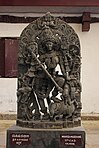
Nayakas of Keladi (1499–1763), also known as Nayakas of Bednore and Ikkeri Nayakas, were an Indian dynasty based in Keladi in present-day Shimoga district of Karnataka, India. They were an important ruling dynasty in post-medieval Karnataka. They initially ruled as a vassal of the famous Vijayanagar Empire. After the fall of the empire in 1565, they gained independence and ruled significant parts of Malnad region of the Western Ghats in present-day Karnataka, most areas in the coastal regions of Karnataka and the central plains along the Tungabhadra river. In 1763 AD, with their defeat to Hyder Ali, they were absorbed into the Kingdom of Mysore. They played an important part in the history of Karnataka, during a time of confusion and fragmentation that generally prevailed in South India after the fall of the Vijayanagar Empire. The Keladi rulers were of the Vokkaliga and Banajiga castes and were Veerashaivas by faith. The Haleri Kingdom that ruled over Coorg between 1600 A.D and 1834 A.D. was founded by a member of the Keladi family.

<span class="mw-page-title-main">Hulikal</span> Village in Karnataka, India

Hulikal is a village located in the Hosanagara taluk of the Shimoga district in the Indian state of Karnataka and is known for its heavy rainfall. The Hulikal village lies in western ghat region of Karnataka state. The range of ghat is known by the name Hulikal ghat or Balebare ghat. The road running between Hosangadi and Mastikatte through Hulikal ghati connects coastal district of Udupi with Shivamogga district. The Mani dam reservoir and Savehoklu reservoir are nearby. KPCL has its colony at Mastikatte near to Hulikal. The nearest airport is at Mangalore, situated 123 km south-west of Hulikal. It has an elevation of 600m.

<span class="mw-page-title-main">Sagara, Karnataka</span> City in Karnataka, India

Sagara is a city located in the Indian state of Karnataka. It is also a sub divisional and a taluk headquarters. Located in the Sahyadri Mountain range on the banks of river Varada, it is known for its proximity to Jog Falls and to the historical places of Ikkeri, Keladi and Varadamoola. The river Varada originates near Varada-moola. Sagara subdivision consists of Sagara, Soraba, Hosanagara and Shikaripur taluks.

<span class="mw-page-title-main">University of Agricultural and Horticultural Sciences, Shimoga</span> University in Karnataka, India

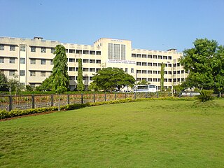
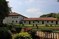
The Keladi Shivappa NayakaUniversity of Agricultural and Horticultural Sciences, Shimoga(KSNUAHS) is a university in the Indian state of Karnataka. It is the state's first integrated university to have both agricultural and horticultural sciences under its purview.

References

  1. "About Our District - Shivamogga". District Urban Development Cell, Shivamogga - Official Website of Directorate of Municipal Administration. Retrieved 24 November 2023.
  2. 1 2 3 4 "Census of India: Shimoga". www.censusindia.gov.in. Retrieved 5 December 2019.
  3. "Bangalore becomes 'Bengaluru'; 11 other cities renamed". The Economic Times . PTI. 1 November 2014. Retrieved 18 July 2018.
  4. "85 per cent unused funds leaves Shivamogga scruffy". The New Indian Express. 6 May 2018. Retrieved 23 February 2021.
  5. "Push to complete Smart City project works on time". The Hindu. 24 November 2020. Retrieved 12 February 2021.
  6. 1 2 "Shimoga | Shivamogga | Sightseeing Shimoga | Wildlife Shimoga". Karnataka.com. 18 August 2016. Retrieved 10 April 2020.
  7. "History of Shivamogga". Shivamogga District. National Informatics Centre, Ministry of Electronics & Information Technology, Government of India. Archived from the original on 4 August 2020. Retrieved 8 December 2020.
  8. Buchanan, Francis; Hamilton, Francis (1988). A journey from Madras through the ... – Google Books. Asian Educational Services. ISBN   9788120603868 . Retrieved 17 September 2011.
  9. "Bangalore, Mysore, Other Karnataka Cities to be Renamed on 1 November". International Business Times . 18 October 2014. Retrieved 18 July 2018.
  10. K. Jeevan Chinnappa (18 October 2014). "Centre nod for Karnataka's proposal on renaming cities". The Hindu. Retrieved 18 July 2018.
  11. "It's Bengaluru for Pranab". The Times of India. 7 July 2009. Retrieved 18 July 2018.
  12. Nagesh Prabhu. "New name for cities". The Hindu. Retrieved 18 July 2018.
  13. "Shimoga Municipal corporation" . Retrieved 18 July 2018.
  14. City, Smart (28 February 2023). "SmartCityProposal_KA-03-SMG" (PDF). Smartnet. Retrieved 28 February 2023.
  15. Chronicle, Deccan (2 July 2019). "Inflow of Tunga river in Karnataka rises after heavy rainfall in Western Ghats". Deccan Chronicle. Retrieved 28 February 2023.
  16. 1 2 "Shimoga, India - Detailed climate information and monthly weather forecast". Weather Atlas. Retrieved 10 April 2020.
  17. "Shimoga weather". World Weather Online. Retrieved 18 July 2018.
  18. "Station: Shimoga Climatological Table 1981–2010" (PDF). Climatological Normals 1981–2010. India Meteorological Department. January 2015. pp. 705–706. Archived from the original (PDF) on 5 February 2020. Retrieved 19 April 2020.
  19. "Extremes of Temperature & Rainfall for Indian Stations (Up to 2012)" (PDF). India Meteorological Department. December 2016. p. M103. Archived from the original (PDF) on 5 February 2020. Retrieved 19 April 2020.
  20. 1 2 "Table C-01 Population by Religion: Karnataka". censusindia.gov.in. Registrar General and Census Commissioner of India. 2011.
  21. 1 2 "Table C-16 Population by Mother Tongue (Town): Karnataka". www.censusindia.gov.in. Registrar General and Census Commissioner of India.
  22. "Shivamogga City Corporation". shivamoggacitycorp.org. Retrieved 10 April 2020.
  23. "City Wise Projects under Smart Cities Mission :: SMART CITIES MISSION, Government of India". smartcities.gov.in. Retrieved 10 April 2020.
  24. "Tumkur, Shimoga and Bijapur cities to be upgraded as Municipal Corporations". The Hindu. 2 September 2013. Retrieved 10 April 2020.
  25. Veerendra, P. M. (26 May 2014). "Two years on, Shimoga Information Technology Park awaits entrepreneurs". The Hindu. ISSN   0971-751X.
  26. "Shivamogga on aviation map as PM to inaugurate airport today". The New Indian Express. 27 February 2023. Retrieved 28 February 2023.
  27. "Airport at Shimoga likely to come up at Sogane". The Hindu. 8 April 2006. ISSN   0971-751X.
  28. "Contact Us". Subbaiah Institute of Medical Science. Retrieved 18 July 2018.