
Shimoga, officially Shivamogga, is a city and the district headquarters of Shimoga district in the Karnataka state of India. The city lies on the banks of the Tunga River. Being the gateway for the hilly region of the Western Ghats, the city is popularly nicknamed the "Gateway of Malnad". The population of Shimoga city is 322,650 as per 2011 census. The city has been selected for the Smart Cities project, standing in the fourth position in the state and 25th in the country as of November 2020.

Talakaveri or Talacauvery is the place that is generally considered to be the source of the river Kaveri and a holy place for many Hindus. It is located on Brahmagiri hills near Bhagamandala in Kodagu district (Coorg), in the South Indian state of Karnataka. It is located close to the border with Kasaragod district, Kerala. Talakaveri stands at a height of 1,276 meters above sea level. Despite its traditional status as the source of the Kaveri, there is no permanent visible flow from this place to the main rivercourse, except during the monsoon rains.
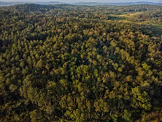
Malnad is a region in the state of Karnataka, India. Malenadu covers the western and eastern slopes of the Western Ghats mountain range and is roughly 100 kilometers in width. It includes the districts of Uttara Kannada, Chikmagalur, Chamarajanagar, Udupi, Belgaum, Dakshina Kannada, Hassan, Kodagu, Shimoga. The region experiences heavy annual rainfall of 1,000–3,800 millimetres ; it includes the village of Agumbe, which receives the highest annual rainfall in Karnataka.
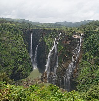
Jog Falls is a waterfall on the Sharavati river located in Siddapur taluk of Uttara Kannada district and its view point in Kargal town of Shimoga district, Karnataka, India. It is the second highest plunge waterfall in India. It is a segmented waterfall which depends on rain and season to become a plunge waterfall. The falls are major attractions for tourists and is ranked 36th in the list of free-falling waterfalls, 490th in the world by list of waterfalls by total height, 128th in the list of single-drop waterfalls in the World by the waterfall database.

Kodachadri is a mountain peak with dense forests in the Western Ghats in South India, 78 km from Shimoga. Kodachadri is the highest peak in Shivamogga district. It is declared as natural heritage site by the Karnataka Government. and it is 13th highest peak of Karnataka.

Sharavati is a river which originates and flows entirely within the state of Karnataka in India. It is one of the few westward flowing rivers of India and a major part of the river basin lies in the Western Ghats. The famous Jog Falls, located about 25 km from Siddapura, is formed by this river. The river itself and the regions around it are rich in biodiversity and are home to many rare species of flora and fauna.

Agumbe is a village situated in the Thirthahalli taluka of Shivamogga district, Karnataka, India. It is nestled in the thickly forested Malenadu region of the Western Ghats mountain range. Owing to its high rainfall, it has received the epithet of "The Cherrapunji of South India", after Cherrapunji, one of the rainiest places in India.
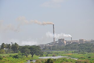
Bhadravati or Bhadravathi is an industrial city or Steel Town and taluk in the Shivamogga District of the Indian state of Karnataka. It is situated at a distance of about 255 kilometres (158 mi) from the state capital Bengaluru and at about 20 kilometres (12 mi) from the district headquarters, Shivamogga. The town is spread over an area of 67.0536 square kilometres (25.8895 sq mi) and has a population of 151,102 as per the census held in 2011.

Shimoga district, officially known as Shivamogga district, is a district in the Karnataka state of India. A major part of Shimoga district lies in the Malnad region or the Sahyadri. Shimoga city is its administrative centre. Jog Falls view point is a major tourist attraction. As of 2011 Shimoga district has a population of 17,52,753. There are seven taluks: Soraba, Sagara, Hosanagar, Shimoga, Shikaripura, Thirthahalli, and Bhadravathi. Channagiri and Honnali were part of Shimoga district until 1997 when they became part of the newly formed Davanagere district.

Sakleshpur, also known as Sakleshpura or Sakleshapura, is a hill station town and headquarters of Sakleshpur taluk and one of the two Sub-divisional headquarters in Hassan district in the Indian state of Karnataka.
Tarikere is a town, a taluk and is one of the two Subdivisional headquarter in the Chikmagalur district of Karnataka state, India. It is popularly known as gateway of Malnad because the Malnad area starts from here. The town's name is derived from the number of water tanks which surround it.
Varahi River originate and flows through Western Ghats in the Indian state of Karnataka. It is also known as Halady or Haladi river in downstream areas. It joins the Arabian sea after flowing through places like Halady, Basrur, Kundapura and Gangolli. It joins with the Souparnika River, Kedaka River, Chakra River, and Kubja River which are known by Panchagangavalli River and merges into the Arabian Sea. Pancha means five in Kannada and Samskrita and Ganga means river. According to mythology, Varaha is one of the incarnations of Lord Vishnu. Varahi is the sister of lord Varaha-vishnu

Karnataka, the sixth largest state in India, has been ranked as the third most popular state in the country for tourism in 2014. It is home to 507 of the 3600 centrally protected monuments in India, second only to Uttar Pradesh. The State Directorate of Archaeology and Museums protects an additional 752 monuments and another 25,000 monuments are yet to receive protection.

Kunchikal Falls is a waterfall in India located in the Nidagodu village near Masthikatte in the Shimoga district of Karnataka state. Kunchikal Falls cascades down rocky boulders and the total height of the falls is 455 meters, according to the World Waterfall Database. Kunchikal Falls is formed by the Varahi river.
Nittur is a village located in Hosanagara Taluk, Shimoga District, Karnataka, India. The village is located in dense forest, on the Shimoga-Kollur state highway. Kodachadri peak falls within the jurisdiction of Nittur Grama Panchayat.
Masthikatte is a village located in Hosanagara Taluk, Shimoga district, Karnataka, India.pincode 577425

Hulikal is a village located in the Hosanagara taluk of the Shimoga district in the Indian state of Karnataka and is known for its heavy rainfall. The Hulikal village lies in the Western Ghat region of Karnataka state. The range of ghat is known by the name Hulikal ghat or Balebare ghat. The road running between Hosangadi and Mastikatte through Hulikal ghati connects the coastal district of Udupi with Shivamogga (Shimoga) district. The Mani dam reservoir and Savehoklu reservoir are nearby. KPCL has its colony at Mastikatte near to Hulikal. The nearest airport is at Mangalore, situated 123 km south-west of Hulikal. It has an elevation of 600m.
Kattinahole is a small village in Hosanagara Taluk, Shimoga district of the Indian state of Karnataka. The local language of Kattinahole is Kannada.

Sagara is a city located in the Indian state of Karnataka. It is also a sub divisional and a taluk headquarters. Located in the Sahyadri Mountain range on the banks of river Varada, it is known for its proximity to Jog Falls and to the historical places of Ikkeri, Keladi and Varadamoola. The river Varada originates near Varada-moola. Sagara subdivision consists of Sagara, Soraba, Hosanagara and Shikaripur taluks.
Ripponpeté is a small town located in Hosanagara Taluk, Shivamogga district, Karnataka, India.and it is center point of four taluks they are Shimoga sagara thirtahalli and hosanagra, the town is a gateway to the Malenadu (Malnad) region of India. Lord Ripon named as well the town of Riponpet in the Shivamogga district in the state of Karnataka .,

