Shanti Sagara

Last updated

Shanti Sagara
View of Shanthi Sagar (Soole Kere) suulle kere near channagiri,davengere karnataka.JPG
Shanti Sagara in 2010
India Karnataka relief map.svg
Red pog.svg
Shanti Sagara
LocationSulekere, Channagiri, Karnataka, South India
Coordinates 14°7′48″N75°54′17″E / 14.13000°N 75.90472°E / 14.13000; 75.90472
Type lake
Primary inflows Haridra, Controlled Bhadra Dam's right bank canal
Primary outflows Sidda canal, Basava canal
Catchment area 329.75 km2 (127.32 sq mi)
Basin  countriesIndia
Max. length8.1 km (5.0 mi)
Max. width4.6 km (2.9 mi)
Surface area2,651 ha (27 km2)
Average depth10 ft (3 m)
Max. depth27 ft (8 m)
Shore length150 km (31 mi)
Surface elevation612 m (2,008 ft)
1 Shore length is not a well-defined measure.

Shanthi Sagara, also called Sulekere, is the second largest built lake in Asia. [1] It is located at Sulekere of Kerebilchi Channagiri taluka of Davanagere District in Karnataka state of India.

Contents

Importance

Shanti Sagara tank, created by an embankment with sluice outlets, built in 1128, the tank has a history of 800 years. It took three years to construct the massive tank. The tank, which has a water spread of 6,550 acres (2,651 ha), has a circumference of 30 km (19 mi). It has a total drainage basin of 81,483 acres (32,975 ha). It irrigates 4,700 acres (1,900 ha) of land and more than 1000 villages are benefited by it. [2]

The tank receives the drainage of twenty square miles. All of the drainage pours into the gorge where it is built (the main stream bearing the name of Haridra, a tributary of the Tungabhadra). The embankment is constructed between two hills, and embankment is of no great length; it is around 950 ft (290 m), but it is of stupendous width (Max 120 ft (37 m),min 70 ft (21 m)), height and strength, though not quite straight. The main road connecting between Channagiri and Davanagere pass through on this embankment.[ citation needed ] It has resisted successfully the floods of centuries, but owing to the great pressure of the volume of the water in tank. [3]

It has two sluices. That to the north is called the "Sidda", and that to the south the "Basava". Notwithstanding the damaged state of the sluices and the great force of the water when escaping through them, the embankment has always remained firm and uninjured, a satisfactory proof of the solidity of the structure. [4]

If required (as during drought) the tank can be fed by surplus water from Bhadra Dam's right bank canal. [5]

Etymology

The name is derived from "Sule" courtesan and "kere" tank. Sulekere renamed to Shanthi Sagara, where "shanthi" is the first name of princess Shantava, who constructed this tank. "Sagara" means Ocean, as this tank is one of biggest tanks in Asia, so the tank is compared to an ocean.

History

The construction of the tank is assigned to 11th or 12th century, and remains are pointed out, said have belonged to Svargavathi, the city was submerged, its king Vikrama raaya, who had no children, adopted the son of gowda of Billahalli. [6]

This youth received the name of Ragi raaya. But a daughter was subsequently born to the king in reward for his devotion to Shiva. She was called Shantava. The king's daughter, who, having formed a connection with some divinity, built, as an expiatory act, the tank, which submerged the town of her father, who had cursed her as a prostitute. Hence the name "Sulekere". [7]

There is stone to be dated Shaka 1311, in the tank. [8]

History also has it that the Lt. General Sir Richard Hieram Sankey, Chief Engineer of Mysore state, once commented during 1856, that the region (where Sulekere once was) was not ideal for the construction of a tank, but was still built, all thanks to the engineering expertise of people of those times. It is indeed remarkable, he commented. [9]

Sulekere tank, 40 mi (64 km) round, which receives all the streams from the south, and from which Haridra issues to the north. The south and west are crossed by lines of hills, as it mentioned in The Imperial Gazetteer of India in 1903-4. [10]

On 22 September 1952 an adult Eel (Anguilla bengalensis) measuring 44 inches was found in a dragnet in the Sulekere reservoir. After the construction of Tungabhadra dam, the migration of the eel from sea to the upper reaches of the Tungabhadra is prevented, on 17 April 1955. [11]

Drinking water

Drinking water is supplied from Shanthi Sagara to Chitradurga, Karnataka Urban Water Supply and Drainage Board (KUWS&DB) has funded 80 crore to this project. [12]

Presently, Chitradurga city is getting 30 million litres of water a day from the Shanti Sagara Water Supply System. [13] Off-late, there are fears of the lake completely drying up. [14]

See also

Related Research Articles

<span class="mw-page-title-main">Davanagere</span> City in Karnataka, India

Davanagere is a city in the centre of the southern Indian state of Karnataka. It is the seventh largest city in the state, and the administrative headquarters of eponymous Davangere district. Hitherto being a cotton hub and hence popularly known before as the Manchester of Karnataka, the commercial ventures of the city is now dominated by education and agro-processing industries. Davanagere became a separate district in 1997, when it was separated from the erstwhile undivided district of Chitradurga for administration conveniences. Davanagere is known for rich culinary traditions which encompass the diversity of entire Karnataka's dishes due to its geographical position in the state as its centre. Notable among them is its aromatic benne dose.

<span class="mw-page-title-main">Hiriyur</span> City in Karnataka, India

Hiriyuru is a city and a taluk headquarter located in Chitradurga district in the Indian state of Karnataka.

<span class="mw-page-title-main">Vani Vilasa Sagara</span> Dam in Chitradurga district, Karnataka

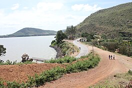
Vani Vilasa Sagara, popularly known as Mari Kanive is a dam in Hiriyur Taluk, Chitradurga District, in the Indian state of Karnataka. It is located about 21 km west of Hiriyur, 55 km south of Chitradurga, and 180 km north-west of Bengaluru.

<span class="mw-page-title-main">Krishna Raja Sagara</span> Dam in Mandya, Karnataka

Krishna Raja Sagara, also popularly known as KRS, is a lake and the dam that creates it. They are close to the settlement of Krishna Raja Sagara in the Indian State of Karnataka. The gravity dam made of surki mortar is below the confluence of river Kaveri with its tributaries Hemavati and Lakshmana Tirtha, in the district of Mandya.

<span class="mw-page-title-main">Vedavathi River</span> River in India

The Vedavathi is a river in India. It rises from the Bababudanagiri Mountains of Western Ghats and flows through the states of Karnataka and Andhra Pradesh. The Vedavathi is also called the Hagari in Bellary District of Karnataka and parts of Andhra Pradesh. Two rivers, the Veda and Avathi, arise in the eastern part of the Sahyadri Hill range in Bababudangiri mountain ranges, flow east, and join near Pura to form the Vedavathi River. From there the river flows through Kadur Taluk Of Chikkamagalur District. Then it enters Hosadurga Taluk, Hiriyur Taluk and Challakere Taluk of Chitradurga district, respectively.

<span class="mw-page-title-main">Tungabhadra River</span> River in southern India

The Tungabhadra River is a river in India that starts and flows through the state of Karnataka during most of its course, Andhra Pradesh and ultimately joining the Krishna River near Murvakonda in Andhra Pradesh

<span class="mw-page-title-main">Mettur Dam</span> Dam in Tamil Nadu, India

The Mettur Dam is one of the largest dams in India and also the largest in Tamil Nadu, located across the river Kaveri where it enters the plains. Built in 1934, it took 9 years to complete. Maximum height and width of the dam are 214 and 171 feet, respectively. The dam receives inflows from its own catchment area, Kabini Dam and Krishna Raja Sagara Dams located in Karnataka. There is a park at the base of the dam called Ellis Park maintained by the Tamil Nadu Public Works Department. It provides irrigation and drinking water facilities for more than 12 districts of Tamil Nadu and hence is revered as the life and livelihood-giving asset of Tamil Nadu.

Harihara is a city in Davanagere District in the Indian state of Karnataka. It is the administrative headquarters of the Harihara Taluk. Harihara is famous for Harihareshwara temple.

<span class="mw-page-title-main">Bayalu Seeme</span>

Bayaluseeme or Bayalu Seeme is the area lying to the east of Malenadu, a region of Karnataka state in India. The area is largely open plain, with few hillocks. It includes the districts of Bangalore, Bagalkot, Bijapur, Chitradurga, Davanagere, Dharwad, Gadag, Hassan, Haveri, Mandya, Mysore, and Tumkur.

<span class="mw-page-title-main">Shimoga district</span> District of Karnataka in India

Shimoga district, officially known as Shivamogga district, is a district in the Karnataka state of India. A major part of Shimoga district lies in the Malnad region or the Sahyadri. Shimoga city is its administrative centre. Jog Falls view point is a major tourist attraction. As of 2011 Shimoga district has a population of 17,52,753. There are seven taluks: Soraba, Sagara, Hosanagar, Shimoga, Shikaripura, Thirthahalli, and Bhadravathi. Channagiri and Honnali were part of Shimoga district until 1997 when they became part of the newly formed Davanagere district.

<span class="mw-page-title-main">Davanagere district</span> District in Karnataka, India

Davanagere district is an administrative district of Karnataka state in India. It is the centre of Karnataka. The city of Davanagere is the district headquarters. It had a population of 1,643,494 of which 32.31% was urban as of 2011. This district was separated from Chitradurga district in 1997 by the then Chief minister of Karnataka J. H. Patel including Chennagiri and Honali Taluks Shimoga district.

Channagiri is a town in Davanagere district in the state of Karnataka, India. It is a taluk headquarters in Davanagere District from 1997. Before it was the part of Shivamogga District.

<span class="mw-page-title-main">Tourism in Karnataka</span> Overview of tourism in Karnataka, India

Karnataka, the sixth largest state in India, has been ranked as the third most popular state in the country for tourism in 2014. It is home to 507 of the 3600 centrally protected monuments in India, second only to Uttar Pradesh. The State Directorate of Archaeology and Museums protects an additional 752 monuments and another 25,000 monuments are yet to receive protection.

<span class="mw-page-title-main">Geography of Karnataka</span>

The Indian State of Karnataka is located between 11°30' North and 18°30' North latitudes and between 74° East and 78°30' East longitude.It is situated on a tableland where the Western Ghats and Eastern Ghats converge into the complex, in the western part of the Deccan Peninsular region of India. The State is bounded by Maharashtra and Goa States in the north and northwest; by the Lakshadweep Sea in the west; by Kerala in the south-west and Tamil Nadu in the south and south-east, Andhra Pradesh in the south-east and east and Telangana in the north-east. Karnataka extends to about 850 km (530 mi) from north to south and about 450 km (280 mi) from east to west.

<span class="mw-page-title-main">S. Nijalingappa</span> Indian politician (1902–2000)

Siddavanahalli Nijalingappa was an Indian Congress Party politician, lawyer, and Indian independence activist. He was the fourth Chief Minister of Mysore State, serving two terms. In addition to the Indian independence movement, he played an important role in the Karnataka Unification movement.

<span class="mw-page-title-main">Chitradurga Fort</span> Fort in Karnataka, India

Chitradurga Fort, or as the British called it Chitaldoorg, is a fortification that straddles several hills and a peak overlooking a flat valley in the Chitradurga District, Karnataka, India. The fort's name Chitrakaldurga, which means 'picturesque fort' in Kannada, is the namesake of the town Chitradurga and its administrative district.

Karekatte is a village in the Indian state of Karnataka. Karekatte is located on Davanagere-Channagiri connecting road. At a distance of about 34 km (21 mi) from the Davanagere (District). At a distance of about 28.6 km (18 mi) from the Channagiri (Taluk).

Kerebilachi is a village in the southern state of Karnataka, India. It is located in the Nallur taluk of Davanagere district.

<span class="mw-page-title-main">Tungabhadra Dam</span> Dam in Karnataka, India

The Tungabhadra Dam, also known as Pampa Sagar, is a water reservoir constructed across the Tungabhadra River in the city of Hosapete in Vijayanagara district, Karnataka, India. It is a multipurpose dam serving irrigation, electricity generation, flood control, etc. for the state. It is one of the only two non-cement dams in India, the other being the Mullaperiyar Dam in Kerala. The dam is built of surki mortar, a combination of mud and limestone, commonly used at the time of its construction.

<span class="mw-page-title-main">Outline of Karnataka</span> Overview of and topical guide to Karnataka

The following outline is provided as an overview of and topical guide to Karnataka:

References

  1. Chandran, Rahul (5 November 2016). "Of legends and lakes built by courtesans". mint. Retrieved 7 January 2021.
  2. A lake with a history of 800 years... The Hindu - Online edition of India's National Newspaper
  3. Mysore: a gazetteer compiled for government, Vol 2 Page No. 482 Google Books Online
  4. Mysore: a gazetteer compiled for government, Vol 2 Page No. 482 Google Books Online
  5. "s". www.bl.uk. 3 April 2018. Retrieved 30 May 2018.
  6. "MV1aSAEZsc6IFMbf6SbvBO". www.livemint.com. 3 April 2018. Retrieved 30 May 2018.
  7. Mysore: a gazetteer compiled for government, Vol 2 Page No. 481 Google Books Online
  8. Mysore: a gazetteer compiled for government, Vol 2 Page No. 482 Google Books Online
  9. Sulekere in Davangere district has the distinction of being Asia’s second largest tank. The Hindu - Online edition of India's National Newspaper
  10. Imperial Gazetteer of India, v. 10, p. 173. Website of Digital South Asia Library
  11. "Occurrence Of The Eel (Anguilla bengaline) in Sulekere Reservoir and Markendaya Stream in Mysore State". Centre for ecological sciences Indian institute of science (IISc) Bangalore. 1955.
  12. Shanthi Sagara water for Chitradurga The Hindu - Online edition of India's National Newspaper
  13. Water supply system to get revamped Times of India - Online edition of India's National Newspaper
  14. "articleshow". timesofindia.indiatimes.com. 3 April 2018. Retrieved 30 May 2018.