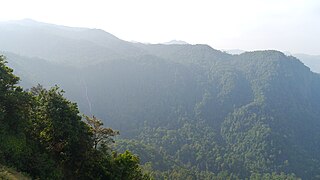
Ponmudi also known as Ooty of South Kerala, Kashmir of Kerala is a hill station in the Peringamala gramapanchayath of Trivandrum District of Kerala in India. It is located 22km west of Vithura town, 53 km north-east of Trivandrum City, 78 km south-east of Varkala town and 69 km north-east of Kovalam Beach at an altitude of 1,100 m (3,600 ft). Ponmudi (Varayadumotta) peak is a part of the Western Ghats mountain range that runs parallel to the Arabian Sea. Ponmudi is a popular honeymoon destination in South India. The normal temperature of Ponmudi is between 18 and 25 °C.

Kodachadri is a mountain peak with dense forests in the Western Ghats in South India, 78 km from Shimoga. Kodachadri is the highest peak in Shivamogga district. It is declared as natural heritage site by the Karnataka Government. and it is 13th highest peak of Karnataka.

Dudhsagar Falls is a four-tiered waterfall located on the Mandovi River in the Indian state of Goa. It is 60 km from Panaji by road and is located on the Belgaum–Vasco Da Gama rail route about 46 km east of Madgaon and 80 km south of Belgaum. Dudhsagar Falls is amongst India's tallest waterfalls with a height of 310 m (1017 feet) and an average width of 30 metres (100 feet).

Somwarpet is a panchayat town in Kodagu district in the Indian state of Karnataka. It is the main town of the Somwarpet taluk, in the north-east of the district. 2nd highest Administrative town in Karnataka in terms of elevation. The main crops grown in the area are coffee and spice crops such as cardamom, peppers, oranges, ginger and vegetables.

Bhandardara is a holiday resort village near Igatpuri, in the western ghats of India. The village is located in the Akole tehsil, Ahmednagar district of the state of Maharashtra, about 185 kilometers (115 mi) from Mumbai and 155 kilometers (96 mi) from Ahmednagar.
Hosanagara is a panchayat town in Shimoga district in the Indian state of Karnataka. It is nested in western ghats of India. The World Cattle Conference with main emphasis on cow was held in month of April 2007 in Hosanagar. The different uses of cow were exhibited. Near Hosanagar there is a mutt named Sri Ramachandrapura Math, 6 km from the town.

Mudigere is a Town Panchayath and Taluk in Chikkamagaluru district in the Indian state of Karnataka. It is 30 km from the district headquarters.

Karnataka, the sixth largest state in India, has been ranked as the third most popular state in the country for tourism in 2014. It is home to 507 of the 3600 centrally protected monuments in India, second only to Uttar Pradesh. The State Directorate of Archaeology and Museums protects an additional 752 monuments and another 25,000 monuments are yet to receive protection.

The Barkana Falls, formed by Seetha River, is a water falls located near Agumbe in Shimoga district of state of Karnataka, India and the water falls is among the ten highest waterfalls in India. This water fall region is filled with water only during rainy season.

Ujire is a town near Dharmasthala. It is in Belthangady taluk of Dakshina Kannada district. Ujire is an important junction for travelers in this region. The road at Ujire deviates to Dharmasthala, Kottigehara and Belthangady.
Kadaba is a taluk in Dakshina Kannada district of Karnataka, India. It is located 82 km towards East from District headquarters Mangalore, 31 km from Puttur, 38 km from Sullia and 272 km from State capital Bangalore.

Charmadi Ghat (Charmady) is a Ghat in Belthangady taluk of Dakshina Kannada and Mudigere taluk of Chikkamagaluru. It is one of the points in Western ghats through which motorable road passes connecting Dakshina Kannada with Chikkamagaluru district. The section of ghat is known by the name of Charmadi Ghat. It lies on National Highway 73 which connects Mangaluru to Tumkuru. The nearest places are Charmadi village, Ujire, Belthangady, Puttur, Kottigehara, Balur and Kalasa and Banakal.

Paithalmala is a hill station in the Kannur district of Kerala in India, located near Pottenplave. At a height of 1372 m above sea level, it is the highest geographic peak in Kannur. It is located 40 km from Taliparamba and 65 km from Kannur. Nestled in the Kerala Karnataka border near to Kodagu forests, it lies in the Western Ghats.
Masthikatte is a village located in Hosanagara Taluk, Shimoga district, Karnataka, India.pincode 577425

The Most Holy Redeemer Church is a historic Roman Catholic Church situated in the locality of Belthangady. The current structure of the church was built in 2012 during the tenure of Fr. James Dsouza. The original structure was constructed near the site of the present-day church building. It is the one of the oldest churches in Belthangady. This parish comes under Belthangady Varado which is a part of Roman Catholic Diocese of Mangalore.

The Deanery of Belthangady or Belthangady Varado is one of the deaneries which comes under Diocese of Mangalore located at Belthangady, Karnataka, India. This deanery consists 10 parishes and Most Holy Redeemer Church (Belthangady) is the primary parish for this Deanery. Fr. Joseph Cardoza is the current vicar of this Deanery.

The city of Mangalore is proclaimed as the gateway to Karnataka and lies nestled between the blue waters of the Arabian Sea and the green, towering hills of the Western Ghats. The 184 square km city is spread out over the backwaters of the two rivers, Netravati and Gurpura.
Shishila is a village located at the base of Western Ghats in Belthangady taluk of the Karnataka State, India. The main attraction of the village is a temple dedicated to Lord Shishileshwara.
State Highway 64, referred to as Kadur - Mangalore Road, is a state highway that runs through two districts in the state of Karnataka. The total length of the highway is 198.64 km. A part of this highway, from Kaduru to Mudigere, has been upgraded as NH-173, and from there to Bantawala, it has been upgraded as NH-73.


