 Vaigai Dam at Twilight
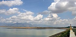 Vaigai Dam in the Daylight
 Vaigai dam closeup
 Vaigai dam Full view
 Vaigai dam backwater reservoir
 Vaigai dam sideview
 Aerial view
| Dam | |
|---|---|
 | |
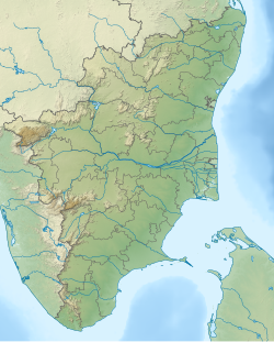 Dam Location of the Vaigai Dam in Tamil Nadu | |
| Official name | வைகை அணை |
| Country | India |
| Location | periyakulam, Theni district, Tamil Nadu |
| Coordinates | 10°03′12″N77°35′23″E / 10.05333°N 77.58972°E |
| Opening date | 29 January 1959 |
| Dam and spillways | |
| Height | 33.8 m (111 ft) |
| Length | 3,560 m (11,680 ft) |
| Reservoir | |
| Total capacity | 174,000,000 m3 (6.144752010×109 ft3) [1] (6.14 tmc ft) |
| Power Station | |
| Operator | Tamil Nadu Generation and Distribution Corporation Limited |
| Commission date | 3 April 1990 |
| Type | Gravity dam |
| Turbines | 2 x 3 MW |
| Installed capacity | 6 MW |
The Vaigai Dam is built across the Vaigai River near Andipatti, in the Theni district (Madurai district, before British India) of Tamil Nadu, South India. Near the dam, the Government of Tamil Nadu has constructed an Agricultural Research Station to research the cultivation of various crops, including rice, sorghum, black gram, cowpea and cotton. [2]


