
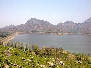
Pechiparai Reservoir is a reservoir located 43 kilometres (27 mi) from the town of Nagercoil, near the village of Pechiparai in Kanyakumari District, Tamil Nadu, India.It was built by the British chief engineer Humphreys Alexander Minchin were a pillar has been erected in remembrance.
Pothundi Dam is an irrigation dam near Pothundi village in the Palakkad district of Kerala state, India. Constructed in the 19th century, it is considered one of the oldest dams in India. It provides irrigation to an area of 5,470 hectares in the Palakkad district and drinking water supply to the Nemmara, Ayalur, Melarcode Panchayat. An unusual feature of the earth dam is the core wall, which is built with a mixture of jaggery and quick lime.

Nagarjuna Sagar Dam is a masonry dam across the Krishna River at Nagarjuna Sagar which straddles the border between Nalgonda district in Telangana and Guntur district in Andhra Pradesh. The dam provides irrigation water to the Nalgonda, Suryapet, Krishna, Khammam, West Godavari, Guntur, and Prakasam districts along with electricity generation.

Lake Qaraoun is an artificial lake or reservoir located in the southern region of the Beqaa Valley, Lebanon. It was created near Qaraoun village in 1959 by building a 61 m-high (200 ft) concrete-faced rockfill dam in the middle reaches of the Litani River. The reservoir has been used for hydropower generation, domestic water supply, and for irrigation of 27,500 ha.

Ujjani Dam, also known as Bhima Dam or Bhima Irrigation Project, on the Bhima River, a tributary of the Krishna River, is an earthfill cum Masonry gravity dam located near Ujjani village of Madha Taluk in Solapur district of the state of Maharashtra in India.

Aliyar (ஆழியாறு) (also spelt Azhiyar / Aaliyar) Reservoir is a 6.48 km2 (2.5 sq mi) reservoir located in Aliyar village near Pollachi town in Coimbatore District, Tamil Nadu, South India. The dam is located in the foothills of Valparai, in the Anaimalai Hills of the Western Ghats. It is about 65 kilometres (40 mi) from Coimbatore. The dam offers some ideal getaways including a park, garden, aquarium, play area and a mini Theme-Park maintained by Tamil Nadu Fisheries Corporation for visitors enjoyment. The scenery is beautiful, with mountains surrounding three quarters of the reservoir. Boating is also available.

The Rio Grande Project is a United States Bureau of Reclamation irrigation, hydroelectricity, flood control, and interbasin water transfer project serving the upper Rio Grande basin in the southwestern United States. The project irrigates 193,000 acres (780 km2) along the river in the states of New Mexico and Texas. Approximately 60 percent of this land is in New Mexico. Some water is also allotted to Mexico to irrigate some 25,000 acres (100 km2) on the south side of the river. The project was authorized in 1905, but its final features were not implemented until the early 1950s.

Upper Pus Dam, also called Pus Dam is an earthfill dam on Pus river near Pusad, Yavatmal district in the state of Maharashtra in India. There is another downstream dam near Mahagaon called Lower Pus Dam which was built in 1983. Other nearby dams are Arunawati Dam in Digras built in 1994 and Isapur Dam built in 1982.

The Upper Wardha Dam is an earthfill straight gravity dam across the Wardha River, a tributary of the Godavari River, near Simbhora village in Morshi taluk in Amravati district in the Indian state of Maharashtra. The dam provides multipurpose benefits of irrigation, drinking water supply, flood control and hydropower generation.

Idamalayar Dam is a multipurpose concrete gravity dam located at Ennakkal between Ayyampuzha and Bhoothathankettu in Ernakulam district of Kerala on the Idamalayar, a tributary of the Periyar River in Kerala, South India. The dam however extends east as far as Malakkappara. Completed in 1985, with a length of 373 metres (1,224 ft) and a height of 102.8 metres (337 ft), the dam created a multipurpose reservoir covering 28.3 km2 (10.9 sq mi) in the scenic hills of the Anamalais.

The Bhadra Dam or Lakkavalli Dam, which has created the Bhadra Reservoir, is located on the Bhadra River a tributary of Tungabhadra River. Bhadra Dam is located in the border of Bhadravathi and Tarikere, in the western part of Karnataka in India. The benefits derived from the reservoir storage are irrigation with gross irrigation potential of 162,818 hectares, hydro power generation of 39.2 MW, drinking water supply and industrial use. The dam commissioned in 1965 is a composite earth cum masonry structure of 59.13 metres (194.0 ft) height with length of 1,708 metres (5,604 ft) at the crest level, which submerges a land area of 11,250.88 hectares.

Thirparappu is a town located in the Kanyakumari District in the Indian state of Tamil Nadu. It is a popular tourist destination. It is 42 km (26 mi) from Nagercoil, headquarters of the Kanyakumari District, and 55 km (34 mi) from Thiruvananthapuram, the capital of the Indian state of Kerala. It is famous for its falls on the Kodayar (Kothai) River and the Pechiparai Dam, located 13 km (8.1 mi) away.
The Pranahita Chevella Lift Irrigation Project is a lift irrigation project to harness the water of Pranhita tributary of Godavari river for use in the Telangana state of India. The river water diversion barrage across the Pranahita river is located at Thammidihatti village in Komaram Bheem district of Telangana. This lift canal is an inter river basin transfer link by feeding Godavari river water to Krishna river basin. The chief ministers of Telangana and Maharashtra states reached an agreement in 2016 to limit the full reservoir level (FRL) of the barrage at 148 m msl with 1.85 tmcft storage capacity. In the year 2016, this project is divided into two parts. The scheme with diversion canal from the Thammmidihatti barrage to connect to existing Yellampalli reservoir across the Godavari river is presently called Pranahita barrage lift irrigation project. This scheme is confined to providing irrigation facility to nearly 2,00,000 acres in Adilabad district using 44 tmcft water.

Gibson Dam is a concrete arch dam on the Sun River, a tributary of the Missouri River, about 60 miles (97 km) west of Great Falls, Montana in the United States. Located on the eastern edge of the Rocky Mountains, the dam was built by the U.S. Bureau of Reclamation (USBR) between 1926 and 1929 as part of the Sun River Project to develop about 93,000 acres (38,000 ha) of irrigated land in the Sun River Valley.

Grahamstown Dam is a major off-stream earthfill Embankment dam with a controlled labyrinth spillway and baffle chute that stores water from the Williams River. The dam is located north of Newcastle and within the Port Stephens Council local government area in the Lower Hunter Region of New South Wales, Australia. The dam's main purpose is water supply; it provides about 40 per cent of the potable water for the Hunter region; and is the Hunter's largest drinking water supply dam.

The Pazhassi Dam also called Kulur Barrage is a stone masonry diversion structure in Kannur district, Kerala, India. It is named after king Pazhassi Raja, a patriot who died a heroic death in the war. The dam is constructed across the west flowing Bavali river near Veliyambra. It was commissioned by Prime Minister Morarji Desai in 1979. It mainly functions as an irrigation dam, serving a command area of 11,525 hectares in Iritty taluk of the Kannur District. The water from this dam also meets the drinking water requirement of Kannur district. The dam site and the reservoir are famous for their scenic beauty.

Wushantou Dam is an embankment dam in Guantian District, Tainan, Taiwan. The dam was designed by Yoichi Hatta and built between 1920 and 1930 during Japanese rule to provide irrigation water for the Chianan Plain as part of the Chianan Irrigation system. Because the natural flow of the Guantian River and other local streams was insufficient for irrigation of a planned 100,000 ha, a tunnel was constructed to divert water from the Zengwun River to fill the reservoir. In 1974, the Zengwun Dam was completed on the Zengwun River shortly above the diversion tunnel, stabilizing and reducing the sediment load of water flowing into Wushantou Reservoir.
Lower Manair Dam also known as LMD was constructed across the Manair River, at Alugunur village, Thimmapur mandal, Karimnagar District, in the Indian state of Telangana during 1974 to 1985. It provides irrigation to a gross command area of 163,000 hectares.

The Kanjirapuzha Dam, a masonry earth dam built for providing irrigation to a Cultural Command Area (CCA) of 9,713 hectares, is located in the Palakkad district in the Indian state of Kerala. The reservoir, which has three islands within it, also has an established commercial fisheries development programme operated by the Fisheries Department.
Narakakkanam Weir is a diversion dam constructed across Narakakkanam River in Mariyapuram panchayath of Thankamani Village in Idukki district in Kerala, India. Narakakkanam weir is an augmentation weir for the Idukki Hydro Electric Project. Narakakkanam, Azhutha, Vazhikkadavu, Vadakkepuzha and Kuttiar diversion schemes were later added to augment the Idukki reservoir. The height of the dam is 11.50 metres (37.7 ft) from the deepest foundation and length is 45.20 metres (148.3 ft).


