Salcete is a sub-division of South Goa district, Goa state, situated along the south-west coast of India. The Sal river and its backwaters dominate the landscape of Salcete. Historically, the sixty-six villages south of the Zuari river formed the original Salcette territory. Salcete forms a part of the bigger Konkan coastal region thats stretches north–south through most of India's western shoreline.

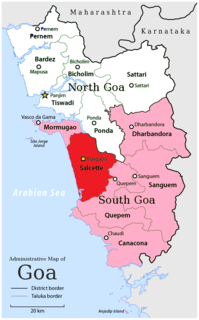
South Goa is one of two districts that comprises the state of Goa in India, within the region known as the Konkan. It is bounded by North Goa district to the north, the Uttara Kannada district of Karnataka state to the east and south, while the Arabian Sea forms its western coast.
Sindhudurg is an administrative district of the Konkan division in India, which was carved out of the erstwhile Ratnagiri district. The district headquarters are located at Oros. The district occupies an area of 5,207 km2 and has a population of 849,651 of which 12.59% were urban. As of 2011 it is the least populous district of Maharashtra.

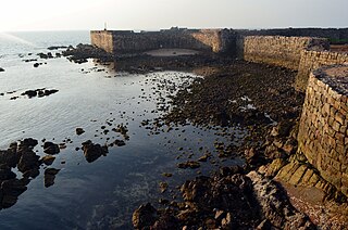
Mormugao is a seaport city situated in the eponymous Morumugão Sub-District of the district of South Goa, Goa state, India. It has a deep natural harbour and is Goa's chief port.

Ajara is a census town and taluka headquarters Of Ajara taluka in Kolhapur district in the state of Maharashtra, India.

Canacona is a city and a municipal council in the district of South Goa, Goa state, India. Canacona taluka includes Patnem, Chaudi, Poinguinim, Loliem-Polem, Agonda, and Gaumdongre. Chaudi is the headquarters and the most developed town in this taluka. The famous Palolem Beach is located in Canacona.
Dhatav is a Village in Roha Taluka in Raigad district in the state of Maharashtra, India. Dhatav connected through Mumbai & Pune through Mumbai Goa Highway in kolad
In India and Pakistan, a tehsildar is a tax officer accompanied by revenue inspectors. They are in charge of obtaining taxes from a tehsil with regard to land revenue. A tehsildar is also known as an Executive Magistrate of the tehsil concerned.
Chandgad is a Small city and tehsil headquarters of chandgad taluka, of Kolhapur district that is in the Indian state of Maharashtra.
Sattari is a sub-district of North Goa district in the state of Goa, India. The headquarters of Sattari taluka is Valpoi (वाळपई) municipal council. It lies in the north-eastern region of Goa where it is known for its greenery and dense forest. Part of the Western Ghats forms the eastern part of the Sattari taluka. The Mandovi River is considered to be the lifeline of Sattari. It has a geographical area of 490 km2; the Mhadei Wildlife Sanctuary covers 208 km2 of this area.
The Government of Goa is the state government created by Constitution of India and has executive, legislative and judicial authority of state of Goa. It is located in Panaji, Goa.
A tehsil also known as tahsil, taluka, or taluk) is a local unit of administrative division in some countries of the South Asia that is usually translated to "township". It is a subdistrict of the area within a district including the designated city, town, hamlet, or other populated place that serves as its administrative centre, with possible additional towns, and usually a number of villages. The terms in India have replaced earlier geographical terms, such as pargana (pergunnah) and thana.
Ajgaon is a village in the state of Maharashtra, India. It is located in the Sawantwadi taluk of Sindhudurg district in Maharashtra.
Rivona or Rivana is a census town in Sanguem taluka, South Goa district in the state of Goa, India.

Pondataluka is a subdivision of the district of South Goa, Goa state, India. Its administrative headquarters is the township of Ponda.
Tala is a small town and taluka in Mangaon subdivision of Raigad district of Maharashtra State in India. Tala is 15 km away from Indapur Town which is located on Mumbai-Goa Highway. Talgad is main attraction of Tala which is one of the important fort in Raigad district. Chandika Mata Temple is located at Marketplace of Tala village. Tala is Marathi translation of word lake, and there were many lakes located in Tala village which is also the reason behind the name Tala.
Kanakumbi is a village in Belgaum district in Karnataka, India. It is situated on border of Satteri taluka, Goa. Near by cities are Mapusa 65 km, Panaji 71 km, Belagavi city 45 km.

Dharbandora is a sub-division and Taluka of Goa, India. At present, it has a population of 30,000 to 40,000 people.
Pernem railway station is a railway station in North Goa district of Goa state.
