Pathanamthitta District, is one of the 14 districts in the Indian state of Kerala. The district headquarters is in the town of Pathanamthitta. There are four municipalities in Pathanamthitta: Adoor, Pandalam, Pathanamthitta and Thiruvalla.

Kanjirappally is a taluk and a town in Kottayam district situated about 38 km (24 mi) away from the district capital, in the state of Kerala, India.
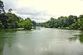
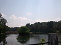
Thiruvalla, alternately spelled Tiruvalla, is a town in Kerala and also the headquarters of the Taluk of same name located in Pathanamthitta district in the State of Kerala, India. The town is spread over an area of 27.94 km. It lies on the banks of the river Pamba and river Manimala, and is a land-locked region surrounded by irrigating streams and rivers.
Mundakayam, is a town in Kanjirappally Taluk in the Kottayam District of Kerala. It is the doorway to the high ranges of southern Kerala, and is at the border of Kottayam and Idukki districts. The next nearest town, Kanjirappally, is 14 km (8.7 mi) & Erumely is 12 km from Mundakayam. Mundakayam has rubber plantations, and greenery. The Manimala River runs through Mundakayam. It is located 48 km east of the district headquarters at Kottayam and 148 km from the state capital, Thiruvananthapuram. The name Mundakayam is said to be derived from the Mundi cranes that used to be seen along the Manimala River banks.

The Kerala backwaters are a network of brackish lagoons and lakes lying parallel to the Arabian Sea coast of Kerala state in southern India, as well as interconnected canals, rivers, and inlets, a labyrinthine system formed by more than 900 kilometres (560 mi) of waterways, and sometimes compared to American bayous. The network includes five large lakes linked by canals, both man made and natural, fed by 38 rivers, and extending virtually half the length of Kerala state. The backwaters were formed by the action of waves and shore currents creating low barrier islands across the mouths of the many rivers flowing down from the Western Ghats range. In the midst of this landscape there are a number of towns and cities, which serve as the starting and end points of backwater cruises. There are 34 backwaters in Kerala. Out of it, 27 are located either closer to Arabian Sea or parallel to the sea. The remaining 7 are inland navigation routes.

Vembanad is the longest lake in India, as well as the largest lake in the state of Kerala. With an area of 2033 square kilometers and a maximum length of 96.5 km, it is the second largest Ramsar site in India only after the Sunderbans in West Bengal. Spanning several districts in the state of Kerala, it is known as Vembanadu Lake in Kottayam, Vaikom, Changanassery, Punnamada Lake in Alappuzha, Punnappra, Kuttanadu and Kochi Lake in Kochi. Several groups of small islands including Vypin, Mulavukad, Maradu, Udayamperoor, Vallarpadam, Willingdon Island are located in the Kochi Lake portion. Kochi Port is built around the Willingdon Island and the Vallarpadam island.

Niranam is a village in Tiruvalla, Kerala, India. It was a port in ancient Kerala, on the confluence of the Manimala and Pamba River. It is almost 8 km from Tiruvalla SCS Junction in Pathanamthitta District of Kerala, lies to the western part of Tiruvalla, identified as Upper Kuttanad region. It can be identified with Nelcynda in Periplus of the Erythraean Sea.

Kuttanad is a region covering the Alappuzha, Kottayam and Pathanamthitta Districts, in the state of Kerala, India, well known for its vast paddy fields and geographical peculiarities. The region has the lowest altitude in India, and is one of the few places in the world where farming is carried on around 1.2 to 3.0 metres below sea level. Kuttanad is historically important in the ancient history of South India and is the major rice producer in the state. Farmers of Kuttanad are famous for Biosaline Farming. Food and Agriculture Organization (FAO) has declared the Kuttanad Farming System as a Globally Important Agricultural Heritage System (GIAHS).

Periyar, IPA: [peɾijɐːr], is the longest river and the river with the largest discharge potential in the Indian state of Kerala. It is one of the few perennial rivers in the region and provides drinking water for several major towns. The Periyar is of utmost significance to the economy of Kerala. It generates a significant proportion of Kerala's electrical power via the Idukki Dam and flows along a region of industrial and commercial activity. The river also provides water for irrigation and domestic use throughout its course besides supporting a rich fishery. Due to these reasons, the river has been named the "Lifeline of Kerala". Kochi city, in the vicinity of the river mouth draws its water supply from Aluva, an upstream site sufficiently free of seawater intrusion. Twenty five percent of Kerala's industries are along the banks of river Periyar. These are mostly crowded within a stretch of 5 kilometres (3 mi) in the Eloor-Edayar region (Udhyogamandal), about 10 kilometres (6 mi) north of Kochi harbor.

The MeenachilRiver also called Gauna, Kavanar, Valanjar flows through the heart of Kottayam district, Kerala state in southern India. 78km long, originates in the Western Ghats main tributaries are theekoy aaru from vagamon hills, poonjar aaru and chittar,flowing westward through the city of Kottayam and other towns like Poonjar, Teekoy, Erattupetta, Bharananganam, Pala, Mutholy, Cherpunkal, Kidangoor and Kumarakom before emptying into the Vembanad Lake on the shore of the Indian Ocean.

The Syro Malabar Catholic Archeparchy of Changanacherry-Niranam is a Syro-Malabar Catholic archeparchy with an area of 24,595 km2 comprising the districts of Kottayam, Alappuzha, Pathanamthitta, Kollam, and Thiruvananthapuram in Kerala, and also Kanyakumari district in Tamil Nadu. It is one of the largest Catholic dioceses in India in terms of area. Mar Joseph Perumthottam is the current Metropolitan Archbishop, serving since 2007. Mar Thomas Tharayil has been the auxiliary bishop since 2017. And Mar Joseph Powathil is the bishop emeritus, having served from 1985 to 2007. Suffragan eparchies of the Changanassery archeparchy includes Palai, Kanjirappally-Nilackal, and Thuckalay-Thiruvithancode.

Achankovil is a 128 km long west flowing river in Kerala, India, which flows through Kollam, Pathanamthitta, and Alappuzha districts. The river drains vast tract of fertile plains of Upper Kuttanad in the Alappuzha and Pathanamthitta districts. It also sustains numerous urban settlements along its course such as Konni, Pathanamthitta, Pandalam, Mavelikkara etc.

The Pamba River is the longest river in the Indian state of Kerala after Periyar and Bharathappuzha, and the longest river in the erstwhile former princely state of Travancore. Sabarimala temple dedicated to Lord Ayyappa is located on the banks of the river Pamba.

Kainakary is a village in Kuttanad Taluk in Alappuzha District of the Indian state of Kerala.

Ponkunnam (പൊൻകുന്നം) is a census town in Kerala, India, part of Kottayam district under Kanjirappally taluk. Ponkunnam literally means golden mountain (ponn = gold, kunn = mountain). Nearby towns are Kanjirappalli, Manimala and Pala. This part of Kerala is famous for its fertile land and rubber plantations. It is at an altitude of 495 ft (151 m) above mean sea level. The town is at the junction of two major roads in Kerala: NH220 and Main Eastern Highway. The climate is moderate with timely cold breezes and the town is the gateway to the Western Ghats. The town is famous for its volleyball traditions and customs. Almost every year there is an ever-rolling volleyball tournament happening in Ponkunnam Mahatma Gandhi Mini Stadium.
Keezhvaipur is a village in the Mallappally Taluk which is one of five Taluks that makes up the Pathanamthitta district, in Kerala State, India. Keezhuvaipur lies in the bank of river Manimala and is famous for its traditions, cultures, and customs. The town is located on the Kottayam-Punalur State Highway. Keezhuvaipur is 3 km away from Mallappally, 11 km from Kozhencherry and 13 km from Tiruvalla.

State Highway 11 is a State Highway in Kerala, India that starts in Kalarcode, Alappuzha and ends in Perunna, Changanassery.The road is popularly known as AC road road. The highway is 24.2 km long.The road is closed for renovation from August 2021 for Two years
Tiruvalla Taluk Taluk is a Tehsil in the Pathanamthitta district of Kerala, India. The headquarters of the Taluk is at Tiruvalla town itself, which lies almost in the centre of the Taluk. The borders are Maramon on east, Idinjillam on North, Chakkulathukavu & Parumala (Thiruvalla) on the west, and Kuttoor Arattukadavu Bridge To Pravinkoodu in the South.Thiruvalla Is Also An Educational District.,The Thiruvalla Educational District.All Three Major rivers in Central Travancore Pamba and Manimala & Achenkovil River flow through this Taluk.It is Also Called The Land Of Rivers as All Three Major Rivers Flow Through Thiruvalla to Reach Vembanad Lake Via Kuttanad.

Azhuthayar is a tributary of the Pamba River, the third longest river in the South Indian state of Kerala. It originates from Peerumedu, flows through dense forests and reaches Koruthodu. From there it forms the boundary between Kottayam and Idukki districts. It then crosses Sabarimala traditional trekking path at Kalaketti area before joining with Pamba river at Kanamala(Pambavalley). Like its parent river, it is also closely related to the legend of Lord Ayyappan, a popular Hindu deity worshipped mainly in Kerala. It flows through a place also named Azhutha, which is on the Sabarimala trek route from Erumeli to Sabarimala. The river Pamba, ultimately flows around 180 kilometres (112 mi) through towns and villages Ranni, Cherukolpuzha, Maramon, Aranmula, Chengannur, Parumala, Neerettupuram, Kavalam, Nedumudi and Thakazhy before joining Vembanad lake.
Puntius madhusoodani is a species of fish in the family Cyprinidae in Puntius genus. The species has been discovered in 2010, named and described jointly by Krishnakumar, Benno Pereira & Radhakrishnan and a study first published in Biosystematica in 2012. It was collected from Manimala River in Kerala, India, which has a running length of only 92 km and empties into the Vembanad Lake. Puntius madhusoodani is named after Prof. Dr. B. Madhusoodana Kurup, as an honour for his contribution towards the taxonomy and conservation of freshwater fishes of Kerala.