
Kollam, also known by its former name Quilon, is an ancient seaport and city on the Malabar Coast of India bordering the Laccadive Sea, which is a part of the Arabian Sea. It is 71 km (44 mi) north of the state capital Thiruvananthapuram. The city is on the banks of Ashtamudi Lake and the Kallada river. Kollam is the fourth largest city in Kerala and is known for cashew processing and coir manufacturing. It is the southern gateway to the Backwaters of Kerala and is a prominent tourist destination. Kollam is one of the most historic cities with continuous settlements in India. Geographically, Quilon formation seen around coastal cliffs of Ashtamudi Lake, represent sediments laid down in the Kerala basin that existed during Mio-Pliocene times.
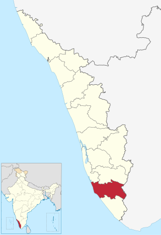
Kollam district, is one of 14 districts of the state of Kerala, India. The district has a cross-section of Kerala's natural attributes; it is endowed with a long coastline, a major Laccadive Sea seaport and an inland lake. The district has many water bodies. Kallada River is one among them, and the east side land of river is East Kallada and the west side land is West Kallada.

Chathannoor is a town in the Indian state of Kerala situated at the Kollam District on the banks of Ithikkara River. It is about 16 km (9.9 mi) from Kollam(Quilon) City. Chathannoor is around 55 km (34 mi) north of the state capital Thiruvananthapuram(Trivandrum). Chathannoor is a Special Grade Panchayath and is one of the fastest developing towns in Kerala.. Shri Diju is the current president of Chathannoor Grama Panchayat.

Paravur Kayal is a lake in Paravur, Kollam district, Kerala, India. Although it is small, with an area of only 6.62 km², it is the end point of the Ithikkara River and part of the system of lakes and canals that make up the Kerala Backwaters. It has been connected to Edava and Ashtamudi Kayal as part of the Trivandrum - Shoranur canal system since the late 19th century.
Karunagappally is a municipality in the Kollam district of Kerala, India. It is 24 km north of Kollam and 60 km (37 mi) south of Alappuzha. Karunagappally taluk consists of Alappad, Ochira, Adinad, Karunagappally, Thazhava, Pavumba, Thodiyoor, Kallalibhagom, Thevalakkara, Chavara, Neendakara, Clappana, Kulasekharapuram, Thekkumbhagam, Ayanivelikulangara, Panmana, Ponmana and Vadakumthala. The taluk is bound on the north by Kayamkulam, on the east by Kunnathur taluk, on the south by Kollam and on the west by the Arabian Sea. It is one of the fastest developing towns in Kerala and is part of Kollam metropolitan area.

Punthalathazham is a landlocked neighbourhood of the city of Kollam in the Indian state of Kerala. It is located around six kilometres east of the core Kollam (Quilon) city towards Kannanalloor . This place has a little geographical importance and serves as the tail boundary of Kollam Municipal Corporation. Inhabitants belong to working and middle classes.

Ithikkara is a place in Kollam district, Kerala, India, about 13 km from Kollam city. It received its name from Ithikkara River.

Kollam Junction railway station is a junction station situated in the city of Kollam in Kerala, India. It is the second largest railway station in Kerala in terms of area and largest in terms of number of tracks and one of the oldest railway stations in the state. It is also the second busiest railway station in Kerala in terms of trains handled per day. World's third longest railway platform is situated at Kollam railway station.

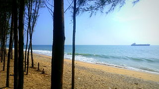
Pozhikkara or Pozhikara is the Western border town of the Paravur municipality in the Kollam district of Kerala state in India. It is located at the South-Western tip of Kollam's coastal area. It is in the Arabian Sea coast. Pozhikara is a heritage site in Kerala. Visitors, including foreign visitors come to Paravur and Pozhikara to see the estuary, backwaters and beaches. As per the 2018 study report by Central Marine Fisheries Research Institute(CMRFRI) of India, Pozhikkara beach is one of the 16 best-kept beaches in India, topper from the state of Kerala.
Nedungolam or Nedumgolam is the Northern border town of Paravur municipality in the Kollam district of Kerala state, India. Nedungolam is very near to the world-famous-wetland in Kollam district, Polachira, which is a favorite destination for migratory birds. A census conducted on 2003 reveals that over 26,000 birds belonging to 37 species are visiting or living in the Polachira wetlands.
Mundakkal, also spelt Mundackal, is an important residential area and industrial hub situated in the city of Kollam, Kerala, India. The place is considered as the capital of India's cashew processing activities. Kerala State Cashew Development Corporation Limited(KSCDC) and Cashew Export Promotion Council of India(CEPCI) are headquartered at Mundakkal in Kollam city. It is an important tourist place in the city and a part of Downtown Kollam which gained in significance because of the presence of a flourishing beach. During 'Karkidaka Vavubali', thousands of devotees arrive on the beach to perform the Vavubali Tharpanam. Vavubali is an important ritual observed by Hindus in Kerala in the month of Karkidakam. The ritual involves people offering Bali to the departed souls. The ritual is performed by men, women, and children.
Maruthadi or Maruthady is a coastal town situated in the city of Kollam, Kerala, India. The place is very famous in the state for its fishing activities. The presence of Kattaka Kayal, a two-km long stream that once served as the lifeline for most of the commercial activities at Sakthikulangara and the 36-acre Vattakayal are making Maruthadi an important tourism spot in the city.

Kilikolloor, also known as Kilikollur, is a neighbourhood in Kollam district in Kerala, India. It is a center of the cashew industry in the area, and is also a hub of automobile production.

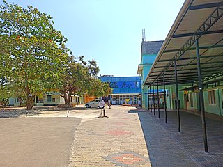
Government Medical College, Kollam, formerly ESIC Medical College, Parippally, is the first Government medical college in Kollam district, Kerala, India. It is situated 21 km (13 mi) south of Kollam city and 9.6 km (6.0 mi) east of Paravur town. The College was initially established by the Employees State Insurance Corporation, a Government of India establishment, and later acquired by the Government of Kerala.

Karunagappalli railway station(Code:KPY) or Karunagappally railway station is a railway station in the Indian municipal town of Karunagappalli in Kollam district, Kerala. Karunagappalli railway station falls under the Thiruvananthapuram railway division of the Southern Railway zone of Indian Railways. Karunagappally KSRTC Bus Station is only 2 km away from the station. It is one among the railway stations in Kerala collecting crores of rupees through passenger tickets every year. Karunagappalli is the nearest railway station to Amritapuri. Free WiFi of railway is available here. Karunagappalli is connected to various cities in India like Kollam, Trivandrum, Kochi, Calicut, Palakkad, Thrissur, Punalur, Bengaluru, Udupi, Mumbai, Madurai, Kanyakumari, Vishakapatnam, Mangalore, Pune, Salem, Coimbatore, Trichy, Tirunelveli, Hyderabad etc. through Indian Railways. In 2019, the rail wi-fi broad-band connection has been introduced in Karunagappalli station.karunagappally - KMML Chavara railway line is a defunct railway line which used to carry goods to KMML in past.kothukumukku railway bridge in this old line is a tourist attraction now.

Munroturuttu railway station or Mundrothuruthu railway station(Code:MQO) is an 'HG 2 Category' halt railway station, situated between Perinad and Sasthamkotta railway stations of Kollam district in Kerala state, India. The station is coming under the Southern Railway zone of Indian Railways. The nearest major rail head of Munrothuruthu railway station is Kollam Junction railway station.

Transport in Kollam includes various modes of road, rail and water transportation in the city and its suburbs. State-owned Kerala State Road Transport Corporation buses, private buses, Indian Railways, state-owned Kerala State Water Transport Department boats & ferry, taxis and auto rickshaws are serving the city of Kollam. The city had a strong commercial reputation since the days of the Phoenicians and Romans. Ibn Battuta mentioned Kollam Port as one of the five Indian ports he had seen during the course of his twenty-four year travels.
Mulamkadakam or Mulangadakam/Mulamkadakom is a neighbourhood of Kollam (Quilon) city, India. It is situated at the northern region of the city. Mulamkadakam is the 7th ward of Kollam Municipal Corporation which is in Sakthikulangara zone of the city. Devi temple at Mulamkadakam is famous in the state. Kerala University's University Institute of Technology centre is situated at Mulamkadakam.

Kollam KSWTD Boat Jetty or Kollam KSWTD Ferry Station is an transport hub in the city of Kollam in Kerala, India, one of 14 ferry stations owned by the Kerala State Water Transport Department.

City of Kollam or Quilon is a Port city in South India and was the commercial capital of erstwhile Kingdom of Travancore. It is situated on the Laccadive Sea coast of South Kerala. The city is known as the "Gateway to the backwaters of Kerala". The city lies on the banks of Ashtamudi Lake, Kerala's second largest lake, on the Arabian sea coast. Major parts of Kollam city are covered by Ashtamudi Lake.


